La Plata Peak
| La Plata Peak | |
|---|---|
 | |
| Highest point | |
| Elevation | 14,343 ft (4372 m) [1] NAVD88 |
| Prominence | 1836 ft (560 m) [1] |
| Isolation | 6.28 mi (10.11 km) [1] |
| Listing | |
| Coordinates | 39°01′46″N 106°28′22″W / 39.0293524°N 106.4729047°WCoordinates: 39°01′46″N 106°28′22″W / 39.0293524°N 106.4729047°W [2] |
| Geography | |
 La Plata Peak | |
| Location | Chaffee County, Colorado, U.S.[2] |
| Parent range |
Sawatch Range, Collegiate Peaks[1] |
| Topo map |
USGS 7.5' topographic map Mount Elbert, Colorado[2] |
| Climbing | |
| First ascent | July 26, 1873 Hayden Survey |
| Easiest route | Northwest Ridge or Southwest Ridge: Hike (class 2) |
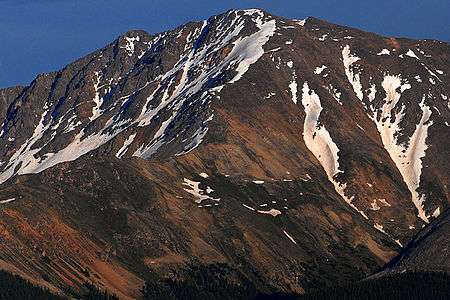
La Plata Peak is the fifth-highest summit of the Rocky Mountains of North America and the U.S. state of Colorado. The prominent 14,343-foot (4,372 m) fourteener is located in the Collegiate Peaks Wilderness of San Isabel National Forest, 22.7 miles (36.5 km) northwest by west (bearing 308°) of the Town of Buena Vista in Chaffee County, Colorado, United States.[3][1][2]
"La Plata" is Spanish for "The Silver", a reference to the many silver deposits in the area. The nearby ghost towns of Winfield and Hamilton were prominent silver mining towns in the early part of the 20th century. A Hayden Survey team first climbed the peak on July 26, 1873.[4]
The elevation of 14,361 feet marked on the USGS Mount Elbert Quadrangle is incorrect, and should read 14,336 feet (in the NGVD 29 vertical datum).[5]
Climbing Routes
There are two commonly used routes to climb the mountain. One route begins near Winfield, to the south of the peak, and climbs north into a large marshy basin at 12,000 feet (3,700 m). From here the trail becomes steeper as it scales a headwall to 13,000 feet (4,000 m). From the top of the headwall it is a short rock scramble to the summit. The other route approaches the summit from the north. The trail starts from Highway 82 and follows the northern ridge that divides the La Plata basin from La Plata Gulch. Another much more challenging route is the northeast arm of the peak known as Ellingwood Ridge, a very tough Class 4 climb with 6,000 feet of elevation gain.

See also
References
- 1 2 3 4 5 "La Plata Peak, Colorado". Peakbagger.com. Retrieved January 2, 2016.
- 1 2 3 4 "La Plata Peak". Geographic Names Information System. United States Geological Survey. Retrieved October 20, 2014.
- ↑ The elevation of La Plata Peak includes an adjustment of +1.983 m (+6.51 ft) from NGVD 29 to NAVD 88.
- ↑ "La Plata Peak". SummitPost.org. Retrieved 2008-11-30.
- ↑ Gerry Roach (1999). Colorado's Fourteeners: From Hikes to Climbs. Fulcrum Publishing. pp. 98–. ISBN 978-1-55591-412-7.
External links
- "La Plata Peak". Colorado Fourteeners Initiative. Retrieved 2008-11-30.
- "La Plata Peak Trail". San Isabel National Forest. US Forest Service. Retrieved 2008-11-30.
- "La Plata Peak". 14ers.com. Retrieved 2014-08-17.
