Mount Lyell (California)
| Mount Lyell | |
|---|---|
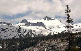 Mount Lyell, June 2005 | |
| Highest point | |
| Elevation | 13,120 ft (3,999 m) NAVD 88[1] |
| Prominence | 1,927 ft (587 m) [2] |
| Parent peak | Mount Ritter[3] |
| Listing |
|
| Coordinates | 37°44′22″N 119°16′18″W / 37.739424367°N 119.271568894°WCoordinates: 37°44′22″N 119°16′18″W / 37.739424367°N 119.271568894°W [1] |
| Geography | |
 Mount Lyell  Mount Lyell
| |
| Location | Madera and Tuolumne counties, California, U.S. |
| Parent range | Cathedral Range, Sierra Nevada |
| Topo map | USGS Mount Lyell |
| Climbing | |
| First ascent | August 29, 1871 by John Boies Tileston[7] |
| Easiest route | Exposed scramble, class 3[5] |
Mount Lyell is the highest point in Yosemite National Park, at 13,114 feet (3,997 m). It is located at the southeast end of the Cathedral Range, 1.2 miles (1.9 km) northwest of Rodgers Peak. The peak as well as nearby Lyell Canyon is named after Charles Lyell, a well-known 19th century geologist.[8] The peak had one of the last remaining glaciers in Yosemite, Lyell Glacier. The Lyell Glacier is currently considered to be a permanent ice field, not a living glacier. Mount Lyell divides the Tuolumne River watershed to the north, the Merced to the west, and the Rush Creek drainage in the Mono Lake Basin to the southeast.
Climbing
The most common approach to Mount Lyell is from Tuolumne Meadows on a highly traveled section of the John Muir Trail. The round trip is approximately 25 miles (40 km) and involves 4,500 feet (1,370 m) of elevation gain when starting from the Tuolumne Wilderness Office. The hike is easy from Tuolumne Meadows, following the Tuolumne River to the head of the Lyell Canyon, and becomes moderate as it approaches Donohue Pass. Before reaching Donahue Pass, the route leaves the trail and heads south towards Mount Lyell.
Most summit ascents are done either over or around the Lyell Glacier. Seasonal and year-to-year variations on the glacier make it necessary to assess current conditions before choosing a route to the summit. The northwest Ridge, from the saddle between Mount Lyell and nearby Mount Maclure, offers class 2 to 3 climbing with high snow levels on the glacier. Low snow levels increases the grade to class 3 to 4 on the exposed granite ledges, in which cases it may be easier to ascend the glacier more directly to the summit.
The summit block of Mount Lyell is composed of dark volcanic granite, similar to its neighbors do the southeast, Rodgers Peak, Mount Davis, Banner Peak, and Mount Ritter. This rock is very loose and unstable for climbing, making the ascent to the summit plateau dangerous when the glacier is low, exposing the lower reaches of the summit block. For this reason, some climbers consider Mount Lyell and nearby Mount Maclure to actually be geologically part of the Ritter Range.
The grade of the East Arete likewise increases with low snow conditions, going from class 3 to class 4 (the looseness of the rock underlying the glacier on the East Arete makes it somewhat dangerous in low snow conditions). Other routes exist on the south and west sides, but of greater difficulty and longer approaches.
See also
References
- 1 2 "Lyell 2". NGS data sheet. U.S. National Geodetic Survey. Retrieved 2009-06-22.
- ↑ "Mount Lyell, California". Peakbagger.com. Retrieved 2009-06-22.
- ↑ "Mount Lyell". ListsOfJohn.com. Retrieved 2012-03-31.
- ↑ "U.S. National Park High Points". Peakbagger.com. Retrieved 2016-03-27.
- 1 2 "Sierra Peaks Section List" (PDF). Angeles Chapter, Sierra Club. Retrieved 2008-09-28.
- ↑ "Western States Climbers List". Climber.org. Retrieved 2016-03-27.
- ↑ Secor, R.J. (2009). The High Sierra Peaks, Passes, and Trails (3rd ed.). Seattle: The Mountaineers. pp. 415–417. ISBN 9780898869712.
- ↑ Farquhar, Francis P. (1926). Place Names of the High Sierra. San Francisco: Sierra Club. Retrieved 2009-06-22.
- Townsend, Charles E. (July 1899). "A Trip To Mount Lyell". XXXIV (19): 567–588.
External links
- "Mount Lyell". Geographic Names Information System. United States Geological Survey.
- "Mount Lyell". SummitPost.org.
- "Mount Lyell". County Highpointers. Retrieved 2009-08-12.
- "Mount Lyell from Tuolumne Meadows via Lyell Canyon". Yosemite Explorer. Retrieved 2009-08-12.
- Russell, Carl Parcher (1947). One Hundred Years In Yosemite. Yosemite National Park: Yosemite Association. p. 78. ISBN 0-939666-60-X.