Spruce Knob
| Spruce Knob | |
|---|---|
 Spruce Knob summit | |
| Highest point | |
| Elevation | 4,863 ft (1,482 m) NAVD 88[1] |
| Prominence | 2,781 ft (848 m) [2] |
| Listing | |
| Coordinates | 38°42′00″N 79°31′58″W / 38.699867514°N 79.532791614°WCoordinates: 38°42′00″N 79°31′58″W / 38.699867514°N 79.532791614°W [1] |
| Geography | |
 Spruce Knob Pendleton County, West Virginia, U.S. | |
| Parent range | Allegheny Mountains |
| Topo map | USGS Spruce Knob |
| Climbing | |
| Easiest route |
Drive-up via |
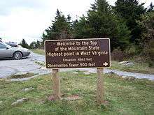
Spruce Knob, at 4,863 feet (1,482 m),[1] is the highest point in the state of West Virginia and the summit of Spruce Mountain, the highest peak in the Allegheny Mountains.[2]
Overview
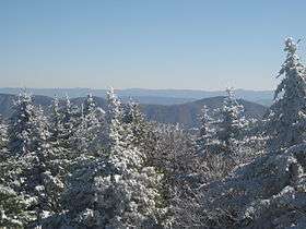
The summit of Spruce Knob has a definite alpine feel, much more so than most other mountains of the Southern Appalachians. The upper few hundred feet are covered in a dense spruce forest, a relic boreal forest environment similar to those found in northern New England and Canada. The summit is accessible both via trails and a paved Forest Service road, and is crowned with a stone lookout tower amid a mixture of boulder fields, meadows and trees. A handicap-accessible nature trail half a mile (0.8 km) long circles the topmost part of the mountain. High west winds near the summit have gnarled the spruce there like Krummholz, flagged with limbs only on their leeward (eastward) side.
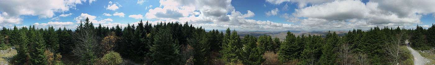
As is typical in the southern Appalachians, the highest point on a ridge is frequently referred to as a knob or dome. Spruce Knob is the highest point along a ridge known as the Allegheny Front. Dropping steeply to the east, it offers views of the Germany Valley and North Fork Mountain; to the west is the Allegheny Plateau. It also is the highest point in the Chesapeake Bay Watershed.

Geology
Like the rest of this part of the Appalachian Mountains, Spruce Knob began to form with the breakup of Pangea I between 570 and 500 mya. The African Plate separated from the North American Plate opening the Proto-Atlantic Ocean. The North American Plate stretched and thinned, allowing it to backfill with a shallow inland sea. About 50 million years later, with the Taconic Orogeny, the two plates reversed course and began to move towards each other. Mid-ocean subduction created a volcanic arc (now known as the Blue Ridge Mountains) which eventually collided with the North American Plate. The arc fused onto the continent and the land to the west was uplifted.[3]
The accumulation of shells and other hard parts of marine organisms (made of CaCO3, calcium carbonate) at the bottom of the shallow inland sea cemented into a layer of Greenbrier Limestone. The shallow inland sea began to retreat with the uplift. This caused fine grains of mud and silt to settle out and lithify into a layer of Mauch Chunk Shale on top of the Greenbrier Limestone. As the Blue Ridge eroded, rivers carried sediment down to the low-lying areas that formed a layer of Pottsville Conglomerate on top of the shale. The large boulders on the summit are remnants of this layer, and outcrops of both Mauch Chunk Shale and Greenbrier Limestone can be found lower on the mountain.[4]
When the North American and African Plates finally collided around 250 mya, it caused a massive uplift that folded and faulted these layers of sedimentary rock. Spruce Knob was originally in the bottom (syncline) of one of these folds, but over time cracks in the Pottsville Conglomerate in the higher elevations allowed it to erode quickly, and the softer layers of shale and limestone were quick to follow. This left Spruce Knob as the highest point in the landscape. Spruce Knob (Spruce Mountain) is the westernmost extent of this intense folding and faulting. To the west, the Allegheny Plateau is composed of more gently sloping hills and dendritic drainages.[3]
Climate
Spruce Knob's climate can be classified as cold continental or highland. Summers are cool and often damp, with thunderstorms common both in spring and summer. Winters are cold and snowy, with an average of over 180 inches (4.6 m) of annual snowfall leaving the summit access road often impassible between October and April. This mountain is known to receive high winds year-round; red spruce deformed by constant exposure to strong westerly winds are scattered across its rocky ridges.[5]

Ecology
The summit was named for the spruce trees which grow there.[6] Red spruce (Picea rubens) is the most common tree species on the summit. The lower altitudes are populated by oak, hickory, birch, beech and maple. Bald eagles, hawks and peregrine falcons have been seen on the mountain. Mammals such as black bear, white-tailed deer, weasel, porcupine, skunk and rabbit are also found.
Recreation
Spruce Knob is within the Spruce Knob-Seneca Rocks National Recreation Area, which in turn is part of Monongahela National Forest. Established in 1965, it was the first National Recreation Area designated by the U.S. Forest Service and includes more than 100,000 acres (40,000 ha).
There are over 75 miles (121 km) of hiking trails around the mountain and a small 25-acre (10 ha) lake well stocked with trout on the west side of the mountain. Two campgrounds are also on the mountain.[7][8]
Access
Paved access is from U.S. Route 33/West Virginia Route 28 about 2 miles (3.2 km) south of Riverton. Briery Gap Road (County Route 33/4), Forest Road 112 and Forest Road 104 have been reconstructed and paved to provide a hard-surfaced road to the summit.[9][10]
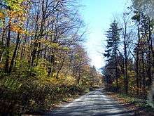
Forest Roads 104 and 112 are not maintained in the winter.[11] Impassable conditions can be expected any time from mid-October to mid-April.
Summit panorama
See also
References
- 1 2 3 "Spruce". NGS data sheet. U.S. National Geodetic Survey. Retrieved 2012-11-15.
- 1 2 "Spruce Knob, West Virginia". Peakbagger.com. Retrieved 2012-11-15.
- 1 2 Flint, Richard Foster; Skinner, Brian J. (1974). Physical Geography. ISBN 0471264407.
- ↑ Tilton, J.L.; Prouty, W.F.; Price, P.H. (1927). Pendleton County: West Virginia Geological Survey.
- ↑ "Spruce Knob and Spruce Knob Observation Tower". U.S. Forest Service. Retrieved 2014-02-13.
- ↑ Kenny, Hamill (1945). West Virginia Place Names: Their Origin and Meaning, Including the Nomenclature of the Streams and Mountains. Piedmont, WV: The Place Name Press. p. 597.
- ↑ Spruce Knob Lake Campground
- ↑ Spruce Knob and Spruce Knob Observation Tower
- ↑ "FR 104 road paving". U.S. Forest Service. 2001. Retrieved February 4, 2011.
- ↑ "FR 112 road paving". U.S. Forest Service. 2008. Retrieved February 4, 2011.
- ↑ "Monongahela National Forest: Hiking - Seneca Creek Backcountry & Gandy Creek Area". GORP. Retrieved February 4, 2011.