Altadena, California
| Altadena | |
|---|---|
| Census-designated place | |
|
Aerial view of Altadena and Eaton Canyon | |
 Location of Altadena in Los Angeles County, California | |
 Altadena Location in the United States | |
| Coordinates: 34°11′19″N 118°8′5″W / 34.18861°N 118.13472°WCoordinates: 34°11′19″N 118°8′5″W / 34.18861°N 118.13472°W | |
| Country |
|
| State |
|
| County |
|
| Area[1] | |
| • Total | 8.729 sq mi (22.609 km2) |
| • Land | 8.713 sq mi (22.566 km2) |
| • Water | 0.016 sq mi (0.043 km2) 0.19% |
| Elevation[2] | 1,358 ft (414 m) |
| Population (2010) | |
| • Total | 42,777 |
| • Density | 4,900/sq mi (1,900/km2) |
| Time zone | Pacific (UTC−8) |
| • Summer (DST) | PDT (UTC−7) |
| ZIP codes | 91001, 91003 |
| Area code(s) | 626 |
| FIPS code | 06-01290 |
| GNIS feature IDs | 1652662, 2407732 |

Altadena is an unincorporated[3] area[4] and census-designated place in Los Angeles County, California, United States, approximately 14 miles (23 km) from the downtown Los Angeles Civic Center, and directly north of the city of Pasadena, California. The population was 42,777 at the 2010 census, up from 42,610 at the 2000 census.
History
In the mid-1860s, Benjamin Eaton first developed water sources from the Arroyo Seco and Eaton Canyon to his vineyard near the edge of Eaton Canyon. This made possible the development of Altadena, Pasadena, and South Pasadena. He did the construction for B.D. Wilson and Dr. John Griffin, who jointly owned the Mexican land grant of Rancho San Pascual, about 14,000 acres (57 km2) that was the future sites of these three communities. They hoped to develop and sell this land in a real estate plan called the San Pasqual Plantation. Their efforts failed by 1870, despite Eaton's irrigation ditch that drew water from the site of present-day Jet Propulsion Laboratory in Arroyo Seco. They had failed because the land was relatively inaccessible and few believed crops could thrive that close to the mountains.
Eaton tried to sell the land for the partners, and in late 1873 he helped broker a deal with Daniel Berry, who represented a group of investors from Indiana, to buy 4,000 acres (16 km2) of the rancho. This included the land of present-day Altadena, but they developed a 2,500 acres (10 km2) section further south as Pasadena. In 1881, the land that would later become Altadena was sold to the John and Fred Woodbury, brothers who launched the subdivision of Altadena in 1887. The land remained mostly agricultural; however, several eastern millionaires built mansions along Mariposa Street, and a small community developed through the 1890s and into the next century.
| Historical population | |||
|---|---|---|---|
| Census | Pop. | %± | |
| 1960 | 40,568 | — | |
| 1970 | 42,415 | 4.6% | |
| 1980 | 40,983 | −3.4% | |
| 1990 | 42,658 | 4.1% | |
| 2000 | 42,610 | −0.1% | |
| 2010 | 42,777 | 0.4% | |
| sources:[5][6] | |||

In 1880, Capt. Frederick Woodbury, and his brother, John Woodbury of Marshalltown, Iowa, purchased 937 acres (3.79 km2) known as the Woodbury Ranch. John Woodbury established the Pasadena Improvement Company in 1887, with a plot plan of residential development referred to as the Woodbury Subdivision. They contacted Byron O. Clark, who established a nursery in the foothills in 1875, and had since moved away. He called his nursery "Altadena Nursery", a name he coined from the Spanish "alta" meaning "upper," and "dena" from Pasadena. Woodbury asked if he could use the name "Altadena" for his subdivision and Clark agreed.
The newly sprouted community of Altadena immediately began to attract millionaires from the East. In 1887 Andrew McNally, the printing magnate from Chicago, and his good friend Col. G. G. Green, had built mansions on what was to become Millionaire's Row; Mariposa Street near Santa Rosa Avenue. Newspaper moguls William Armiger Scripps and William Kellogg built homes side by side just east of Fair Oaks Avenue. A bit farther east, Zane Grey bought a home from Arthur Herbert Woodward, and added a second-floor study. The famous Benziger Publishing Company built a mansion on the corner of Santa Rosa Avenue (Christmas Tree Lane) and Mariposa. Mariposa was taken from the Spanish name for a butterfly. The grandson of Andrew McNally, Wallace Neff, became a famous Southern California architect. He started his career in Altadena with the design and construction of St. Elizabeth of Hungary Catholic Church (parish est.1918, which was dedicated in October 1926.
Over the years Altadena has been subject to attempted annexation by Pasadena. Annexation was stopped in 1956 by community campaigns, though it has been resurrected several times since by Pasadena without success. Had the annexation succeeded, Pasadena would be the 108th largest city in the United States.
While Altadena long refused wholesale annexation by neighboring Pasadena, the larger community nibbled at its edges in several small annexations of neighborhoods through the 1940s. With early 1960s redevelopment in Pasadena, the routing of extensions of 134 and 210 freeways, and lawsuits over the desegregation of Pasadena Unified School District, there was white flight and convulsive racial change in Altadena. In 1960, its black population was under four percent; over the next 15 years, half the Caucasian population left, and was replaced by people of color, many of whom settled on the west side of town after being displaced by Pasadena's redevelopment and freeway projects.
The name Altadena derives from the Spanish alta, meaning "upper", and dena from Pasadena; the area is adjacent to, but at a higher elevation than, Pasadena.[7]
Geography
According to the United States Census Bureau, the CDP has a total area of 8.7 square miles (23 km2), over 99% of it land.
Climate
Altadena experiences hot and dry summers that are followed by warm and windy falls. According to the Köppen Climate Classification system, Altadena has a hot-summer Mediterranean climate, abbreviated "Csa" on climate maps.
| Climate data for Altadena, California (1971–2000; extremes since 1927) | |||||||||||||
|---|---|---|---|---|---|---|---|---|---|---|---|---|---|
| Month | Jan | Feb | Mar | Apr | May | Jun | Jul | Aug | Sep | Oct | Nov | Dec | Year |
| Record high °F (°C) | 93 (34) |
92 (33) |
98 (37) |
105 (41) |
103 (39) |
110 (43) |
110 (43) |
107 (42) |
113 (45) |
108 (42) |
101 (38) |
93 (34) |
113 (45) |
| Average high °F (°C) | 67.8 (19.9) |
70.3 (21.3) |
71.3 (21.8) |
76.0 (24.4) |
78.2 (25.7) |
84.0 (28.9) |
89.4 (31.9) |
90.6 (32.6) |
88.5 (31.4) |
82.5 (28.1) |
73.8 (23.2) |
68.0 (20) |
78.4 (25.8) |
| Average low °F (°C) | 44.3 (6.8) |
45.9 (7.7) |
47.2 (8.4) |
50.0 (10) |
53.5 (11.9) |
57.4 (14.1) |
61.1 (16.2) |
62.0 (16.7) |
60.6 (15.9) |
55.2 (12.9) |
48.1 (8.9) |
44.1 (6.7) |
52.5 (11.4) |
| Record low °F (°C) | 19 (−7) |
15 (−9) |
23 (−5) |
31 (−1) |
32 (0) |
41 (5) |
45 (7) |
43 (6) |
41 (5) |
36 (2) |
26 (−3) |
21 (−6) |
15 (−9) |
| Average rainfall inches (mm) | 4.48 (113.8) |
5.00 (127) |
4.38 (111.3) |
1.22 (31) |
0.45 (11.4) |
0.21 (5.3) |
0.05 (1.3) |
0.21 (5.3) |
0.48 (12.2) |
0.65 (16.5) |
1.50 (38.1) |
2.46 (62.5) |
21.09 (535.7) |
| Average rainy days (≥ 0.01 inch) | 7.2 | 6.7 | 7.7 | 4.1 | 2.8 | 1.6 | 0.5 | 0.7 | 1.7 | 2.6 | 3.4 | 4.8 | 43.8 |
| Source #1: NOAA[8] | |||||||||||||
| Source #2: [9] | |||||||||||||
The wettest calendar year was 1983 with 48.47 inches (1,231.1 mm) and the driest 1947 with 5.37 inches (136.4 mm). The most rainfall in one month was 19.70 inches (500.4 mm) in February 1980. The most rainfall in 24 hours was 7.70 inches (195.6 mm) on March 2, 1938. Altadena averages 21.09 inches (535.7 mm) of rain a year, over 6 inches (150 mm) more than nearby Los Angeles due to the orographic effect created by the San Gabriel Mountains. Because of the slope on which the city is built, sewer lines in the city's northern section have been known to overflow significantly.
Demographics
2010
The 2010 United States Census[10] reported that Altadena had a population of 42,777. The population density was 4,900.4 people per square mile (1,892.1/km²). The racial makeup of Altadena was 22,569 (52.8%) White (40.3% Non-Hispanic White),[11] 10,136 (23.7%) African American, 300 (0.7%) Native American, 2,307 (5.4%) Asian, 71 (0.2%) Pacific Islander, 4,852 (11.3%) from other races, and 2,542 (5.9%) from two or more races. Hispanic or Latino of any race were 11,502 persons (26.9%).
The Census reported that 42,276 people (98.8% of the population) lived in households, 234 (0.5%) lived in non-institutionalized group quarters, and 267 (0.6%) were institutionalized.
There were 15,212 households, out of which 5,170 (34.0%) had children under the age of 18 living in them, 7,684 (50.5%) were opposite-sex married couples living together, 2,210 (14.5%) had a female householder with no husband present, 814 (5.4%) had a male householder with no wife present. There were 661 (4.3%) unmarried opposite-sex partnerships, and 271 (1.8%) same-sex married couples or partnerships. 3,489 households (22.9%) were made up of individuals and 1,318 (8.7%) had someone living alone who was 65 years of age or older. The average household size was 2.78. There were 10,708 families (70.4% of all households); the average family size was 3.26.
The age distribution of the city's population was as follows: 9,507 people (22.2%) were under the age of 18, 3,286 people (7.7%) aged 18 to 24, 10,622 people (24.8%) aged 25 to 44, 13,298 people (31.1%) aged 45 to 64, and 6,064 people (14.2%) who were 65 years of age or older. The median age was 41.8 years. For every 100 females there were 93.1 males. For every 100 females age 18 and over, there were 89.2 males.
There were 15,947 housing units at an average density of 1,826.8 per square mile (705.4/km²), of which 10,889 (71.6%) were owner-occupied, and 4,323 (28.4%) were occupied by renters. The homeowner vacancy rate was 0.9%; the rental vacancy rate was 4.9%. 30,319 people (70.9% of the population) lived in owner-occupied housing units and 11,957 people (28.0%) lived in rental housing units.
According to the 2010 United States Census, Altadena had a median household income of $82,895, with 10.7% of the population living below the federal poverty line.[11]
2000
As of the census[12] of 2000, there were 42,610 people, 14,780 households, and 10,671 families residing in the CDP. The population density was 4,898.9 people per square mile (1,891.0/km²). There were 15,250 housing units at an average density of 1,753.3 per square mile (676.8/km²). The racial makeup of the CDP was 47.30% White, 31.42% Black or African American, 0.58% Native American, 4.24% Asian, 0.13% Pacific Islander, 10.19% from other races, and 6.14% from two or more races. 20.39% of the population were Hispanic or Latino of any race.
There were 14,780 households out of which 34.1% had children under the age of 18 living with them, 52.3% were married couples living together, 15.2% had a female householder with no husband present, and 27.8% were non-families. 21.8% of all households were made up of individuals and 7.1% had someone living alone who was 65 years of age or older. The average household size was 2.82 and the average family size was 3.29.
In the CDP the population was spread out with 26.6% under the age of 18, 6.4% from 18 to 24, 30.1% from 25 to 44, 24.6% from 45 to 64, and 12.3% who were 65 years of age or older. The median age was 38 years. For every 100 females there were 91.8 males. For every 100 females age 18 and over, there were 86.6 males.
The median income for a household in the CDP was $60,549, and the median income for a family was $66,800 (these figures had risen to $77,020 and $86,778 respectively as of a 2007 estimate). Males had a median income of $49,098 versus $38,054 for females. The per capita income for the CDP was $27,604. About 7.4% of families and 10.6% of the population were below the poverty line, including 14.1% of those under age 18 and 8.3% of those age 65 or over.
Government and politics
Altadena is part of the County of Los Angeles and is politically run by the Los Angeles County Board of Supervisors who have executive, legislative and judicial powers. There are five members of the Board of Supervisors, elected by geographic district. Altadena is in District five, presently represented by Supervisor Michael D. Antonovich. In 1975, a group of Altadenans formed The Altadena Town Council with the help of Los Angeles County Supervisor Baxter Ward and the Pasadena Chapter of the League of Women Voters.
The Altadena Town Council acts as an ombudsman group to express to county, state and federal agencies the will and wishes of the Altadena community. Altadena is identified collectively by eight census tracts, (U.S. Census Bureau) from each of which two resident census tract representatives are elected. The Altadena Town Council meets monthly at the Altadena Community Center to provide a forum for residents and government officials to convene. The council has no legislative powers and makes no legal decisions for the community; it only operates to express consensus to governmental officials.
State and federal representation
In the California State Legislature, Altadena is in the 25th Senate District, represented by Democrat Anthony Portantino, and in the 41st Assembly District, represented by Democrat Chris Holden.[13]
In the United States House of Representatives, Altadena is in California's 27th congressional district, represented by Democrat Judy Chu.[14]
Infrastructure
The Los Angeles County Sheriff's Department (LASD) operates the Altadena Station in Altadena.[15]
The California Highway Patrol operates the Altadena Area Office on Windsor Dr. in Altadena.
Altadena is a shared jurisdiction where L.A. County Sheriff's Dept. handles crime-related calls and CHP handles traffic-related calls.
The Los Angeles County Department of Health Services operates the Monrovia Health Center in Monrovia, serving Altadena.[16]
Official tree and flower

Official tree: The Deodar Cedar (Cedrus deodara). Indigenous to the Himalayas, the deodar was brought as seeds to Altadena in 1883 by founder John Woodbury who saw the beautiful trees in Italy. After growing the trees for two years, the trees were transplanted to Santa Rosa Avenue where they now stand majestically as Christmas Tree Lane.
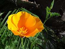
Official flower: The California Golden Poppy (Eschscholzia californica). Indigenous to the southland, the golden poppy was a landmark to Spanish sailors who recognized the area by a sweeping gold carpet. The sailors referred to the marvelous vision as sabanilla de oro, or, "altar cloth of gold."
Points of interest
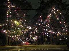
Christmas Tree Lane is a 0.7-mile (1.1 km) stretch of Santa Rosa Avenue from Woodbury Road to Altadena Drive. It has been a holiday attraction since 1920, and it is the oldest large-scale outdoor Christmas lighting venue in the world. Each December, members of the Christmas Tree Lane Association[17] festoon the 110 still standing giant deodars that line the street with thousands of Christmas lights. Christmas Tree Lane was placed on the National Register of Historic Places in 1990, and is a California Historical Landmark.
Among Altadena's Christmas lighting attractions is the Balian Mansion, which draws people worldwide for tours of its Christmas lighting display. The Balian Mansion has been lighted since 1955, and is arguably the pioneer of home holiday lighting. The Balian Mansion is located just east of Allen Avenue, at the 3-point junction of Mendocino Street, Mendocino Lane, and Glenview Terrace.
The historic Mount Lowe Railway was a scenic railway that once carried passengers to any of four resort hotels high in the San Gabriel Mountains above Altadena and Pasadena. Although the mountains and the remains of the railway are not strictly in Altadena, the most direct trail to the sites, the Sam Merrill Trail, starts in Altadena at the top of Lake Avenue, and leads to Mount Echo, about 3 miles (4.8 km). Chaney Trail, just west of the intersection at Fair Oaks Avenue and Loma Alta Street, is a forestry service road leading to the old right of way. The Mount Lowe Railway site was placed on the National Register of Historic Places in 1993.
For hiking enthusiast, Altadena is also home to a number of hiking trails, including the trail to the Dawn Mine, which can be reached via Chaney Trail to Sunset Ridge Trail. Arrows painted on large boulders direct hikers along the way.
The Cobb Estate at the top of Lake Avenue is now a free botanical garden, operated by the United States Forest Service. It is guarded by its historic gates, which are easily bypassed to allow visitors and hikers to ascend its long and winding paved driveway to the site of what was once one of Altadena's premier mansions. This site is also found alongside the Sam Merrill Trail, which accesses Las Flores Canyon on the way to Echo Mountain.
Farnsworth Park located on Lake Avenue is a large county park that offers picnic grounds, play areas, and a club house and amphitheater. It was placed in the National Register of Historic Places in 1997.
Education
Residents are zoned to Pasadena Unified School District schools. Zoned schools include Altadena Elementary School, Franklin Elementary School, Jackson Elementary School, Webster Elementary School, Aveson Charter Schools, Odyssey Charter School, Eliot Middle School, Muir High School, Pasadena High School, John Marshall Fundamental and Blair High School. Private schools include Sahag-Mesrob Armenian Christian School, St. Elizabeth Catholic School, Saint Mark's, Pasadena Waldorf School, and Fair Oaks Academy.
Notable people
- Nahshon Dion Anderson, award-winning writer, actor, model and Human Rights activist survived brutal assault at age 19[18]
- Aja Brown, Mayor, Compton, California
- Claude Akins, actor
- Al Boeke, architect and developer of Sea Ranch, California[19]
- Octavia Butler, author
- Andre Coleman, reporter and author
- Fannie Charles Dillon, composer
- Richard Feynman, physicist
- Rodney King, police brutality victim[20]
- Bob Lillis, Major League Baseball player and coach
- Paul Little, adult entertainment director and actor
- Mo Martin, LPGA golfer
- Jim Merritt, Major League Baseball pitcher
- Marni Nixon, singer
- Steve Sailer, author, blogger, and movie critic
- Michael Shermer, founder of The Skeptics Society and Editor in Chief of its magazine, Skeptic
- Adam Steltzner, spacecraft engineer
- Sharon Stouder, swimmer, three gold medals in 1964 Summer Olympics
- Meshach Taylor, Emmy-nominated actor, Designing Women
- Leslie Van Houten, Manson Family member serving life sentence for murder
- Mark Dean Veca, artist
- Alice Walker, author of The Color Purple
- Harold Zirin, solar astronomer, founder of Big Bear Solar Observatory
- Jirayr Zorthian, artist
- Dr. William Owen, Jr., OpNav for JPL
See also
References
- ↑ "2010 Census U.S. Gazetteer Files – Places – California". United States Census Bureau.
- ↑ "Altadena". Geographic Names Information System. United States Geological Survey. Retrieved October 19, 2014.
- ↑ Los Angeles County publication: "Unincorporated Areas within the County of Los Angeles", Altadena listed by Los Angeles County government office, as an unincorporated city, "Los Angeles County publication: 'Unincorporated Areas within the County of Los Angeles'", verified September 27, 2010
- ↑ Los Angeles County Office of Unincorporated Area Services, Altadena listed by Los Angeles County government office, as an unincorporated area, "Los Angeles County Office of Unincorporated Area Services", verified September 27, 2010
- ↑ "CENSUS OF POPULATION AND HOUSING (1790-2000)". U.S. Census Bureau. Archived from the original on July 8, 2010. Retrieved 2010-07-17.
- ↑ US Census Bureau
- ↑ Manning, Mike. The word Altadena was first used by Byron Clark, who coined it for his nursery located south of present-day Woodbury on the west side of town. When he moved his nursery to Linda Vista, he agreed to let the Woodburys take the name for their new subdivision. "ALTADENA, CALIFORNIA: an abbreviated history for the internet." Altadena Town Council. Retrieved on March 18, 2007.
- ↑ "Climatography of the United States No. 20: 1971-2000" (PDF). WRCC. Retrieved October 10, 2014.
- ↑ "Pasadena". WRCC. Retrieved June 17, 2010.
- ↑ "2010 Census Interactive Population Search: CA - Altadena CDP". U.S. Census Bureau. Retrieved July 12, 2014.
- 1 2 "State & County QuickFacts: Altadena CDP, California".
- ↑ "American FactFinder". United States Census Bureau. Archived from the original on September 11, 2013. Retrieved 2008-01-31.
- ↑ "Statewide Database". UC Regents. Retrieved December 8, 2014.
- ↑ "California's 27th Congressional District - Representatives & District Map". Civic Impulse, LLC.
- ↑ "Altadena Station." Los Angeles County Sheriff's Department. Retrieved on January 21, 2010.
- ↑ "Monrovia Health Center." Los Angeles County Department of Health Services. Retrieved on March 27, 2010.
- ↑ http://www.christmastreelane.net/
- ↑ "2016 Writers Retreat Fellows". Lambda Literary. Retrieved 2016-04-22.
- ↑ Hevesi, Dennis (2011-11-16). "Al Boeke, Architect Who Sought Ecological Harmony, Is Dead at 88". New York Times. Retrieved 2011-12-03.
- ↑ "Rodney King, L.A. police beating victim, dies". The San Francisco Chronicle. June 18, 2012.
Further reading
- The Altadena Historical Society
- Altadena Town Council
- Ives, Sarah Noble, Altadena. Pasadena, California: The Star-News Publishing Co., 1938. Out of print.
- Peterson, Robert H. Altadena's Golden Years. Alhambra, California: Sinclair Printing and Litho, Inc., 1976.
- Zack, Michele. Altadena: Between Wilderness and City. Altadena, California: Altadena Historical Society, 2004. ISBN 0-9747257-0-6
External links
| Wikimedia Commons has media related to Altadena, California. |
- Altadena Town Council
- Altadena Chamber of Commerce
- Altadena Historical Society
- Official Altadena Timeline
- Altadena Library District

Municipalities and communities of Los Angeles County, California, United States | ||
|---|---|---|
| Cities |
|  |
| CDPs |
| |
| Unincorporated communities |
| |
| Ghost towns |
| |