La Puente, California
| La Puente, California | ||
|---|---|---|
| City | ||
| City of La Puente | ||
|
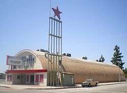
La Puente's Star Theater in May 2008 | ||
| ||
| Motto: Where the Past Meets the Future | ||
 Location of La Puente in Los Angeles County, California | ||
 La Puente, California Location in the United States | ||
| Coordinates: 34°1′57″N 117°57′19″W / 34.03250°N 117.95528°WCoordinates: 34°1′57″N 117°57′19″W / 34.03250°N 117.95528°W | ||
| Country |
| |
| State |
| |
| County |
| |
| Incorporated | August 1, 1956[1] | |
| Government | ||
| • Mayor | Violeta Lewis[2] | |
| Area[3] | ||
| • Total | 3.480 sq mi (9.012 km2) | |
| • Land | 3.479 sq mi (9.010 km2) | |
| • Water | 0.001 sq mi (0.002 km2) 0.02% | |
| Elevation | 351 ft (107 m) | |
| Population (2010) | ||
| • Total | 39,816 | |
| • Density | 11,000/sq mi (4,400/km2) | |
| Time zone | PST (UTC-8) | |
| • Summer (DST) | PDT (UTC-7) | |
| ZIP codes | 91744-91749[4] | |
| Area code | 626[5] | |
| FIPS code | 06-40340 | |
| GNIS feature IDs | 1660865, 2411581 | |
| City flower | Golden hibiscus | |
| City colors | Green and white | |
| Website |
www | |

La Puente is a city in Los Angeles County, California, United States. The population was 39,816 at the 2010 census. The city lies approximately 20 miles east of downtown Los Angeles.
History
The original inhabitants of the area now occupied by the city of La Puente were the Tongva. They lived in a village called Awingna, which linguists translate as "abiding place." The Awingna chief Matheo (who also held sway over several other nearby villages) was baptized at Mission San Gabriel in 1774.[6]
In 1769, the Spanish Portolà expedition became the first Europeans to see inland portions of Alta California. On July 30, the party camped on the east side of the San Gabriel River, in today's unincorporated area of Bassett. Father Juan Crespi wrote in his diary that, the next day, they had to build a bridge (Spanish "puente") to cross the miry San Gabriel River.[7]
With the establishment of Mission San Gabriel, the area encompassing Awingna and what is now the city of La Puente became part of Rancho La Puente, established as a mission outpost and ranch. The rancho was visited by the Jedediah Smith party in November 1826, the first Americans to travel overland to California.[8]
Following secularization of the missions in the 1830s, former mission ranchos passed into private ownership. In 1842, John Rowland and William Workman were granted the 48,000-acre (190 km2) Rancho La Puente. In 1884, the area was named Puente (bridge in Spanish; in old Spanish the noun was often feminine,[9] as opposed to modern Spanish el puente).
The area was known for its fruit and walnut groves during the 1930s. The city was even home to the world's largest walnut packing plant. Today, the city is heavily urbanized, but the area still has some historical landmarks from its founding days nearby, for instance, the Workman and Temple Family Homestead Museum in neighboring City of Industry.
Redevelopment of the business districts in La Puente have been ongoing. However, the local government has been relatively unsuccessful in its attempts to attract big-box retailers and restaurant chains. La Puente retains many aging 1950s-era strip malls.
Geography
La Puente is located at 34°1′57″N 117°57′19″W / 34.03250°N 117.95528°W (34.032410, -117.955195).[10] The city, which is mostly flat, covers about 3.5 square miles (9.1 km2) of land in the San Gabriel Valley.
Demographics
| Historical population | |||
|---|---|---|---|
| Census | Pop. | %± | |
| 1960 | 24,723 | — | |
| 1970 | 31,092 | 25.8% | |
| 1980 | 30,882 | −0.7% | |
| 1990 | 36,955 | 19.7% | |
| 2000 | 41,063 | 11.1% | |
| 2010 | 39,816 | −3.0% | |
| Est. 2015 | 40,745 | [11] | 2.3% |

2010
The 2010 United States Census[13] reported that La Puente had a population of 39,816. The population density was 11,443.2 people per square mile (4,418.2/km²). La Puente is 49.4% White (4.6% Non-Hispanic White), 1.4% Black or African American, 1.1% Native American, 8.4% Asian, and 0.1% Pacific Islander. Hispanic or Latino of any race were 33,896 persons (85.1%).[14]
The Census reported that 39,773 people (99.9% of the population) lived in households, 43 (0.1%) lived in non-institutionalized group quarters, and 0 (0%) were institutionalized.
There were 9,451 households, out of which 5,186 (54.9%) had children under the age of 18 living in them, 5,367 (56.8%) were opposite-sex married couples living together, 1,824 (19.3%) had a female householder with no husband present, 930 (9.8%) had a male householder with no wife present. There were 584 (6.2%) unmarried opposite-sex partnerships, and 65 (0.7%) same-sex married couples or partnerships. 989 households (10.5%) were made up of individuals and 472 (5.0%) had someone living alone who was 65 years of age or older. The average household size was 4.21. There were 8,121 families (85.9% of all households); the average family size was 4.34.
The population was spread out with 11,423 people (28.7%) under the age of 18, 4,640 people (11.7%) aged 18 to 24, 11,468 people (28.8%) aged 25 to 44, 8,619 people (21.6%) aged 45 to 64, and 3,666 people (9.2%) who were 65 years of age or older. The median age was 31.5 years. For every 100 females there were 99.7 males. For every 100 females age 18 and over, there were 97.8 males.
There were 9,761 housing units at an average density of 2,805.3 per square mile (1,083.1/km²), of which 5,693 (60.2%) were owner-occupied, and 3,758 (39.8%) were occupied by renters. The homeowner vacancy rate was 1.0%; the rental vacancy rate was 3.9%. 24,961 people (62.7% of the population) lived in owner-occupied housing units and 14,812 people (37.2%) lived in rental housing units.
According to the 2010 United States Census, La Puente had a median household income of $53,794, with 14.3% of the population living below the federal poverty line.[14]
2000
As of the census of 2000, there are 41,063 people, 9,461 households, and 8,183 families residing in the city. The population density is 4,542.8/km² (11,757.3/mi²). There are 9,660 housing units at an average density of 1,068.7/km² (2,765.9/mi²). The racial makeup of the city is 39.11% White, 1.96% African American, 1.28% Native American, 7.16% Asian, 0.17% Pacific Islander, 45.14% from other races, and 5.19% from two or more races. 83.10% of the population are Hispanic or Latino of any race.
There are 9,461 households out of which 50.0% have children under the age of 18 living with them, 60.4% are married couples living together, 17.9% have a female householder with no husband present, and 13.5% are non-families. 10.1% of all households are made up of individuals and 4.4% have someone living alone who is 65 years of age or older. The average household size is 4.34 and the average family size is 4.48.
In the city the population is spread out with 33.8% under the age of 18, 11.6% from 18 to 24, 31.0% from 25 to 44, 15.9% from 45 to 64, and 7.7% who are 65 years of age or older. The median age is 28 years. For every 100 females there are 100.1 males. For every 100 females age 18 and over, there are 98.8 males.
The median income for a household in the city is $41,222, and the median income for a family is $41,079. Males have a median income of $26,381 versus $22,018 for females. The per capita income for the city is $11,336. 18.9% of the population and 16.3% of families are below the poverty line. Out of the total people living in poverty, 24.6% are under the age of 18 and 9.3% are 65 or older.
Government
In the California State Legislature, La Puente is in the 22nd Senate District, represented by Democrat Ed Hernandez, and in the 57th Assembly District, represented by Democrat Ian Calderon.[15]
In the United States House of Representatives, La Puente is in California's 32nd congressional district, represented by Democrat Grace Napolitano.[16]
Infrastructure
The Los Angeles County Sheriff's Department operates the Industry Station in the City of Industry, serving La Puente.[17]
The Los Angeles County Department of Health Services operates the Pomona Health Center in Pomona, serving La Puente.[18]
The Los Angeles County Fire Department operates the following fire Stations: Fire Station 26 Fire Station 43
Both Fire Stations 26 and 43 are members of the LACOFD Battalion 12. Battalion 12 consists of the cities of Rowland Heights, La Puente, La Mirada, Industry and Hacienda Heights.
Economy
The income per capita of the city of La puente is $16,899, which includes all children and adults. The city's median household income is $62,709.
Top employers
According to the City's 2013 Comprehensive Annual Financial Report,[19] the top employers in the city are:
| # | Employer | # of Employees |
|---|---|---|
| 1 | Northgate González Markets | 120 |
| 2 | Bodega Latina Corp (El Super) | 80 |
| 3 | Food 4 Less | 75 |
| 4 | Ed Butts Ford | 70 |
| 5 | Big Saver Foods | 60 |
| 6 | Merritt’s Ace Hardware | 43 |
| 7 | Burger King | 37 |
| 8 | CVS/Pharmacy | 35 |
| 9 | 99 Cents Only Stores | 32 |
| 10 | Jack in the Box | 32 |
Education
School districts include:
- Hacienda La Puente Unified School District
- Bassett Unified School District
- Rowland Unified School District
Elementary (primary) schools: Lassalette Elementary School, Sparks Elementary School
High (secondary) schools: Bassett High School, La Puente High School, Nogales High School, William Workman High School (in the City of Industry)
Private high schools: Bishop Amat Memorial High School
Notable people
- Alfie Agnew - mathematician, songwriter and musician
- Sutan Amrull - make-up artist and performer
- Tony Baltazar - professional boxer (former resident)
- Eric Bieniemy - UCLA and NFL running back, attended Bishop Amat HS
- Anthony Calvillo - record-breaking Canadian Football League quarterback
- Cecil Fielder - former Nogales High School and Detroit Tigers slugger, father of Prince Fielder
- Jeff Garcia - voice actor and comedian; voice for the character Sheen Estevez in The Adventures of Jimmy Neutron: Boy Genius
- Norberto Garrido - lineman for the NFL's Carolina Panthers
- Pat Haden - former USC and NFL quarterback, attended Bishop Amat HS
- Dan Haren - MLB pitcher, attended Bishop Amat HS
- Efren Herrera - UCLA and NFL kicker, attended La Puente HS
- Mike Lamb - MLB infielder, attended Bishop Amat HS
- Billy Laughlin - "Froggy" from the Our Gang comedies
- Darryll Lewis - Arizona and NFL cornerback, attended Nogales HS
- Steven Luevano - professional boxer
- Lionel Manuel - U of Pacific and NFL wide receiver, attended Bassett HS
- Arturo Marquez - renowned composer of orchestra music (former resident)
- Crispin Castro Monroy - municipal president of Santa Cruz Atizapan
- Max Montoya - UCLA and NFL offensive lineman, attended La Puente HS
- William R. Rowland - Los Angeles County sheriff
- John Sciarra - UCLA and NFL quarterback, attended Bishop Amat HS
- Hilda Solis - politician, member of Los Angeles County Board of Supervisors for District 1
- Michael Young - 7-time All-Star infielder in Major League Baseball, attended Bishop Amat HS
- David Denson - First professional baseball player affiliated with an MLB organization to come out as gay
References
- ↑ "California Cities by Incorporation Date" (Word). California Association of Local Agency Formation Commissions. Retrieved August 25, 2014.
- ↑ "Mayro & City Council". Retrieved February 23, 2015.
- ↑ "2010 Census U.S. Gazetteer Files – Places – California". United States Census Bureau.
- ↑ "USPS - ZIP Code Lookup - Find a ZIP+ 4 Code By City Results". Retrieved 2007-01-18.
- ↑ "Number Administration System - NPA and City/Town Search Results". Retrieved 2007-01-18.
- ↑ http://www.laokay.com/halac/RanchoLaPuente.htm
- ↑ Bolton, Herbert E. (1927). Fray Juan Crespi: Missionary Explorer on the Pacific Coast, 1769-1774. HathiTrust Digital Library. p. 144. Retrieved April 2014. Check date values in:
|access-date=(help) - ↑ Smith, J. S., & Brooks, G. R. (1977). The Southwest expedition of Jedediah S. Smith: His personal account of the journey to California, 1826-1827, p.96. Glendale, Calif: A. H. Clark Co. ISBN 0870621238
- ↑ "Diccionario de la Real Académia Española." Online edition.
- ↑ "US Gazetteer files: 2010, 2000, and 1990". United States Census Bureau. 2011-02-12. Retrieved 2011-04-23.
- ↑ "Annual Estimates of the Resident Population for Incorporated Places: April 1, 2010 to July 1, 2015". Retrieved July 2, 2016.
- ↑ "Census of Population and Housing". Census.gov. Retrieved June 4, 2015.
- ↑ "2010 Census Interactive Population Search: CA - La Puente city". U.S. Census Bureau. Retrieved July 12, 2014.
- 1 2 http://quickfacts.census.gov/qfd/states/06/0640340.html. Missing or empty
|title=(help) - ↑ "Statewide Database". UC Regents. Retrieved November 24, 2014.
- ↑ "California's 32nd Congressional District - Representatives & District Map". Civic Impulse, LLC.
- ↑ "Industry Station." Los Angeles County Sheriff's Department. Retrieved on January 21, 2010.
- ↑ "Pomona Health Center." Los Angeles County Department of Health Services. Retrieved on March 27, 2010.
- ↑ "City of La Puente CAFR" (PDF). Retrieved 2014-08-13.
External links
- Official website
- Regional Chamber of Commerce - San Gabriel Valley
- City Data: La Puente, California
- LA County Disaster Communications Service ( DCS ) Industry Sheriff Station

 |
South El Monte | West Covina | West Covina | |
| Avocado Heights | |
West Covina | ||
| ||||
| | ||||
| Industry | Industry & Hacienda Heights | Industry & Rowland Heights |