Monrovia, California
| Monrovia, California | ||
|---|---|---|
| City | ||
| City of Monrovia | ||
|
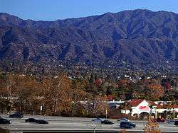
I-210 in Monrovia with San Gabriel Mountains in the background. | ||
| ||
 Location of Monrovia in Los Angeles County, California. | ||
 Monrovia, California Location in the United States | ||
| Coordinates: 34°8′45.28″N 118°0′3.42″W / 34.1459111°N 118.0009500°WCoordinates: 34°8′45.28″N 118°0′3.42″W / 34.1459111°N 118.0009500°W | ||
| Country |
| |
| State |
| |
| County |
| |
| Incorporated | December 15, 1887[1] | |
| Government | ||
| • City council |
Mayor Tom Adams Mayor Pro Tem Larry J. Spicer Alexander C. Blackburn Gloria Crudgington Becky A. Shevlin | |
| • City Treasurer | Stephen Baker[2] | |
| Area[3] | ||
| • Total | 13.714 sq mi (35.519 km2) | |
| • Land | 13.605 sq mi (35.237 km2) | |
| • Water | 0.109 sq mi (0.282 km2) 0.79% | |
| Elevation | 571 ft (174 m) | |
| Population (April 1, 2010)[4] | ||
| • Total | 36,590 | |
| • Estimate (2013)[4] | 37,101 | |
| • Density | 2,700/sq mi (1,000/km2) | |
| Time zone | PST (UTC-8) | |
| • Summer (DST) | PDT (UTC-7) | |
| ZIP codes | 91016, 91017 | |
| Area code | 626 | |
| FIPS code | 06-48648 | |
| GNIS feature ID | 1661049 | |
| Website |
www | |

Monrovia is a city located in the foothills of the San Gabriel Mountains in the San Gabriel Valley of Los Angeles County, California, United States. The population was 36,590 at the 2010 census, down from 36,929 in 2000. Monrovia has been used for filming TV shows, movies and commercials.
History

Monrovia is the fourth oldest general law city in Los Angeles County and the L.A. Basin (after Los Angeles, Santa Monica, and Pasadena). Incorporated in 1887, Monrovia has grown from a sparse community of orange ranches to a residential community of 37,000.
Around 500 BC, a band of Shoshonean-speaking Indians named the Tongva established settlements in what is now the San Gabriel Valley. They were called the Gabrieliño Indians by early Spanish missionaries, a tribe of Mission Indians. The Tongva were not farmers; they gathered wild seeds, berries, and plants along rivers and in marshlands. Abundant oaks in the Valley, such as Coast Live Oak and Interior Live Oak provided a staple of the Tongva diet: acorn mush made of boiled acorn flour.
In 1769, the Portolà expedition was the first recorded Spanish (or any European) land entry and exploration of present-day California, then the Spanish colonial Las Californias Province of the Viceroyalty of New Spain (colonial México). It had been claimed from sea by Juan Rodríguez Cabrillo in 1542 for the King of Spain, Europeans first visited the San Gabriel Valley, including Monrovia. The expedition, led by Gaspar de Portolà, proceeded north from San Diego, passing through the area en route to Monterey Bay. Accompanying Portolà was Franciscan padre Juan Crespí, famed diarist of the expedition. Much of what is known of early California is from Crespi's detailed descriptions.
In 1771, the Franciscans established the Mission San Gabriel Arcangel in the San Gabriel Valley. The mission continued after Mexican independence in 1822. In 1833, the Mexican Congress initiated secularization of the missions in Alta California, to begin seizure of mission properties for sale to private rancho grantees.
In 1841, Alta California Governor Juan Alvarado issued Mexican land grants for Rancho Azusa de Duarte to Andres Duarte, a Mexican soldier; and for Rancho Santa Anita to Hugo Reid, a naturalized Mexican citizen of Scottish birth. Monrovia is made of parts of these two ranchos.
In the mid-19th century, most of Rancho Azusa de Duarte was subdivided and sold by Duarte to settle his debts. Some of those parcels became part of the ranch of William N. Monroe, Monrovia's namesake.
Rancho Santa Anita changed hands several times before the multimillionaire, silver baron and rancher, E.J. "Lucky" Baldwin acquired it in 1875. That same year his Los Angeles Investment Company began subdividing and selling parcels from many of his ranchos. In 1883, 240 acres (970,000 m²) of Rancho Santa Anita were sold to Monroe for $30,000. Additional parcels of Rancho Santa Anita were sold to Edward F. Spence, John D. Bicknell, James F. Crank, and J.F. Falvey.
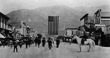
The completion of the Los Angeles and San Gabriel Valley Railroad in 1887, later sold to the Santa Fe, (which would run through Monrovia), and Southern Pacific railroads to Southern California would bring new people looking for homes and investment opportunities. With this in mind, Monroe, Spence, Bicknell, Crank, and Falvey combined their land under the business name of the Monrovia Land and Water Company in 1886, centered at Orange (now Colorado Boulevard) and Myrtle Avenues; the first tract extended from Magnolia Avenue on the west to Charlotte Avenue (Canyon Boulevard) on the east, a half block south of Walnut on the south and a half block north of Lime on the north.[5] The subdivision was subdivided into 600 500-foot (150 m) by 160-foot (49 m) lots and sold.
The town was incorporated in 1887 under the leadership of prohibitionists who wished to control the arrival of an unwelcome saloon. The first order of business for the newly formed government was to pass a tippler's law, prohibiting the sale of alcohol.
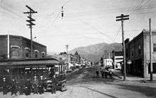
In 1903 the Monrovia News was established. In the same year, the Pacific Electric was opened providing transportation to and from Los Angeles, making it possible for Monrovian homeowners to work in Los Angeles.
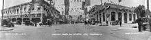
In 1905 Carnegie funds became available and with the help of the Board of Trade (forerunner to the Chamber of Commerce), and the Monrovia Women's Club, a bond issue was passed to purchase the Granite Bank Building to be used as a City Hall, and to acquire property for a public park. The Granite Building serves as the city hall, fire and police department facilities in 1961 and the fire department in 1974. In 1956, the old Carnegie library building was torn down and a new library was constructed. In March 2007, a new library was voted on by the people of Monrovia. It won with 70% yes votes. The library now has 190,000 books, a heritage room for historical documents, and areas for children, teens, and adults.[6]
A city council-manager type government was instituted in 1923.
Monrovia was the home to the precursor to McDonald's. In 1937, Patrick McDonald opened a food stand on Huntington Drive (Route 66) near the old Monrovia Airport called "The Airdrome" (hamburgers were ten cents, and all-you-can-drink orange juice was five cents); it remained there until 1940, when he and his two sons, Maurice and Richard, moved the building 40 miles (64 km) east to San Bernardino to the corner of West 14th Street and 1398 North E Street, renaming it "McDonald's". (The oldest McDonald's restaurant still in operation is in Downey, California, which opened in 1953.)
The Upton Sinclair House, home to activist and author Upton Sinclair, is located in Monrovia and is a National Historic Landmark. In 1995, Monrovia received the All America City Award from the National Civic League.
Geography
According to the United States Census Bureau, the city has a total area of 35.5 square kilometers (13.7 sq mi). 13.6 square miles (35 km2) of it is land and 0.1 square miles (0.26 km2) of it (0.79%) is water.
Demographics
| Historical population | |||
|---|---|---|---|
| Census | Pop. | %± | |
| 1890 | 907 | — | |
| 1900 | 1,205 | 32.9% | |
| 1910 | 3,576 | 196.8% | |
| 1920 | 5,480 | 53.2% | |
| 1930 | 10,890 | 98.7% | |
| 1940 | 12,807 | 17.6% | |
| 1950 | 20,186 | 57.6% | |
| 1960 | 27,079 | 34.1% | |
| 1970 | 30,562 | 12.9% | |
| 1980 | 30,531 | −0.1% | |
| 1990 | 35,761 | 17.1% | |
| 2000 | 36,929 | 3.3% | |
| 2010 | 36,590 | −0.9% | |
| Est. 2015 | 37,463 | [7] | 2.4% |
2010
The 2010 United States Census[9] reported that Monrovia had a population of 36,590. The population density was 2,668.1 people per square mile (1,030.2/km²). The racial makeup of Monrovia was 21,932 (59.9%) White (41.1% Non-Hispanic White),[10] 4,107 (11.2%) Asian, 2,500 (6.8%) African American, 279 (0.8%) Native American, 76 (0.2%) Pacific Islander, 5,818 (15.9%) from other races, and 1,878 (5.1%) from two or more races. Hispanic or Latino of any race were 14,043 persons (38.4%).
The census reported that 36,434 people (99.6% of the population) lived in households, 61 (0.2%) lived in non-institutionalized group quarters, and 95 (0.3%) were institutionalized.
There were 13,762 households, out of which 4,725 (34.3%) had children under the age of 18 living in them, 6,295 (45.7%) were opposite-sex married couples living together, 2,073 (15.1%) had a female householder with no husband present, 778 (5.7%) had a male householder with no wife present. There were 793 (5.8%) unmarried opposite-sex partnerships, and 131 (1.0%) same-sex married couples or partnerships. 3,649 households (26.5%) were made up of individuals and 1,276 (9.3%) had someone living alone who was 65 years of age or older. The average household size was 2.65. There were 9,146 families (66.5% of all households); the average family size was 3.24.
The population was spread out with 8,514 people (23.3%) under the age of 18, 3,084 people (8.4%) aged 18 to 24, 10,733 people (29.3%) aged 25 to 44, 10,018 people (27.4%) aged 45 to 64, and 4,241 people (11.6%) who were 65 years of age or older. The median age was 37.9 years. For every 100 females there were 91.6 males. For every 100 females age 18 and over, there were 87.0 males.
There were 14,473 housing units at an average density of 1,055.4 per square mile (407.5/km²), of which 6,809 (49.5%) were owner-occupied, and 6,953 (50.5%) were occupied by renters. The homeowner vacancy rate was 1.3%; the rental vacancy rate was 4.9%. 18,478 people (50.5% of the population) lived in owner-occupied housing units and 17,956 people (49.1%) lived in rental housing units.
According to the 2010 United States Census, Monrovia had a median household income of $71,768, with 9.8% of the population living below the federal poverty line.[10]
2000
As of the census[11] of 2000, there were 36,929 people, 13,502 households, and 9,086 families residing in the city. The population density was 2,686.5 inhabitants per square mile (1,037.0/km²). There were 13,957 housing units at an average density of 1,015.3 per square mile (391.9/km²). The racial makeup of the city was 62.92% White, 8.67% African American, 7.02% Asian, 0.87% Native American, 0.13% Pacific Islander, 15.61% from other races, and 4.77% from two or more races. Hispanic or Latino of any race were 35.24% of the population.
There were 13,502 households out of which 35.4% had children under the age of 18 living with them, 46.4% were married couples living together, 15.4% had a female householder with no husband present, and 32.7% were non-families. 26.0% of all households were made up of individuals and 8.8% had someone living alone who was 65 years of age or older. The average household size was 2.71 and the average family size was 3.29.
In the city the age distribution of the population shows 27.4% under the age of 18, 8.0% from 18 to 24, 34.0% from 25 to 44, 20.2% from 45 to 64, and 10.4% who were 65 years of age or older. The median age was 34 years. For every 100 females there were 92.2 males. For every 100 females age 18 and over, there were 87.6 males.
The median income for a household in the city was $45,375, and the median income for a family was $49,703. Males had a median income of $41,039 versus $32,259 for females. The per capita income for the city was $21,686. About 9.7% of families and 13.1% of the population were below the poverty line, including 18.3% of those under age 18 and 9.7% of those age 65 or over.
Government and infrastructure
In the California State Legislature, Monrovia is in the 25th Senate District, represented by Democrat Anthony Portantino, and in the 41st Assembly District, represented by Democrat Chris Holden.[12]
In the United States House of Representatives, Monrovia is split between California's 27th congressional district, represented by Democrat Judy Chu, and California's 32nd congressional district, represented by Democrat Grace Napolitano.[13]
The Los Angeles County Department of Health Services operates the Monrovia Health Center in Monrovia.[14]
Education
Public schools

Monrovia Unified School District operates public schools.
Monrovia High School was built in 1887. It was located where Monroe School now stands, and housed the entire elementary and high school student body. A new high school on the property now occupied by Clifton Middle School was erected in 1905, and in 1912 was greatly expanded by the addition of new buildings. In 1928 a high school to serve the communities of Monrovia, Arcadia and Duarte was built. The same structure now serves only Monrovia students, as the elementary and high school district were unified into one district in 1961. The district now has one high school, one continuation school, two middle schools and five elementary schools.
The city's public schools are:
- Bradoaks Elementary School, K-5, 930 E. Lemon
- Canyon Early Learning Center, public pre-K, 1000 South Canyon
- Canyon Oaks High School (public alternative), 7-12, 930 Royal Oaks Drive
- Clifton Middle School, 6-8, 226 S. Ivy
- Mayflower Elementary School, K-5, 210 North Mayflower
- Monroe Elementary School, K-5, 402 W. Colorado
- Monrovia Community Adult School 920 South Mountain
- Monrovia High School 9-12, 845 W. Colorado Boulevard
- Monrovia Mountain School, public Alternative K-8, 950 S. Mountain Avenue
- Plymouth Elementary K-5, 1300 Boley Street
- Santa Fe Middle School 6-8, 148 W. Duarte Road
- Serendipity Early Care and Education Center, K, 940 W. Duarte Road
- Wild Rose Elementary, A California Distinguished School K-5, 232 Jasmine
- Vista Ridge Academy, 1311S. Shamrock
Private schools
- Calvary Road Baptist Academy, K-12, 319 W. Olive
- Church of the Nazarene, K-6 303 W. Colorado
- First Lutheran School, pre-K-8, 1323 South Magnolia
- First Presbyterian Church Preschool, 101 E. Foothill Blvd.
- Immaculate Conception School, K-8, 726 Shamrock
Lycée International de Los Angeles previously had its San Gabriel Valley campus in Monrovia. It opened in 1990 on the property of the United Methodist Church.[15] Its area campus is now in Pasadena. It moved to Pasadena in July 2006.[16]
Miscellaneous education
- Joe Ferrante Music Academy, K-12, 126 E. Colorado Blvd.
Colleges and universities
Mt Sierra College is an accredited bachelor's degree granting institution, located at 101 E Huntington Dr. The city is a part of the Citrus Community College District.
Media
Monrovia community news are provided by the San Gabriel Valley Tribune, and Monrovia Weekly which is a weekly community newspaper. Public access television is provided by KGEM-TV, which is available only to cable viewers.
Transportation
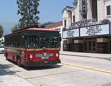
Monrovia main roads include Foothill Boulevard and Huntington Drive (historic Route 66). It is also served by the Foothill Freeway (I-210).
In 2016, Metro opened a new at grade light rail station in Monrovia called Monrovia Station. It is located at the intersection of Myrtle Avenue and Duarte Road, and is served by the Metro Gold Line.[17] It is at the same location of the former Santa Fe Depot, which still stands.
Economy
Original Tommy's, Trader Joe's, Green Dot and Naked Juice are based in Monrovia. Monrovia has a "Technology Corridor,[18] " which includes AeroVironment, Tanner Research, Parasoft, Xencor, and ITT Deep Space Division.
Top employers
According to the city's 2010 Comprehensive Annual Financial Report,[19] the top employers in the city are:
| # | Employer | # of employees |
|---|---|---|
| 1 | Monrovia Unified School District | 489 |
| 2 | Ducommun AeroStructures | 463 |
| 3 | WorleyParsons | 452 |
| 4 | The Home Depot | 364 |
| 5 | Oracle | 315 |
| 6 | AeroVironment | 267 |
| 7 | Vinyl Technology | 251 |
| 8 | City of Hope | 250 |
| 9 | ITT Systems | 240 |
| 10 | City of Monrovia | 240 |
Trivia
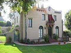
- The house seen in the 1986 horror-comedy cult film House (1986 film) is located at 329 Melrose Avenue in Monrovia.[20]
Notable people
- Kenny Baker, singer and actor
- Dicky Barrett, frontman, Mighty Mighty Bosstones, late night TV announcer
- Mary Ford, vocalist and guitarist
- Jim Fuller, guitarist for The Surfaris (of "Wipeout" fame)
- Prince Gomolvilas, playwright
- Dean R. Hirsch, president of World Vision International
- Ellis McCarthy, Defensive tackle for Miami Dolphins
- Corky King, founder of Summum
- Scott Land, puppeteer/actor
- Francis M. Pottenger, Jr., nutrition researcher
- Upton Sinclair and Mary Craig Sinclair, authors and producers
- Jacob Smith, actor
- William A. Spinks (1865–1933), champion carom billiards pro, co-inventor of modern billiards cue chalk, oil investor, and flower and avocado farmer (developer of the Spinks avocado cultivar); also maintained a home and farm in nearby Duarte
- The Fabulous Wonder Twins, entertainers
- Jason Earles, actor, Hannah Montana, Kickin' It
- Richard Ramirez, serial killer, once killed people there
See also
Notes
- ↑ "California Cities by Incorporation Date" (Word). California Association of Local Agency Formation Commissions. Retrieved August 25, 2014.
- ↑ California League of Cities, Elected City Treasurers Archived February 12, 2012, at the Wayback Machine.
- ↑ "2010 Census U.S. Gazetteer Files – Places – California". United States Census Bureau.
- 1 2 "Monrovia (city) QuickFacts". United States Census Bureau. Retrieved April 16, 2015.
- ↑ http://www.cityofmonrovia.org/sites/default/files/fileattachments/community_development/page/1457/wildrose_historic_context.pdf
- ↑ "Monrovia Public Library — Monrovia Patch — Patch.com". Monrovia.patch.com. 2011-01-27. Retrieved July 2013. Check date values in:
|access-date=(help) - ↑ "Annual Estimates of the Resident Population for Incorporated Places: April 1, 2010 to July 1, 2015". Retrieved July 2, 2016.
- ↑ "Census of Population and Housing". Census.gov. Retrieved June 4, 2015.
- ↑ "2010 Census Interactive Population Search: CA - Monrovia city". U.S. Census Bureau. Retrieved July 12, 2014.
- 1 2 http://quickfacts.census.gov/qfd/states/06/0648648.html. Missing or empty
|title=(help) - ↑ "American FactFinder". United States Census Bureau. Retrieved 2008-01-31.
- ↑ "Statewide Database". Regents of the University of California. Retrieved March 31, 2015.
- ↑ "Communities of Interest - City". California Citizens Redistricting Commission. Retrieved September 27, 2014.
- ↑ "Monrovia Health Center." Los Angeles County Department of Health Services. Retrieved on March 27, 2010.
- ↑ Klein, Karen E. "Monrovia Will Get a Taste of France With New School" (Archive). Los Angeles Times. June 20, 1990. Retrieved on June 29, 2015.
- ↑ "Pasadena Campus." Lycée International de Los Angeles. Retrieved on June 29, 2015.
- ↑ Archived June 19, 2004, at the Wayback Machine.
- ↑ "Technology Corridor". Cityofmonrovia.ws. Retrieved July 2013. Check date values in:
|access-date=(help) - ↑ "City of Monrovia CAFR" (PDF). Retrieved July 2013. Check date values in:
|access-date=(help) - ↑ "Film locations for House (1986)". Movie-locations.com. Retrieved July 2013. Check date values in:
|access-date=(help)
References
Luis Rodriguez, Captain of the Notorious Mafia Oak Tree Gang.
External links
| Wikimedia Commons has media related to Monrovia, California. |
 |
San Gabriel Mountains | San Gabriel Mountains | Bradbury | |
| Arcadia | |
Duarte | ||
| ||||
| | ||||
| North El Monte | El Monte | Baldwin Park |
