Monterey Park, California
| Monterey Park, California | ||
|---|---|---|
| General law city[1] | ||
| City of Monterey Park | ||
|
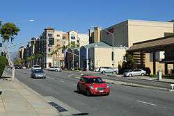
A busy section of Atlantic Boulevard | ||
| ||
| Motto: Pride in the Past, Faith in the Future | ||
 Location of Monterey Park in Los Angeles County, California | ||
 Monterey Park, California Location in the United States | ||
| Coordinates: 34°2′57″N 118°8′8″W / 34.04917°N 118.13556°WCoordinates: 34°2′57″N 118°8′8″W / 34.04917°N 118.13556°W | ||
| Country |
| |
| State |
| |
| County |
| |
| Incorporated | May 29, 1916[2] | |
| Government | ||
| • Type | Council-Manager[1] | |
| • City council[3] |
Peter Chan Mitchell Ing Teresa Real Sebastian Stephen Lam Hans Liang | |
| Area[4] | ||
| • Total | 7.733 sq mi (20.029 km2) | |
| • Land | 7.672 sq mi (19.870 km2) | |
| • Water | 0.061 sq mi (0.158 km2) 0.79% | |
| Elevation[5] | 384 ft (117 m) | |
| Population (April 1, 2010)[6] | ||
| • Total | 60,269 | |
| • Estimate (2013)[6] | 61,085 | |
| • Density | 7,800/sq mi (3,000/km2) | |
| Time zone | Pacific Time Zone (UTC-8) | |
| • Summer (DST) | PDT (UTC-7) | |
| ZIP codes | 91754-91756 | |
| Area code | 323, 626 | |
| FIPS code | 06-48914 | |
| GNIS feature IDs | 1652753, 2411146 | |
| Website |
www | |
Monterey Park is a city in Los Angeles County, California, United States, 8 miles (13 km) east of Downtown Los Angeles. The city's motto is "Pride in the past, Faith in the future".[7] Monterey Park is part of a cluster of cities (Alhambra, Arcadia, Temple City, Rosemead, San Marino, and San Gabriel in the west San Gabriel Valley) with a growing Asian American population, making up 66.9% of its resident population at 2010; 47.7% of its residents are of Chinese descent, the largest concentration of Chinese Americans of any municipality in the United States.[8] According to the 2010 Census, the city had a total population of 60,269.[7]
History
Early history
For at least seven thousand years[9] the land was populated by the Tongva (Gabrielino) Native Americans. The Tongva lived in dome like structures with thatched exteriors, an open smoke hole for ventilation and light at the top.[10] Both sexes wore long hair styles and tattooed their bodies. During warm weather the men wore little clothes but the women would wear minimal skirts made of animal hides. During the cold weather they would wear animal skin capes and occasionally wore sandals made from hide of yucca fiber.[11] With the arrival of the Spaniards, Old World diseases killed off many of the Tongva, and by 1870 very few Native-Americans had survived. In the early 19th century the area was part of the Mission San Gabriel Arcángel mission system and later, the Rancho San Antonio.
1860s–1960s
Following the Civil War, an Italian, Alessandro Repetto, purchased 5,000 acres (20 km2) of the rancho and built his ranch house on the hill overlooking his land, about a half-mile north of where Garfield Avenue crosses the Pomona Freeway,[12] not far from where the Edison substation is now located on Garfield Avenue.[13]
It was at this time, Richard Garvey, a mail rider for the U.S. Army whose route took him through Monterey Pass, a trail that is now Garvey Avenue, settled down in the King's Hills. Garvey began developing the land by bringing in spring water from near the Hondo River and by constructing a 54-foot-high (16 m) dam to form Garvey Lake located where Garvey Ranch Park is now. To pay for his development and past debts, Garvey began selling portions of his property. In 1906, the first subdivision in the area, Ramona Acres (named after the developer's daughter, who would also later inspire the title of the novel Ramona[14]), was developed north of Garvey and east of Garfield Avenues.[13]
In 1916, the new residents of the area initiated action to become a city when the cities of Pasadena, South Pasadena, and Alhambra proposed to put a large sewage treatment facility in the area. The community voted itself into cityhood on May 29, 1916, by a vote of 455 to 33. The City's new Board of Directors immediately outlawed sewage plants within city boundaries and named the new city Monterey Park. The name was taken from an old government map showing the oak-covered hills of the area as Monterey Hills. In 1920, a large area on the south edge of the city broke away and the separate city of Montebello was established.[15]
By 1920, the white and Spanish-surname settlers were joined by Asian residents who began farming potatoes and flowers and developing nurseries in the Monterey Highlands area. They improved the Monterey Pass Trail with a road to aid in shipping their produce to Los Angeles. The nameless pass, which had been a popular location for western movies, was called Coyote Pass by Pioneer Masami Abe.[13]
In 1926, near the corner of Atlantic and Garvey Avenue, Laura Scudder invented the first sealed bag of potato chips. In an effort to maintain quality and freshness, Laura's team would iron sheets of wax paper together to form a bag. They would fill these bags with potato chips; iron the top closed, and then deliver them to various retailers.[16]

Real estate became a thriving industry during the late 1920s with investors attracted to the many subdivisions under development and increasing commercial opportunities. One such development was the Midwick View Estates by Peter N. Snyder, a proposed garden community that was designed to rival Bel Air and Beverly Hills. Known as the "Father of the East Side", Mr. Snyder was a key player in the vast undertaking in the 1920s of developing the East Side as part of the industrial base of Los Angeles. His efforts to build Atlantic Boulevard, his work with the East Side organization to bring industry to the East Side, and his residential and commercial development projects along Atlantic Boulevard (Gardens Square, Golden Gate Square, and the Midwick View Estates) were a major influence to the surrounding communities. The focal point of the Midwick View Estates was "Jardin del Encanto", otherwise known as "El Encanto," a Spanish style building that was to serve as the administration building and community center for Midwick View Estates, and an amphitheater to be nestled into the hillside above Kingsford Street. Although the amphitheater was never built, the observation terrace from which viewers could look down to Jardin del Encanto and the fountain with cascading water going down the hillside in stepped pools to De La Fuente remains and is now known as Heritage Falls Park or "the Cascades." The Great Depression brought an abrupt end to the real estate boom, as well as the Midwick proposal. From the late 1920s, the City had little development for nearly two decades.[13]
The end of World War II resulted in a revived growth trend with explosive population gains during the late 1940s and 1950s. Until this time, the population was concentrated in the northern and southern portions of the city, with the Garvey and Monterey Hills forming a natural barrier. With the renewed growth, many new subdivisions were developed, utilizing even the previously undeveloped central area to allow for maximum growth potential. A series of annexations of surrounding land also occurred.[13]
1970s–1990s
Beginning in the 1970s, well-educated and affluent Asian Americans began settling in the west San Gabriel Valley, primarily to Monterey Park.[17] The city council subsequently tried and failed to pass English-only ordinances.[18][19] In 1985 the City Council of Monterey Park approved drafting of a proposal that would require all businesses in Monterey Park to display English language identification on business signs.[20]
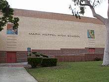
In the 1980s, Monterey Park was also referred to as "Little Taipei" or affectionately, "The Chinese Beverly Hills" by a local Chinese-language newspaper, "Asian Week".[21][22][23] Frederic Hsieh, a local realtor who bought land in Monterey Park and sold it to newly arrived immigrants, is credited with engendering Monterey Park's Chinese American community. [24][25] Many businesses from the Chinatown in downtown LA began to open up stores in Monterey Park. In the 1970s and 1980s, many affluent waisheng ren Taiwanese immigrants moved abroad from Taiwan and began settling into Monterey Park. Mandarin Chinese dialect was predominant in the city during that time.[26] In 1983, Lily Lee Chen became the first Chinese American woman to be elected mayor of a U.S. city.[27] By the late 1980s, immigrants from Mainland China and Vietnam began moving into Monterey Park. By the 1990 census, Monterey Park became the first city with an Asian descent majority population in the continental United States.[23] Timothy P. Fong, a professor and director of Asian American studies at California State University, Sacramento, describes Monterey Park as the "First Suburban Chinatown".[26] In the 1980s, the second generation Chinese Americans generally moved out of the old Chinatown and into the San Gabriel Valley suburbs, joining the new immigrants from Taiwan and Mainland China.[28] From that time, with a combined influx of Vietnamese, Taiwanese and Hong Kong immigrant students at the time, Mark Keppel High School, constructed during the New Deal era and located in Alhambra, but also serving most of Monterey Park and portions of Rosemead, felt the impact of this new immigration as the student population increased dramatically, leading to overcrowding.[29] Today, many students are second- or third-generation Asian Americans.[30] In the Japanese community called: Nisei, (second-generation), Sansei, (third-generation).[31]
In 1988, the City of Monterey Park passed an ordinance declaring a moratorium on new building, in an attempt to regulate the rapid growth the city experienced as a result of the influx of Asian immigrants.[22] [32] This moratorium was challenged and defeated in 1989[33] This controversial move caused many Asian residents and businesses to shift focus, establishing themselves in the neighboring city of Alhambra. When the potential loss of business revenue was recognized,[34] "Monterey Park went through a lot of upheaval that a lot of people regret."[35] and relocation back to Monterey Park was highly encouraged in the Asian American community.[36]
Since early 1990s, the Taiwanese are no longer the majority in the city,[23] and Mandarin, the national language of China, is now rapidly displacing Cantonese as the most widely spoken dialect in many Chinese businesses of Monterey Park. Cantonese, a dialect from southern China has dominated the Chinatowns of North America for decades, but Mandarin is the most common language of the latest Chinese immigrants.[37][38] The construction boom of shopping centers had declined, but plans for redevelopment sought to change that. High property values and overcrowding in Monterey Park[39] have contributed to a secondary movement away from Monterey Park.
2000s-present
Redevelopment produced several projects included the massive Atlantic Times Square development that opened in 2010 with ground-floor shops and restaurants.[40] The Atlantic Times Square,[41] which has 215,000 square feet (20,000 m2), is anchored by AMC Theatres and 24 Hour Fitness, in addition to eating establishments and other stores. The development includes 210 condos on the third through sixth floors.[42]
Monterey Park Village is a 40,000 sq. ft. shopping center on South Atlantic Boulevard commercial corridor. Tenants include: Staples, Walgreens and Togo’s eatery.[42] The CVS Center on South Garfield Avenue is a redevelopment of infill site into a 17,000 square feet (1,600 m2) neighborhood convenience center. Anchor tenant CVS Pharmacy brings a full-service drug store back to the downtown project,[42] and the center includes a Subway sandwich shop.[42] The 507,000-square-foot (47,100 m2) Cascades Market Place will be the largest shopping center in the city. Located along the Pomona (60) Freeway west of Paramount Boulevard, this center proposes to be a major regional shopping center for the San Gabriel Valley. This 45 plus acre project has great grade level visibility from the freeway.[43]
Business

The Chinese-dominated business district, near the intersection of Garfield Avenue and Garvey Avenue, is called "Downtown Monterey Park".[44] In the mid-1980s, Lincoln Plaza Hotel was built to predominately service tourists from Taiwan and Hong Kong. Monterey Park has many choices of Hong Kong fusion cafes, there are several Cantonese seafood restaurants, as well as restaurants offering Mainland Chinese fare. A variety of cuisine can be found throughout the city.
Top employers
According to the City's 2010 Comprehensive Annual Financial Report,[45] the top employers in the city are:
| # | Employer | # of Employees |
|---|---|---|
| 1 | East Los Angeles College | 1,969 |
| 2 | Garfield Medical Center | 970 |
| 3 | Los Angeles County Sheriff's Department | 791 |
| 4 | Superior Court of Los Angeles County - Edmund D. Edelman Children's Court | 736 |
| 5 | City of Monterey Park | 440 |
| 6 | Monterey Park Hospital | 362 |
| 7 | Care1st Health Plan | 315 |
| 8 | Southern California Gas Company | 279 |
| 9 | AT&T | 228 |
| 10 | SynerMed | 217 |
| 11 | Ralphs | 158 |
| 12 | First Data | 133 |
| 13 | California Highway Patrol | 131 |
| 14 | World Journal | 128 |
| 15 | Southern California Edison | 125 |
| 16 | Camino Real Chevrolet | 121 |
| 17 | CVS/pharmacy | 117 |
Places of interest
Monterey Park is home to the Garvey Ranch Observatory, located in Garvey Ranch Park, which is operated by the Los Angeles Astronomical Society (LAAS). It adjoins a historical museum, a classroom, and a workshop. The observatory houses an 8-inch (200 mm) refractor, a telescope making workshop, and a library containing over 1000 books. The grounds are open to the public for free astronomical observation on Wednesday evenings from 7:30PM – 10:00PM, hosted by LAAS members.[46]
East Los Angeles College is located along the southern boundary of the City. The college has undergone a large-scale renovation.
Built in 1929, Jardin El Encanto, otherwise known as "El Encanto", is a Spanish-style building located at 700 El Mercado. El Encanto is home to beautiful tile and hand painted woodwork. The building, originally the sales office for Midwick Estates, was once a USO center and speakeasy.
The City invested in the renovation of this beautiful structure which has significant historic value to the community.
Transportation
Monterey Park is served by the Long Beach Freeway, (I-710), the San Bernardino Freeway (I-10), and the Pomona Freeway, SR 60.
Public transportation is provided by the city government, Spirit bus service and Metrolink feeder bus, the City of Montebello and the Los Angeles County Metropolitan Transportation Authority. Metro Gold Line light rail service stops at Atlantic station just south of the city limits.
Geography
Monterey Park is located at 34°02′57″N 118°08′08″W / 34.049199°N 118.135561°W.[47] According to the United States Census Bureau, the city has a total area of 7.7 square miles (20 km2), of which, 7.6 square miles (20 km2) is land, and 0.04 square miles (0.10 km2) (0.39%) is water.
The city boundaries include Los Angeles to the west, unincorporated East Los Angeles to the south and west, Alhambra to the north, Rosemead to the northeast, Montebello to the south, and unincorporated South San Gabriel to the southeast.
Demographics
| Historical population | |||
|---|---|---|---|
| Census | Pop. | %± | |
| 1920 | 4,108 | — | |
| 1930 | 6,406 | 55.9% | |
| 1940 | 8,531 | 33.2% | |
| 1950 | 20,395 | 139.1% | |
| 1960 | 37,821 | 85.4% | |
| 1970 | 49,166 | 30.0% | |
| 1980 | 54,338 | 10.5% | |
| 1990 | 60,738 | 11.8% | |
| 2000 | 60,051 | −1.1% | |
| 2010 | 60,269 | 0.4% | |
| Est. 2015 | 61,468 | [48] | 2.0% |
2010
The 2010 United States Census[50] reported that Monterey Park had a population of 60,269. The population density was 7,793.7 people per square mile (3,009.2/km²). The racial makeup of Monterey Park was 40,301 (66.9%) Asian (47.7% Chinese, 5.8% Japanese, 4.4% Vietnamese, 1.9% Filipino, 1.3% Korean, 0.9% Thai, 0.8% Cambodian, 0.4% Burmese, 0.4% Indonesian, 0.3% Indian), 28 (0.05%) Pacific Islander, 11,680 (19.4%) White (5.0% Non-Hispanic White),[51] 252 (0.4%) African American, 242 (0.4%) Native American, 6,022 (10.0%) from other races, and 1,744 (2.9%) from two or more races. Hispanic or Latino of any race were 16,218 persons (26.9%).
The Census reported that 60,039 people (99.6% of the population) lived in households, 41 (0.1%) lived in non-institutionalized group quarters, and 189 (0.3%) were institutionalized.
There were 19,963 households, out of which 6,315 (31.6%) had children under the age of 18 living in them, 10,538 (52.8%) were opposite-sex married couples living together, 3,243 (16.2%) had a female householder with no husband present, 1,460 (7.3%) had a male householder with no wife present. There were 651 (3.3%) unmarried opposite-sex partnerships, and 85 (0.4%) same-sex married couples or partnerships. 3,641 households (18.2%) were made up of individuals and 2,025 (10.1%) had someone living alone who was 65 years of age or older. The average household size was 3.01. There were 15,241 families (76.3% of all households); the average family size was 3.37.
The population was spread out with 10,932 people (18.1%) under the age of 18, 5,180 people (8.6%) aged 18 to 24, 15,597 people (25.9%) aged 25 to 44, 16,904 people (28.0%) aged 45 to 64, and 11,656 people (19.3%) who were 65 years of age or older. The median age was 43.1 years. For every 100 females there were 92.2 males. For every 100 females age 18 and over, there were 89.4 males.
There were 20,850 housing units at an average density of 2,696.2 per square mile (1,041.0/km²), of which 11,058 (55.4%) were owner-occupied, and 8,905 (44.6%) were occupied by renters. The homeowner vacancy rate was 0.5%; the rental vacancy rate was 4.1%. 33,073 people (54.9% of the population) lived in owner-occupied housing units and 26,966 people (44.7%) lived in rental housing units.
According to the 2010 United States Census, Monterey Park had a median household income of $56,014, with 15.2% of the population living below the federal poverty line.[51]
2009
According to the 2009 American Community Survey, Monterey Park is 43.7% Chinese American, and is the city in the United States with the largest concentration of people of Chinese descent.[52] The Chinese American population in Monterey Park and San Gabriel Valley is relatively diverse in socio-economics and region of origin. The city has attracted immigrants from Taiwan, as well as Mainland Chinese and the overseas Chinese from Southeast Asia. There are also significant Japanese, Vietnamese, Korean, and Filipino communities living within Monterey Park.
While the multi-generational American-born Latino population was generally declining in Monterey Park, there has been a small new influx of Mexican immigrants (about one percent increase in the population).[53][54]
2000
There were 19,564 households out of which 31.3% had children under the age of 18 living with them, 55.4% were married couples living together, 15.8% had a female householder with no husband present, and 22.1% were non-families. 17.3% of all households were made up of individuals and 8.7% had someone living alone who was 65 years of age or older. The average household size was 3.06 and the average family size was 3.43.[55]
In the city the population was spread out with 21.3% under the age of 18, 8.4% from 18 to 24, 30.2% from 25 to 44, 22.2% from 45 to 64, and 17.9% who were 65 years of age or older. The median age was 38 years. For every 100 females there were 92.4 males. For every 100 females age 18 and over, there were 89.3 males.
The median income for a household in the city was $40,724, and the median income for a family was $43,507. Males had a median income of $32,463 versus $29,057 for females. The per capita income for the city was $17,661. About 12.4% of families and 15.6% of the population were below the poverty line, including 22.6% of those under age 18 and 9.2% of those age 65 or over.
These were the ten neighborhoods in Los Angeles County with the largest percentage of Asian residents, according to the 2000 census:[56]
- Chinatown, 70.6%
- Monterey Park, 61.1%
- Cerritos, 58.3%
- Walnut, 56.2%
- Rowland Heights, 51.7%
- San Gabriel, 48.9%
- Rosemead, 48.6%
- Alhambra, 47.2%
- San Marino, 46.8%
- Arcadia, 45.4%
Government
_01.JPG)
In the state legislature Monterey Park is located in the 22nd Senate District, represented by Democrat Ed Hernandez, and in the 49th Assembly District, represented by Democrat Ed Chau.
In the United States House of Representatives, Monterey Park is in California's 27th congressional district, represented by Democrat Judy Chu.[57] Chu previously served as mayor and city council member of Monterey Park.
City
The city of Monterey Park has its own police and fire departments serving the city.
Monterey Park City Municipal Elections are held every two years in odd numbered years, on the first Tuesday in March. Five Council Members serve four year terms with overlapping terms in bi-annual elections: the three seats elected in one election and two seats in the next election, at which time the City Clerk and City Treasurer are also elected.[58]
The current elected officials are:
- Peter Chan, Mayor[3]
- Mitchell Ing, Mayor Pro-Tem[3]
- Teresa Real Sebastian, Council Member[3]
- Stephen Lam, Council Member[3]
- Hans Liang, Council Member[3]
- Vincent D. Chang, City Clerk
- Joseph Leon, City Treasurer
County services
The Los Angeles County Sheriff's Department has its central headquarters in Monterey Park. Los Angeles County Sheriff's Department[59] The Edmund D. Edelman Children's Court, Sybil Brand Institute, Central Juvenile District, (Dependency) is located in Monterey Park.[60] The Los Angeles County Department of Health Services operates the Monrovia Health Center in Monrovia, serving Monterey Park.[61]
Education
Colleges and universities
East Los Angeles College is a community college that is located in Monterey Park in an area that was once part of East Los Angeles (unincorporated). In addition California State University, Los Angeles is in proximity.[62]
Primary and secondary schools
Four school districts all serve different areas of Monterey Park. They include Alhambra Unified School District, Garvey School District, Los Angeles Unified School District, and Montebello Unified School District.[62][63]
Public schools
Alhambra Unified School District

K-8 schools serving AUSD in Monterey Park include:
- Brightwood School
- Monterey Highlands School
- Repetto School
- Ynez School
Mark Keppel High School, , located in Alhambra, also serves Monterey Park.
Garvey School District
Two elementary schools, Hillcrest and Monterey Vista (both are in Monterey Park), serve this part of the city. Monterey Vista is a Blue Ribbon School.
Garvey Intermediate School (Rosemead) also serves this portion.
Once students graduate from eighth grade, they attend Alhambra's Mark Keppel High School .
Los Angeles Unified School District
Robert Hill Lane Elementary School (Monterey Park), Griffith Middle School (Unincorporated Los Angeles County), and Garfield High School (Unincorporated Los Angeles County) serve the LAUSD part of the city.
Montebello Unified School District
Bella Vista Elementary School, Monterey Park, Potrero Heights Elementary School, South San Gabriel, Macy Intermediate School, Monterey Park, and Schurr High School, Montebello, serve the Montebello MUSD portion.
Private schools
Saint Stephen Martyr School: opened in 1926 to provide the families of Monterey Park with an opportunity for their children to receive a Catholic School education. K–Grade 8 [64]
Meher Montessori School: preschool, lower and upper elementary classes[65]
St Thomas Aquinas School: A Catholic parish school, serving economically and ethnically diverse students in grades Kindergarten through eighth. Founded in 1963, the Church is in the center of our school both physically and spiritually. The school is accredited by the Western Association of Schools and Colleges and the Western Catholic Educational Association.[66]
New Avenue School PreKindergarten—Kindergarten through 8th grade. New Avenue school was founded in 1961. [67]
Alpha-Shen Preschool and Kindergarten
Esther's Nest Children's School Pre-Kindergarten—Kindergarten
Graceland Christian Day Care Center Pre-Kindergarten—Kindergarten
Monterey Park Christian School Pre-Kindergarten—Kindergarten
Public library
The Monterey Park Bruggemeyer Library serves Monterey Park.[68]
Media
Monterey Park community news is covered by the San Gabriel Valley Tribune.
Notable people
- Judy Chu, Congresswoman from California's 27th district and former City Councilwoman
- Ernest "Red" Hallen, official photographer of the Panama Canal.
- Dan Haren, starting pitcher for the St. Louis Cardinals, Oakland Athletics, Arizona Diamondbacks, Los Angeles Dodgers and Miami Marlins
- William Hung, rejected American Idol contestant, current statistical analyst for the Los Angeles County Sheriff’s Department[69]
- Saladin McCullough, NFL player
- Esther Salas, the first Hispanic woman to serve as a United States magistrate judge in the District of New Jersey, and the first Hispanic woman to be appointed a U.S. District Court judge in New Jersey.[70]
- Roberta Shore, actress
- Michael Woo, former Los Angeles City Councilman (1985–1994) and Dean of the Cal Poly Pomona College of Environmental Design
See also
References
- 1 2 "Term of Office". Monterey Park, CA. Retrieved February 10, 2015.
- ↑ "California Cities by Incorporation Date" (Word). California Association of Local Agency Formation Commissions. Retrieved August 25, 2014.
- 1 2 3 4 5 6 "City Council". Monterey Park, CA. Retrieved March 26, 2015.
- ↑ "2010 Census Gazetteer Files - Places - California". United States Census Bureau. Retrieved March 26, 2015.
- ↑ "Monterey Park". Geographic Names Information System. United States Geological Survey. Retrieved October 16, 2014.
- 1 2 "Monterey Park (city) QuickFacts". United States Census Bureau. Retrieved March 19, 2015.
- 1 2 http://www.ci.monterey-park.ca.us/
- ↑ "PACS | Asian Pacific Family Center | Asian Youth Center | Chinatown Service Center | Korean Youth and Community Center | Search to Involve Pilipino Americans". Pacsla.org. 2005-04-26. Retrieved 2010-08-17.
- ↑ "introduction". Lausd.k12.ca.us. Retrieved 2010-08-17.
- ↑ "Housing". Lausd.k12.ca.us. Retrieved 2010-08-17.
- ↑ "clothing". Lausd.k12.ca.us. Retrieved 2010-08-17.
- ↑ "About Montebello". City of Montebello. 1920-10-19. Retrieved 2010-08-17.
- 1 2 3 4 5 "City of Monterey Park : History of Monterey Park". Ci.monterey-park.ca.us. Retrieved 2010-08-17.
- ↑ Cecilia, Rasmussen (January 17, 1994). "L.A. Scene / The City Then and Now". Los Angeles Times. Retrieved July 19, 2011.
- ↑ "Chamber History". Montebellochamber.org. Retrieved 2010-08-17.
- ↑ "Laura Scudder's". Laurascudders.com. Retrieved 2010-08-17.
- ↑ Horton, John. The Politics of Diversity: Immigration, Resistance, and Change in Monterey Park, California . Temple University Press, 195. p. 80.Chapter 4
- ↑ Kirsch, Jonathan (February 7, 2001). "A Chronicle of Triumph, Pain in Chinese American Community". Los Angeles Times. Retrieved 18 January 2016.
- ↑ https://web.archive.org/web/20100609165853/http://asianweek.com/052496/LittleTaipei.html. Archived from the original on June 9, 2010. Retrieved November 11, 2010. Missing or empty
|title=(help) - ↑ Arax, Mark. "Stronger Rules on English in Signs Pushed by Council." Los Angeles Times. December 5, 1985. 1. Retrieved on March 29, 2010.
- ↑ http://asianweek.com/052496/LittleTaipei.html
- 1 2 Alfred Pong. "The Chinese Beverly Hills". Asianweek.com. Retrieved 2010-08-17.
- 1 2 3 "Monterey Park, California (CA) @USA". At-usa.com. Retrieved 2010-08-17.
- ↑ http://www.nytimes.com/1999/08/20/us/frederic-hsieh-is-dead-at-54-made-asian-american-suburb.html
- ↑ ["http://www.nytimes.com/1999/08/20/us/frederic-hsieh-is-dead-at-54-made-asian-american-suburb.html" "http://www.nytimes.com/1999/08/20/us/frederic-hsieh-is-dead-at-54-made-asian-american-suburb.html"] Check
|url=value (help). Missing or empty|title=(help) - 1 2 Fong, Timothy P. (1994). The First Suburban Chinatown. Temple University. ISBN 978-1-56639-262-4.
- ↑ Shyong, Frank (February 24, 2015) "Monterey Park nears a demographic milestone, yet race rarely discussed" Los Angeles Times
- ↑ San Gabriel Valley Tribune Archived March 14, 2012, at the Wayback Machine.
- ↑ "Mark Keppel High School". Mkhs.org. 1999-12-31. Retrieved 2010-08-17.
- ↑ http://www.hks.harvard.edu/aapr/doc/tsai76-98.pdf
- ↑ "Diabetes and diabetes risk factors in second- and third-generation Japanese Americans in Seattle, Washington". Diabetes Res. Clin. Pract. 24 Suppl: S43–52. October 1994. PMID 7859632.
- ↑ "Local News in Brief : Building Bans Imposed - Los Angeles Times". Articles.latimes.com. 1988-05-12. Retrieved 2010-08-17.
- ↑ Berton, Justin (2010-06-05). "Whites in state 'below the replacement' level". Sfgate.com. Retrieved 2010-08-17.
- ↑ http://www.docstoc.com/docs/48018067/The-First-Suburban-Chinatown
- ↑ Quan, Douglas. "Some in Chino Hills nervous about ethnic shift." The Press-Enterprise. Tuesday February 6, 2007. Retrieved on January 21, 2010.
- ↑ DOUGLAS QUANThe Press-Enterprise (2007-02-06). "Riverside County | PE.com | Southern California News | News for Inland Southern California". PE.com. Retrieved 2010-08-17.
- ↑ Semple, Kirk (2009-10-22). "In Chinatown, Sound of the Future Is Mandarin". The New York Times.
- ↑ http://www.howardwfrench.com/archives/2006/01/07/cantonese_is_losing_its_voice_speakers_of_the_spicy_tongue_that_can_make_words_of_love_sound_like_a_fight_are_having_to_learn_its_linguistic_kin_the_mellower_mandarin/
- ↑ http://www.ci.monterey-park.ca.us/index.aspx?page=726
- ↑ Hawthorne, Christopher (May 13, 2012) "Atlantic on the move" Los Angeles Times
- ↑ Atlantic Times Square
- 1 2 3 4 http://www.ci.monterey-park.ca.us/Index.aspx?page=286
- ↑ http://www.ci.monterey-park.ca.us/index.aspx?page=1284
- ↑ http://www.ci.monterey-park.ca.us/index.aspx?page=1811
- ↑ City of Monterey Park CAFR
- ↑ "Garvey Ranch". Retrieved 2011-08-10.
- ↑ "US Gazetteer files: 2010, 2000, and 1990". United States Census Bureau. 2011-02-12. Retrieved 2011-04-23.
- ↑ "Annual Estimates of the Resident Population for Incorporated Places: April 1, 2010 to July 1, 2015". Retrieved July 2, 2016.
- ↑ "Census of Population and Housing". Census.gov. Retrieved June 4, 2015.
- ↑ "2010 Census Interactive Population Search: CA - Monterey Park city". U.S. Census Bureau. Retrieved July 12, 2014.
- 1 2 "Monterey Park (city) QuickFacts". United States Census Bureau.
- ↑ http://www.asian-nation.org/taiwanese.shtml
- ↑ http://factfinder.census.gov/servlet/SAFFFacts?_event=Search&_geoContext=&_street=&_county=monterey+park&_cityTown=monterey+park&_state=04000US06&_zip=&_lang=en&_sse=on&pctxt=fph&pgs1=010&show_2003_tab=&redirect=Y
- ↑ http://factfinder.census.gov/servlet/ACSSAFFFacts?_event=&geo_id=16000US0648914&_geoContext=01000US|04000US06|16000US0648914&_street=&_county=monterey+park&_cityTown=monterey+park&_state=04000US06&_zip=&_lang=en&_sse=on&ActiveGeoDiv=&_useEV=&pctxt=fph&pgsl=160&_submenuId=factsheet_1&ds_name=DEC_2000_SAFF&_ci_nbr=null&qr_name=null®=&_keyword=&_industry=
- ↑ http://www.laalmanac.com/cities/ci56.htm
- ↑ "Asian", Mapping L.A., Los Angeles Times
- ↑ "California's 27th Congressional District - Representatives & District Map". Civic Impulse, LLC.
- ↑ http://www.ci.monterey-park.ca.us/index.aspx?page=3
- ↑ "Education-Based Discipline." Los Angeles County Sheriff's Department. April 29, 2009. Retrieved on March 12, 2010.
- ↑ "Court Location General Tab". Lasuperiorcourt.org. Retrieved 2010-08-17.
- ↑ "Monrovia Health Center." Los Angeles County Department of Health Services. Retrieved on March 27, 2010.
- 1 2 "School districts serving Monterey Park." City of Monterey Park. Retrieved on July 3, 2010.
- ↑ http://www.latimes.com/classified/realestate/news/la-re-guide5mar05,1,4455622.story latimes.com
- ↑ St. Stephen Martyr School
- ↑ "info". Mehermontessori.org. Retrieved 2010-08-17.
- ↑ "Information - St. Thomas Aquinas Catholic School". Stacatholicschool.org. Retrieved 2010-08-17.
- ↑ New Avenue School
- ↑ "" Monterey Park Bruggemeyer Library. Retrieved on June 13, 2013.
- ↑ Transparent California 2011
- ↑ Sanabria, Santo. "Local roots". The Union City Reporter. July 24, 2011. pages 1 and 12
Further reading
- Saito, Leland T. Race and Politics: Asian Americans, Latinos, and Whites in a Los Angeles Suburb. University of Illinois Press, 1980. ISBN 0-252-06720-7, ISBN 978-0-252-06720-4.
External links
| Wikivoyage has a travel guide for Monterey Park. |
| Wikimedia Commons has media related to Monterey Park, California. |
- Official website
- Monterey Park Bruggemeyer Library
- Monterey Park Chamber of Commerce
- The First Suburban Chinatown
- Asian American History and Culture, edited by Sucheng Chan, David Palumbo-Liu, Michael Omi, K. Scott Wong, and Linda Trinh Võ.
 |
El Sereno | Alhambra | Rosemead | |
| East Los Angeles | |
Rosemead | ||
| ||||
| | ||||
| East Los Angeles | Montebello | South San Gabriel |
