California State Route 39
| ||||
|---|---|---|---|---|
 | ||||
| Route information | ||||
| Defined by Streets and Highways Code § 339 | ||||
| Maintained by Caltrans | ||||
| Length: |
50.017 mi[1] (80.495 km) SR 39 is broken into pieces due to an unconstructed portion, and the length does not reflect the gap. | |||
| Existed: | 1934[2] – present | |||
| Section 1 | ||||
| South end: |
| |||
| Major junctions: |
| |||
| North end: | Whittier Ave, Harbor Blvd in La Habra | |||
| Section 2 | ||||
| South end: |
| |||
| Major junctions: |
| |||
| North end: |
| |||
| Highway system | ||||
| ||||

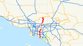
State Route 39 (SR 39) is a state highway in the U.S. state of California that travels through Orange and Los Angeles counties. Its southern terminus is at Pacific Coast Highway (SR 1), in Huntington Beach. SR 39's northern terminus is at Islip Saddle on Angeles Crest Highway (SR 2) in the Angeles National Forest, but its northernmost 4.5-mile (7.2 km) segment (including the connection with SR 2) has been closed to the public since 1978 due to a massive mud and rockslide.
Route description
This route is part of the California Freeway and Expressway System[3] and is eligible for the State Scenic Highway System.[4] However, it is not a scenic highway as designated by Caltrans.[5]

State Route 39 runs along Beach Boulevard through most of Orange County, with the exception of the segment between Interstate 5 and the southern city limit of Buena Park, which was relinquished to the city in 2013. At Beach Boulevard's northerly terminus, Whittier Boulevard, Route 39 turns east to the intersection of Whittier Boulevard with Harbor Boulevard, taking over a former segment of Route 72. Route 72 remains on Whittier Boulevard west of Beach Boulevard.
Although defined to be a continuous route, there is a break in adopted Route 39 at the intersection of Whittier Boulevard with Harbor Boulevard, where an "END 39" sign appears. The California Streets and Highways Code defines the continuation of Route 39 as "Harbor Boulevard to the vicinity of Fullerton Road, then to Azusa Avenue" through southern Rowland Heights.
The planned alignment of Route 39 continues its northward progress on Azusa Avenue (CR N8) to the northwest in Hacienda Heights. Adopted Route 39 resumes and signs for Route 39 appear on Azusa Avenue after the junction with the San Bernardino Freeway, Interstate 10 in West Covina. The adopted route continues for 1.0-mile (1.6 km) to the Covina/West Covina city limit, 0.1-mile (0.16 km) north of Grovecenter Street.
From 0.1-mile (0.16 km) north of Grovecenter Street to the north limit of Azusa, 0.7-mile (1.1 km) northeast of Rock Springs Way, previously adopted Route 39 has been relinquished (to the cities of Covina and Azusa). However, to aid motorists wishing to continue on Route 39, California Route 39 shields remain through the relinquished area. It is noted that the portion of Route 39 within West Covina was relinquished to that city in accordance with Section 339 of the California Streets and Highways Code in 2005. In the city of Azusa from just north of Interstate 210 to just north of Sierra Madre Ave. Former Route 39 is a couplet (composed of two one-way streets): northbound traffic is on Azusa Ave.; southbound traffic is on San Gabriel Ave.
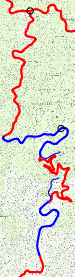
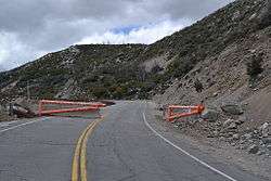
At the north limit of Azusa, adopted Route 39 begins again as San Gabriel Canyon Road. Route 39 winds through the San Gabriel Mountains in the Angeles National Forest for 21.9 miles (35.2 km) until it reaches a gate barring the road 1.8 miles (2.9 km) north of Crystal Lake Road in the Crystal Lake Recreation Area. The last four and one-half miles of the route, including the connection to Route 2, are closed to public highway traffic, as the roadbed has been closed since 1978, due to major rockslides that year and again in 2005 which damaged more of the remaining roadbed.
A replacement of the section north of East Fork Road, in the next canyon to the east, was partly built in 1936 and 1961, but was never completed. The section includes one bridge and two tunnels; it was never used by automobile or truck traffic. In one local hiking guide the section is identified as the "Road to Nowhere" and the "Convict Road", although the official name is the Shoemaker Road and was planned to be an escape route in times of nuclear warfare.[6] A ca. 1967[7] replacement, much closer to the existing alignment, was also stopped prematurely, and so the middle of the segment between East Fork Road and the closure gate, with its many hairpin curves, still exists.
History
Prior to the present before reaching Harbor Boulevard, SR 39 continued north from Whittier Boulevard along Hacienda Road to the Los Angeles/Orange County line then north on Hacienda Boulevard and Glendora Avenue to US 60, 70, and 99 (Garvey Avenue, now Interstate 10) in West Covina.[8] It then continued east with US 60, 70, and 99 to Azusa Avenue where it turned north to follow the present alignment as described beginning in the fourth paragraph of the preceding section. The Hacienda Glendora segment can still be seen as Route 39 on some maps.
Prior to 1991, Harbor Boulevard would become Fullerton Road heading northward at the Los Angeles/Orange County Line, and would continue north as Fullerton Road though the Puente Hills as a one-lane winding road into Rowland Heights. However, due to complaints of nearby residents due to the increased volume of traffic, a straighter, wider stub was built slightly to the east, and was named Harbor Boulevard.
The new Harbor Boulevard became opened to the public early in 1992 and now serves as the primary passage between Orange County and Rowland Heights. The original winding Fullerton Road segment still exists but no longer serves as the primary passage. It is now strictly a residential street.
On July 10, 2006, the Pasadena Star-News reported that the state provided funding for an Environmental Impact Report (EIR) in June 2006 to assess the feasibility of reopening Highway 39 in the Angeles National Forest.
A 4.5-mile (7.2 km) stretch of the road, from Snow Springs north of Azusa to Highway 2, has been closed to the public since 1978 due to a massive mud and rockslide caused by heavy rains, floods and burning sun. The EIR will take three years to complete, according to California Department of Transportation (Caltrans) officials.
The highway was opened to emergency crews in February 2003 after a Caltrans study showed reopening it would not harm wetlands, air and water quality, natural vegetation or threatened plants and animals.
According to the Caltrans District Seven "Inside Seven" newsletter, work was to continue through 2009 and 2010 on reconstruction and installation of features to prevent future slides from damaging the roadway:
"Two projects that will address those issues and get the highway reopened are scheduled for construction soon. The first, building two retaining walls near the city of Azusa from Old San Gabriel Canyon Road to approximately four miles south of SR-2, could begin in mid-2009. The second, a $45 million project to reconstruct the roadway, construct soldier pile retaining walls, repair drainage systems, install rock fall protection, and provide asphalt concrete overlay and traffic striping, should begin in fall 2010."(source)
However, due to budgetary issues, by 2012 Caltrans was instead trying to transfer responsibility for the entirety of SR 39 north of postmile LA 17.81 (including the closed section) to either the U.S. Forest Service or Los Angeles County, both of which declined, also for financial reasons, even though both the USFS and the County deem the route "essential". Abandoning the route would also not be cost-effective for Caltrans due, among other reasons, to Federal environmental restoration requirements related to the presence of bighorn sheep.[9] The proposal was abandoned after opposition by local residents and the county, as well as substantial legal pressure by the Forest Service, who threatened to enforce an old contract that requires Caltrans to completely descontruct the highway should it refuse to maintain it. There are proposals to move the closed gate north two miles to a popular trailhead.
People heading to Mount Waterman must currently travel west to Pasadena and join the Angeles Crest Highway (Highway 2) in La Cañada Flintridge - a nearly two-hour trip. Reopening Highway 39 would cut the drive-time to the Waterman ski area in half and shorten the trip east to Wrightwood.
Beach Blvd is also the name of a 1979 historical punk rock compilation album on Posh Boy Records that featured the Simpletones, The Crowd and Rik L Rik.
Major intersections
Except where prefixed with a letter, postmiles were measured on the road as it was in 1964, based on the alignment that existed at the time, and do not necessarily reflect current mileage. R reflects a realignment in the route since then, M indicates a second realignment, L refers an overlap due to a correction or change, and T indicates postmiles classified as temporary (for a full list of prefixes, see the list of postmile definitions).[1] Segments that remain unconstructed or have been relinquished to local control may be omitted. The numbers reset at county lines; the start and end postmiles in each county are given in the county column.
| County | Location | Postmile [1][10][11][12] | Destinations | Notes | |||
|---|---|---|---|---|---|---|---|
| Orange ORA 0.00-22.66 | Huntington Beach | 0.00 | South end of SR 39; former US 101 Alt. | ||||
| 5.80 | Interchange; I-405 exit 16; former SR 7 | ||||||
| Westminster | 8.48 | Interchange; SR 22 exit 8 | |||||
| Buena Park–Anaheim line | North end of state maintenance | ||||||
| Buena Park | 14.38 | Interchange; SR 91 exit 23B | |||||
| 15.07 | Interchange; south end of state maintenance; I-5 exit 116 | ||||||
| 16.38 | |||||||
| La Habra | 19.17 | ||||||
| 20.72 | Former US 101 | ||||||
| 22.66 | Harbor Boulevard | North end of Orange County segment; former US 101 south / SR 72 south | |||||
| Gap in route | |||||||
| Los Angeles LA 10.70-44.40 | West Covina | 10.71 | Interchange; south end of Los Angeles County segment; I-10 exit 36; former US 99 | ||||
| 11.68 | Badillo Street | North end of state maintenance | |||||
| Azusa | 14.05 | Interchange; I-210 exit 40 | |||||
| | 17.81 | South end of state maintenance | |||||
| | 39.90 | Gate (closed north of here) | |||||
| Islip Saddle | 44.40 | Closed; north end of SR 39 | |||||
1.000 mi = 1.609 km; 1.000 km = 0.621 mi
| |||||||
References
- 1 2 3 California Department of Transportation. "State Truck Route List". Sacramento: California Department of Transportation. Archived from the original (XLS file) on June 30, 2015. Retrieved June 30, 2015.
- ↑ California Highways: State Route 39
- ↑ CA Codes (shc:250-257)
- ↑ CA Codes (shc:260-284)
- ↑ "Officially Designated State Scenic Highways and Historic Parkways". California Department of Transportation. December 7, 2007. Retrieved June 22, 2011.
- ↑ http://www.wejc.com/photo_gallery/the_convict_road.htm
- ↑ January 1, 2006 California Log of Bridges on State Highways
- ↑ "Map of Los Angeles and Vicinity, 1939".
- ↑ Sahagun, Louis (January 29, 2012). "Walking away from a highway". Los Angeles Times. Retrieved 9 April 2013.
- ↑ California Department of Transportation, Log of Bridges on State Highways, July 2007
- ↑ California Department of Transportation, All Traffic Volumes on CSHS Archived July 21, 2011, at the Wayback Machine., 2006
- ↑ California Department of Transportation, All Traffic Volumes on CSHS Archived July 21, 2011, at the Wayback Machine., 1996 (the last year before it was updated to remove the relinquished part)
External links
- California @ AARoads.com - State Route 39
- Caltrans: Route 39 highway conditions
- California Highways: SR 39
- Michael Ballard on SR 39
- SR 39 EIR