Tahoe Pines, California
| Tahoe Pines | |
|---|---|
| Unincorporated community | |
 Tahoe Pines Location in California | |
| Coordinates: 39°06′17″N 120°09′37″W / 39.10472°N 120.16028°WCoordinates: 39°06′17″N 120°09′37″W / 39.10472°N 120.16028°W | |
| Country |
|
| State |
|
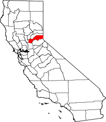
| County | Placer County |
| Elevation[1] | 6,230 ft (1,899 m) |
Tahoe Pines is an unincorporated community in Placer County, California.[1] Tahoe Pines is located on Lake Tahoe, 1 mile (1.6 km) north of Homewood.[2] It lies at an elevation of 6230 feet (1899 m).[1]
The settlement was established in 1909.[2] The Tahoe Pines post office operated from 1912 to 1959.[2]
References
This article is issued from Wikipedia - version of the 7/20/2015. The text is available under the Creative Commons Attribution/Share Alike but additional terms may apply for the media files.