California State Route 28
| ||||
|---|---|---|---|---|
 | ||||
| Route information | ||||
| Defined by Streets and Highways Code § 328 | ||||
| Maintained by Caltrans | ||||
| Length: | 10.943 mi[1] (17.611 km) | |||
| Major junctions | ||||
| West end: |
| |||
|
| ||||
| East end: |
| |||
| Highway system | ||||
| ||||

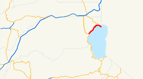
State Route 28 (SR 28) is a state highway in the U.S. state of California that travels along the northern shore of Lake Tahoe, starting at Route 89 in Tahoe City and ending at the Nevada state border, whereupon it becomes Nevada State Route 28.
Route description
This route is part of the California Freeway and Expressway System[2] and is eligible for the State Scenic Highway System.[3] However, it is not an official scenic highway as designated by Caltrans.[4]
The route begins at SR 89 in Tahoe City and heads eastward. It then intersects SR 267 in Kings Beach and continues to its terminus at Nevada State Route 28 at the Nevada state line. Route 28 is one of only three state routes that keep the same number in Nevada, along with Route 88 and Route 266.
Major intersections

Except where prefixed with a letter, postmiles were measured on the road as it was in 1964, based on the alignment that existed at the time, and do not necessarily reflect current mileage. R reflects a realignment in the route since then, M indicates a second realignment, L refers an overlap due to a correction or change, and T indicates postmiles classified as temporary (for a full list of prefixes, see the list of postmile definitions).[1] Segments that remain unconstructed or have been relinquished to local control may be omitted. The entire route is in Placer County.
| Location | Postmile [1][5][6] | Destinations | Notes | ||
|---|---|---|---|---|---|
| Tahoe City | 0.09 | West end of SR 28 | |||
| Kings Beach | 9.34 | ||||
| | 11.03 | Continuation into Nevada; east end of SR 28 | |||
| 1.000 mi = 1.609 km; 1.000 km = 0.621 mi | |||||
External links
| Wikimedia Commons has media related to California State Route 28. |
References
- 1 2 3 California Department of Transportation. "State Truck Route List". Sacramento: California Department of Transportation. Archived from the original (XLS file) on June 30, 2015. Retrieved June 30, 2015.
- ↑ CA Codes (shc:250-257)
- ↑ CA Codes (shc:260-284)
- ↑ "Officially Designated State Scenic Highways and Historic Parkways". California Department of Transportation. December 7, 2007. Retrieved June 22, 2011.
- ↑ California Department of Transportation, Log of Bridges on State Highways, July 2007
- ↑ California Department of Transportation, All Traffic Volumes on CSHS, 2007