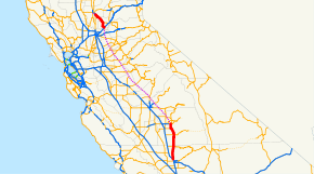
California State Route 65
| ||||
|---|---|---|---|---|
 | ||||
| Route information | ||||
| Defined by Streets and Highways Code § 365 | ||||
| Maintained by Caltrans | ||||
| Length: |
94.217 mi[1] (151.628 km) SR 65 is broken into pieces due to an unconstructed portion, and the length does not reflect the gap. | |||
| Section 1 | ||||
| South end: |
| |||
| Major junctions: |
| |||
| North end: |
| |||
| Section 2 | ||||
| South end: |
| |||
| North end: |
| |||
| Highway system | ||||
| ||||

State Route 65 (SR 65), also known as Highway 65, is a north-south state highway in the U.S. state of California. It is composed of two segments. The southern segment begins at SR 99, near Bakersfield and terminates at SR 198 near Exeter. It also serves the communities of Oildale, Terra Bella, Porterville, and Lindsay. The northern segment begins at Interstate 80 in Roseville and terminates at SR 70 at Olivehurst. It also serves Lincoln and Wheatland.
The route, originally known as the Eastside Freeway, was envisioned as a major freeway connecting northern and southern California. Similar to the Westside Freeway (Interstate 5) on the opposite side of the valley, it would follow the foothills of the Sierra Nevada, traveling almost the entire length of the San Joaquin Valley. However, most of the route was never constructed. Of the estimated 300 miles (480 km), only 95 miles (153 km) were constructed. If built, it would also serve the communities of Ivanhoe, Reedley, Sanger, Waterford, and Oakdale.
Route description
This route is part of the California Freeway and Expressway System.[2]
South segment
The southern segment of State Route 65 begins at a partial interchange with State Route 99 north of Bakersfield. From here to Porterville is a mostly 40-mile (64 km) rural two-lane highway through hills and grasslands while passing through the communities of Ducor and Terra Bella. This stretch of roadway is often considered very dangerous given the heavy amount of semi-trucks that drive this corridor. SR 65 expands to a four-lane freeway through Porterville, downgrading into a four-lane expressway upon leaving the city. The highway remains an expressway, passing Strathmore and up to Lindsay. The highway is then reduced to a rural two-lane highway through agricultural areas while passing through Exeter. SR 65's southern segment ends at the junction of State Route 198. This section has been designated the "All America City Highway."[3]
North segment
The northern segment of State Route 65 begins at the interchange with Interstate 80 in Roseville as a freeway heading northwest to Blue Oaks Boulevard where the freeway turns north towards Lincoln. It turns northwest briefly onto a new stretch of roadway at Industrial Avenue/Lincoln Boulevard (the state route's former alignment) where it then turns west as the freeway ends at Nelson Lane. The highway is then downgraded to a four-lane expressway, turning north again, downgraded further to a two-lane highway, until it meets up with its original alignment just north of the community of Sheridan. After passing through Wheatland, it assumes its freeway designation a few miles north of the town, ending at State Route 70 in Olivehurst.
In 2000, Caltrans issued a Project Study Report (PSR) that analyzed six alternative alignments for the proposed Wheatland Bypass. After extensive public meetings, Caltrans identified Alternative E as the preferred alternative. Alternative E would start at the northern end of the Lincoln Bypass, and proceed due north, crossing the Bear River on a new bridge to the east of the existing SR 65 alignment. It would bypass Wheatland to the east, and then turn west and pass along the southern edge of Beale Air Force Base before connecting to south end of the freeway segment at South Beale Road. If completed, the Wheatland Bypass would enable continuous freeway travel from I-80 to Marysville (via SR 70). Although Caltrans completed the PSR in 2000 that identified the preferred alignment, the Wheatland Bypass remains unfunded. State and local officials cannot present a timetable for completing the bypass until $300 million is secured to complete the required environmental studies and construction.
North of its present northern terminus at SR 70 in Olivehurst, the legislative designation of SR 65 continues west/northwest to SR 99 in (or south of) Yuba City. Caltrans has planned since 1986 to extend SR 65 as a freeway west or northwest from SR 70 to SR 99 via a third bridge across the Feather River south of Yuba City to alleviate traffic on the two existing bridges between Yuba City and Marysville. Funding issues and environmental concerns have stalled the extension of SR 65 to Yuba City and the third Feather River Bridge.
History
Bakersfield to Roseville
The initial segment was created in 1933 as Legislative Route 129. It was defined from LRN 4 (formerly US 99 and currently SR 99) near Bakersfield to LRN 263 (currently SR 180) in Kings Canyon National Park. The entire route was signed Route 65.[4]
In the 1950s, California was developing plans for a statewide freeway network. Within the San Joaquin Valley, routes were discussed on the west side and along U.S. Route 99 (Golden State Highway). However, officials in Stanislaus County believed that an additional major north-south freeway was needed to serve the east side of the valley. In 1955, they formally proposed the Eastside Freeway, which would be the eastern companion to the Westside Freeway. In 1959, the state defined Legislative Route 249, which would run from the junction of LRN 10 (currently SR 198) and LRN 129 to LRN 17 (currently I-80).[5] This would mark the birth of the Eastside Freeway.
In 1964, California's state highways were renumbered. The portion of LRN 129 between Exeter and SR 180 would be removed and become SR 245. The remainder of LRN 129, all of LRN 249, and U.S. Route 99E (section north of Roseville), would be combined to create SR 65.[4] By 1969, except for Merced County, all eight counties which the route would traverse had it included in their general plans.[5] This created a continuous roadway plan from Bakersfield to Roseville.
The first segment to be constructed as a freeway was in 1964. A short freeway segment (about 0.5 miles (0.80 km)) was built at SR 99 in Kern County in conjunction with a portion of the freeway upgrade to the Golden State Freeway (SR 99). However, development of the rest of the corridor was difficult. The California Highway Commission put a greater emphasis on the construction of the Westside Freeway, which would be included in the Interstate Highway System. In addition, efforts were underway for the upgrade of the Golden State Freeway through the center of the valley. As a result, the Eastside Freeway was given a much lower priority.[5]
Most of the construction efforts for the freeway were conducted in Tulare County. In 1970, the segment through the City of Porterville was constructed as a freeway. The two-lane highway between the Tulare County line and SR 198 was converted to a two-lane expressway with land reserved for future interchanges (or interchange footprint). In Sacramento County, land was reserved south of Roseville, and a freeway-to-freeway interchange was constructed at US 50 and Sunrise Boulevard.[4]
By the mid 1970s, California began to abandon some of its freeway projects, which included the Eastside Freeway. The land reserved in Sacramento County was sold and the freeway-to-freeway interchange was converted to a local interchange.[4] The project was considered dead. None of the original LRN 249 segment (between Roseville and Exeter) was constructed.
Roseville to Yuba City
The northern section originally was US 99E, running from Marysville to Roseville, and was converted to SR 65 during the state highway renumbering effort in 1964. A freeway section (named the Harold T. "Bizz" Johnson Expressway) bypassing downtown Roseville was completed later, with the original downtown Roseville section of SR 65 (former US 99E) released from the state highway system. In the 1950s, a right-of-way was reserved for a SR 65 freeway running from Roseville through Citrus Heights and Fair Oaks to Rancho Cordova, but plans for this freeway were abandoned in the 1970s and the right-of-way has been relinquished to private owners. The portion of Sunrise Boulevard south of US 50 was added to the SR 65 routing during the 1970s, but has since been relinquished back to Sacramento County.
In 2008, construction began on a bypass around Lincoln to alleviate traffic congestion in and around the city. The first phase of the bypass is a four-lane freeway from Industrial Avenue/Lincoln Boulevard to Nelson Lane and a two-lane expressway from Nelson Lane to Riosa Road in Sheridan, reconnecting with the original alignment of SR 65 north of town. There is a partial interchange at Industrial Avenue/Lincoln Boulevard, a full interchange at Ferrari Ranch Road and at-grade intersections at Nelson Lane, West Wise Road and Riosa Road. The bypass was completed on October 5, 2012 with a ribbon-cutting ceremony, opening to traffic two days later.[6] A second phase of the Lincoln bypass was completed in June 2014; it expanded to four lanes between Nelson Lane and West Wise Road, with two lanes in each direction.
The interchange at Sunset Boulevard was opened to traffic in March 2010, eliminating the last traffic signal between I-80 and the city of Lincoln. It effectively also upgraded SR 65 from expressway to freeway status from the Sunset Boulevard interchange to just north of the Twelve Bridges Drive interchange.[7]
Future
With the projected growth of the Central Valley, interest has reemerged in constructing all or part of the unconstructed portion of SR 65. A multi-county committee has been formed to discuss the transportation needs of the Eastern Central Valley, including the construction of SR 65 over twenty years. The committee will look at what route the road will take, what type of road would be built (highway, expressway, or freeway), and what the road would eventually become (also known as the ultimate transportation corridor or UTC).[4][8]
In order to alleviate traffic congestion between the northern parts of SR 65 and I-80 and downtown Sacramento, the Placer Parkway project, a bypass from SR 65 to SR 99 to the west, has been initiated and is expected to be finished by 2020.
In addition, another study is looking at extending SR 65 north to a future extension of SR 152. Currently, five cities exist in the eastern Central Valley with population between 15,000 and 20,000 as of the 2000 census. These communities currently do not have a north/south state highway. This project would create a state highway that would connect these cities together and to SR 99. This connection would be north of Madera, providing a bypass to Visalia, and Fresno. It would also provide an alternative route for travelers in Southern California/South Central Valley, to access mountain vacation spots in areas east of Fresno.[4][8]
In the southern section, plans are underway to convert all of the 2-lane highway portions to a 4-lane expressway. In addition, the short segment to Exeter would be moved to allow for a continuous roadway. Originally, the widening project was going to be a joint effort between Kern and Tulare counties, but priority changes in Kern County will delay its portion to a future date.[4]
In the northern section, a third phase of the Lincoln bypass at a future date will expand the highway to four lanes between West Wise Road and Riosa Road and upgrading the at-grade intersections to interchanges. The project is currently unfunded. In the future, SR 65 eventually will become a continuous four-lane freeway from I-80 in Roseville to Riosa Road in Sheridan.[9]
Major intersections
Except where prefixed with a letter, postmiles were measured on the road as it was in 1964, based on the alignment that existed at the time, and do not necessarily reflect current mileage. R reflects a realignment in the route since then, M indicates a second realignment, L refers an overlap due to a correction or change, and T indicates postmiles classified as temporary (for a full list of prefixes, see the list of postmile definitions).[1] Segments that remain unconstructed or have been relinquished to local control may be omitted. The numbers reset at county lines; the start and end postmiles in each county are given in the county column.
| County | Location | Postmile [1][10][11] | Exit [12] | Destinations | Notes | ||
|---|---|---|---|---|---|---|---|
| Kern KER R0.00-25.17 | | R0.00 | Southbound exit and northbound entrance; south end of SR 65; former US 99 / US 466; SR 99 north exit 30 | ||||
| | | North end of freeway | |||||
| | | Serves Meadows Field Airport | |||||
| | 23.19 | ||||||
| Tulare TUL 0.00-39.58 | | R6.98 | |||||
| | R11.86 | ||||||
| Porterville | | South end of freeway | |||||
| 18.16 | 43 | ||||||
| 19.14 | 44 | Olive Avenue (CR J26) – Porterville | |||||
| R20.14 | 45 | Henderson Avenue | |||||
| | North end of freeway | ||||||
| | Pioneer Avenue | No access across SR 65 | |||||
| | | ||||||
| Lindsay | 29.49 | ||||||
| | 31.55 | South end of CR J27 overlap | |||||
| Exeter | 37.65 | ||||||
| | 39.58 | North end of CR J27 overlap | |||||
| Gap in route | |||||||
| Placer PLA R4.86-R24.26 | Roseville | R4.86 | 306 | Southbound exit and northbound entrance; signed as exits 306A (east) and 306B (west); I-80 exit 106 | |||
| R5.93 | 307 | Galleria Boulevard, Stanford Ranch Road | |||||
| R7.10 | 308 | Pleasant Grove Boulevard | |||||
| M8.07 | 309 | Blue Oaks Boulevard, Washington Boulevard | Washington Boulevard was former SR 65 south | ||||
| Rocklin | R9.57 | 311 | Sunset Boulevard – Rocklin | ||||
| | 312 | Whitney Ranch Parkway | No southbound exit; opened September 2016 | ||||
| Lincoln | R11.92 | 313 | Twelve Bridges Drive | ||||
| R12.86 | 314 | Lincoln Boulevard | Northbound exit and southbound entrance; south end of Lincoln bypass; former US 99E / SR 65 north | ||||
| R13.38 | 315 | Ferrari Ranch Road | |||||
| | | North end of freeway | |||||
| | R15.50 | Nelson Lane | At-grade intersection; proposed interchange | ||||
| | | West Wise Road | At-grade intersection; proposed interchange | ||||
| | | Riosa Road – Sheridan | North end of Lincoln bypass; connects to former US 99E / SR 65 south | ||||
| Yuba YUB R0.00-R9.18 | | | South end of freeway | ||||
| | R6.88 | 332 | Forty Mile Road, Ostrom Road | Serves Toyota Amphitheatre | |||
| Olivehurst | R8.03 | 333 | McGowan Parkway | ||||
| R9.18 | Northbound exit and southbound entrance; north end of SR 65; SR 70 south exit 17 | ||||||
1.000 mi = 1.609 km; 1.000 km = 0.621 mi
| |||||||
Other names
Route 65 has the following names, as designated by various state laws:[13]
- All America City Highway: From Route 99 to Route 198. Named for linking "All American Cities" Lindsay, Porterville, and Bakersfield together (it is commonly called Porterville Highway).
- Harold T. "Bizz" Johnson Expressway: The Roseville bypass from Interstate 80 to Blue Oaks Boulevard.
- Officer Mark A. White Memorial Highway: From Sunset Boulevard near Rocklin to Route 193 in Lincoln (via Lincoln Boulevard), honoring the Roseville Police Officer who was killed during a hostage situation.
- Detective Kent Haws Memorial Highway: The entire section that runs through the city of Exeter, honoring the Tulare County Sheriff's detective who was killed in the line of duty.
References
- 1 2 3 California Department of Transportation. "State Truck Route List". Sacramento: California Department of Transportation. Archived from the original (XLS file) on June 30, 2015. Retrieved June 30, 2015.
- ↑ CA Codes (shc:250-257)
- ↑ "2008 Named Freeways, Highways, Structures and Other Appurtenances in California" (PDF). State of California Business, Transportation and Housing Agency, Department of Transportation. January 2009. Archived from the original (PDF) on October 14, 2012. Retrieved February 11, 2012.
- 1 2 3 4 5 6 7 "California Highways 65-72". California Highways.org. Retrieved 2009-09-09.
- 1 2 3 "Counties Link Freeway Plans". The Modesto Bee. June 22, 1969. p. A-4. Retrieved 7 May 2012.
- ↑ Highway 65 Lincoln Bypass
- ↑ "Sunset Boulevard/State Route 65 Interchange Project". Retrieved 2010-04-11.
- 1 2 "High Priority Corridors - Corridor 30". AARoads. Retrieved 2009-09-09.
- ↑ Lincoln Bypass 2A on State Route 65 in Placer County
- ↑ California Department of Transportation, Log of Bridges on State Highways, July 2007
- ↑ California Department of Transportation, All Traffic Volumes on CSHS, 2005 and 2006
- ↑ California Department of Transportation, California Numbered Exit Uniform System, State Route 65 Freeway Interchanges, Retrieved on 2009-02-06.
- ↑ 2007 Named Freeways, Highways, Structures and Other Appurtenances in California (PDF). Caltrans. p. 132. Retrieved 2007-03-28.