Churchill County, Nevada
| Churchill County, Nevada | ||
|---|---|---|
| County | ||
| Churchill County | ||
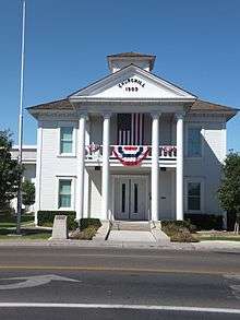 Churchill County Courthouse in Fallon | ||
| ||
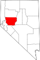 Location in the U.S. state of Nevada | ||
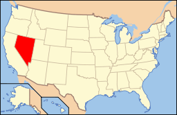 Nevada's location in the U.S. | ||
| Founded | 1861 | |
| Named for | Sylvester Churchill | |
| Seat | Fallon | |
| Largest city | Fallon | |
| Area | ||
| • Total | 5,024 sq mi (13,012 km2) | |
| • Land | 4,930 sq mi (12,769 km2) | |
| • Water | 94 sq mi (243 km2), 1.9% | |
| Population | ||
| • (2010) | 24,877 | |
| • Density | 5.0/sq mi (2/km²) | |
| Congressional district | 2nd | |
| Time zone | Pacific: UTC-8/-7 | |
| Website |
churchillcounty | |

Churchill County is a county located in the western U.S. state of Nevada. As of the 2010 census, the population was 24,877.[1] Its county seat is Fallon. The county, named after Mexican-American War hero brevet Brigadier General Sylvester Churchill, was formed in 1861.
Churchill County comprises the Fallon, NV Micropolitan Statistical Area. It is located in northwestern Nevada.
Churchill County is noteworthy in that it owns and operates the local telephone carrier, Churchill County Communications.
History
Churchill County was established in 1861 and named after Fort Churchill (which is now in Lyon County), which was named after General Sylvester Churchill, a Mexican-American War hero who was Inspector General of the U.S. Army in 1861. Churchill County was not organized until 1864, and its county seats were Bucklands (1861–64)which is now in Lyon County, La Plata (1864–68), Stillwater (1868–1904) and Fallon (1904–present). In the 19th century there were several attempts to eliminate Churchill County because of its small population, but Assemblyman Lemuel Allen was able to stop it on all occasions including convincing the Governor to veto the bill after it had been passed by both houses in 1875.
Railroads
The Eagle Salt Works Railroad ran for 13.5 miles (21.7 km), primarily on the original Central Pacific grade from Luva (2 miles (3.2 km) east of Fernley) to Eagle Salt Works.
The Central Pacific (the first transcontinental railroad) also ran through the county, although a portion of the original route has been shifted for a new route south of Wadsworth in favor of Fernley. The Central Pacific later became the Southern Pacific Railroad which was merged into Union Pacific in 1996.
Geography
According to the U.S. Census Bureau, the county has a total area of 5,024 square miles (13,010 km2), of which 4,930 square miles (12,800 km2) is land and 94 square miles (240 km2) (1.9%) is water.[2] The highest point is Desatoya Peak at 9,977 ft (3,041 m), while the most topograhically prominent peak is Mount Augusta.
Major highways
-
.svg.png) Interstate 11 (Future)
Interstate 11 (Future) -
.svg.png) Interstate 80
Interstate 80 -
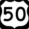 U.S. Route 50
 -
 U.S. Route 50 Alternate
 -
 U.S. Route 95
 - U.S. Route 95 Alternate
-
 State Route 115
 -
 State Route 116
 -
 State Route 117
 -
 State Route 118
 -
 State Route 119
 -
 State Route 120
 -
 State Route 121
 -
 State Route 361
 -
 State Route 715
 -
 State Route 718
 -
 State Route 720
 -
 State Route 722
 -
 State Route 723
 -
 State Route 726
 -
 State Route 839
Adjacent counties
- Lyon County - west
- Washoe County - northwest
- Pershing County - north
- Lander County - east
- Nye County - southeast
- Mineral County - south
National protected areas
Demographics
| Historical population | |||
|---|---|---|---|
| Census | Pop. | %± | |
| 1870 | 196 | — | |
| 1880 | 479 | 144.4% | |
| 1890 | 703 | 46.8% | |
| 1900 | 830 | 18.1% | |
| 1910 | 2,811 | 238.7% | |
| 1920 | 4,649 | 65.4% | |
| 1930 | 5,075 | 9.2% | |
| 1940 | 5,317 | 4.8% | |
| 1950 | 6,161 | 15.9% | |
| 1960 | 8,452 | 37.2% | |
| 1970 | 10,513 | 24.4% | |
| 1980 | 13,917 | 32.4% | |
| 1990 | 17,938 | 28.9% | |
| 2000 | 23,982 | 33.7% | |
| 2010 | 24,877 | 3.7% | |
| Est. 2015 | 24,200 | [3] | −2.7% |
| U.S. Decennial Census[4] 1790-1960[5] 1900-1990[6] 1990-2000[7] 2010-2013[1] | |||
2000 census
As of the census[8] of 2000, there were 23,982 people, 8,912 households, and 6,461 families residing in the county. The population density was 5 people per square mile (2/km²). There were 9,732 housing units at an average density of 2 per square mile (1/km²). The racial makeup of the county was 84.20% White, 1.60% Black or African American, 4.78% Native American, 2.71% Asian, 0.23% Pacific Islander, 3.22% from other races, and 3.27% from two or more races. 8.66% of the population were Hispanic or Latino of any race.
There were 8,912 households out of which 37.20% had children under the age of 18 living with them, 57.70% were married couples living together, 10.40% had a female householder with no husband present, and 27.50% were non-families. 22.50% of all households were made up of individuals and 8.50% had someone living alone who was 65 years of age or older. The average household size was 2.64 and the average family size was 3.09.
In the county the population was spread out with 28.90% under the age of 18, 8.10% from 18 to 24, 28.70% from 25 to 44, 22.30% from 45 to 64, and 11.90% who were 65 years of age or older. The median age was 35 years. For every 100 females there were 100.60 males. For every 100 females age 18 and over, there were 99.10 males.
The median income for a household in the county was $40,808, and the median income for a family was $46,624. Males had a median income of $36,478 versus $25,000 for females. The per capita income for the county was $19,264. About 6.20% of families and 8.70% of the population were below the poverty line, including 10.80% of those under age 18 and 7.00% of those age 65 or over.
2010 census
As of the 2010 United States Census, there were 24,877 people, 9,671 households, and 6,631 families residing in the county.[9] The population density was 5.0 inhabitants per square mile (1.9/km2). There were 10,826 housing units at an average density of 2.2 per square mile (0.85/km2).[10] The racial makeup of the county was 82.0% white, 4.5% American Indian, 2.7% Asian, 1.6% black or African American, 0.2% Pacific islander, 4.8% from other races, and 4.2% from two or more races. Those of Hispanic or Latino origin made up 12.1% of the population.[9] In terms of ancestry, 19.2% were English, 18.8% were German, 13.6% were Irish, 6.5% were Italian, and 5.9% were American.[11]
Of the 9,671 households, 33.2% had children under the age of 18 living with them, 52.0% were married couples living together, 11.3% had a female householder with no husband present, 31.4% were non-families, and 25.2% of all households were made up of individuals. The average household size was 2.53 and the average family size was 3.01. The median age was 39.0 years.[9]
The median income for a household in the county was $51,597 and the median income for a family was $63,599. Males had a median income of $45,057 versus $32,550 for females. The per capita income for the county was $22,997. About 6.8% of families and 8.8% of the population were below the poverty line, including 7.3% of those under age 18 and 10.4% of those age 65 or over.[12]
Communities
- Bernice
- Bolivia
- Boyer
- Clan Alpine
- Clemens
- Cold Springs
- Coppereid
- Dixie
- Dixie Valley
- Eagleville
- Eastgate
- Fallon
- Fallon Station
- Fillmore
- Frenchman
- Gregory
- Hazen
- Humboldt Salt Marsh
- Island City
- Jessup
- Kingston
- Lahontan
- Leete
- Leeteville
- Middlegate
- Miriam
- Nevada City
- Nevada Hills
- Northam
- Parran
- Ragtown
- Red top
- Salt Wells
- Sand Springs
- St. Clair
- Stillwater
- Trinity
- White Cloud City
- Willowtown
See also
- National Register of Historic Places listings in Churchill County, Nevada
- USS Churchill County (LST-583)
References
- 1 2 "State & County QuickFacts". United States Census Bureau. Retrieved September 23, 2013.
- ↑ "2010 Census Gazetteer Files". United States Census Bureau. August 22, 2012. Retrieved December 20, 2014.
- ↑ "County Totals Dataset: Population, Population Change and Estimated Components of Population Change: April 1, 2010 to July 1, 2015". Retrieved July 2, 2016.
- ↑ "U.S. Decennial Census". United States Census Bureau. Archived from the original on May 11, 2015. Retrieved December 20, 2014.
- ↑ "Historical Census Browser". University of Virginia Library. Retrieved December 20, 2014.
- ↑ "Population of Counties by Decennial Census: 1900 to 1990". United States Census Bureau. Retrieved December 20, 2014.
- ↑ "Census 2000 PHC-T-4. Ranking Tables for Counties: 1990 and 2000" (PDF). United States Census Bureau. Retrieved December 20, 2014.
- ↑ "American FactFinder". United States Census Bureau. Archived from the original on 2013-09-11. Retrieved 2008-01-31.
- 1 2 3 "DP-1 Profile of General Population and Housing Characteristics: 2010 Demographic Profile Data". United States Census Bureau. Retrieved 2016-01-21.
- ↑ "Population, Housing Units, Area, and Density: 2010 - County". United States Census Bureau. Retrieved 2016-01-21.
- ↑ "DP02 SELECTED SOCIAL CHARACTERISTICS IN THE UNITED STATES – 2006-2010 American Community Survey 5-Year Estimates". United States Census Bureau. Retrieved 2016-01-21.
- ↑ "DP03 SELECTED ECONOMIC CHARACTERISTICS – 2006-2010 American Community Survey 5-Year Estimates". United States Census Bureau. Retrieved 2016-01-21.
External links
 |
Washoe County | Pershing County | | |
| Lyon County | |
Lander County | ||
| ||||
| | ||||
| Mineral County | Nye County |
Municipalities and communities of Churchill County, Nevada, United States | ||
|---|---|---|
| City | | |
| CDP | ||
| Unincorporated communities | ||
| Indian reservations | ||
| Ghost towns |
| |
Coordinates: 39°36′N 118°20′W / 39.60°N 118.34°W