Amargosa Valley, Nevada
| Amargosa Valley, Nevada | |
|---|---|
| Unincorporated community | |
|
location of Amargosa Valley | |
| Nickname(s): Valley of Faith | |
| Motto: The Jewel of Nye County | |
 Amargosa Valley, Nevada Location in the United States | |
| Coordinates: 36°38′38″N 116°24′01″W / 36.64389°N 116.40028°WCoordinates: 36°38′38″N 116°24′01″W / 36.64389°N 116.40028°W | |
| Country | United States |
| State | Nevada |
| County | Nye |
| Elevation | 2,664 ft (812 m) |
| Population (2010) | |
| • Total | 1,456 |
| Time zone | PST (UTC-8) |
| • Summer (DST) | PDT (UTC-7) |
| ZIP codes | 89020 |
| Area code(s) | 775 |
| Coordinates and elevation from United States Geological Survey[1] | |
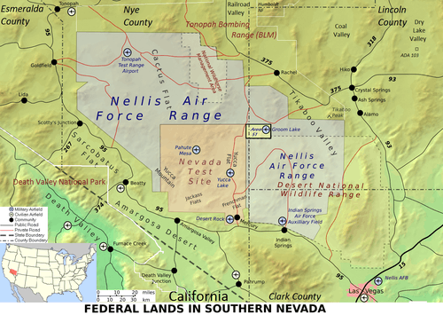
Amargosa Valley (formerly Lathrop Wells) is an unincorporated community in Nye County, in the U.S. state of Nevada.[1]
Description
The community is named for the Amargosa River which flows through the valley from its origination in Nevada to its terminus in Death Valley, California. Like most desert rivers, the 200-mile (320 km) long Amargosa flows on the surface only when rare rainfalls flood the desert washes, except for a 20-mile (32 km) segment near Shoshone, California, where the river flows perennially. The name Amargosa Valley is used locally with reference to the actual geographic valley, although for the most part, it is coincident with the Amargosa Desert and is noted as such on many maps.
The populated area of the Amargosa Valley is sandwiched between U.S. 95 to the north, and the California border to the south. Some of the residential streets in the community cross over into California. Much of the Nevada-California border in this area is contiguous with the boundaries of Death Valley National Park. The national park boundary extends into Nevada near Beatty, approximately 30 miles (50 km) northwest of Amargosa Valley. Amargosa Valley is located approximately 88 miles (142 km) northwest of Las Vegas, 35 miles (56 km) northwest of Pahrump, and 24 miles (39 km) north of Death Valley Junction, California.
History
The Tonopah and Tidewater Railroad ran through the valley from 1906 to 1940, for borax mining operations.[2] Modern development did not begin until the early 1950s. Electric power, other than that produced by private generators, was not available until 1963. Until the early 1990s growth in Amargosa Valley was minimal. More recently, intense growth in Las Vegas has led many new residents to settle in Amargosa Valley and nearby Pahrump.
Geography
Amargosa Valley is located at 36.58001 North, 116.44487 West at an elevation of 2,640 feet (805 m) above sea level. The landscape is typical of lower to moderate elevations in the Mojave Desert, with flat expanses of sandy soil punctuated by rocky mounds and hills. Predominant indigenous vegetation is White Bursage and Creosote Bush, with some Joshua Trees and Cacti at higher elevations. Numerous non-native plant species have also been introduced.
Recreation
Alien Cathouse[3] is one of Nevada's legal brothels. It is located near the corner of U.S. 95 and SR 373. Longstreet Hotel, Casino, and RV Resort is a full-service hotel and casino with restaurants and a RV park. The hotel is located on SR 373, near the Nevada–California border. The hotel is popular with visitors to nearby Death Valley National Park.
References
- 1 2 "Amargosa Valley". Geographic Names Information System (GNIS). United States Geological Survey. December 12, 1980. Retrieved November 7, 2009.
- ↑ "The Great Desert Railroad Race" Documentary written and produced by Ted Faye
- ↑ http://www.Aliencathouse.com
External links
- Amargosa Valley Home Page - privately operated commercial site; not maintained by a government entity
- Amargosa Valley Library
- Amargosa Valley — Google map
- Ash Meadows NWR
- Big Dune — satellite image
Municipalities and communities of Nye County, Nevada, United States | ||
|---|---|---|
| CDPs | 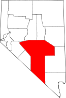 | |
| Other unincorporated communities | ||
| Ghost towns | ||