White Pine County, Nevada
| White Pine County, Nevada | |
|---|---|
| County | |
| White Pine County | |
|
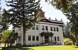
White Pine County Courthouse in Ely | |
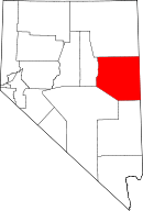 Location in the U.S. state of Nevada | |
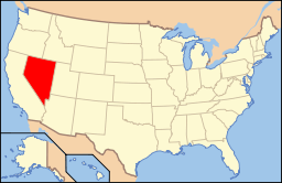 Nevada's location in the U.S. | |
| Founded | 1869 |
| Named for | Limber Pine |
| Seat | Ely |
| Largest city | Ely |
| Area | |
| • Total | 8,897 sq mi (23,043 km2) |
| • Land | 8,876 sq mi (22,989 km2) |
| • Water | 21 sq mi (54 km2), 0.2% |
| Population | |
| • (2010) | 10,030 |
| • Density | 1.1/sq mi (0/km²) |
| Congressional district | 4th |
| Time zone | Pacific: UTC-8/-7 |
| Website |
whitepinecounty |

White Pine County is a county along the central eastern boundary of the U.S. state of Nevada. As of the 2010 census, the population was 10,030.[1] Its county seat is Ely.[2]
The Ely Shoshone Indian Reservation is located on the south side of the city and incorporates part of it. The reservation has a land area of 104.99 acres (0.4249 km²) and a 2000 census official resident population of 133 persons.
The largely rural county is the home of Great Basin National Park. The name "White Pine" is an old name for the Limber Pine, a common tree in the county's mountains.
In 2009, White Pine County ranked ninth in the United States for suicide rates.[3] In 2014, the county ranked fifth for suicide, out of more than 3,100 U.S. counties.[4]
History
White Pine County was established by European Americans in 1869 from Lander County and named after the heavy growth of Limber Pine trees in the area, which were then called white pine. Hamilton was the first county seat from 1869 to 1887, when it was replaced after a fire by Ely.
Geography
According to the U.S. Census Bureau, the county has a total area of 8,897 square miles (23,040 km2), of which 8,876 square miles (22,990 km2) is land and 21 square miles (54 km2) (0.2%) is water.[5]
Several sections of the Humboldt-Toiyabe National Forest exist within the county, within the Snake Range, Egan Range, White Pine Range, Ruby Mountains, and Schell Creek Range. The county also contains Ward Charcoal Ovens State Historic Park and Cave Lake State Park.
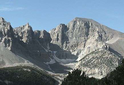
In the southeastern part of the county within Great Basin National Park lies 13,065 ft (3982 m) Wheeler Peak, the tallest independent mountain within Nevada and the second-highest point within the state (the highest point being Boundary Peak).[6] It is also the most topographically prominent peak in the county and the second-most prominent peak in Nevada (after Mount Charleston).
Major highways
Wilderness
White Pine County is home to a number of designated wilderness areas. They were created by Congress on December 20, 2006, by the "White Pine County Conservation, Recreation, and Development Act of 2006."[7] About half are integral parts of Humboldt National Forest. The rest are managed by the Bureau of Land Management. One is shared between the two agencies. Some extend into neighboring counties, as indicated.
- Bald Mountain Wilderness (Humboldt NF)
- Becky Peak Wilderness (BLM)
- Bristlecone Wilderness (BLM)
- Currant Mountain Wilderness (Humboldt NF) partly in Nye County, NV
- Goshute Canyon Wilderness (BLM)
- Government Peak Wilderness (BLM)
- High Schells Wilderness (Humboldt NF)
- Highland Ridge Wilderness (BLM)
- Mount Grafton Wilderness (BLM) partly in Lincoln County, NV
- Mount Moriah Wilderness (Humboldt NF / BLM)
- Red Mountain Wilderness (Humboldt NF) partly in Nye County, NV
- Shellback Wilderness (Humboldt NF)
- South Egan Range Wilderness (BLM) partly in Lincoln County, NV; Nye County, NV
- White Pine Range Wilderness (Humboldt NF)
Adjacent counties
- Elko County - north
- Eureka County - west
- Nye County - southwest
- Lincoln County - south
- Millard County, Utah - east
- Juab County, Utah - east
- Tooele County, Utah - northeast
National protected areas
- Great Basin National Park
- Humboldt-Toiyabe National Forest (part)
- Ruby Lake National Wildlife Refuge (part)
Demographics
| Historical population | |||
|---|---|---|---|
| Census | Pop. | %± | |
| 1870 | 7,189 | — | |
| 1880 | 2,682 | −62.7% | |
| 1890 | 1,721 | −35.8% | |
| 1900 | 1,961 | 13.9% | |
| 1910 | 7,441 | 279.4% | |
| 1920 | 8,935 | 20.1% | |
| 1930 | 11,771 | 31.7% | |
| 1940 | 12,377 | 5.1% | |
| 1950 | 9,424 | −23.9% | |
| 1960 | 9,808 | 4.1% | |
| 1970 | 10,150 | 3.5% | |
| 1980 | 8,167 | −19.5% | |
| 1990 | 9,264 | 13.4% | |
| 2000 | 9,181 | −0.9% | |
| 2010 | 10,030 | 9.2% | |
| Est. 2015 | 9,811 | [8] | −2.2% |
| U.S. Decennial Census[9] 1790-1960[10] 1900-1990[11] 1990-2000[12] 2010-2013[1] | |||
2000 census
As of the census[13] of 2000, there were 9,181 people, 3,282 households, and 2,159 families residing in the county. The population density was 1.0 people per square mile (0.40/km²). There were 4,439 housing units at an average density of 0.50 per square mile (0.19/km²). The racial makeup of the county was 86.35% White, 4.14% Black or African American, 3.29% Native American, 0.78% Asian, 0.24% Pacific Islander, 3.09% from other races, and 2.10% from two or more races. 10.98% of the population were Hispanic or Latino of any race.
There were 3,282 households out of which 31.20% had children under the age of 18 living with them, 51.80% were married couples living together, 9.3% had a female householder with no husband present, and 34.2% were non-families. 29.6% of all households were made up of individuals and 11.5% had someone living alone who was 65 years of age or older. The average household size was 2.42 and the average family size was 3.01.
In the county the population was spread out with 24.2% under the age of 18, 7.6% from 18 to 24, 29.9% from 25 to 44, 24.8% from 45 to 64, and 13.5% who were 65 years of age or older. The median age was 38 years. For every 100 females there were 128.6 males. For every 100 females age 18 and over, there were 138.5 males.
The median income for a household in the county was $36,688, and the median income for a family was $44,136. Males had a median income of $36,083 versus $26,425 for females. The per capita income for the county was $18,309. About 10.3% of families and 11.0% of the population were below the poverty line, including 11.8% of those under age 18 and 7.6% of those age 65 or over.
2010 census
As of the 2010 United States Census, there were 10,030 people, 3,707 households, and 2,344 families residing in the county.[14] The population density was 1.1 inhabitants per square mile (0.42/km2). There were 4,498 housing units at an average density of 0.5 per square mile (0.19/km2).[15] The racial makeup of the county was 85.5% white, 4.2% American Indian, 3.9% black or African American, 1.0% Asian, 0.1% Pacific islander, 2.8% from other races, and 2.5% from two or more races. Those of Hispanic or Latino origin made up 13.2% of the population.[14] In terms of ancestry, 26.9% were American, 11.3% were English, 11.2% were German, 10.4% were Irish, and 5.6% were Italian.[16]
Of the 3,707 households, 28.6% had children under the age of 18 living with them, 48.2% were married couples living together, 8.8% had a female householder with no husband present, 36.8% were non-families, and 30.2% of all households were made up of individuals. The average household size was 2.37 and the average family size was 2.94. The median age was 40.8 years.[14]
The median income for a household in the county was $48,545 and the median income for a family was $62,946. Males had a median income of $51,010 versus $31,453 for females. The per capita income for the county was $21,615. About 11.7% of families and 15.5% of the population were below the poverty line, including 22.6% of those under age 18 and 8.6% of those age 65 or over.[17]
Economy
From the late 19th century until near the end of the 20th century, the major industry was mining the region's deposits of copper, silver, and gold. The most notable of these operations included a series of open-pit copper mines near the town of Ruth, and a copper smelter in McGill, run by the Kennecott Utah Copper Corporation. The decline of mining has meant the loss of area jobs.
Communities
- Baker
- Cherry Creek
- Crosstimbers
- East Ely
- Ely (county seat)
- Lages Station
- Lund
- Majors Place
- McGill
- Riepetown
- Ruth
- Schellbourne
- Strawberry
See also
References
- 1 2 "State & County QuickFacts". United States Census Bureau. Retrieved September 23, 2013.
- ↑ "County Explorer". National Association of Counties. Retrieved 2011-06-07.
- ↑ McCoy, Cara (November 9, 2009). "Analysis of suicide numbers puts Nevada high on list". Las Vegas Sun. Retrieved November 15, 2015.
- ↑ "Suicide a big concern in White Pine County". The Ely Times. November 13, 2015. Retrieved November 15, 2015.
- ↑ "2010 Census Gazetteer Files". United States Census Bureau. August 22, 2012. Retrieved December 20, 2014.
- ↑ "Wheeler Peak, Nevada". Peakbagger.com.
- ↑ Fast facts about America's wilderness - Wilderness.net
- ↑ "County Totals Dataset: Population, Population Change and Estimated Components of Population Change: April 1, 2010 to July 1, 2015". Retrieved July 2, 2016.
- ↑ "U.S. Decennial Census". United States Census Bureau. Retrieved December 20, 2014.
- ↑ "Historical Census Browser". University of Virginia Library. Retrieved December 20, 2014.
- ↑ "Population of Counties by Decennial Census: 1900 to 1990". United States Census Bureau. Retrieved December 20, 2014.
- ↑ "Census 2000 PHC-T-4. Ranking Tables for Counties: 1990 and 2000" (PDF). United States Census Bureau. Retrieved December 20, 2014.
- ↑ "American FactFinder". United States Census Bureau. Retrieved 2008-01-31.
- 1 2 3 "DP-1 Profile of General Population and Housing Characteristics: 2010 Demographic Profile Data". United States Census Bureau. Retrieved 2016-01-21.
- ↑ "Population, Housing Units, Area, and Density: 2010 - County". United States Census Bureau. Retrieved 2016-01-21.
- ↑ "DP02 SELECTED SOCIAL CHARACTERISTICS IN THE UNITED STATES – 2006-2010 American Community Survey 5-Year Estimates". United States Census Bureau. Retrieved 2016-01-21.
- ↑ "DP03 SELECTED ECONOMIC CHARACTERISTICS – 2006-2010 American Community Survey 5-Year Estimates". United States Census Bureau. Retrieved 2016-01-21.
External links
- Official website
-
 Media related to White Pine County, Nevada at Wikimedia Commons
 -
 "White Pine". The American Cyclopædia. 1879.
- "Scientists Voice Their Overwhelming Support for Wilderness Designations in White Pine County, Nevada" by the Wilderness Society
 |
Elko County | Tooele County, Utah | | |
| Eureka County | |
Millard County, Utah and Juab County, Utah | ||
| ||||
| | ||||
| Nye County | Lincoln County |
Municipalities and communities of White Pine County, Nevada, United States | ||
|---|---|---|
| City | | |
| CDPs | ||
| Other unincorporated communities |
| |
| Indian reservation | ||
| Ghost towns | ||
Coordinates: 39°26′N 114°54′W / 39.44°N 114.90°W