List of power stations in California

Los Angeles
San Francisco
San Diego
Shasta
Oroville
Diablo Canyon
Alta
Ivanpah
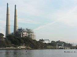
Moss Landing
Ormond Beach
Location of some major power stations in California
 Nuclear,
  Gas,
Gas,  Hydroelectric,
  Coal,
Coal,  Wind / Solar / Biomass
 Cities
This is a map of electricity-generating power stations in California, sorted by type and name.
Coal
| Plant | Location | Coordinates | Capacity (MW) | Refs |
|---|---|---|---|---|
| Argus Cogeneration Plant | Trona, Inyo County, California | 35°45′55.86″N 117°22′30.59″W / 35.7655167°N 117.3751639°W | 55 | [1] |
Nuclear
| Name | Location | Coordinates | Capacity (MW) | Capacity Factor | Annual Generation (GWh) | Ref |
|---|---|---|---|---|---|---|
| Diablo Canyon Power Plant | San Luis Obispo County | 35°12′39.10″N 120°51′22.23″W / 35.2108611°N 120.8561750°W | 2,240 | 90%+ | 18,000 |
Natural Gas-fired
Hydro-electric
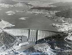
The Shasta Dam
Conventional
*Located along aqueduct or tunnel
Pumped-storage

Castaic Lake and Dam
Wind Power

| Name | Location | Coordinates | Capacity (MW) |
|---|---|---|---|
| Alta Wind Energy Center* | Kern County | 35°00′00″N 118°18′00″W / 35.00000°N 118.30000°W | 1,320 |
| Tehachapi Pass Wind Farm | Tehachapi Mountains | 35°06′08″N 118°16′58″W / 35.10222°N 118.28278°W | 705 |
| San Gorgonio Pass Wind Farm | White Water | 33°54′54″N 116°35′18″W / 33.91500°N 116.58833°W | 615 |
| Altamont Pass Wind Farm | Livermore | 37°43′57″N 121°39′09″W / 37.73250°N 121.65250°W | 576 |
| Ocotillo Wind Energy Facility* | Ocotillo, California[19] | 315[20] | |
| Shiloh Wind Power Plant | Bird's Landing | 38°07′00″N 121°50′30″W / 38.11667°N 121.84167°W | 300 |
| Kumeyaay Wind farm | Campo Indian Reservation[21] | 50[22] |
*Under construction
Solar
Photovoltaic
List of major solar photovoltaic power stations in California as of July 23, 2014.
Thermal
List of current solar thermal power stations in California.
| Station | Location | Coordinates | Capacity (MW) | Status | Notes |
|---|---|---|---|---|---|
| Solar Energy Generating Systems | Mojave Desert | 35°01′54″N 117°20′53″W / 35.03167°N 117.34806°W | 354 | Operational | |
| Kimberlina Solar Thermal Energy Plant | Bakersfield, California | 35°34′06″N 119°12′06″W / 35.56833°N 119.20167°W | 5 | Operational | |
| Sierra SunTower | Lancaster, California | 34°46′0.0″N 118°8′0.0″W / 34.766667°N 118.133333°W | 5 | Operational | |
| Ivanpah Solar Power Facility | Mojave Desert | 35°34′N 115°28′W / 35.57°N 115.47°W | 392 | Operational |
Geothermal
| Plant | Location | Coords. | Capacity (MW) | Refs |
|---|---|---|---|---|
| Calenergy | Calipatria, California | 33°09′49.28″N 115°36′55.78″W / 33.1636889°N 115.6154944°W | 327 | |
| The Geysers | Mayacamas Mountains | 38°47′1″N 122°42′50″W / 38.78361°N 122.71389°W | 750 | [23] |
| Heber | 52 | [23][24] | ||
| Calistoga | 176 | [25] | ||
| Hudson Ranch | 50 | [23] | ||
| Leathers | 36 | [23] | ||
| Mammoth | 40 | [23] | ||
| West Ford Flat | 26 | [23][26] | ||
Biomass
Former facilities
| Plant | Type | Location | Coords. | Capacity (MW) | Year Commissioned | Year Decommissioned | References |
|---|---|---|---|---|---|---|---|
| South Bay Power Plant | Gas-fired | Chula Vista, California | 700 | 2010 | [28] | ||
| Rancho Seco Nuclear Generating Station | Nuclear | Herald, California | 38°20′43″N 121°07′18″W / 38.34528°N 121.12167°W | 917 | 1975 | 2009 | [29] |
| Humboldt Bay Power Plant - Unit 3 | Nuclear | Humboldt Bay, California | 40°44′28.76″N 124°12′32.56″W / 40.7413222°N 124.2090444°W | 65 | 1963 | 1976 | [30] |
| San Onofre Nuclear Generating Station | Nuclear | San Diego County, California | 33°22′8″N 117°33′18″W / 33.36889°N 117.55500°W | 2,150 | 1968 | 2013 | [31] |
| Morro Bay Power Plant | Gas-fired | Morro Bay, California | 35°22′20″N 120°51′24.5″W / 35.37222°N 120.856806°W | 650 | 2014 | [32] |
See also
References
- ↑ "Actual and Expected Energy From Coal for California" (PDF). California Energy Comission. 3 November 2016. Retrieved 3 November 2016.
- 1 2 3 4 5 6 7 8 9 10 11 12 13 14 15 16 17 18 19 20 "Database of California Power Plants". California Energy Commission. 6 November 2012. Retrieved 26 November 2013.
- ↑ "AES Alamitos LLC Gas Plant". Global Energy Observatory. Retrieved 10 May 2014.
- 1 2 3 4 5 6 "CCGT Plants in Southern California". Gallery. Power Plants Around The World. 24 November 2013. Retrieved 10 May 2014.
- 1 2 3 4 "CCGT Plants in Northern California". Gallery. Power Plants Around The World. 3 August 2013. Retrieved 10 May 2014.
- ↑ City of Santa Clara Electric Resources - Silicon Valley Power
- ↑ "NRG Generation Assets" (PDF). NRG Energy. 12 December 2012. Retrieved 26 November 2013.
- ↑ California Energy Commission. "La Paloma Generating Power Plant Project". State of California. Retrieved 27 November 2013.
- 1 2 Two New Calpine Power Plants Begin Commercial Operations in California
- ↑ "Moss Landing Power Plant". Global Energy Observatory. Retrieved 10 May 2014.
- ↑ "Otay Mesa Power Plant Licensing Case". California Energy Commission. State of California. 3 October 2009. Retrieved 15 January 2013.
- ↑ "NRG Generation Assets". NRG Energy. 30 June 2013. Retrieved 26 November 2013.
- ↑ "AES Redondo Beach LLC Gas Plant". Global Energy Observatory. Retrieved 10 May 2014.
- ↑ "SMUD Cosumnes Power Plant Licensing Case - Docket # 01-AFC-19". www.energy.ca.gov. Retrieved 2016-08-01.
- ↑ "Lake Almanor 93-003 Dam". Geographic Names Information System. United States Geological Survey.
- ↑ "Project Facts". Retrieved November 2, 2012.
- ↑ "Indian Valley Dam Hydro Project". Retrieved November 4, 2012.
- ↑ "Aqueduct Power Plant". Los Angeles Department of Water and Power. Retrieved 2014-06-14.
- ↑ Alejandro DaVilla (12 January 2013). "Wind turbine blades spin in Ocotillo". Imperial Valley Press. Retrieved 5 February 2013.
- ↑ "Ocotillo Wind Energy Facility (CACA 051552)". El Centro Field Office. Bureau of Land Management. 15 January 2013. Retrieved 5 February 2013.
- ↑ Onell R. Soto (13 January 2010). "Wind farm: A damaging blow". San Diego Union Tribune. Retrieved 5 February 2013.
- ↑ Michael Connolly. "Kumeyaay Wind Energy Project" (PDF). Tribal Energy Program. U.S. Department of Energy. Retrieved 5 February 2013.
- 1 2 3 4 5 6 "Geothermal Power Plants in the USA". Gallery. Power Plants Around The World. 29 November 2013. Retrieved 10 May 2014.
- ↑ "Heber Geothermal Plant". Global Energy Observatory. Retrieved 10 May 2014.
- ↑ "Calistoga Geothermal Power Plant". Global Energy Observatory. Retrieved 10 May 2014.
- ↑ "West Ford Flat Power Plant Geothermal Plant". Global Energy Observatory. Retrieved 10 May 2014.
- 1 2 3 4 5 6 7 8 9 10 11 12 13 14 15 16 17 18 19 20 21 22 23 24 25 26 27 28 "California Biomass Power Map". UC Berkeley Woody Biomass Utilization Group. Retrieved 21 July 2014.
- ↑ Tony Perry (2 February 2013). "Chula Vista says goodbye to a '50s-era power plant". Los Angeles Times. Retrieved 5 February 2013.
- ↑ "RANCHO SECO-1". Power Reactor Information System. International Atomic Energy Agency. Retrieved 10 May 2014.
- ↑ "HUMBOLDT BAY". Power Reactor Information System. International Atomic Energy Agency. Retrieved 10 May 2014.
- ↑ "Southern California Edison Announces Plans to Retire San Onofre Nuclear Generating Station". SCE Newsroom. June 7, 2013. Retrieved 13 January 2014.
- ↑ Dynegy officially closes the Morro Bay Power Plant, San Luis Obispo Tribune, February 5, 2014
Nuclear Energy in California (CA.gov): http://www.energy.ca.gov/nuclear/california.html retrieved: 11/10/12
External links
- U.S. Department of Energy California Statistics
- U.S. Department of Energy California Quick Facts
- Calenergy Geothermal Plant Information

This article is issued from Wikipedia - version of the 11/3/2016. The text is available under the Creative Commons Attribution/Share Alike but additional terms may apply for the media files.