Trinity Dam
| Trinity Dam | |
|---|---|
 | |
| Country | United States |
| Location | Whiskeytown-Shasta-Trinity National Recreation Area, Trinity County, California |
| Coordinates | 40°48′04″N 122°45′48″W / 40.80111°N 122.76333°WCoordinates: 40°48′04″N 122°45′48″W / 40.80111°N 122.76333°W |
| Construction began | 1957 |
| Opening date | 1962 |
| Owner(s) | U.S. Bureau of Reclamation |
| Dam and spillways | |
| Type of dam | Earthfill |
| Impounds | Trinity River |
| Height | 538 ft (164 m) |
| Length | 2,450 ft (750 m) |
| Spillway type | Morning glory |
| Spillway capacity | 22,400 cu ft/s (630 m3/s) |
| Reservoir | |
| Creates | Trinity Lake |
| Total capacity | 2,447,650 acre·ft (3,019,130 dam3) |
| Inactive capacity | 400,000 acre·ft (490,000 dam3)[1] |
| Catchment area | 692 sq mi (1,790 km2) |
| Surface area | 17,722 acres (7,172 ha) |
| Power station | |
| Hydraulic head | 426 ft (130 m) |
| Turbines | 2x Francis |
| Installed capacity | 140 MW |
| Annual generation | 359 million kWh |
Trinity Dam is an earthfill dam on the Trinity River located about 7 miles (11 km) northeast of Weaverville, California in the United States. The dam was completed in the early 1960s as part of the federal Central Valley Project to provide irrigation water to the arid San Joaquin Valley.
Standing 538 ft (164 m) high, Trinity Dam forms Trinity Lake – California's third largest reservoir, with a capacity of more than 2,400,000 acre feet (3,000,000 dam3). A hydroelectric plant at the base of the dam furnishes power to surrounding rural areas, and the reservoir also provides flood control benefits to the Trinity River valley. However, controversy has surrounded the negative impacts of the dam project on the river's salmon run.
Background
In response to the Great Depression and drought conditions in California during the early 20th century, the United States Congress passed the 1935 Rivers and Harbors Act, which authorized the Central Valley Project (CVP) – a system of dams and canals to provide a stable supply of irrigation water to California's Central Valley.[2] Among the project works was a 1942 proposal to divert water from the Trinity River in northwestern California to augment water supplies in the CVP service area, known as the Trinity River Division. However, the state dropped the Trinity River project from the CVP in 1945.[3]
Six years later, however, the U.S. Bureau of Reclamation (USBR), which was responsible for the construction and operations of most CVP facilities, revived the division, which comprised a system of four dams and two tunnels to capture and store the flow of the Trinity and transport it to the Sacramento River, generating a net surplus of hydroelectric power along the way. Trinity Dam was to be the main storage feature of the division, providing a stable flow to the Lewiston Dam, the diversion point for Trinity River waters into the Central Valley.[3][4]
Construction
Construction at Trinity Dam began on June 4, 1956 with preliminary excavation and the river was diverted around the dam site on July 8, 1957. Work was bogged down in late 1957 when the river flooded and took out the cofferdam that protected the construction site. However, workers cleared out the dam site by the summer of 1958, and the hiatus also allowed them time to line the diversion tunnel with concrete.[3]
Rock placement began on the main structure as early as 1957, but it was not until 1959 when a 11,000 ft (3,400 m) conveyor belt was incorporated, allowing much faster transport of fill to the dam site. The spillway tunnel was completed in October 1959 and the embankment was topped out in late 1960. The dam's power plant, however, was not finished until December 1963. Trinity stood as the highest earthfill dam in the world until eclipsed by the Oroville Dam, also in California, in 1968.[3] The latter remains the tallest dam in the United States.[5]
As the reservoir filled, it submerged the pioneer towns of Trinity Center, Stringtown and Minersville as well as parts of a historic Northern California stagecoach route.[6] The reservoir was originally named Clair Engle Lake after Clair Engle, a United States senator and major proponent of the CVP. This name was unpopular among local residents, many of whom had watched their homes inundated by the rising waters. By 1995, it had been renamed Trinity Lake.[7]
Specifications
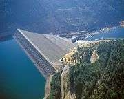
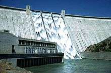
Trinity Dam is an earth and rock-filled dam composed mainly of river gravel and local rock, rising 538 ft (164 m) from its foundations and 440 ft (130 m) above the riverbed. The dam's crest is 2,450 ft (750 m) long and 2,395 ft (730 m) above sea level.[8] High water releases are controlled by three different sets of gates. The outlet works have a capacity of 24,000 cu ft/s (680 m3/s), and the service spillway, a morning-glory (bell-mouth) design, can take 22,400 cu ft/s (630 m3/s) of water. The dam's auxiliary spillway has a capacity of 2,250 cu ft/s (64 m3/s).[9]
Trinity Lake can hold up to 2,447,650 acre feet (3,019,130 dam3) at full pool, and encompasses up to 17,722 acres (7,172 ha) of water.[10] Trinity Powerplant, located at the base of the dam, has two Francis turbines with a capacity of 140 megawatts (MW) combined, uprated from an original capacity of 100 MW. The plant generates an average of 358.97 million kilowatt hours (kWh) and has a low capacity factor, which means it operates mainly on a peaking basis.[11]
Environmental impacts
Trinity Dam forms an impassable barrier for migrating salmon in the Trinity River, but along with other division facilities has also had adverse impacts on salmon habitat in the lower reaches of the river. Within ten years of the dam's completion, more than three-quarters of Trinity River water was being diverted to the Central Valley each year, and the little flow left in the river was warm, shallow and less suitable for spawning salmon. In addition, the dam blocks the Trinity River's annual floods and sediment loads, leading to degradation in the gravel bars that are vital for salmon habitat.[12][13]
In response to declining salmon populations, the USBR built the Trinity River Fish Hatchery. The hatchery is operated by the California Department of Fish and Game and has a capacity of 40 million eggs.[4] In 1992, Congress passed the Central Valley Project Improvement Act, which established a minimum annual release of 340,000 acre feet (420,000 dam3) into the lower Trinity River.[14]
Such as the effects of choking the system of oxygen in a natural habitat.[15] With a lower level of oxygen, it would not be able to meet the demands of the fish that require oxygen in the water to survive.
The building of the Dam has created Trinity Lake and the Trinity River flows through the lake and to the dam, almost all of the 1.2 million acre foot is used elsewhere in California [16] This shows that water that is stored in any reservoir is valuable and is essentially removing it from the natural system. That is a negative aspect to dams in general but specifically this Dam in particular. Also, below the Trinity Dam, is the Lewiston Dam (California) in which that water is sent to other water customers that live throughout the State.[17] This is important because this requires the help of two dams just to move water from the reservoir to the customers that require water for either Agriculture or Urban uses.
Another aspect in which Dams negatively impact the natural ecosystem deals with sediment erosion and sediment deposition. Specifically, the effects dams have on the natural flow of the river such as the natural pulses it has and as well its ability to transfer sediment else where.[18] The fact that the river no longer flows like it used to shows that sediment is backing up. This makes sense because a dam is a large wall blocking the path of the water and sediment. Leaving the natural ecosystem without the benefits of a naturally working cycle of nutrients and water flow.
Just like any national forest, the reservoir of Trinity Lake and . Black Bears and Colombian Blacktail Deer are a few of the most common species of mammals that exist near this dam.[19] These species are iconic for this type of environment and are most likely affected by the creation of the dam. This is also important because it means that even though the environment has been changed since the creation of the dam, most of the mammal species still exist in their natural habitat.
Along with the normal mammal species that inhabit the land, there are of course species that exist in the water since the Trinity Lake exists behind the dam. Related to the environmental aspects of the creation and management of the dam, there had to be some way of lessening our damage on the natural ecosystem of this river system. One of the most commonly used methods are the use of hatcheries to try to sustain a population of fish. Specifically, the Trinity River Hatchery raises and hatches Chinook, Coho Salmon as well as Steelhead Trout for the various runs throughout the year [20] These species are almost iconic in both how they look and what they mean to the natural environment. The combination of the mammal species along with the fish species make up the Trinity Lake region. This is important because like any wild environment there are an abundance of species that have adapted to living in the specific way of life. Species existing in this environment are unique to this area and have adapted to a flooded environment that was not flooded previous to the construction of the dam. The most obvious impact to wildlife is that they now have less area to roam around and forage.This causes concern for species that are using the water for their own needs which conflicts with the needs of the humans that created that environment in the first place.
Drought Effects
The effects of droughts on a dam may seem obvious, such as there is not enough water in the river that feeds the reservoir that the dam holds back. It goes beyond that. The hydrology of any region can be a complicated situation. When a dam releases water for hydropower or any other flood related management, it keeps the water from being able to percolate and recharge the groundwater supplies in the surrounding area of the dam.[21] This is important because it may appear that dams keep a lot of water stored in one place but releasing the water frequently for flood management may cause consequences.
Drought can also affect the amount of hydro power that a dam can create with a lessening amount of water behind the dam, which means less water is pushing turbines [22] This is apparent in dams all across California in which the 5-year drought has taken a toll in electricity production. Drought has that dual effect on supply and electricity generation in which the people of California try to find solutions to this water dilemma. The issue also arises when there is a lessened amount of water for hydro power, electricity demand is switched to alternative sources due to no power production during a drought. This causes the local power companies to rely on other methods for electrical generation because they simply cannot produce enough electricity to meet demand.
Effects on Native People/Towns
The effects of a dam on the Native people are not always published but are well known. Trinity Dam is no different in terms of its effects on the local population that most likely had to adapt in some way to a changing California environment. One negative effect that has the people of the Hoopa Tribe concerned more than anything is the flow of the river and the impact it has on the salmon population.[23] Shortened supplies of food can affect any population whether it is a human population or other animal species. This old photo shows just how long this dam has been built and how much longer it will continue to effect the Native Americans.
.jpg)
Another aspect in which the dam and the drought have negatively affected the local tribes of people that live along the Trinity River. Aside from fish the other species the effects also have flooded places where tribes people use to farm.[23] Tribes are affected by creation of dams since they are the first people to actually live on this side of the world, any negative impact will greatly reduce their livelihoods. Dams appear to have that dual damage of initially flooding then when drought hits they are also reduced in the amount of food they can independently produce.
Hydrology
Hydrology is important for the fully functionality of the Trinity Dam. Nothing is more important than the Trinity River (California) as the life blood for the Reservoir Trinity Lake. The river essentially travels a great distance and is feeding the reservoir with an annual rainfall of 57 inches and is the pathway that the lake receives its water from.[24] This is important because once you understand the hydrology of the region then the construction of the dam will make a lot more sense. As the water enters the system it has to leave eventually and that is where the Lewiston Dam (California) comes into play.
The plan is needed in order to regulate the amount of water that flows through the region so that the Central Valley Project has enough water allocated to its farmers.[25] This can cause the region to have an excess supply of water due to high precipitation in the region which is stored at Trinity Dam and Trinity Lake respectively. This water that is stored at Trinity Lake is used in other regions other than where it is located much like the rest of the dams we have created.
Studying hydrology helps people understand where their water comes from as well as the current status on how full the reservoirs are. With the passing of the drought, the Dam will continue to operate for electricity as well as for storing water for another full year. Trinity river as stated earlier, feeds the dam with a plentiful supply of water. It also creates a reliance on the dam for an ever growing population that is increasing at an unprecedented rate. As shown by this photo of the true power of dams
Recreation/Benefits
With 145 miles (233 km) of shoreline,[26] Trinity Lake is a popular summer destination for Northern California residents. Since 1965, the lake has been part of the Trinity Unit of the Whiskeytown-Shasta-Trinity National Recreation Area. The lake has been developed with boat ramps and marinas, most of which are concentrated in the Stuart Fork arm in the southwest and around the resort town of Trinity Center near the north end of the reservoir.[27]
One of the most important features that dams provide are how it benefits people. Next to actually holding back water, the next important function is flood control. The storms that pass in winter can fill up a dam and in order to keep farmers and urban residents from drowning, the dam has to be able to release water in a controlled way so that people downstream do not drown from such a hazard.[28] Flood control is an integral part in maintaining the functions of the dam. Having the ability to hold back water for flood management is a great benefit to society because the economic losses to a great flood would hurt the local economy of farmers. This means that people downstream can rest easy knowing that the water is not going to periodically flood their land and homes. This is especially important when there is a drought present, losing any amount of water for flood protection appears counter intuitive. Having controlled releases helps save lives by the work of FEMA and other governmental agencies.[28]
See also
- List of dams and reservoirs in California
- List of largest reservoirs of California
- List of power stations in California
- List of the tallest dams in the United States
References
- ↑ Ritzema, Randall S.; Newlin, Brad D.; Van Lienden, Brian J. (October 2001). "Appendix H: Infrastructure" (PDF). CALVIN Project. University of California Davis. Retrieved 2014-01-25.
- ↑ "Central Valley Project". U.S. Bureau of Reclamation. 2011-04-21. Retrieved 2012-02-12.
- 1 2 3 4 Stene, Eric A. (1996). "Trinity Division: Central Valley Project". U.S. Bureau of Reclamation. Retrieved 2012-02-12.
- 1 2 "Shasta/Trinity River Division Project". Central Valley Project. U.S. Bureau of Reclamation. 2011-04-21. Retrieved 2012-02-12.
- ↑ "Oroville Dam and Lake Oroville". California State Water Project. California Department of Water Resources. 2009-06-17. Retrieved 2012-02-12.
- ↑ Jones, Carolyn (2011-09-12). "Anger lingers over towns flooded by Trinity Dam". San Francisco Chronicle. Retrieved 2012-02-12.
- ↑ "Designation of Trinity Lake" (PDF). 104th Congress, 1st Session. U.S. Government Printing Office. 1995-06-07. Retrieved 2012-02-12.
- ↑ "Trinity Dam: Dimensions". Shasta/Trinity River Division Project. U.S. Bureau of Reclamation. 2009-06-04. Retrieved 2012-02-12.
- ↑ "Trinity Dam: Hydraulics & Hydrology". Shasta/Trinity River Division Project. U.S. Bureau of Reclamation. 2009-06-04. Retrieved 2012-02-12.
- ↑ "Trinity Dam". National Performance of Dams Program. Stanford University. Retrieved 2012-02-12.
- ↑ "Trinity Powerplant". Shasta/Trinity River Division Project. U.S. Bureau of Reclamation. 2001-04-04. Retrieved 2012-02-12.
- ↑ "Upper Trinity River Population" (PDF). SONCC Coho Salmon Recovery Plan. National Oceanic and Atmospheric Administration. January 2012. Retrieved 2012-02-12.
- ↑ "Background". Trinity River Restoration Program. Retrieved 2012-02-12.
- ↑ "Trinity River Restoration Program Overview" (PDF). CVPIA Annual Work Plan. U.S. Bureau of Reclamation. 2011-02-17. Retrieved 2012-02-12.
- ↑ Sanguri, Mohit. "Negative Impacts of Hydroelectric Dams". Bright Hub Engineering. Retrieved 14 March 2016.
- ↑ Aaron J. Douglas; Jonathan G. Taylor. "The Economic Value of Trinity River Water" (PDF). Retrieved 31 March 2016.
- ↑ Aaron J. Douglas; Jonathan G. Taylor. "The Economic Value of Trinity River Water" (PDF). Retrieved 31 March 2016.
- ↑ G. Mathias Kondolf. "Hungry Water: Effects of Dams and Gravel Mining on River Channels" (PDF). Retrieved 24 April 2016.
- ↑ USDA and Forest Service. "Mammals of the Shasta-Trinity" (PDF). Retrieved 3 April 2016.
- ↑ Fisheries Branch California Department Fish and Wildife. "Species Raised at Trinity River Hatchery". Retrieved 24 April 2016.
- ↑ Peter Bosshard (8 June 2011). "How Dams Can Bring About Rainfall and Drought". International Rivers. Retrieved 3 April 2016.
- ↑ Mary Ann Capeheart. "Drought Diminishes Hydropower Capacity in Western U.S". Water Resources Research Center. Water Resources Research Center. Retrieved 9 May 2016.
- 1 2 Kevin Taylor (19 March 2014). "Drought hits harder in already parched Indian Country". Aljazeera America. Retrieved 3 April 2016.
- ↑ NorthCoastRR_Reg_Forum (30 September 2013). "North Coast Hydrologic Region Report" (PDF). Water Plan Ca. Retrieved 3 April 2016.
- ↑ NorthCoastRR_Reg_Forum (30 September 2013). "North Coast Hydrologic Region Report" (PDF). Water Plan Ca. Retrieved 3 April 2016.
- ↑ "Trinity Lake – Bureau of Reclamation". Recreation.gov. Retrieved 2012-02-12.
- ↑ "Trinity Unit" (PDF). Whiskeytown-Shasta-Trinity National Recreation Area. U.S. Forest Service. 2003. Retrieved 2012-02-12.
- 1 2 FEMA U.S. Department of Homeland Security (6 January 2016). "Benefits of Dams". Retrieved 24 April 2016.
External links
| Wikimedia Commons has media related to Trinity Dam. |
- Bathymetric map and navigation safety on Trinity Lake
- California Department of Water Resources: Trinity Lake Reservoir Up-to-Date Data
- Trinity River Restoration Program
- USBR Central Valley Operations Office