Oroville Dam
| Oroville Dam | |
|---|---|
 | |
| Country | United States |
| Location | Oroville, California |
| Coordinates | 39°32′20″N 121°29′08″W / 39.53889°N 121.48556°WCoordinates: 39°32′20″N 121°29′08″W / 39.53889°N 121.48556°W |
| Construction began | 1961 |
| Opening date | 1968 |
| Dam and spillways | |
| Type of dam | Rockfill embankment |
| Impounds | Feather River |
| Height | 770 ft (230 m)[1] |
| Length | 6,920 ft (2,110 m)[1] |
| Dam volume | 77,619,000 cu yd (59,344,000 m3) |
| Spillway type | Service, 8x gate-controlled |
| Spillway capacity | 250,000 cu ft/s (7,100 m3/s) |
| Reservoir | |
| Creates | Lake Oroville |
| Total capacity | 3,537,577 acre·ft (4.363537 km3)[2] |
| Inactive capacity | 29,600 acre·ft (0.0365 km3)[3] |
| Catchment area | 3,607 sq mi (9,340 km2)[2] |
| Surface area | 15,805 acres (6,396 ha)[2] |
| Normal elevation | 935 ft (285 m) (max)[4] |
| Power station | |
| Hydraulic head | 615 ft (187 m)[5] |
| Turbines |
3x conventional 3x pump-generators |
| Installed capacity | 819 MW[5] |
| Annual generation | 1,490 GWh[6] |
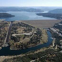
Oroville Dam is an earthfill embankment dam on the Feather River east of the city of Oroville, California in the United States. At 770 feet (230 m) high, it is the tallest dam in the U.S.[7] and serves mainly for water supply, hydroelectricity generation and flood control. The dam impounds Lake Oroville, the second largest man-made lake in the state of California, capable of storing more than 3.5 million acre-feet (4.4 km3),[8] and is located in the Sierra Nevada foothills east of the Sacramento Valley.
Built by the California Department of Water Resources (DWR), Oroville Dam is one of the key features of the California State Water Project (SWP), one of two major projects passed that set up California's statewide water system. Construction was initiated in 1961, and despite numerous difficulties encountered during its construction, including multiple floods and a major train wreck on the rail line used to transport materials to the dam site, the embankment was topped out in 1967 and the entire project was ready for use in 1968. The dam began to generate electricity after completion of the Edward Hyatt Pump-Generating Plant, then the country's largest underground power station.
Since its completion in 1968, the Oroville Dam has allocated the flow of the Feather River from the Sacramento-San Joaquin Delta into the State Water Project's California Aqueduct, which provides a major supply of water for irrigation in the San Joaquin Valley as well as municipal and industrial water supplies to coastal Southern California, and has prevented large amounts of flood damage to the area – more than $1.3 billion between the years of 1987 and 1999.[9] The dam has confined fish migration up the Feather River and the controlled flow of the river as a result of the Oroville Dam has affected riparian habitat. Multiple aims at trying to counter the dam's impacts on anadromous fish have included the construction of a salmon/steelhead incubator on the river which began shortly after the dam was completed.
History
In 1935, work began on the Central Valley Project (CVP), a federal water project that would develop the Sacramento and San Joaquin river systems for irrigation of the highly fertile Central Valley. However, after the end of World War II in 1945, the state experienced an economic boom that led to rapid urban and commercial growth in the central and southern portions of the state, and it became clear that California's economy could not depend solely on a state water system geared primarily towards agriculture. A new study of California's water supplies by the Division of Water Resources (now California Department of Water Resources, DWR) was carried out under an act of the California State Legislature in 1945.[10]
In 1951, California State Engineer A.D. Edmonston proposed the Feather River Project, the direct predecessor to the SWP, which included a major dam on the Feather River at Oroville, and aqueducts and pumping plants to transfer stored water to destinations in central and southern California. The proposed project was strongly opposed by voters in Northern California and parts of Southern California that received water from the Colorado River, but was supported by other Southern Californians and San Joaquin Valley farmers. However, major flooding in the 1950s prompted the 1957 passage of an emergency flood-control bill that provided sufficient funding for construction for a dam at Oroville, whether it would be part of the SWP or not. Groundbreaking on the dam site occurred in May 1957 with the relocation of the Western Pacific Railroad tracks that ran through the Feather River canyon. The Burns-Porter Act, which authorized the SWP, was not passed until November 8, 1960 – and only by a slim margin.[10][11] Engineer Donald Thayer of the DWR was commissioned to design and head construction of Oroville Dam, and the primary work contract was awarded to Oro Dam Constructors Inc., a joint venture led by Oman Construction Co.[12]
Two concrete-lined diversion tunnels, each 4,400 feet (1,300 m) long and 35 feet (11 m) in diameter, were excavated to channel the Feather River around the dam site. One of the tunnels was located at river level and would carry normal water flows, while the second one would only be used during floods.[13] In May 1963, workers poured the last of 252,000 cubic yards (193,000 m3) of concrete that comprised the 128-foot (39 m) high cofferdam, which would protect the construction site from floods. This structure would later serve as an impervious core for the completed dam. With the cofferdam in place, an 11-mile (18 km) rail line was constructed to move earth and rock to the dam site. An average of 120 train cars ran along the line each hour, transporting fill that was mainly excavated from enormous piles of hydraulic mining debris that were washed down by the Feather River after the California Gold Rush.[14]
On December 22, 1964, disaster nearly struck when the Feather River, after days of heavy rain, reached a peak flow of 250,000 cubic feet per second (7,100 m3/s) above the Oroville Dam site. The water rose behind the partially completed embankment dam and nearly overtopped it, while a maximum of 157,000 cubic feet per second (4,400 m3/s) poured from the diversion tunnels. This Christmas flood of 1964 was one of the most disastrous floods on record in Northern California, but the incomplete dam was able to reduce the peak flow of the Feather River by nearly 40 percent, averting massive amounts of damage to the area.[15][16] Ten months later, four men died in a tragic accident on the construction rail line. On October 7, 1965, two 40-car work trains, one fully loaded and the other empty, collided head-on at a tunnel entrance, igniting 10,000 US gallons (38,000 l) of diesel fuel, completely destroying the two locomotives. The burning fuel from the collision started a forest fire that burned 100 acres (40 ha) before it could be extinguished. The crash delayed construction of the Dam by a week while the train wreckage was cleared.[17]
Oroville Dam was designed to withstand the strongest possible earthquake for the region, and was fitted with hundreds of instruments that serve to measure water pressure and settlement of the earth fill used in its construction, earning it the nickname "the dam that talks back".[18] (It is believed that a MW 5.7 earthquake in the Oroville area in 1975 was caused by induced seismicity from the weight of the Oroville Dam and reservoir itself on a local fault line.[19]) The embankment was finally topped out on October 6, 1967, with the last of 155 million tons (140.6 million t) of material that took over 40,000 train trips to transport.[14] On May 4, 1968 Oroville Dam was officially dedicated by the state of California. Among the notable figures present were Chief Justice (formerly California governor) Earl Warren, Senator Thomas Kuchel, and California Representative Harold T. "Bizz" Johnson.[20] The dedication was accompanied by a week of festivities in nearby Oroville, attended by nearly 50,000 people.[21]
Operations
Construction of the underground Edward Hyatt Pump-Generating Plant was finished shortly after the completion of Oroville Dam. At the time, it was the largest underground power station in the United States,[14] with three 132 megawatt (MW) conventional turbines and three 141 MW pump-generators for a total installed capacity of 819 MW.[5] The Hyatt Powerplant is capable of pumping water back into Lake Oroville when surplus power is available. The pump-generators at Hyatt can lift up to 5,610 cubic feet per second (159 m3/s) into Lake Oroville (with a net consumption of 519 MW), while the six turbines combined utilize a flow of 16,950 cubic feet per second (480 m3/s) at maximum generation.[22]
Since 1969, the Hyatt plant has worked in tandem with an extensive pumped-storage operation comprising two offstream reservoirs west of Oroville. These two facilities are collectively known as the Oroville-Thermalito Complex.[23] Water is diverted into the upper Thermalito reservoir (Thermalito Forebay) via the Thermalito Diversion Dam on the Feather River. During periods of off-peak power use, surplus energy generated at Hyatt is used to lift water from Thermalito's lower reservoir (the Thermalito Afterbay) to the forebay, which releases water back into the afterbay to generate up to 114 MW of power at times of high demand.[24] The Hyatt and Thermalito plants produce an average of 2.2 billion kilowatt hours (KWh) of electricity each year, about half of the total power produced by the SWP's eight hydroelectric facilities.[25][26]
Water released from Oroville Dam travels down the Feather River before joining with the Sacramento River, eventually reaching the Sacramento-San Joaquin Delta, where the SWP's California Aqueduct diverts the freshwater for transport to the arid San Joaquin Valley and Southern California. Oroville-Thermalito hydroelectric facilities furnish about one-third of the power necessary to drive the pumps that lift the water in the aqueduct from the delta into the valley, and then from the valley over the Tehachapi Mountains into coastal southern California.[26][27] Water and power from the dam contributes to the irrigation of 755,000 acres (306,000 ha) in the arid San Joaquin Valley Westside and municipal supplies to some 25 million people.[28]
During the winter and early spring, Lake Oroville is required to have at least 750,000 acre feet (0.93 km3), or a fifth of the reservoir's storage capacity, available for flood control.[29] The dam is operated to maintain an objective flood-control release of 150,000 cubic feet per second (4,200 m3/s), which may be further reduced during large storms when flows below the Feather's confluence with the Yuba River exceed 300,000 cubic feet per second (8,500 m3/s).[30] In the particularly devastating flood of 1997 inflows to the reservoir hit more than 331,000 cubic feet per second (9,400 m3/s), but dam operators managed to limit the outflow to 160,000 cubic feet per second (4,500 m3/s), sparing large regions of the Sacramento Valley from flooding.[31][32]
Oroville Dam completely blocks migrations of Chinook salmon and steelhead in the Feather River. In 1967, in an effort to compensate for lost habitat, the DWR and the California Department of Fish and Game completed the Feather River Fish Hatchery. The Fish Barrier Dam, built in 1962, intercepts fish before they reach the base of the impassable Thermalito Diversion Dam and forces them to swim up a fish ladder to the hatchery, which is located on the north bank of the Feather River. The hatchery produces 10 million salmon smolt to stock in the river each year, with 20% for the spring run and 80% for the fall run. This facility has been successful enough that there is concern that salmon of hatchery stock is out-competing remaining wild salmon in the Feather River system.[33][34]
See also
- List of dams and reservoirs in California
- List of lakes in California
- List of largest reservoirs of California
- List of power stations in California
- List of tallest dams in the United States
- New Bidwell Bar Bridge
References
- 1 2 "Oroville Dam". National Performance of Dams Program. Stanford University. Retrieved 2012-03-31.
- 1 2 3 "Oroville Dam (ORO)". California Data Exchange Center. California Department of Water Resources. Retrieved 2012-03-31.
- ↑ Ritzema, Randall S.; Newlin, Brad D.; Van Lienden, Brian J. (October 2001). "Appendix H: Infrastructure" (PDF). CALVIN Project. University of California Davis. Retrieved 2014-01-25.
- ↑ "Lake Oroville". Geographic Names Information System. United States Geological Survey. 1981-01-19. Retrieved 2012-03-31.
- 1 2 3 "Edward Hyatt Powerplant". California State Water Project. California Department of Water Resources. 2009-06-17. Retrieved 2012-04-02.
- ↑ "California Hydroelectric Statistics & Data". California Energy Commission. Retrieved 2015-01-24.
- ↑ "Dam, Hydropower and Reservoir Statistics". United States Society on Dams. Retrieved 2012-03-31.
- ↑ "Alphabetical List of California Dams (Over 40,000 acre feet)". Civil and Environmental Engineering. University of California Davis. Retrieved 2012-03-31.
- ↑ "The Benefits of Dams to Society". USCOLD Newsletter. United States Society on Dams. March 1999. Retrieved 2012-09-04.
- 1 2 "History of Water Development and the State Water Project". California Department of Water Resources. 2008-10-08. Retrieved 2012-04-02.
- ↑ Keats, Adam (October 2007). "2. State Water Project" (PDF). Water Wars: Present and Future. Planning and Conservation League. Retrieved 2012-04-02.
- ↑ "Exhibit C: Construction History and Proposed Construction Schedule" (PDF). Oroville Facilities FERC Project No. 2100. California Department of Water Resources. January 2005. Retrieved 2012-04-04.
- ↑ "History". Oroville – The Forgotten Golden City. Oracle ThinkQuest Education Foundation. Retrieved 2012-04-02.
- 1 2 3 Hoffer, William (July 1985). "Taming the Feather River: The Feather River took one life too many. So they built the Oroville Dam. It's a civil engineering landmark today.". Popular Mechanics. 162 (7): 78–80.
- ↑ "Flood! December 1964 – January 1965". California Department of Water Resources Bulletin No. 161. Internet Archive. Retrieved 2012-04-02.
- ↑ "California Flood Control Program, 1965". California Department of Water Resources Bulletin No. 159-65. Internet Archive. 1965. Retrieved 2012-04-02.
- ↑ Associated Press (1965-10-09). "Bodies of Train Crash Victims Are Recovered". Lodi News-Sentinel.
- ↑ Griswold, Wesley S. (February 1967). "The Dam That Talks Back: World's highest earth dam will keep an eye on itself to report every stress and strain". Popular Science. 190 (2): 86–87.
- ↑ Allen, Clarence R. (November 1982). "Reservoir-Induced Earthquakes and Engineering Policy". California Geology. 35 (11).
- ↑ Associated Press (1968-05-04). "Massive Dam At Oroville Is Dedicated". Merced Sun-Star.
- ↑ Associated Press (1968-05-04). "Oroville Dam Dedication Today". The Press-Courier.
- ↑ "Section 2: Proposed Action and Alternatives". Federal Energy Regulatory Commission Final Environmental Impact Statement for the Oroville Facilities Project. Butte County, California. pp. 13–42. Retrieved 2012-04-02.
- ↑ "Oroville Reservoir and Thermalito Facilities". Northern California Water Association. Retrieved 2012-04-02.
- ↑ Zmuda, Joseph (September 1972). "Slaking California's mammoth thirst with The World's Largest Water: Surplus water from the north now flows to arid regions via this gigantic $2.3 billion project". Popular Science. 201 (3): 62–64.
- ↑ "Chapter 7: Power Production and Energy Consumption" (PDF). Proposed Lower Yuba River Accord. Yuba River Management Team. June 2007. Retrieved 2012-04-02.
- 1 2 "Benefits Of The California State Water Project". California Department of Water Resources. 2008-07-18. Retrieved 2012-04-02.
- ↑ "Power Resources". Bulletin 132–95. California Department of Water Resources. Retrieved 2012-04-02.
- ↑ "California State Water Project Overview". California Department of Water Resources. 2010-08-11. Retrieved 2012-04-02.
- ↑ "Oroville Facilities". California State Water Project. California Department of Water Resources. 2009-06-17. Retrieved 2012-04-02.
- ↑ "Chapter 6: Assessment of Current Flood Management Systems" (PDF). U.S. Army Corps of Engineers, Sacramento District: Post-Flood Assessment for 1983, 1986, 1995 and 1997. Auburn Dam Council. Retrieved 2012-04-02.
- ↑ Roos, Maurice (1997). "The Great New Year's Flood of 1997" (PDF). California Extreme Precipitation Symposium. Retrieved 2012-04-02.
- ↑ "Oroville Dam (ORO) Data Query (REL SCH) for 01/01/1997 through 01/02/1997". California Data Exchange Center. California Department of Water Resources. Retrieved 2015-08-10.
- ↑ "Mariculture: Chinook Salmon and Steelhead Trout". MarineBio.net Marine Science. 2003. Retrieved 2012-04-02.
- ↑ Weston, Mary (2010-10-08). "Salmon spawning under way at Feather River hatchery". ChicoER. Retrieved 2012-04-02.
External links
| Wikimedia Commons has media related to Oroville Dam. |
- The Oroville Dam Train Tunnel Disaster
- Oroville Dam
- Department of Water Resources State Water Project, Oroville overview
- Oroville Facilities Relicensing
- State Water Project