Blue Lake, California
| City of Blue Lake | |
|---|---|
| City | |
 Location in Humboldt County and the state of California | |
| Coordinates: 40°52′58″N 123°59′02″W / 40.88278°N 123.98389°WCoordinates: 40°52′58″N 123°59′02″W / 40.88278°N 123.98389°W | |
| Country |
|
| State |
|
| County | Humboldt |
| Incorporated | April 23, 1910[1] |
| Government | |
| • Type | Mayor-council government |
| • Mayor | Sherman Schapiro[2] |
| • City Manager | John Berchtold[3] |
| Area[4] | |
| • Total | 0.622 sq mi (1.610 km2) |
| • Land | 0.592 sq mi (1.533 km2) |
| • Water | 0.030 sq mi (0.077 km2) 4.8% |
| Elevation[5] | 131 ft (40 m) |
| Population (2010) | |
| • Total | 1,253 |
| • Density | 2,000/sq mi (780/km2) |
| Time zone | Pacific (PST) (UTC-8) |
| • Summer (DST) | PDT (UTC-7) |
| ZIP code | 95525 |
| Area code(s) | 707 |
| FIPS code | 06-07162 |
| GNIS feature IDs | 1658083, 2409868 |
| Website |
bluelake |
Blue Lake (formerly, Scottsville)[6] is a city in Humboldt County, California, United States. Blue Lake is located on the Mad River, 16 miles (26 km) northeast of Eureka,[6] at an elevation of 131 feet (40 m).[5] The population was 1,253 at the 2010 census, up from 1,135 in 2000.
Geography
According to the United States Census Bureau, the city has a total area of 0.6 square miles (1.6 km2), over 95% of which is land.
History
Present Blue Lake comprises "old" Blue Lake, Powersville, and Scottsville. In 1854, Augusta Bates settled in the Scottsville area and sold to Brice M. Stokes in 1862. In 1861, the 13-acre Blue Lake was formed from flooding of the north fork of Mad River, and it gave the town a resort atmosphere. As the river change courses in the 1920s, the lake disappeared to become what today is a small pond on private property.[7]
In 1866, William Scott purchased land from Brice M. Stokes and established "Scott's Farm," later becoming Scottsville. Powersville was established in 1869 by David Powers on land originally claimed by Augusta Bates, Brice M. Stokes and William Scott.[8]
In 1876 a post office opened, named "Mad River." The post office named Blue Lake was established in 1878. The town of Blue Lake was incorporated on April 11, 1910.[7]
Lumber industry
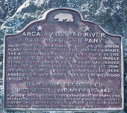
The lumber industry shipped wood down the Arcata and Mad River Railroad. During the 1950s, timber shipped from Blue Lake included from Levitt Brothers own lumberyard and nail factory from which lumber and nails were sent to the four Levittown developments in the eastern U.S.[9]
Demographics
| Historical population | |||
|---|---|---|---|
| Census | Pop. | %± | |
| 1910 | 507 | — | |
| 1920 | 441 | −13.0% | |
| 1930 | 555 | 25.9% | |
| 1940 | 503 | −9.4% | |
| 1950 | 824 | 63.8% | |
| 1960 | 1,234 | 49.8% | |
| 1970 | 1,112 | −9.9% | |
| 1980 | 1,201 | 8.0% | |
| 1990 | 1,235 | 2.8% | |
| 2000 | 1,135 | −8.1% | |
| 2010 | 1,253 | 10.4% | |
| Est. 2015 | 1,252 | [10] | −0.1% |
2010
The 2010 United States Census[12] reported that Blue Lake had a population of 1,253. The population density was 2,015.6 people per square mile (778.2/km²). The racial makeup of Blue Lake was 1,094 (87.3%) White, 5 (0.4%) African American, 55 (4.4%) Native American, 13 (1.0%) Asian, 4 (0.3%) Pacific Islander, 24 (1.9%) from other races, and 58 (4.6%) from two or more races. Hispanic or Latino of any race were 82 persons (6.5%).
The Census reported that 1,253 people (100% of the population) lived in households, 0 (0%) lived in non-institutionalized group quarters, and 0 (0%) were institutionalized.
There were 542 households, out of which 152 (28.0%) had children under the age of 18 living in them, 215 (39.7%) were opposite-sex married couples living together, 63 (11.6%) had a female householder with no husband present, 32 (5.9%) had a male householder with no wife present. There were 45 (8.3%) unmarried opposite-sex partnerships, and 12 (2.2%) same-sex married couples or partnerships. 161 households (29.7%) were made up of individuals and 45 (8.3%) had someone living alone who was 65 years of age or older. The average household size was 2.31. There were 310 families (57.2% of all households); the average family size was 2.79.
The population was spread out with 248 people (19.8%) under the age of 18, 102 people (8.1%) aged 18 to 24, 361 people (28.8%) aged 25 to 44, 415 people (33.1%) aged 45 to 64, and 127 people (10.1%) who were 65 years of age or older. The median age was 38.3 years. For every 100 females there were 95.8 males. For every 100 females age 18 and over, there were 92.9 males.
There were 572 housing units at an average density of 920.1 per square mile (355.3/km²), of which 301 (55.5%) were owner-occupied, and 241 (44.5%) were occupied by renters. The homeowner vacancy rate was 1.0%; the rental vacancy rate was 2.8%. 712 people (56.8% of the population) lived in owner-occupied housing units and 541 people (43.2%) lived in rental housing units.
2000
As of the census[13] of 2000, there were 1,135 people, 504 households, and 297 families residing in the city. The population density was 1,884.2 people per square mile (730.4/km²). There were 556 housing units at an average density of 923.0 per square mile (357.8/km²). The racial makeup of the city was 88.72% White, 0.53% Black or African American, 5.37% Native American, 1.32% Asian, 0.09% Pacific Islander, 1.15% from other races, and 2.82% from two or more races. 2.47% of the population were Hispanic or Latino of any race.
There were 504 households out of which 27.4% had children under the age of 18 living with them, 41.9% were married couples living together, 13.7% had a female householder with no husband present, and 40.9% were non-families. 31.5% of all households were made up of individuals and 9.3% had someone living alone who was 65 years of age or older. The average household size was 2.25 and the average family size was 2.84.
In the city the population was spread out with 21.9% under the age of 18, 8.4% from 18 to 24, 29.6% from 25 to 44, 27.7% from 45 to 64, and 12.4% who were 65 years of age or older. The median age was 39 years. For every 100 females there were 93.0 males. For every 100 females age 18 and over, there were 86.9 males.
The median income for a household in the city was $32,500, and the median income for a family was $37,500. Males had a median income of $35,924 versus $25,563 for females. The per capita income for the city was $17,603. About 6.3% of families and 11.1% of the population were below the poverty line, including 13.0% of those under age 18 and 6.0% of those age 65 or over.
Politics
In the state legislature, Blue Lake is in the 2nd Senate District, represented by Democrat Mike McGuire,[14] and the 2nd Assembly District, represented by Democrat Jim Wood.[15]
Federally, Blue Lake is in California's 2nd congressional district, represented by Democrat Jared Huffman.[16]
Notable residents
- Carlo Mazzone-Clementi, founder of Dell'Arte International School of Physical Theatre
- Garth Iorg, American baseball player
| Wikimedia Commons has media related to Blue Lake, California. |
References
- ↑ "California Cities by Incorporation Date". California Association of Local Agency Formation Commissions. Archived from the original (Word) on November 3, 2014. Retrieved April 7, 2013.
- ↑ "Blue Lake City Council". City of Blue Lake. Retrieved April 7, 2013.
- ↑ "City Manager". City of Blue Lake. Retrieved April 7, 2013.
- ↑ "2010 Census U.S. Gazetteer Files – Places – California". United States Census Bureau.
- 1 2 "Blue Lake". Geographic Names Information System. United States Geological Survey.
- 1 2 Durham, David L. (1998). California's Geographic Names: A Gazetteer of Historic and Modern Names of the State. Clovis, Calif.: Word Dancer Press. p. 22. ISBN 1-884995-14-4.
- 1 2 Turner, Dennis W. % Gloria H. (2010). Place Names of Humboldt County, CA. Orangevale, CA: Dennis W. & Gloria H. Turner. pp. 30–31. ISBN 978-0-9629617-2-4.
- ↑ Turner, Dennis W.; Turner, Gloria H. (2010). Place Names of Humboldt County, California: A Compendium 1542-2009 (Second Edition, Revised 2010). Orangevale, CA: Dennis W. & Gloria H. pp. 30–31. ISBN 978-0-9629617-2-4.
- ↑ A Brief History of Levittown, New York Archived December 20, 2008, at the Wayback Machine., Levittown Historical Society, retrieved 08 February 2013
- ↑ "Annual Estimates of the Resident Population for Incorporated Places: April 1, 2010 to July 1, 2015". Retrieved July 2, 2016.
- ↑ "Census of Population and Housing". Census.gov. Archived from the original on May 11, 2015. Retrieved June 4, 2015.
- ↑ "2010 Census Interactive Population Search: CA - Blue Lake city". U.S. Census Bureau. Retrieved July 12, 2014.
- ↑ "American FactFinder". United States Census Bureau. Archived from the original on 2013-09-11. Retrieved 2008-01-31.
- ↑ "Senators". State of California. Retrieved 10 March 2013.
- ↑ "Members Assembly". State of California. Retrieved 2 March 2013.
- ↑ "California's 2nd Congressional District - Representatives & District Map". Civic Impulse, LLC. Retrieved March 1, 2013.
