Chowchilla, California
| Chowchilla, California | |
|---|---|
| City | |
| City of Chowchilla | |
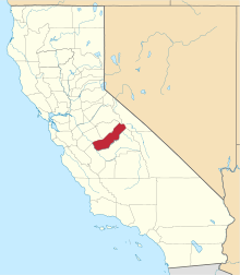
 Location in Madera County and the U.S. state of California | |
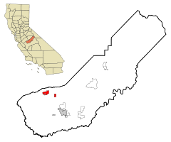
 Chowchilla, California Location in the United States | |
| Coordinates: 37°7′N 120°16′W / 37.117°N 120.267°WCoordinates: 37°7′N 120°16′W / 37.117°N 120.267°W | |
| Country |
|
| State |
|
| County |
|
| Incorporated | February 7, 1923[1] |
| Area[2] | |
| • Total | 7.661 sq mi (19.842 km2) |
| • Land | 7.661 sq mi (19.842 km2) |
| • Water | 0 sq mi (0 km2) 0% |
| Elevation[3] | 240 ft (73 m) |
| Population (2010) | |
| • Total | 18,720 |
| • Density | 2,400/sq mi (940/km2) |
| Time zone | Pacific (PST) (UTC-8) |
| • Summer (DST) | PDT (UTC-7) |
| ZIP code | 93610 |
| Area code(s) | 559 |
| FIPS code | 06-13294 |
| GNIS feature IDs | 277601, 2409459 |
| Website |
www |
Chowchilla is a city in Madera County, California.[3] The city's population was 18,720 at the 2010 United States Census, up from 11,127 at the 2000 U.S. Census. Chowchilla is located 15 miles (24 km) northwest of Madera,[4] at an elevation of 240 feet (73 m).[3] It is a principal city of the Madera–Chowchilla Metropolitan Statistical Area.[5]
The city is the location of two California Department of Corrections and Rehabilitation facilities, the Central California Women's Facility and Valley State Prison.
Etymology
The name "Chowchilla" is derived from the indigenous American tribe of Chaushila (the spelling is inconsistent in reference guides) Yokut Indians which once lived in the area. The name itself evidently translates as "Murderers" and is apparently a reference to the warlike nature of the Chaushila tribe. It is also to be known among the Yokuts tribes later on to be associated with "bravery". The Chaushila Indians were inadvertently responsible for the first white men "discovering" Yosemite Valley, which occurred when they were being pursued by a band of whites. References to the tribe still abound in Chowchilla, and the town's high school, up to 2016, used the moniker of "Redskins" as their local mascot.
History
The first post office at Chowchilla opened in 1912,[4] and the city incorporated eleven years later, in 1923.[4]
1976 bus kidnapping
Chowchilla made national news on July 15, 1976, when 26 students and their bus driver were kidnapped from a bus and held in a buried moving van at a quarry in Livermore, California. The driver and some of the students were able to escape and notify the quarry guard. All the victims returned unharmed. The quarry owner's son and two friends were convicted and sentenced to life in prison.[6]
Geography
Chowchilla is located at 37°7′N 120°16′W / 37.117°N 120.267°W.[3]
According to the United States Census Bureau, the city has a total area of 14,815 acres, all of it land.
Chowchila is 250 miles (400 km) north of Downtown Los Angeles.[7]
Climate
The climate of Chowchilla is Mediterranean. Chowchilla receives an average of about 12 inches of precipitation per year. The wettest months are January, February, and March with March being the wettest. Chowchilla has dry, hot summers, and mild to cool, rainy winters. Chowchilla experiences frequent fog from November to March and overcast days are common, especially in January. In 2005, Chowchilla had 20 consecutive cloudy, rainy days. There are days with moderate to heavy rain during the winter months. In January, the high temperature may drop as low as 45 °F (9 °C). During the summer, when there is usually no rain, the temperature may reach as high as 110 °F (43 °C). Snow in Chowchilla is rare.
Government and infrastructure

The city is the location of two California Department of Corrections and Rehabilitation facilities, the Central California Women's Facility and Valley State Prison.[8] Central California Women's houses the state's female death row.[9]

High-speed rail
Chowchilla Wye is planned to be the point where the California High-Speed Rail's main spine splits into two northern branches, one traveling to the San Francisco Bay Area, and the other continuing north to Merced.[10]
Education
Three public school districts serve the residents of Chowchilla and the surrounding area, as well as one private school. Chowchilla Elementary School District (Grades K to 8th), Alview-Dairyland Union School District (Grades K to 8th), and Chowchilla Union High School District (9th to 12th grade) make up the local public school system.
Chowchilla Elementary School District is made up of five school campuses and typically enrolls city residents, as well as residents from the nearby community of Fairmead. The Alview-Dairyland Union School District is composed of two rural area school campuses, and serves residents that reside outside of town. Upon completing 8th grade, students from both elementary districts are enrolled in the town's comprehensive high school, Chowchilla Union High School. The Chowchilla Union High School District also operates Gateway Continuation school and an Independent Study program.
The Chowchilla Elementary School District operates five schools,[11] with student population distributed by grade level. Stephens School [Kindergarten], Fuller School [Grades 1 and 2], Ronald Reagan School [Grades 3 and 4], and Fairmead School [Grades 5 and 6] are elementary schools, and Wilson School [Grades 7 and 8] is the middle school.
Alview-Dairyland Union School District operates Alview Elementary School [Grades K through 3] and Dairyland Elementary School [Grades 4 through 8].
There is also a private school, Chowchilla Seventh Day Adventist, serving K-8, located 4 miles south of town.
Notable people
Ronald D. Moore, American screenwriter and television producer best known for his work on Star Trek and the re-imagined Battlestar Galactica television series.
Craig E. Judd (1947-), American hall of fame pinstriping artist. Best known for his work for Disney and Muscle Machine toy company. Pinstriped numerous hot rods in movies such as American Graffiti and The Hollywood Knights.
Paul Scheet, APUSH teacher. Best known for his love of Teddy Roosevelt and broadcasting for SMRAMSTV.
Demographics
| Historical population | |||
|---|---|---|---|
| Census | Pop. | %± | |
| 1930 | 847 | — | |
| 1940 | 1,957 | 131.1% | |
| 1950 | 3,893 | 98.9% | |
| 1960 | 4,525 | 16.2% | |
| 1970 | 4,349 | −3.9% | |
| 1980 | 5,122 | 17.8% | |
| 1990 | 5,930 | 15.8% | |
| 2000 | 11,127 | 87.6% | |
| 2010 | 18,720 | 68.2% | |
| Est. 2015 | 18,510 | [12] | −1.1% |
Official population figures include inmates of both prisons.
2000
As of the census[14] of 2000, there were 11,127 people, 2,562 households, and 1,908 families residing in the city. The population density was 1,567.4 people per square mile (605.1/km²). There were 2,711 housing units at an average density of 381.9 per square mile (147.4/km²). The racial makeup of the city was 63.46% White, 10.26% Black or African American, 2.60% Native American, 1.32% Asian, 0.26% Pacific Islander, 16.16% from other races, and 5.94% from two or more races. 28.20% of the population were Hispanic or Latino of any race.
There were 2,562 households out of which 40.2% had children under the age of 18 living with them, 55.3% were married couples living together, 13.2% had a female householder with no husband present, and 25.5% were non-families. 21.9% of all households were made up of individuals and 12.6% had someone living alone who was 65 years of age or older. The average household size was 2.94 and the average family size was 3.42.
In the city the population was spread out with 22.2% under the age of 18, 9.4% from 18 to 24, 42.8% from 25 to 44, 16.2% from 45 to 64, and 9.3% who were 65 years of age or older. The median age was 34 years. For every 100 females there were 51.1 males. For every 100 females age 18 and over, there were 39.8 males.
The median income for a household in the city was $30,729, and the median income for a family was $35,741. Males had a median income of $32,306 versus $20,538 for females. The per capita income for the city was $11,927. About 16.5% of families and 19.2% of the population were below the poverty line, including 27.1% of those under age 18 and 7.6% of those age 65 or over.
2015
The 2015 United States Census[15] reported that Chowchilla had a population of 18,720, including the prisons' inmates. The population density was 2,443.5 people per square mile (943.4/km²). The racial makeup of Chowchilla was 11,533 (61.6%) White, 2,358 (12.6%) African American, 376 (2.0%) Native American, 395 (2.1%) Asian, 37 (0.2%) Pacific Islander, 3,313 (17.7%) from other races, and 708 (3.8%) from two or more races. Hispanic or Latino of any race were 7,073 persons (37.8%).
The Census reported that 11,311 people (60.4% of the population) lived in households, 6 (0%) lived in non-institutionalized group quarters, and 7,403 (39.5%) were institutionalized.
There were 3,673 households, out of which 1,693 (46.1%) had children under the age of 18 living in them, 1,932 (52.6%) were opposite-sex married couples living together, 586 (16.0%) had a female householder with no husband present, 260 (7.1%) had a male householder with no wife present. There were 275 (7.5%) unmarried opposite-sex partnerships, and 24 (0.7%) same-sex married couples or partnerships. 721 households (19.6%) were made up of individuals and 293 (8.0%) had someone living alone who was 65 years of age or older. The average household size was 3.08. There were 2,778 families (75.6% of all households); the average family size was 3.52.
The population was spread out with 3,583 people (19.1%) under the age of 18, 2,048 people (10.9%) aged 18 to 24, 7,343 people (39.2%) aged 25 to 44, 4,429 people (23.7%) aged 45 to 64, and 1,317 people (7.0%) who were 65 years of age or older. The median age was 34.7 years. For every 100 females there were 42.7 males. For every 100 females age 18 and over, there were 33.3 males.
There were 4,154 housing units at an average density of 542.2 per square mile (209.3/km²), of which 1,966 (53.5%) were owner-occupied, and 1,707 (46.5%) were occupied by renters. The homeowner vacancy rate was 6.2%; the rental vacancy rate was 7.9%. 5,920 people (31.6% of the population) lived in owner-occupied housing units and 5,391 people (28.8%) lived in rental housing units.
Politics
In the California State Legislature, Chowchilla is in the 12th Senate District, represented by Republican Anthony Cannella, and in the 5th Assembly District, represented by Republican Frank Bigelow.[16]
In the United States House of Representatives, Chowchilla is in California's 16th congressional district, represented by Democrat Jim Costa.[17]
References
- ↑ "California Cities by Incorporation Date". California Association of Local Agency Formation Commissions. Archived from the original (Word) on November 3, 2014. Retrieved August 25, 2014.
- ↑ "2010 Census Gazetteer Files - Places - California". United States Census Bureau. Retrieved March 26, 2015.
- 1 2 3 4 U.S. Geological Survey Geographic Names Information System: Chowchilla, California
- 1 2 3 Durham, David L. (1998). California's Geographic Names: A Gazetteer of Historic and Modern Names of the State. Clovis, Calif.: Word Dancer Press. p. 758. ISBN 1-884995-14-4.
- ↑ "Update of Statistical Area Definitions and Guidance on Their Uses (OMB Bulletin 09 - 01)" (CSV). Office of Management and Budget, Executive Office of the President. 2008-11-20. Retrieved 2008-12-17.
- ↑ MacGowan, Douglas. "The Chowchilla Kidnapping". crimelibrary. Archived from the original on April 3, 2014. Retrieved March 16, 2014.
- ↑ Bartholomew, Dana. "Last woman convicted in Missy Avila murder released from prison on Monday." Last woman convicted in Missy Avila murder released from prison on Monday]." Los Angeles Daily News. December 10, 2012. Retrieved on June 20, 2013.
- ↑ "Chowchilla city, California." U.S. Census Bureau. Retrieved on May 10, 2010.
- ↑ "History of Capital Punishment in California." California Department of Corrections. Retrieved on August 16, 2010. "All male prisoners on condemned status are housed at a maximum-security custody level in three units at San Quentin State Prison. Females are housed in a maximum-security unit at Central California Women’s Facility in Chowchilla."
- ↑ "Central Valley Wye". California High-Speed Rail Authority. Retrieved 2016-07-25.
- ↑ Chowchilla Elementary School District Website
- ↑ "Annual Estimates of the Resident Population for Incorporated Places: April 1, 2010 to July 1, 2015". Retrieved July 2, 2016.
- ↑ "Census of Population and Housing". Census.gov. Archived from the original on May 11, 2015. Retrieved June 4, 2015.
- ↑ "American FactFinder". United States Census Bureau. Archived from the original on 2013-09-11. Retrieved 2008-01-31.
- ↑ "2010 Census Interactive Population Search: CA - Chowchilla city". U.S. Census Bureau. Retrieved July 12, 2014.
- ↑ "Statewide Database". UC Regents. Retrieved December 1, 2014.
- ↑ "California's 16th Congressional District - Representatives & District Map". Civic Impulse, LLC.
External links
- Official website
- From Sun to Darkness — The Chowchilla Kidnapping
- Madera Online - News for Madera & Chowchilla
- Madera Values Quarterly