Delano, California
| Delano, California | ||
|---|---|---|
| City | ||
| City of Delano | ||
|
Main Street in downtown Delano | ||
| ||
 Location of Delano, California | ||
 Delano, California Location in the United States | ||
| Coordinates: 35°46′08″N 119°14′49″W / 35.76889°N 119.24694°WCoordinates: 35°46′08″N 119°14′49″W / 35.76889°N 119.24694°W[1] | ||
| Country |
| |
| State |
| |
| County | Kern | |
| Founded | 1869 | |
| Incorporated | 13 April 1915[2] | |
| Government | ||
| • City Council |
Mayor Grace Vallejo Mayor Pro Tem Rueben Pascual Joe Aguirre Ricardo Chavez Liz Morris[3] | |
| • State Senator | Andy Vidak (R)[4] | |
| • State Assembly | Rudy Salas (D)[5] | |
| • U. S. Congress | David Valadao (R)[6] | |
| Area[7] | ||
| • Total | 14.355 sq mi (37.180 km2) | |
| • Land | 14.303 sq mi (37.044 km2) | |
| • Water | 0.052 sq mi (0.135 km2) 0.36% | |
| Elevation[1] | 315 ft (96 m) | |
| Population (2015) | ||
| • Total | 52,088 | |
| • Density | 3,600/sq mi (1,400/km2) | |
| Time zone | PST (UTC-8) | |
| • Summer (DST) | PDT (UTC-7) | |
| ZIP codes | 93215, 93216 | |
| Area code(s) | 661 | |
| FIPS code | 06-18394 | |
| GNIS feature IDs | 1652697, 2410317 | |
| Website |
www | |
_(2012-01-29).jpg)

Delano (/dəˈleɪnoʊ/ də-LAY-noh) is a city in Kern County, California, United States. Delano is located 31 miles (50 km) north-northwest of Bakersfield[8] at an elevation of 315 feet (96 m).[1] The population was 62,088 in 2016, up from 38,824 in 2000. It is Kern County's second largest city after Bakersfield.
Agriculture is Delano's major industry. The area is particularly well known as a center for the growing of table grapes.[9] Delano is also home to two California state prisons, North Kern State Prison and Kern Valley State Prison. The Voice of America once operated its largest, most powerful shortwave broadcast facility outside Delano at 35°45′15″N 119°17′7″W / 35.75417°N 119.28528°W. However, the Voice of America ceased broadcasts in October 2007, citing a changing political mission, reduced budgets, and changes in technology.[10]
Delano's two school districts currently operate eight elementary schools, three middle schools, three comprehensive high schools and two alternative high schools. The city has its own police department and contracts with the Kern County Fire Department for fire services, EMS services are privately provided by local company, Delano Ambulance Service.
History
Delano was founded on July 14, 1869 as a railroad town. The name was officially given by the Southern Pacific Railroad in honor of Columbus Delano,[11] at the time the Secretary of the Interior for the United States. The first post office opened in 1874.[8] Delano incorporated in 1913.[8]
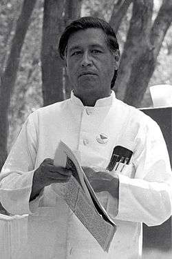
Delano was a major hub of farmworker organization efforts and Chicano movement politics. Filipino immigrants Philip Vera Cruz and Larry Dulay Itliong were instrumental in shaping the direction of farm worker movement in the 1950s.[12] On September 8, 1965, Larry Itliong and other Filipino leaders led the predominantly Filipino Agricultural Workers Organizing Committee (AWOC) in a "walk off" from table grape farms, now known as the Delano grape strike. The strikers' goal was to improve farmworkers' wages and working conditions. The National Farm Workers' Association (NFWA), a largely Hispanic union led by Cesar Chavez, joined the strike within a week. During the strike, the two groups joined forces and formed the United Farm Workers of America (UFW). By 1970, the UFW won a contract with major grape growers across California.
Delano is also known as "Crow Town" because of the many crows that roam there.
Economy
Major farm employers in Delano include Wonderful Citrus, Columbine Vineyards, Munger Farms, Lucich Farms, and Hronis. Other major employers include Delano Regional Medical Center, Walmart, Vallarta Supermarkets, Delano Joint Union High School District, Delano Union Elementary School District, Sears, Kmart, and the North Kern-South Tulare Hospital District.[13]
Geography
According to the United States Census Bureau, the city has a total area of 14.4 square miles (37 km2); over 99% of which is land.
Climate
| Delano, California | ||||||||||||||||||||||||||||||||||||||||||||||||||||||||||||
|---|---|---|---|---|---|---|---|---|---|---|---|---|---|---|---|---|---|---|---|---|---|---|---|---|---|---|---|---|---|---|---|---|---|---|---|---|---|---|---|---|---|---|---|---|---|---|---|---|---|---|---|---|---|---|---|---|---|---|---|---|
| Climate chart (explanation) | ||||||||||||||||||||||||||||||||||||||||||||||||||||||||||||
| ||||||||||||||||||||||||||||||||||||||||||||||||||||||||||||
| ||||||||||||||||||||||||||||||||||||||||||||||||||||||||||||
Delano's climate is characteristic of the San Joaquin Valley. The weather is hot and dry during the summer and cool and damp in winter. Frequent winter ground fog known regionally as tule fog can obscure vision. Record temperatures range between 115 °F (46 °C) (2006) and 14 °F (−10 °C) (1990). Delano is located within a desert climatic zone, receiving 7.51 in (191 mm) of rainfall annually.[15]
Demographics
| Historical population | |||
|---|---|---|---|
| Census | Pop. | %± | |
| 1920 | 805 | — | |
| 1930 | 2,632 | 227.0% | |
| 1940 | 4,573 | 73.7% | |
| 1950 | 8,717 | 90.6% | |
| 1960 | 11,913 | 36.7% | |
| 1970 | 14,559 | 22.2% | |
| 1980 | 16,491 | 13.3% | |
| 1990 | 22,762 | 38.0% | |
| 2000 | 38,824 | 70.6% | |
| 2010 | 53,041 | 36.6% | |
| Est. 2015 | 52,733 | [16] | −0.6% |
2010
The 2010 United States Census[18] reported that Delano had a population of 53,041. The population density was 3,694.9 people per square mile (1,426.6/km²). The racial makeup of Delano was 19,304 (36.4%) White, 4,191 (7.9%) African American, 501 (0.9%) Native American, 6,757 (12.7%) Asian, 30 (0.1%) Pacific Islander, 20,307 (38.3%) from other races, and 1,951 (3.7%) from two or more races. Hispanic or Latino of any race were 37,913 persons (71.5%).
The Census reported that 42,144 people (79.5% of the population) lived in households, 178 (0.3%) lived in non-institutionalized group quarters, and 10,719 (20.2%) were institutionalized.
There were 10,260 households, out of which 6,535 (63.7%) had children under the age of 18 living in them, 5,968 (58.2%) were opposite-sex married couples living together, 2,089 (20.4%) had a female householder with no husband present, 894 (8.7%) had a male householder with no wife present. There were 833 (8.1%) unmarried opposite-sex partnerships, and 61 (0.6%) same-sex married couples or partnerships. 990 households (9.6%) were made up of individuals and 424 (4.1%) had someone living alone who was 65 years of age or older. The average household size was 4.11. There were 8,951 families (87.2% of all households); the average family size was 4.31.
The population was spread out with 15,089 people (28.4%) under the age of 18, 7,813 people (14.7%) aged 18 to 24, 17,248 people (32.5%) aged 25 to 44, 9,644 people (18.2%) aged 45 to 64, and 3,247 people (6.1%) who were 65 years of age or older. The median age was 28.5 years. For every 100 females there were 149.1 males. For every 100 females age 18 and over, there were 172.3 males.
There were 10,713 housing units at an average density of 746.3 per square mile (288.1/km²), of which 5,764 (56.2%) were owner-occupied, and 4,496 (43.8%) were occupied by renters. The homeowner vacancy rate was 1.6%; the rental vacancy rate was 3.5%. 24,363 people (45.9% of the population) lived in owner-occupied housing units and 17,781 people (33.5%) lived in rental housing units.
2000
As of the census[19] of 2000, there were 38,824 people, 8,409 households, and 7,248 families residing in the city. The population density was 3,842.1 inhabitants per square mile (1,484.2/km²). There were 8,830 housing units at an average density of 873.8 per square mile (337.6/km²). The racial makeup of the city was 26.16% White, 5.45% Black or African American, 0.91% Native American, 15.88% Asian (primarily Filipino), 0.06% Pacific Islander, 47.07% from other races, and 4.47% from two or more races. 68.47% of the population were Hispanic or Latino of any race.
There were 8,409 households out of which 56.3% had children under the age of 18 living with them, 60.3% were married couples living together, 18.4% had a female householder with no husband present, and 13.8% were non-families. 10.8% of all households were made up of individuals and 5.4% had someone living alone who was 65 years of age or older. The average household size was 4.02 and the average family size was 4.27.
In the city the population was spread out with 32.5% under the age of 18, 12.4% from 18 to 24, 32.7% from 25 to 44, 14.9% from 45 to 64, and 7.5% who were 65 years of age or older. The median age was 28 years. For every 100 females there were 129.9 males. For every 100 females age 18 and over, there were 143.1 males.
The median income for a household in the city was $28,143, and the median income for a family was $29,026. Males had a median income of $38,511 versus $21,509 for females. The per capita income for the city was $11,068. About 25.7% of families and 28.2% of the population were below the poverty line, including 35.3% of those under age 18 and 20.7% of those age 65 or over.
Notable people

- Cesar E. Chavez, activist
- Dack Rambo, actor
- Larry Itliong, activist
- Harold H. Kelley, UCLA Professor of Psychology
- Leamon King, Olympic runner
- Lon Spurrier, Olympic runner
- Luis Valdez, film director, known for La Bamba
- Benita Valente, classical singer (soprano)
Events
Delano is home to an active and substantial Filipino American community, and the Annual Philippine Weekend fair takes place in Delano every July.[20]
Sister cities
Delano maintains a sister city relationship with the town of Arida, Wakayama, Japan.
See also
-
 California portal
References
- 1 2 3 "Delano". Geographic Names Information System. United States Geological Survey.
- ↑ "California Cities by Incorporation Date" (Word). California Association of Local Agency Formation Commissions. Retrieved 12 April 2013.
- ↑ "City Council". Delano, CA. Retrieved 12 April 2013.
- ↑ "Senators". State of California. Retrieved 12 April 2013.
- ↑ "Members Assembly". State of California. Retrieved 12 April 2013.
- ↑ "California's 21st Congressional District - Representatives & District Map". Civic Impulse, LLC. Retrieved 12 April 2013.
- ↑ U.S. Census Archived 2012-07-14 at WebCite
- 1 2 3 Durham, David L. (1998). California's Geographic Names: A Gazetteer of Historic and Modern Names of the State. Clovis, Calif.: Word Dancer Press. p. 1025. ISBN 1-884995-14-4.
- ↑ "Profile". Delano Chamber of Commerce. Retrieved 2009-07-12.
- ↑ "Broadcasting Board of Governors Strategic Spectrum Plan". Broadcasting Board of Governors. 2007-11-30. p. 9. Retrieved 2009-07-12.
- ↑ Gannett, Henry (1905). The Origin of Certain Place Names in the United States. Govt. Print. Off. p. 103.
- ↑ Salomon, Larry R. (2003). Roots of Justice. Josey-Bass. p. 10.
- ↑ Search Results - Delano, California - ReferenceUSA Current Businesses
- ↑ Delano Climate Graph, Temperature Graph, Climate Table—Climate-Data.org
- 1 2 Delano, California Climate Summary: NCDC 1981-2010 Monthly Normals—Western Regional Climate Center
- ↑ "Annual Estimates of the Resident Population for Incorporated Places: April 1, 2010 to July 1, 2015". Retrieved July 2, 2016.
- ↑ "Census of Population and Housing". Census.gov. Retrieved June 4, 2015.
- ↑ "2010 Census Interactive Population Search: CA - Delano city". U.S. Census Bureau. Retrieved July 12, 2014.
- ↑ "American FactFinder". United States Census Bureau. Retrieved 2008-01-31.
- ↑ http://philippineweekend.org/
External links
-
 Media related to Delano, California at Wikimedia Commons
 - Official website
-
 Delano travel guide from Wikivoyage
