West Hamlin, West Virginia
| West Hamlin, West Virginia | |
|---|---|
| Town | |
| Motto: Always Free | |
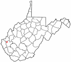 Location of West Hamlin, West Virginia | |
| Coordinates: 38°17′8″N 82°11′31″W / 38.28556°N 82.19194°WCoordinates: 38°17′8″N 82°11′31″W / 38.28556°N 82.19194°W | |
| Country | United States |
| State | West Virginia |
| County | Lincoln |
| Government | |
| • Type | Mayor- Farris Burton |
| • Recorder | Joanna Caldwell |
| • Water Sup. | Lonnie Wilson |
| Area[1] | |
| • Total | 0.55 sq mi (1.42 km2) |
| • Land | 0.53 sq mi (1.37 km2) |
| • Water | 0.02 sq mi (0.05 km2) |
| Elevation | 587 ft (179 m) |
| Population (2010)[2] | |
| • Total | 774 |
| • Estimate (2012[3]) | 767 |
| • Density | 1,460.4/sq mi (563.9/km2) |
| Time zone | Eastern (EST) (UTC-5) |
| • Summer (DST) | EDT (UTC-4) |
| ZIP code | 25571 |
| Area code(s) | 304 |
| FIPS code | 54-85804[4] |
| GNIS feature ID | 1548934[5] |
West Hamlin is a town in Lincoln County, West Virginia, United States, along the Guyandotte River. The population was 774 at the 2010 census. West Hamlin is a part of the Huntington-Ashland, WV-KY-OH, Metropolitan Statistical Area (MSA). As of the 2010 census, the MSA had a population of 287,702. New estimates from February 28, 2013 placed the population at 363,000.[6] West Hamlin is west of the county seat at Hamlin, hence the name.[7][8]
Geography
West Hamlin is located at 38°17′8″N 82°11′31″W / 38.28556°N 82.19194°W (38.285461, -82.191991).[9]
According to the United States Census Bureau, the town has a total area of 0.55 square miles (1.42 km2), of which, 0.53 square miles (1.37 km2) is land and 0.02 square miles (0.05 km2) is water.[1]
Demographics
| Historical population | |||
|---|---|---|---|
| Census | Pop. | %± | |
| 1950 | 793 | — | |
| 1960 | 788 | −0.6% | |
| 1970 | 715 | −9.3% | |
| 1980 | 643 | −10.1% | |
| 1990 | 423 | −34.2% | |
| 2000 | 696 | 64.5% | |
| 2010 | 774 | 11.2% | |
| Est. 2015 | 762 | [10] | −1.6% |
2010 census
As of the census[2] of 2010, there were 774 people, 356 households, and 211 families residing in the town. The population density was 1,460.4 inhabitants per square mile (563.9/km2). There were 395 housing units at an average density of 745.3 per square mile (287.8/km2). The racial makeup of the town was 98.3% White, 0.1% African American, and 1.6% from two or more races. Hispanic or Latino of any race were 0.9% of the population.
There were 356 households of which 30.9% had children under the age of 18 living with them, 41.3% were married couples living together, 14.6% had a female householder with no husband present, 3.4% had a male householder with no wife present, and 40.7% were non-families. 39.0% of all households were made up of individuals and 18.5% had someone living alone who was 65 years of age or older. The average household size was 2.17 and the average family size was 2.83.
The median age in the town was 42.6 years. 23% of residents were under the age of 18; 7.9% were between the ages of 18 and 24; 22.8% were from 25 to 44; 27.8% were from 45 to 64; and 18.5% were 65 years of age or older. The gender makeup of the town was 43.8% male and 56.2% female.
2000 census
As of the census[4] of 2000, there were 696 people, 305 households, and 190 families residing in the town. The population density was 1,278.9 inhabitants per square mile (497.6/km²). There were 335 housing units at an average density of 615.6 per square mile (239.5/km²). The racial makeup of the town was 99.14% White, and 0.86% from two or more races. Hispanic or Latino of any race were 0.72% of the population.
There were 305 households out of which 29.2% had children under the age of 18 living with them, 43.3% were married couples living together, 16.7% had a female householder with no husband present, and 37.4% were non-families. 35.1% of all households were made up of individuals and 19.7% had someone living alone who was 65 years of age or older. The average household size was 2.26 and the average family size was 2.88.
In the town the population was spread out with 25.1% under the age of 18, 6.8% from 18 to 24, 25.1% from 25 to 44, 24.7% from 45 to 64, and 18.2% who were 65 years of age or older. The median age was 40 years. For every 100 females there were 87.1 males. For every 100 females age 18 and over, there were 82.2 males.
The median income for a household in the town was $19,250, and the median income for a family was $27,308. Males had a median income of $32,857 versus $21,250 for females. The per capita income for the town was $13,072. About 28.9% of families and 35.4% of the population were below the poverty line, including 50.0% of those under age 18 and 31.5% of those age 65 or over.
References
- 1 2 "US Gazetteer files 2010". United States Census Bureau. Retrieved 2013-01-24.
- 1 2 "American FactFinder". United States Census Bureau. Retrieved 2013-01-24.
- ↑ "Population Estimates". United States Census Bureau. Retrieved 2013-06-26.
- 1 2 "American FactFinder". United States Census Bureau. Retrieved 2008-01-31.
- ↑ "US Board on Geographic Names". United States Geological Survey. 2007-10-25. Retrieved 2008-01-31.
- ↑ "Population statistics" (PDF).
- ↑ Capace, Nancy (1999). Encyclopedia of West Virginia. North American Book Dist LLC. p. 196. ISBN 978-0-403-09843-9.
- ↑ Kenny, Hamill (1945). West Virginia Place Names: Their Origin and Meaning, Including the Nomenclature of the Streams and Mountains. Piedmont, WV: The Place Name Press. p. 667.
- ↑ "US Gazetteer files: 2010, 2000, and 1990". United States Census Bureau. 2011-02-12. Retrieved 2011-04-23.
- ↑ "Annual Estimates of the Resident Population for Incorporated Places: April 1, 2010 to July 1, 2015". Retrieved July 2, 2016.
- ↑ "Census of Population and Housing". Census.gov. Retrieved June 4, 2015.
External links
Municipalities and communities of Lincoln County, West Virginia, United States | ||
|---|---|---|
| Towns | 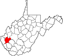 | |
| CDPs | ||
| Unincorporated communities |
| |
| Footnotes | ‡This populated place also has portions in an adjacent county or counties | |
| Principal cities | 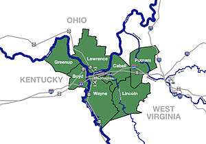 | |
|---|---|---|
| Municipalities with population over 5,000 | ||
| Municipalities with population 1,000–5,000 | ||
| Municipalities with population under 1,000 | ||
| West Virginia counties | ||
| Kentucky counties | ||
| Ohio counties | ||