West Logan, West Virginia
| West Logan, West Virginia | |
|---|---|
| Town | |
|
The Guyandotte River at West Logan | |
 Location of West Logan, West Virginia | |
| Coordinates: 37°52′10″N 81°59′14″W / 37.86944°N 81.98722°WCoordinates: 37°52′10″N 81°59′14″W / 37.86944°N 81.98722°W | |
| Country | United States |
| State | West Virginia |
| County | Logan |
| Area[1] | |
| • Total | 0.34 sq mi (0.88 km2) |
| • Land | 0.34 sq mi (0.88 km2) |
| • Water | 0 sq mi (0 km2) |
| Elevation | 682 ft (208 m) |
| Population (2010)[2] | |
| • Total | 424 |
| • Estimate (2012[3]) | 418 |
| • Density | 1,247.1/sq mi (481.5/km2) |
| Time zone | Eastern (EST) (UTC-5) |
| • Summer (DST) | EDT (UTC-4) |
| ZIP code | 25601 |
| Area code(s) | 304 |
| FIPS code | 54-85900[4] |
| GNIS feature ID | 1555948[5] |
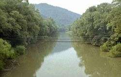
West Logan is a town in Logan County, West Virginia, United States, along the Guyandotte River. The population was 424 at the 2010 census. West Logan is west of the county seat at Logan, hence the name.[6]
Geography
West Logan is located at 37°52′10″N 81°59′14″W / 37.869557°N 81.987282°W (37.869557, -81.987282).[7]
According to the United States Census Bureau, the town has a total area of 0.34 square miles (0.88 km2), all of it land.[1]
Demographics
| Historical population | |||
|---|---|---|---|
| Census | Pop. | %± | |
| 1960 | 855 | — | |
| 1970 | 685 | −19.9% | |
| 1980 | 630 | −8.0% | |
| 1990 | 524 | −16.8% | |
| 2000 | 418 | −20.2% | |
| 2010 | 424 | 1.4% | |
| Est. 2015 | 400 | [8] | −5.7% |
2010 census
As of the census[2] of 2010, there were 424 people, 188 households, and 109 families residing in the town. The population density was 1,247.1 inhabitants per square mile (481.5/km2). There were 221 housing units at an average density of 650.0 per square mile (251.0/km2). The racial makeup of the town was 97.4% White, 0.2% African American, 0.9% Asian, and 1.4% from two or more races.
There were 188 households of which 27.7% had children under the age of 18 living with them, 37.8% were married couples living together, 14.4% had a female householder with no husband present, 5.9% had a male householder with no wife present, and 42.0% were non-families. 38.3% of all households were made up of individuals and 18.7% had someone living alone who was 65 years of age or older. The average household size was 2.26 and the average family size was 2.99.
The median age in the town was 38.8 years. 21.7% of residents were under the age of 18; 8.8% were between the ages of 18 and 24; 26.9% were from 25 to 44; 24.8% were from 45 to 64; and 17.9% were 65 years of age or older. The gender makeup of the town was 46.2% male and 53.8% female.
2000 census
As of the census[4] of 2000, there were 418 people, 186 households, and 124 families residing in the town. The population density was 1,236.6 inhabitants per square mile (474.7/km2). There were 228 housing units at an average density of 674.5 per square mile (258.9/km2). The racial makeup of the town was 97.13% White, 1.67% African American, 0.72% Native American, 0.24% Asian, and 0.24% from two or more races.
There were 186 households out of which 21.5% had children under the age of 18 living with them, 52.7% were married couples living together, 11.3% had a female householder with no husband present, and 33.3% were non-families. 30.6% of all households were made up of individuals and 18.3% had someone living alone who was 65 years of age or older. The average household size was 2.25 and the average family size was 2.82.
In the town the population was spread out with 20.6% under the age of 18, 5.0% from 18 to 24, 22.2% from 25 to 44, 27.5% from 45 to 64, and 24.6% who were 65 years of age or older. The median age was 46 years. For every 100 females there were 85.0 males. For every 100 females age 18 and over, there were 83.4 males.
The median income for a household in the town was $23,500, and the median income for a family was $30,833. Males had a median income of $28,125 versus $22,917 for females. The per capita income for the town was $13,567. About 21.3% of families and 22.0% of the population were below the poverty line, including 29.7% of those under age 18 and 12.5% of those age 65 or over.
References
- 1 2 "US Gazetteer files 2010". United States Census Bureau. Retrieved 2013-01-24.
- 1 2 "American FactFinder". United States Census Bureau. Retrieved 2013-01-24.
- ↑ "Population Estimates". United States Census Bureau. Retrieved 2013-06-26.
- 1 2 "American FactFinder". United States Census Bureau. Retrieved 2008-01-31.
- ↑ "US Board on Geographic Names". United States Geological Survey. 2007-10-25. Retrieved 2008-01-31.
- ↑ Capace, Nancy (1999). Encyclopedia of West Virginia. North American Book Dist LLC. p. 197. ISBN 978-0-403-09843-9.
- ↑ "US Gazetteer files: 2010, 2000, and 1990". United States Census Bureau. 2011-02-12. Retrieved 2011-04-23.
- ↑ "Annual Estimates of the Resident Population for Incorporated Places: April 1, 2010 to July 1, 2015". Retrieved July 2, 2016.
- ↑ "Census of Population and Housing". Census.gov. Retrieved June 4, 2015.