Fayetteville, West Virginia
| Fayetteville, West Virginia | |
|---|---|
| Town | |
|
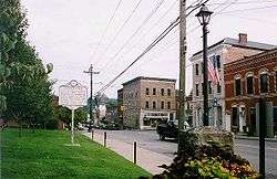
Court Street in downtown Fayetteville | |
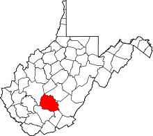
 Location of Fayetteville, West Virginia | |
| Coordinates: 38°3′4″N 81°6′25″W / 38.05111°N 81.10694°WCoordinates: 38°3′4″N 81°6′25″W / 38.05111°N 81.10694°W | |
| Country | United States |
| State | West Virginia |
| County | Fayette |
| Area[1] | |
| • Total | 5.47 sq mi (14.17 km2) |
| • Land | 5.46 sq mi (14.14 km2) |
| • Water | 0.01 sq mi (0.03 km2) |
| Elevation | 1,818 ft (554 m) |
| Population (2010)[2] | |
| • Total | 2,892 |
| • Estimate (2012[3]) | 2,890 |
| • Density | 529.7/sq mi (204.5/km2) |
| Time zone | Eastern (EST) (UTC-5) |
| • Summer (DST) | EDT (UTC-4) |
| ZIP code | 25840 |
| Area code(s) | 304 |
| FIPS code | 54-27028[4] |
| GNIS feature ID | 1538910[5] |
Fayetteville is a town in and the county seat of Fayette County, West Virginia, United States.[6] The population was 2,892 at the 2010 census.
Fayetteville was listed as one of the 2006 "Top 10 Coolest Small Towns in America" by Budget Travel Magazine,[7] and as "Best River Town 2013" by Blue Ridge Outdoors magazine.[8]
History
Fayetteville was originally founded by Abraham Vandal, a Revolutionary War veteran and local farmer. The town was originally named Vandalia. The Fayette County Courthouse is located on part of the original Vandal farm. The town’s name was later (prior to 1837) changed to Fayetteville after the Revolutionary War hero, Marquis de Lafayette who toured the US in 1824/25.
During the Civil War, the majority of the people in Fayetteville were in sympathy with the Southern cause. Fayetteville changed hands several times during the war and was partially destroyed during the fighting.
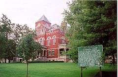
In 1897, the Fayette County Courthouse was completed and is a remarkable example of the Romanesque Revival architectural style. The Altamont Hotel was built the same year. Both are listed on the National Register of Historic Places, along with the E. B. Hawkins House. The Fayetteville Historic District was designated in 1990.[9]
Fayetteville grew rapidly in the late 19th century thanks mainly to the coal industry. The mining industry declined in the late 20th century. Fayetteville’s economy now is almost completely based on the tourism industry. Popular activities include white water rafting, fishing, mountain biking, and rock climbing in the region. Also, the New River Gorge Bridge hosts annual celebration, "Bridge Day," which is held on the third Saturday of October.
The New River Gorge Bridge is the longest arch bridge in the western hemisphere; its creation made traveling on US 19 much easier, turning a 45-minute sojourn from one side of the gorge to the other into a roughly 45-second jaunt. The New River is one of the five oldest major rivers in the world.
Geography
Fayetteville is located at 38°3′4″N 81°6′25″W / 38.05111°N 81.10694°W (38.051181, -81.106961).[10]
According to the United States Census Bureau, the town has a total area of 5.47 square miles (14.17 km2), of which, 5.46 square miles (14.14 km2) is land and 0.01 square miles (0.03 km2) is water.[1]
Located less than a mile away from Fayetteville is the New River Gorge, which attracts outdoor recreation enthusiasts. The scenic cliffs that line the New River Gorge are popular for rock climbing. The New River offers Class I-IV whitewater rafting and kayaking. Hiking and biking trails in the area are also available. The New River Gorge National River, managed by the U.S. National Park Service, operates a visitors center and offers many educational programs in the area.
Demographics
| Historical population | |||
|---|---|---|---|
| Census | Pop. | %± | |
| 1900 | 413 | — | |
| 1910 | 671 | 62.5% | |
| 1920 | 659 | −1.8% | |
| 1930 | 1,143 | 73.4% | |
| 1940 | 1,347 | 17.8% | |
| 1950 | 1,952 | 44.9% | |
| 1960 | 1,848 | −5.3% | |
| 1970 | 1,712 | −7.4% | |
| 1980 | 2,366 | 38.2% | |
| 1990 | 2,182 | −7.8% | |
| 2000 | 2,754 | 26.2% | |
| 2010 | 2,892 | 5.0% | |
| Est. 2015 | 2,892 | [11] | 0.0% |
2010 census
As of the census[2] of 2010, there were 2,892 people, 1,245 households, and 813 families residing in the town. The population density was 529.7 inhabitants per square mile (204.5/km2). There were 1,366 housing units at an average density of 250.2 per square mile (96.6/km2). The racial makeup of the town was 95.8% White, 3.0% African American, 0.2% Native American, 0.2% Asian, 0.1% from other races, and 0.7% from two or more races. Hispanic or Latino of any race were 1.6% of the population.
There were 1,245 households of which 26.7% had children under the age of 18 living with them, 49.0% were married couples living together, 12.5% had a female householder with no husband present, 3.8% had a male householder with no wife present, and 34.7% were non-families. 29.2% of all households were made up of individuals and 13.1% had someone living alone who was 65 years of age or older. The average household size was 2.29 and the average family size was 2.79.
The median age in the town was 44.4 years. 19.7% of residents were under the age of 18; 6.6% were between the ages of 18 and 24; 24.3% were from 25 to 44; 30.9% were from 45 to 64; and 18.5% were 65 years of age or older. The gender makeup of the town was 48.3% male and 51.7% female.
2000 census
As of the census[4] of 2000, there were 2,754 people, 1,151 households, and 766 families residing in the town. The population density was 934.8 people per square mile (360.4/km²). There were 1,257 housing units at an average density of 426.7 per square mile (164.5/km²). The racial makeup of the town was 94.88% White, 4.58% African American, 0.15% Native American, 0.04% Asian, 0.04% Pacific Islander, 0.18% from other races, and 0.15% from two or more races. Hispanic or Latino of any race were 0.62% of the population.
There were 1,151 households out of which 27.9% had children under the age of 18 living with them, 53.2% were married couples living together, 10.7% had a female householder with no husband present, and 33.4% were non-families. 29.5% of all households were made up of individuals and 16.2% had someone living alone who was 65 years of age or older. The average household size was 2.29 and the average family size was 2.82.
In the town the population was spread out with 20.4% under the age of 18, 7.1% from 18 to 24, 26.1% from 25 to 44, 26.4% from 45 to 64, and 20.0% who were 65 years of age or older. The median age was 43 years. For every 100 females there were 84.5 males. For every 100 females age 18 and over, there were 79.3 males.
The median income for a household in the town was $35,043, and the median income for a family was $44,444. Males had a median income of $35,603 versus $20,909 for females. The per capita income for the town was $18,710. About 9.5% of families and 11.7% of the population were below the poverty line, including 13.7% of those under age 18 and 16.1% of those age 65 or over.
Notable people
- Tunney Hunsaker - Professional boxer and longtime Fayetteville police chief
- The five Sodder children – Pronounced dead after a fire destroyed the family home on Christmas Eve 1945, their parents and all but one surviving sibling came to believe they had instead disappeared. They erected a billboard on the outskirts of town to publicize the reward they offered for information that would resolve the case.
References
- 1 2 "US Gazetteer files 2010". United States Census Bureau. Archived from the original on January 24, 2012. Retrieved 2013-01-24.
- 1 2 "American FactFinder". United States Census Bureau. Retrieved 2013-01-24.
- ↑ "Population Estimates". United States Census Bureau. Archived from the original on June 17, 2013. Retrieved 2013-06-26.
- 1 2 "American FactFinder". United States Census Bureau. Retrieved 2008-01-31.
- ↑ "US Board on Geographic Names". United States Geological Survey. 2007-10-25. Retrieved 2008-01-31.
- ↑ "Find a County". National Association of Counties. Archived from the original on May 10, 2015. Retrieved 2011-06-07.
- ↑ Fayetteville, West Virginia | Travel Deals, Travel Tips, Travel Advice, Vacation Ideas | Budget Travel
- ↑ Best River Town 2013: Fayetteville, West Virginia
- ↑ National Park Service (2010-07-09). "National Register Information System". National Register of Historic Places. National Park Service.
- ↑ "US Gazetteer files: 2010, 2000, and 1990". United States Census Bureau. 2011-02-12. Retrieved 2011-04-23.
- ↑ "Annual Estimates of the Resident Population for Incorporated Places: April 1, 2010 to July 1, 2015". Retrieved July 2, 2016.
- ↑ "Census of Population and Housing". Census.gov. Archived from the original on May 11, 2015. Retrieved June 4, 2015.
External links
 Fayetteville, West Virginia travel guide from Wikivoyage