Glenville, West Virginia
| Glenville, West Virginia | |
|---|---|
| Town | |
|
Main Street in Glenville in 2006 | |
 Location of Glenville, West Virginia | |
| Coordinates: 38°56′7″N 80°50′14″W / 38.93528°N 80.83722°WCoordinates: 38°56′7″N 80°50′14″W / 38.93528°N 80.83722°W | |
| Country | United States |
| State | West Virginia |
| County | Gilmer |
| Government | |
| • Mayor | Dennis Fitzpatrick |
| Area[1] | |
| • Total | 1.04 sq mi (2.69 km2) |
| • Land | 1.00 sq mi (2.59 km2) |
| • Water | 0.04 sq mi (0.10 km2) |
| Elevation | 725 ft (221 m) |
| Population (2010)[2] | |
| • Total | 1,537 |
| • Estimate (2012[3]) | 1,551 |
| • Density | 1,537.0/sq mi (593.4/km2) |
| Time zone | Eastern (EST) (UTC-5) |
| • Summer (DST) | EDT (UTC-4) |
| ZIP code | 26351 |
| Area code(s) | 304 |
| FIPS code | 54-32044[4] |
| GNIS feature ID | 1539468[5] |


Glenville is a town in and the county seat of Gilmer County, West Virginia, United States,[6] along the Little Kanawha River. The population was 1,537 at the 2010 census. It is the home of Glenville State College.
History
In the late 1700s and early 1800s, pioneers began settling in the area they called ‘‘the Ford’’ because it was a place where travelers could cross the river. Later, the community was named Glenville because of its location in a glen. The first grist mill in Gilmer County was constructed there in 1812. The first courthouse was completed in 1850, the second in 1872, and the current courthouse in 1923. Glenville was incorporated in 1856.[7]
Before the 1930s, the Little Kanawha River’s commercial traffic dominated the town’s economy. Road construction contributed to the demise of riverboating by the late 1930s. The natural gas and oil industry rose to prominence after oil was struck in 1875 at nearby Letter Gap. Glenville is now the headquarters of several oil and gas firms. The 1985 flood devastated the downtown, leading many businesses to move to the higher Hays City neighborhood at the main highway intersection.[7]
The Little Kanawha Valley Bank was incorporated in 1901. Its small frame building, covered in pressed metal, is now on the National Register of Historic Places. By 1906, the First National Bank of Glenville and the Glenville Banking and Trust Company had also been created. Glenville is now served by United Bank and a branch of Calhoun Banks of Grantsville.[7]
Early Methodist circuit riders and Baptist missionaries brought religion to Glenville early in the 19th century. The Presbyterian Church was organized in 1847; the First Baptist Church, 1850; and Trinity United Methodist Church, 1896. Several other churches also serve the area today. Glenville has a golf club and recreation center, among several other facilities built at the old county poor farm.[7]
In 1885, the Glenville Crescent first published Ellen King’s poem, ‘‘The West Virginia Hills,’’ which later became the official state song. While this newspaper didn’t survive, the Glenville Pathfinder (1892) and the Glenville Democrat (1904) have.[7]
The flood of 1985 devastated all of Glenville. A late season tropical storm named Juan moved North leaving abundant moisture over the Southeast. On Sunday, November 3, another storm formed in Southeastern Georgia. This new storm tapped into the moisture left by Juan. By November 4, a large area of rain began to form from the Western North Carolina to Southern West Virginia. The storm's center slowly moved North, and soon, engulfed all of Glenville. Rainfall rates of 3 to 6 inches in 12 hours were observed over the headwaters of the Potomac, Greenbrier, and Little Kanawha rivers.
On Monday night, November 5, severe flooding took place and by midnight the rain became lighter, but it was too late, fatal flooding had begun. All of Down-Town Glenville was rocked. Stores were closed, and shops were flooded. Shopkeepers attempted to save their stock by piling sandbags up to stop the water, but their futile attempts to save their stores were mocked by the savagery of this new storm. In the end, 47 lives were lost to this horrible natural disaster.[8] Most of the deaths were in rural Pendleton County and Grant County, according to the National Weather Service.[9]
Geography
Glenville is located at 38°56′7″N 80°50′14″W / 38.93528°N 80.83722°W (38.935405, -80.837114).[10]
According to the United States Census Bureau, the town has a total area of 1.04 square miles (2.69 km2), of which, 1.00 square mile (2.59 km2) is land and 0.04 square miles (0.10 km2) is water.[1]
Demographics
| Historical population | |||
|---|---|---|---|
| Census | Pop. | %± | |
| 1860 | 398 | — | |
| 1870 | 174 | −56.3% | |
| 1880 | 236 | 35.6% | |
| 1890 | 329 | 39.4% | |
| 1900 | 398 | 21.0% | |
| 1910 | 336 | −15.6% | |
| 1920 | 327 | −2.7% | |
| 1930 | 799 | 144.3% | |
| 1940 | 588 | −26.4% | |
| 1950 | 1,789 | 204.3% | |
| 1960 | 1,828 | 2.2% | |
| 1970 | 2,183 | 19.4% | |
| 1980 | 2,155 | −1.3% | |
| 1990 | 1,923 | −10.8% | |
| 2000 | 1,544 | −19.7% | |
| 2010 | 1,537 | −0.5% | |
| Est. 2015 | 1,543 | [11] | 0.4% |
2010 census
As of the census[2] of 2010, there were 1,537 people, 540 households, and 250 families residing in the town. The population density was 1,537.0 inhabitants per square mile (593.4/km2). There were 624 housing units at an average density of 624.0 per square mile (240.9/km2). The racial makeup of the town was 90.0% White, 6.3% African American, 0.3% Native American, 0.3% Asian, 0.5% Pacific Islander, 0.5% from other races, and 2.1% from two or more races. Hispanic or Latino of any race were 2.1% of the population.
There were 540 households of which 22.2% had children under the age of 18 living with them, 29.4% were married couples living together, 12.0% had a female householder with no husband present, 4.8% had a male householder with no wife present, and 53.7% were non-families. 36.5% of all households were made up of individuals and 8.3% had someone living alone who was 65 years of age or older. The average household size was 2.15 and the average family size was 2.91.
The median age in the town was 24 years. 14.1% of residents were under the age of 18; 38.1% were between the ages of 18 and 24; 20.5% were from 25 to 44; 15.7% were from 45 to 64; and 11.5% were 65 years of age or older. The gender makeup of the town was 53.0% male and 47.0% female.
2000 census
As of the census[4] of 2000, there were 1,544 people, 527 households, and 235 families residing in the town. The population density was 1,428.7 inhabitants per square mile (552.0/km²). There were 654 housing units at an average density of 605.2 per square mile (233.8/km²). The racial makeup of the town was 92.75% White, 3.17% African American, 0.13% Native American, 2.40% Asian, 0.26% from other races, and 1.30% from two or more races. Hispanic or Latino of any race were 0.58% of the population.
There were 527 households out of which 17.6% had children under the age of 18 living with them, 31.1% were married couples living together, 9.1% had a female householder with no husband present, and 55.4% were non-families. 36.8% of all households were made up of individuals and 12.9% had someone living alone who was 65 years of age or older. The average household size was 2.10 and the average family size was 2.82.
In the town the population was spread out with 11.9% under the age of 18, 43.1% from 18 to 24, 16.1% from 25 to 44, 14.5% from 45 to 64, and 14.4% who were 65 years of age or older. The median age was 23 years. For every 100 females there were 101.0 males. For every 100 females age 18 and over, there were 105.1 males.
The median income for a household in the town was $20,243, and the median income for a family was $33,036. Males had a median income of $24,583 versus $18,375 for females. The per capita income for the town was $10,304. About 21.5% of families and 38.5% of the population were below the poverty line, including 44.9% of those under age 18 and 13.8% of those age 65 or over.
Education
As early as 1833, a high school was established in the Methodist Episcopal Church. After moving to the courthouse in 1850 and into a house in 1884, the school got its own building in 1913. Glenville High School was replaced by the consolidated Gilmer County High School in 1968. What is now Glenville State College was founded in 1872.[7]
Culture
In 1950, folklorist Patrick Gainer established the West Virginia State Folk Festival at the college.[7] It has been held each June since then, making it one of the two oldest such events in the United States.
Climate
The climate in this area is characterized by hot, humid summers and generally mild to cool winters. According to the Köppen Climate Classification system, Glenville has a humid subtropical climate, abbreviated "Cfa" on climate maps.[13]
References
- 1 2 "US Gazetteer files 2010". United States Census Bureau. Archived from the original on January 24, 2012. Retrieved 2013-01-24.
- 1 2 "American FactFinder". United States Census Bureau. Retrieved 2013-01-24.
- ↑ "Population Estimates". United States Census Bureau. Archived from the original on June 17, 2013. Retrieved 2013-06-26.
- 1 2 "American FactFinder". United States Census Bureau. Retrieved 2008-01-31.
- ↑ "US Board on Geographic Names". United States Geological Survey. 2007-10-25. Retrieved 2008-01-31.
- ↑ "Find a County". National Association of Counties. Archived from the original on May 31, 2011. Retrieved 2011-06-07.
- 1 2 3 4 5 6 7 David H. Corcoran (n.d.). "The West Virginia Encyclopedia: Glenville". West Virginia Humanities Council. Retrieved 2011-07-23.
- ↑ "e-WV - Flood of 1985".
- ↑ West Virginia Gazette: "Remembering the '85 floods" (D. White) 4 Nov 2010
- ↑ "US Gazetteer files: 2010, 2000, and 1990". United States Census Bureau. 2011-02-12. Retrieved 2011-04-23.
- ↑ "Annual Estimates of the Resident Population for Incorporated Places: April 1, 2010 to July 1, 2015". Retrieved July 2, 2016.
- ↑ "Census of Population and Housing". Census.gov. Archived from the original on May 11, 2015. Retrieved June 4, 2015.
- ↑ "Glenville, West Virginia Köppen Climate Classification (Weatherbase)".
External links
- Glenville Democrat and Pathfinder (local newspaper)
- West Virginia State Folk Festival
- Self Suds Laundromat (Super Clean!)
Municipalities and communities of Gilmer County, West Virginia, United States | ||
|---|---|---|
| Towns | 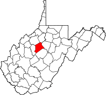 | |
| Unincorporated communities | ||
| Footnotes | ‡This populated place also has portions in an adjacent county or counties | |