Matoaka, West Virginia
| Matoaka, West Virginia | |
|---|---|
| Town | |
|
Matoaka | |
 Location in Mercer County and the state of West Virginia. | |
| Coordinates: 37°25′7″N 81°14′31″W / 37.41861°N 81.24194°WCoordinates: 37°25′7″N 81°14′31″W / 37.41861°N 81.24194°W | |
| Country | United States |
| State | West Virginia |
| County | Mercer |
| Area[1] | |
| • Total | 0.26 sq mi (0.67 km2) |
| • Land | 0.26 sq mi (0.67 km2) |
| • Water | 0 sq mi (0 km2) |
| Elevation | 2,359 ft (719 m) |
| Population (2010)[2] | |
| • Total | 227 |
| • Estimate (2012[3]) | 222 |
| • Density | 873.1/sq mi (337.1/km2) |
| Time zone | Eastern (EST) (UTC-5) |
| • Summer (DST) | EDT (UTC-4) |
| ZIP code | 24736 |
| Area code(s) | 304 |
| FIPS code | 54-52420[4] |
| GNIS feature ID | 1542868[5] |

Matoaka is a small town in Mercer County, West Virginia, United States. The population was 227 at the 2010 census. It is part of the Bluefield, WV-VA micropolitan area which has a population of 107,578. This town is named for Chief Powhatan's daughter Matoaka who was better known by her nickname "Pocahontas".[6]
Geography
Matoaka is located at 37°25′7″N 81°14′31″W / 37.41861°N 81.24194°W (37.418741, -81.242028).[7]
According to the United States Census Bureau, the town has a total area of 0.26 square miles (0.67 km2), all land.[1]
Climate
The climate in this area has mild differences between highs and lows, and there is adequate rainfall year round. According to the Köppen Climate Classification system, Matoaka has a marine west coast climate, abbreviated "Cfb" on climate maps.[8]
Demographics
| Historical population | |||
|---|---|---|---|
| Census | Pop. | %± | |
| 1920 | 647 | — | |
| 1930 | 929 | 43.6% | |
| 1940 | 926 | −0.3% | |
| 1950 | 1,003 | 8.3% | |
| 1960 | 613 | −38.9% | |
| 1970 | 608 | −0.8% | |
| 1980 | 613 | 0.8% | |
| 1990 | 366 | −40.3% | |
| 2000 | 317 | −13.4% | |
| 2010 | 227 | −28.4% | |
| Est. 2015 | 220 | [9] | −3.1% |
2010 census
As of the census[2] of 2010, there were 227 people, 87 households, and 60 families residing in the town. The population density was 873.1 inhabitants per square mile (337.1/km2). There were 145 housing units at an average density of 557.7 per square mile (215.3/km2). The racial makeup of the town was 98.7% White, 0.4% African American, and 0.9% Asian.
There were 87 households of which 35.6% had children under the age of 18 living with them, 55.2% were married couples living together, 8.0% had a female householder with no husband present, 5.7% had a male householder with no wife present, and 31.0% were non-families. 24.1% of all households were made up of individuals and 12.6% had someone living alone who was 65 years of age or older. The average household size was 2.61 and the average family size was 3.12.
The median age in the town was 40.2 years. 26.4% of residents were under the age of 18; 7% were between the ages of 18 and 24; 22.5% were from 25 to 44; 25% were from 45 to 64; and 18.9% were 65 years of age or older. The gender makeup of the town was 50.2% male and 49.8% female.
2000 census
As of the census[4] of 2000, there were 317 people, 125 households, and 93 families residing in the town. The population density was 1,181.9 inhabitants per square mile (453.3/km²). There were 155 housing units at an average density of 577.9 per square mile (221.7/km²). The racial makeup of the town was 98.74% White, 0.32% Asian, and 0.95% from two or more races.
There were 125 households out of which 30.4% had children under the age of 18 living with them, 48.0% were married couples living together, 20.0% had a female householder with no husband present, and 25.6% were non-families. 23.2% of all households were made up of individuals and 16.8% had someone living alone who was 65 years of age or older. The average household size was 2.49 and the average family size was 2.89.
In the town the population was spread out with 26.8% under the age of 18, 5.4% from 18 to 24, 26.2% from 25 to 44, 21.8% from 45 to 64, and 19.9% who were 65 years of age or older. The median age was 36 years. For every 100 females there were 77.1 males. For every 100 females age 18 and over, there were 82.7 males.
The median income for a household in the town was $17,159, and the median income for a family was $19,792. Males had a median income of $25,000 versus $13,750 for females. The per capita income for the town was $9,522. About 28.0% of families and 29.5% of the population were below the poverty line, including 43.9% of those under age 18 and 14.9% of those age 65 or over.
References
- 1 2 "US Gazetteer files 2010". United States Census Bureau. Retrieved 2013-01-24.
- 1 2 "American FactFinder". United States Census Bureau. Retrieved 2013-01-24.
- ↑ "Population Estimates". United States Census Bureau. Retrieved 2013-06-26.
- 1 2 "American FactFinder". United States Census Bureau. Retrieved 2008-01-31.
- ↑ "US Board on Geographic Names". United States Geological Survey. 2007-10-25. Retrieved 2008-01-31.
- ↑ Kenny, Hamill (1945). West Virginia Place Names: Their Origin and Meaning, Including the Nomenclature of the Streams and Mountains. Piedmont, WV: The Place Name Press. p. 406.
- ↑ "US Gazetteer files: 2010, 2000, and 1990". United States Census Bureau. 2011-02-12. Retrieved 2011-04-23.
- ↑ Climate Summary for Matoaka, West Virginia
- ↑ "Annual Estimates of the Resident Population for Incorporated Places: April 1, 2010 to July 1, 2015". Retrieved July 2, 2016.
- ↑ "Census of Population and Housing". Census.gov. Retrieved June 4, 2015.
Municipalities and communities of Mercer County, West Virginia, United States | ||
|---|---|---|
| Cities | 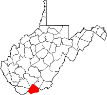 | |
| Towns | ||
| CDPs | ||
| Other communities |
| |
| Ghost town | ||
| Footnotes | ‡This populated place also has portions in an adjacent county or counties | |