New Cumberland, West Virginia
| New Cumberland, West Virginia | |
|---|---|
| City | |
|
| |
 Location of New Cumberland, West Virginia | |
| Coordinates: 40°29′57″N 80°36′29″W / 40.49917°N 80.60806°WCoordinates: 40°29′57″N 80°36′29″W / 40.49917°N 80.60806°W | |
| Country | United States |
| State | West Virginia |
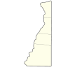
| County | Hancock |
| Area[1] | |
| • Total | 1.86 sq mi (4.82 km2) |
| • Land | 1.22 sq mi (3.16 km2) |
| • Water | 0.64 sq mi (1.66 km2) |
| Elevation | 722 ft (220 m) |
| Population (2010)[2] | |
| • Total | 1,103 |
| • Estimate (2012[3]) | 1,087 |
| • Density | 904.1/sq mi (349.1/km2) |
| Time zone | Eastern (EST) (UTC-5) |
| • Summer (DST) | EDT (UTC-4) |
| ZIP code | 26047 |
| Area code(s) | 304 |
| FIPS code | 54-58372[4] |
| GNIS feature ID | 1555205[5] |

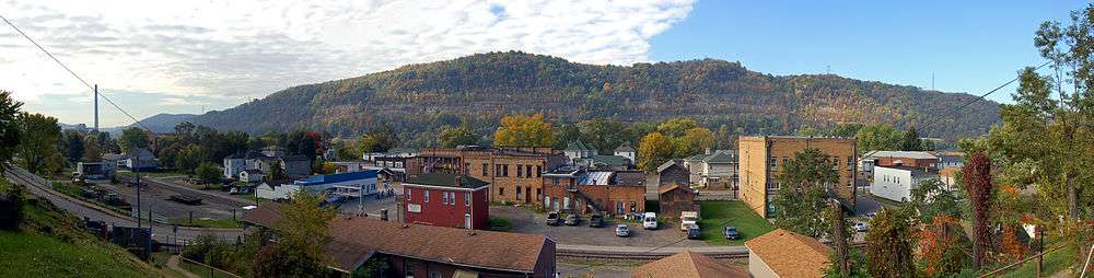
New Cumberland is a city in and the county seat of Hancock County, West Virginia, United States,[6] along the Ohio River. It is part of the Weirton-Steubenville, WV-OH Metropolitan Statistical Area, a subsection of the Pittsburgh Tri-State. The population was 1,103 as of the 2010 census. It was also known historically as Cuppy Town and Vernon.
History

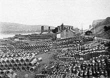
In 1900, 2,198 people lived in New Cumberland; in 1910, 1,807; and in 2000, 1,099. Local industry in the past involved the manufacture of fire and paving brick, sewer pipe, glassware, foundry and machine-shop products, and tiling. There were also coal mines and mills for the pulverization of fire clay for use in ironworks.
The First National Bank-Graham Building and Marshall House are listed on the National Register of Historic Places.[7]
Geography
New Cumberland is located at 40°29′57″N 80°36′29″W / 40.49917°N 80.60806°W (40.499146, -80.607960).[8]
According to the United States Census Bureau, the city has a total area of 1.86 square miles (4.82 km2), of which, 1.22 square miles (3.16 km2) is land and 0.64 square miles (1.66 km2) is water.[1] Due to the relative proximity of the Ohio River, New Cumberland has been the victim of several floods. Notable floods include 1959, where approximately 60 families were evacuated.[9]
Climate
This climatic region is typified by large seasonal temperature differences, with warm to hot (and often humid) summers and cold (sometimes severely cold) winters. According to the Köppen Climate Classification system, New Cumberland has a humid continental climate, abbreviated "Dfb" on climate maps.[10]
Demographics
| Historical population | |||
|---|---|---|---|
| Census | Pop. | %± | |
| 1880 | 1,218 | — | |
| 1890 | 2,305 | 89.2% | |
| 1900 | 2,198 | −4.6% | |
| 1910 | 1,807 | −17.8% | |
| 1920 | 1,816 | 0.5% | |
| 1930 | 2,300 | 26.7% | |
| 1940 | 2,098 | −8.8% | |
| 1950 | 2,119 | 1.0% | |
| 1960 | 2,076 | −2.0% | |
| 1970 | 1,865 | −10.2% | |
| 1980 | 1,752 | −6.1% | |
| 1990 | 1,363 | −22.2% | |
| 2000 | 1,099 | −19.4% | |
| 2010 | 1,103 | 0.4% | |
| Est. 2015 | 1,063 | [11] | −3.6% |
2010 census
As of the census[2] of 2010, there were 1,103 people, 526 households, and 289 families residing in the city. The population density was 904.1 inhabitants per square mile (349.1/km2). There were 583 housing units at an average density of 477.9 per square mile (184.5/km2). The racial makeup of the city was 97.6% White, 0.5% Asian, 0.4% from other races, and 1.5% from two or more races. Hispanic or Latino of any race were 1.4% of the population.
There were 526 households of which 21.5% had children under the age of 18 living with them, 38.6% were married couples living together, 11.8% had a female householder with no husband present, 4.6% had a male householder with no wife present, and 45.1% were non-families. 40.5% of all households were made up of individuals and 19.8% had someone living alone who was 65 years of age or older. The average household size was 2.10 and the average family size was 2.83.
The median age in the city was 47.3 years. 18.3% of residents were under the age of 18; 6.6% were between the ages of 18 and 24; 22% were from 25 to 44; 32.6% were from 45 to 64; and 20.5% were 65 years of age or older. The gender makeup of the city was 46.7% male and 53.3% female.
2000 census
As of the census[4] of 2000, there were 1,099 people, 513 households, and 286 families residing in the city. The population density was 897.6 people per square mile (347.8/km²). There were 568 housing units at an average density of 463.9 per square mile (179.8/km²). The racial makeup of the city was 99.27% White, 0.27% Asian, 0.09% from other races, and 0.36% from two or more races. Hispanic or Latino of any race were 1.09% of the population.
There were 513 households out of which 20.9% had children under the age of 18 living with them, 44.6% were married couples living together, 7.8% had a female householder with no husband present, and 44.1% were non-families. 39.2% of all households were made up of individuals and 22.4% had someone living alone who was 65 years of age or older. The average household size was 2.12 and the average family size was 2.85.
In the city the population was spread out with 19.1% under the age of 18, 6.1% from 18 to 24, 27.2% from 25 to 44, 26.6% from 45 to 64, and 21.0% who were 65 years of age or older. The median age was 43 years. For every 100 females there were 84.1 males. For every 100 females age 18 and over, there were 79.2 males.
The median income for a household in the city was $28,529, and the median income for a family was $37,589. Males had a median income of $30,625 versus $20,536 for females. The per capita income for the city was $18,109. About 6.2% of families and 9.5% of the population were below the poverty line, including 12.9% of those under age 18 and 7.5% of those age 65 or over.
Notable people
- John Bahnsen - United States Army Brigadier General and decorated veteran of the Vietnam War
- Daniel Johnston - singer-songwriter, musician, and artist
See also
References
- 1 2 "US Gazetteer files 2010". United States Census Bureau. Retrieved 2013-01-24.
- 1 2 "American FactFinder". United States Census Bureau. Retrieved 2013-01-24.
- ↑ "Population Estimates". United States Census Bureau. Retrieved 2013-06-26.
- 1 2 "American FactFinder". United States Census Bureau. Retrieved 2008-01-31.
- ↑ "US Board on Geographic Names". United States Geological Survey. 2007-10-25. Retrieved 2008-01-31.
- ↑ "Find a County". National Association of Counties. Retrieved 2011-06-07.
- ↑ National Park Service (2009-03-13). "National Register Information System". National Register of Historic Places. National Park Service.
- ↑ "US Gazetteer files: 2010, 2000, and 1990". United States Census Bureau. 2011-02-12. Retrieved 2011-04-23.
- ↑ http://www.laurelhollowpark.net/elo/newcumberlandwv-p2.html
- ↑ Climate Summary for New Cumberland, West Virginia
- ↑ "Annual Estimates of the Resident Population for Incorporated Places: April 1, 2010 to July 1, 2015". Retrieved July 2, 2016.
- ↑ "Census of Population and Housing". Census.gov. Retrieved June 4, 2015.
Municipalities and communities of Hancock County, West Virginia, United States | ||
|---|---|---|
| Cities | 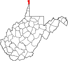 | |
| CDP | ||
| Unincorporated communities | ||
| Footnotes | ‡This populated place also has portions in an adjacent county or counties | |