Triadelphia, West Virginia
| Triadelphia, West Virginia | |
|---|---|
| Town | |
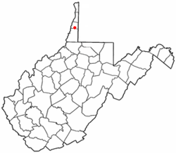 Location of Triadelphia, West Virginia | |
| Coordinates: 40°3′3″N 80°37′37″W / 40.05083°N 80.62694°WCoordinates: 40°3′3″N 80°37′37″W / 40.05083°N 80.62694°W | |
| Country | United States |
| State | West Virginia |
| County | Ohio |
| Area[1] | |
| • Total | 0.67 sq mi (1.74 km2) |
| • Land | 0.67 sq mi (1.74 km2) |
| • Water | 0 sq mi (0 km2) |
| Elevation | 741 ft (226 m) |
| Population (2010)[2] | |
| • Total | 811 |
| • Estimate (2012[3]) | 797 |
| • Density | 1,210.4/sq mi (467.3/km2) |
| Time zone | Eastern (EST) (UTC-5) |
| • Summer (DST) | EDT (UTC-4) |
| ZIP code | 26059 |
| Area code(s) | 304 |
| FIPS code | 54-80932[4] |
| GNIS feature ID | 1555822[5] |
Triadelphia is a town in Ohio County, West Virginia, United States. It is part of the Wheeling, West Virginia Metropolitan Statistical Area. The population was 811 at the 2010 census.
Triadelphia was originally chartered in 1829. The name Triadelphia was adopted from the Greek word meaning three brothers,[6] and most likely was named in honor of the three sons of the original owner of the town site.[7]
It is home to the Highlands, the largest retail complex in the Northern Panhandle of West Virginia.
Located near Tridelphia is the David Stewart Farm, listed on the National Register of Historic Places in 1979.[8]
Geography
Triadelphia is located at 40°3′3″N 80°37′37″W / 40.05083°N 80.62694°W (40.050705, -80.627015),[9] along Little Wheeling Creek and Middle Wheeling Creek, which are tributaries of Wheeling Creek.[10]
In West Virginia, U.S. Route 40 (US 40) runs through the northeastern suburbs of Wheeling, Triadelphia and Valley Grove. A majority of the route, including the portion in Triadelphia, still follows the route of the old National Road which predates the U.S. Highway System.
According to the United States Census Bureau, the town has a total area of 0.67 square miles (1.74 km2), all of it land.[1]
Demographics
| Historical population | |||
|---|---|---|---|
| Census | Pop. | %± | |
| 1850 | 242 | — | |
| 1860 | 258 | 6.6% | |
| 1870 | 239 | −7.4% | |
| 1880 | 313 | 31.0% | |
| 1890 | 515 | 64.5% | |
| 1900 | 287 | −44.3% | |
| 1910 | 261 | −9.1% | |
| 1920 | 299 | 14.6% | |
| 1930 | 302 | 1.0% | |
| 1940 | 359 | 18.9% | |
| 1950 | 741 | 106.4% | |
| 1960 | 600 | −19.0% | |
| 1970 | 547 | −8.8% | |
| 1980 | 1,461 | 167.1% | |
| 1990 | 835 | −42.8% | |
| 2000 | 817 | −2.2% | |
| 2010 | 811 | −0.7% | |
| Est. 2015 | 772 | [11] | −4.8% |
2010 census
As of the census[2] of 2010, there were 811 people, 373 households, and 221 families residing in the town. The population density was 1,210.4 inhabitants per square mile (467.3/km2). There were 402 housing units at an average density of 600.0 per square mile (231.7/km2). The racial makeup of the town was 95.1% White, 3.1% African American, 0.1% Asian, 0.1% from other races, and 1.6% from two or more races. Hispanic or Latino of any race were 1.0% of the population.
There were 373 households of which 26.0% had children under the age of 18 living with them, 36.5% were married couples living together, 15.5% had a female householder with no husband present, 7.2% had a male householder with no wife present, and 40.8% were non-families. 34.0% of all households were made up of individuals and 8.8% had someone living alone who was 65 years of age or older. The average household size was 2.17 and the average family size was 2.71.
The median age in the town was 40 years. 22.2% of residents were under the age of 18; 6.8% were between the ages of 18 and 24; 26.7% were from 25 to 44; 29.1% were from 45 to 64; and 15.3% were 65 years of age or older. The gender makeup of the town was 48.8% male and 51.2% female.
2000 census
As of the census[4] of 2000, there were 817 people, 370 households, and 223 families residing in the town. The population density was 1,187.2 inhabitants per square mile (457.2/km²). There were 406 housing units at an average density of 590.0 per square mile (227.2/km²). The racial makeup of the town was 97.31% White, 1.59% African American, 0.12% Native American, and 0.98% from two or more races. Hispanic or Latino of any race were 0.73% of the population. 25.9% were of German, 13.4% Irish, 11.2% Italian, 9.3% Polish, 8.9% American and 7.0% English ancestry according to Census 2000.
There were 370 households out of which 24.6% had children under the age of 18 living with them, 44.9% were married couples living together, 11.1% had a female householder with no husband present, and 39.7% were non-families. 35.1% of all households were made up of individuals and 14.3% had someone living alone who was 65 years of age or older. The average household size was 2.21 and the average family size was 2.83.
In the town the population was spread out with 20.8% under the age of 18, 9.8% from 18 to 24, 29.7% from 25 to 44, 25.9% from 45 to 64, and 13.7% who were 65 years of age or older. The median age was 39 years. For every 100 females there were 97.8 males. For every 100 females age 18 and over, there were 89.2 males.
The median income for a household in the town was $26,169, and the median income for a family was $36,136. Males had a median income of $25,441 versus $18,958 for females. The per capita income for the town was $14,267. About 15.8% of families and 15.8% of the population were below the poverty line, including 22.4% of those under age 18 and 6.0% of those age 65 or over.
References
- 1 2 "US Gazetteer files 2010". United States Census Bureau. Retrieved 2013-01-24.
- 1 2 "American FactFinder". United States Census Bureau. Retrieved 2013-01-24.
- ↑ "Population Estimates". United States Census Bureau. Retrieved 2013-06-26.
- 1 2 "American FactFinder". United States Census Bureau. Retrieved 2008-01-31.
- ↑ "US Board on Geographic Names". United States Geological Survey. 2007-10-25. Retrieved 2008-01-31.
- ↑ Capace, Nancy (1999). Encyclopedia of West Virginia. North American Book Dist LLC. p. 194. ISBN 978-0-403-09843-9.
- ↑ Kenny, Hamill (1945). West Virginia Place Names: Their Origin and Meaning, Including the Nomenclature of the Streams and Mountains. Piedmont, WV: The Place Name Press. p. 631.
- ↑ National Park Service (2010-07-09). "National Register Information System". National Register of Historic Places. National Park Service.
- ↑ "US Gazetteer files: 2010, 2000, and 1990". United States Census Bureau. 2011-02-12. Retrieved 2011-04-23.
- ↑ West Virginia Atlas & Gazetteer. Yarmouth, Me.: DeLorme. 1997. p. 21. ISBN 0-89933-246-3.
- ↑ "Annual Estimates of the Resident Population for Incorporated Places: April 1, 2010 to July 1, 2015". Retrieved July 2, 2016.
- ↑ "Census of Population and Housing". Census.gov. Retrieved June 4, 2015.
Municipalities and communities of Ohio County, West Virginia, United States | ||
|---|---|---|
| City | 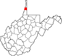 | |
| Towns | ||
| Villages | ||
| Unincorporated communities | ||
| Ghost town | ||
| Footnotes | ‡This populated place also has portions in an adjacent county or counties | |