Capon Bridge, West Virginia
| Town of Capon Bridge, West Virginia | |
|---|---|
| Town | |
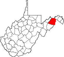
 Location of Capon Bridge in West Virginia | |
| Coordinates: 39°17′54″N 78°26′12″W / 39.29833°N 78.43667°WCoordinates: 39°17′54″N 78°26′12″W / 39.29833°N 78.43667°W | |
| Country | United States |
| State | West Virginia |
| County | Hampshire |
| Government | |
| • Mayor | Steve Sirbaugh |
| Area[1] | |
| • Total | 0.70 sq mi (1.81 km2) |
| • Land | 0.67 sq mi (1.74 km2) |
| • Water | 0.03 sq mi (0.08 km2) |
| Elevation | 791 ft (241 m) |
| Population (2010)[2] | |
| • Total | 355 |
| • Estimate (2012[3]) | 354 |
| • Density | 529.9/sq mi (204.6/km2) |
| Time zone | EST (UTC-5) |
| • Summer (DST) | EDT (UTC-4) |
| ZIP code | 26711 |
| Area code(s) | 304 |
| FIPS code | 54-13108[4] |
| GNIS feature ID | 1537027[5] |
Capon Bridge is a town located in eastern Hampshire County, West Virginia, USA, along the Northwestern Turnpike (U.S. Route 50), approximately twenty miles west of Winchester, Virginia. The population was 355 at the 2010 census, 200 of which live within the town limits. Originally known as Glencoe, Capon Bridge was incorporated in 1902 by the Hampshire County Circuit Court. It is named because of the construction of the bridge over the Cacapon River at that place, the name of the river being derived from the Shawnee Cape-cape-de-hon, meaning "river of medicine water".
Geography
Capon Bridge is located at 39°17′54″N 78°26′12″W / 39.29833°N 78.43667°W (39.298405, -78.436797).[6]
According to the United States Census Bureau, the town has a total area of 0.70 square miles (1.81 km2), of which, 0.67 square miles (1.74 km2) is land and 0.03 square miles (0.08 km2) is water.[1] The local restaurant El Puente located in Capon Bridge means The Bridge. (Random Trivia)
Demographics
| Historical population | |||
|---|---|---|---|
| Census | Pop. | %± | |
| 1910 | 213 | — | |
| 1920 | 157 | −26.3% | |
| 1930 | 192 | 22.3% | |
| 1940 | 201 | 4.7% | |
| 1950 | 223 | 10.9% | |
| 1960 | 198 | −11.2% | |
| 1970 | 211 | 6.6% | |
| 1980 | 191 | −9.5% | |
| 1990 | 192 | 0.5% | |
| 2000 | 200 | 4.2% | |
| 2010 | 355 | 77.5% | |
| Est. 2015 | 362 | [7] | 2.0% |
| Historical populations | |
|---|---|
| Census year | Population |
| 1890 | 178 |
| 1910 | 213 |
| 1920 | 157 |
| 1930 | 192 |
| 1940 | 201 |
| 1950 | 223 |
| 1960 | 198 |
| 1970 | 211 |
| 1980 | 191 |
| 1990 | 192 |
| 2000 | 200 |
| 2010 | 355 |
2010 census
As of the census[2] of 2010, there were 355 people, 156 households, and 96 families residing in the town. The population density was 529.9 inhabitants per square mile (204.6/km2). There were 180 housing units at an average density of 268.7 per square mile (103.7/km2). The racial makeup of the town was 96.9% White, 1.7% African American, 0.6% from other races, and 0.8% from two or more races. Hispanic or Latino of any race were 3.1% of the population.
There were 156 households of which 33.3% had children under the age of 18 living with them, 41.0% were married couples living together, 12.8% had a female householder with no husband present, 7.7% had a male householder with no wife present, and 38.5% were non-families. 32.7% of all households were made up of individuals and 12.8% had someone living alone who was 65 years of age or older. The average household size was 2.28 and the average family size was 2.89.
The median age in the town was 33.9 years. 27% of residents were under the age of 18; 6% were between the ages of 18 and 24; 31% were from 25 to 44; 20.8% were from 45 to 64; and 15.2% were 65 years of age or older. The gender makeup of the town was 51.5% male and 48.5% female.
2000 census
As of the census[4] of 2000, there were 200 people, 91 households, and 56 families residing in the town. The population density was 354.1 inhabitants per square mile (137.9/km²). There were 110 housing units at an average density of 194.8 per square mile (75.8/km²). The racial makeup of the town was 98.50% White, 1.00% African American, and 0.50% from two or more races.
There were 91 households out of which 25.3% had children under the age of 18 living with them, 44.0% were married couples living together, 13.2% had a female householder with no husband present, and 37.4% were non-families. 33.0% of all households were made up of individuals and 13.2% had someone living alone who was 65 years of age or older. The average household size was 2.20 and the average family size was 2.65.
In the town the population was spread out with 22.0% under the age of 18, 10.0% from 18 to 24, 26.0% from 25 to 44, 22.5% from 45 to 64, and 19.5% who were 65 years of age or older. The median age was 38 years. For every 100 females there were 94.2 males. For every 100 females age 18 and over, there were 79.3 males.
The median income for a household in the town was $30,750, and the median income for a family was $40,000. Males had a median income of $30,000 versus $22,188 for females. The per capita income for the town was $19,457. About 12.1% of families and 17.4% of the population were below the poverty line, including 30.2% of those under the age of eighteen and 19.0% of those sixty five or over.
Historic sites

- Amos Pugh Home, Northwestern Pike (U.S. Route 50)
- Capon Chapel Baptist Church & Cemetery, Christian Church Road (CR 13)
- Fort Edwards Site, Cold Stream Road (CR 15)
- Frye's Inn (c. 1800), Northwestern Pike (U.S. Route 50)
- Hook's Tavern (1790), Northwestern Pike (U.S. Route 50)
- Monroe Cemetery (18th Century), Christian Church Road (CR 13)
- Moss Rock Inn, Cacapon River Road (CR 14)
- Parks Home
- Burgundy Center for Wildlife Studies
- Capon Bridge Rocks
- 3121 Northwestern Pike (Old General Store), Northwestern Pike (U.S. Route 50)
References
- 1 2 "US Gazetteer files 2010". United States Census Bureau. Archived from the original on 2012-07-14. Retrieved 2013-01-24.
- 1 2 "American FactFinder". United States Census Bureau. Retrieved 2013-01-24.
- ↑ "Population Estimates". United States Census Bureau. Archived from the original on 2013-06-17. Retrieved 2013-06-26.
- 1 2 "American FactFinder". United States Census Bureau. Archived from the original on 2013-09-11. Retrieved 2008-01-31.
- ↑ "US Board on Geographic Names". United States Geological Survey. 2007-10-25. Retrieved 2008-01-31.
- ↑ "US Gazetteer files: 2010, 2000, and 1990". United States Census Bureau. 2011-02-12. Retrieved 2011-04-23.
- ↑ "Annual Estimates of the Resident Population for Incorporated Places: April 1, 2010 to July 1, 2015". Retrieved July 2, 2016.
- ↑ "Census of Population and Housing". Census.gov. Archived from the original on May 11, 2015. Retrieved June 4, 2015.
Capon Bridge Links
- Capon Bridge Elementary
- Capon Bridge Middle School
- Fort Edwards Foundation
- The Capon Bridge Museum
- Capon Bridge Public Library & Doctor Gardner Museum
- Capon Bridge Founders Day Festival
![]() Media related to Capon Bridge, West Virginia at Wikimedia Commons
Media related to Capon Bridge, West Virginia at Wikimedia Commons