Olive Hill, Kentucky
| Olive Hill, Kentucky | |
|---|---|
| City | |
|
Railroad Street | |
| Motto: "A nice place to call home" | |
 Location of Olive Hill, Kentucky | |
| Coordinates: 38°18′4″N 83°10′27″W / 38.30111°N 83.17417°WCoordinates: 38°18′4″N 83°10′27″W / 38.30111°N 83.17417°W | |
| Country | United States |
| State | Kentucky |
| County | Carter |
| Incorporated | March 24, 1884[1] |
| Government | |
| • Type | Mayor-Council |
| • Mayor | Kenny Fankell |
| Area | |
| • Total | 1.82 sq mi (4.72 km2) |
| • Land | 1.80 sq mi (4.65 km2) |
| • Water | 0.03 sq mi (0.07 km2) |
| Elevation | 748 ft (228 m) |
| Population (2010) | |
| • Total | 1,599 |
| • Density | 891/sq mi (344.2/km2) |
| Time zone | Eastern (EST) (UTC-5) |
| • Summer (DST) | EDT (UTC-4) |
| ZIP code | 41164 |
| Area code(s) | 606 |
| FIPS code | 21-57918 |
| GNIS feature ID | 0499923 |
| Website |
olivehill |

Olive Hill is a home rule-class city[2] along Tygarts Creek in Carter County, Kentucky, in the United States. The population was 1,599 during the year 2010 U.S. Census.[3]
History
Olive Hill began as a rural trading post established by the Henderson brothers in the first part of the 19th century. Although Olive Hill was allegedly named by Elias P. Davis for his friend Thomas Oliver, there is no evidence to support this popular contention. In 1881, the town was moved from a hillside location to the current location in the Tygarts Creek valley, where the Elizabethtown, Lexington and Big Sandy Railroad had laid tracks. The hillside location become known as Old Olive Hill and now serves as the city's residential area. On March 24, 1884, Olive Hill incorporated as a city and served as the county seat of the short-lived Beckham County from February 9 to April 29, 1904.[4]
The Chesapeake and Ohio Railway served Olive Hill and many other places on the railroad's Lexington Subdivision (running from Ashland to Lexington). The C&O merged into the Chessie System, which CSX Transportation later bought out, and after that CSX pulled up the railroad in the mid 1980s. Olive Hill retained and restored a passenger depot as well as a caboose ("John Hop Brown" Memorial Park).[5] Olive Hill's racial history is not one that makes for pleasant reading. According to George C. Wright in his A History of Blacks in Kentucky, volume 2, "In the small community of Olive Hill in 1917, several hundred white laborers at the brick-making General Refractories Company threatened to strike unless recently employed blacks were dismissed. After first refusing to meet with the leaders of the disgruntled workers, the company managers acceded to their demand and fired all the black workers(p.14)." Perhaps this is one of the reasons the 2010 census shows only .17% percentage of African Americans residing in the city.
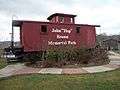 John "Hop" Brown Memorial park
 Preserved Passenger Depot
Geography
Olive Hill is located in western Carter County at 38°18′4″N 83°10′27″W / 38.30111°N 83.17417°W (38.301007, -83.174091),[6] primarily on the north side of Tygarts Creek, a tributary of the Ohio River. U.S. Route 60 passes through the city, leading east 14 miles (23 km) to Grayson, the Carter County seat, and west 18 miles (29 km) to Morehead. Interstate 64 passes 3 miles (5 km) north of Olive Hill, leading east 44 miles (71 km) to Huntington, West Virginia, and west 84 miles (135 km) to Lexington.
According to the United States Census Bureau, Olive Hill has a total area of 1.8 square miles (4.7 km2), of which 0.027 square miles (0.07 km2), or 1.51%, is water.[3]
Demographics
As of the census[7] of 2000, there were 1,813 people, 791 households, and 488 families residing in the city. The population density was 904.1 people per square mile (348.3/km²). There were 886 housing units at an average density of 441.8 per square mile (170.2/km²). The racial makeup of the city was 98.73% White, 0.17% African American, 0.50% Native American, 0.11% from other races, and 0.50% from two or more races. Hispanic or Latino of any race were 0.61% of the population.
| Historical population | |||
|---|---|---|---|
| Census | Pop. | %± | |
| 1880 | 56 | — | |
| 1890 | 186 | 232.1% | |
| 1900 | 291 | 56.5% | |
| 1910 | 1,182 | 306.2% | |
| 1920 | 1,395 | 18.0% | |
| 1930 | 1,484 | 6.4% | |
| 1940 | 1,491 | 0.5% | |
| 1950 | 1,351 | −9.4% | |
| 1960 | 1,398 | 3.5% | |
| 1970 | 1,197 | −14.4% | |
| 1980 | 2,539 | 112.1% | |
| 1990 | 1,809 | −28.8% | |
| 2000 | 1,813 | 0.2% | |
| 2010 | 1,599 | −11.8% | |
| Est. 2015 | 1,599 | [8] | 0.0% |
There were 791 households out of which 26.5% had children under the age of 18 living with them, 44.5% were married couples living together, 14.5% had a female householder with no husband present, and 38.2% were non-families. 34.8% of all households were made up of individuals and 18.6% had someone living alone who was 65 years of age or older. The average household size was 2.28 and the average family size was 2.93.
In the city the population was spread out with 24.5% under the age of 18, 8.3% from 18 to 24, 24.4% from 25 to 44, 24.4% from 45 to 64, and 18.4% who were 65 years of age or older. The median age was 39 years. For every 100 females there were 83.7 males. For every 100 females age 18 and over, there were 78.0 males.
The median income for a household in the city was $22,958, and the median income for a family was $31,071. Males had a median income of $24,063 versus $19,191 for females. The per capita income for the city was $12,628. About 16.7% of families and 24.8% of the population were below the poverty line, including 35.1% of those under age 18 and 23.5% of those age 65 or over.
Education
Carter County School District:
- Olive Hill Elementary School
- West Carter Middle School
- West Carter High School
Notable people
Olive Hill is the birthplace of country music singer Tom T. Hall, a fact that is noted on the "Welcome to Olive Hill" signs on the edges of town.
See also
- Other places named Olive Hill
References
- ↑ Commonwealth of Kentucky. Office of the Secretary of State. Land Office. "Olive Hill, Kentucky". Accessed 18 September 2013.
- ↑ "Summary and Reference Guide to House Bill 331 City Classification Reform" (PDF). Kentucky League of Cities. Retrieved December 30, 2014.
- 1 2 "Geographic Identifiers: 2010 Demographic Profile Data (G001): Olive Hill city, Kentucky". U.S. Census Bureau, American Factfinder. Retrieved August 11, 2014.
- ↑ Rennick, Robert M. (1988). "Place Names". Kentucky Place Names. Lexington, Kentucky: The University Press of Kentucky. ISBN 0-8131-0179-4. Retrieved on 2010-11-05
- ↑ http://www.olivehill.ky.gov/NR/rdonlyres/2CB4FB65-428B-4452-B5BB-13EF4FF8928A/0/OliveHillLongTermRecoveryPlan.pdf
- ↑ "US Gazetteer files: 2010, 2000, and 1990". United States Census Bureau. 2011-02-12. Retrieved 2011-04-23.
- ↑ "American FactFinder". United States Census Bureau. Retrieved 2008-01-31.
- ↑ "Annual Estimates of the Resident Population for Incorporated Places: April 1, 2010 to July 1, 2015". Retrieved July 2, 2016.
- ↑ "Census of Population and Housing". Census.gov. Retrieved June 4, 2015.
External links
Municipalities and communities of Carter County, Kentucky, United States | ||
|---|---|---|
| Cities | 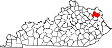 | |
| Unincorporated communities | ||
| Footnotes | ‡This populated place also has portions in an adjacent county or counties | |
| Principal cities |  | |
|---|---|---|
| Municipalities with population over 5,000 | ||
| Municipalities with population 1,000–5,000 | ||
| Municipalities with population under 1,000 | ||
| West Virginia counties | ||
| Kentucky counties | ||
| Ohio counties | ||
