Huntington, West Virginia metropolitan area
Coordinates: 38°25′09″N 82°26′43″W / 38.41917°N 82.44528°W
| Greater Huntington | |
|---|---|
| Huntington-Ashland, WV-KY-OH MSA | |
 | |
| Coordinates: 38°25′09″N 82°26′43″W / 38.4192°N 82.4453°W | |
| Country | United States |
| State(s) | West Virginia, Kentucky, Ohio |
| Largest city | Huntington |
| Other cities |
- Ashland - Ironton - Teays Valley - Flatwoods |
| Area | |
| • Total | 2,159.9 sq mi (5,594 km2) |
| Highest elevation | Kelly Knob[1] 1,512 ft (461 m) |
| Lowest elevation | Ohio River[2] 485 ft (148 m) |
| Population (2015 est.) | |
| • Total | 361,580 |
| • Rank | 146th in the U.S. |
| • Density | 167.4/sq mi (64.6/km2) |
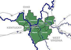
The Huntington-Ashland metropolitan area is the largest MSA in West Virginia. The United States metropolitan area includes seven counties across three states: West Virginia, Kentucky, and Ohio. New definitions from February 28, 2013 placed the population at 361,580.[3] The MSA is nestled along the banks of the Ohio River within the Appalachian Plateau region. The area is most often referred to locally as the Tri-State region. Sometimes it is also referred to by the acronym KYOVA (KentuckY, Ohio, West VirginiA). In addition, the three largest cities (Huntington, West Virginia; Ashland, Kentucky; and Ironton, Ohio) are referred to locally as the River Cities.
Counties
| County | State | Population (2011) | Seat |
|---|---|---|---|
| Boyd | Kentucky | 49,466 | Catlettsburg |
| Cabell | West Virginia | 96,653 | Huntington |
| Carter | Kentucky | 27,586 | Grayson |
| Greenup | Kentucky | 36,865 | Greenup |
| Lawrence | Ohio | 62,489 | Ironton |
| Lincoln | West Virginia | 22,147 | Hamlin |
| Putnam | West Virginia | 55,673 | Winfield |
| Wayne | West Virginia | 42,126 | Wayne |
Communities


Largest cities (more than 5,000 inhabitants)
| City | Population (2011 est.) [4][5][6] |
Note |
|---|---|---|
| Huntington, West Virginia | 49,253 | Principal city of the MSA[7] |
| Ashland, Kentucky | 21,652 (2011)[8] |
Principal city of the MSA[7] |
| Teays Valley, West Virginia | 13,175 | Census-designated place (population as of 2010 census) |
| Ironton, Ohio | 11,135 | Incorporated city |
| Flatwoods, Kentucky | 7,412 | Incorporated city |
| Nitro, West Virginia (partial) | 7,178 | Incorporated city |
| Pea Ridge, West Virginia | 6,650 | Census-designated place (population as of 2010 census) |
| Hurricane, West Virginia | 6,284 | Incorporated city |
Places with 1,000 to 5,000 inhabitants
|
|
Places with fewer than 1,000 inhabitants
- Athalia, Ohio
- Bancroft, West Virginia
- Bellefonte, Kentucky
- Chesapeake, Ohio
- Fort Gay, West Virginia
- Hanging Rock, Ohio
- Lavalette, West Virginia (census-designated place)
- Poca, West Virginia
- Proctorville, Ohio
- West Hamlin, West Virginia
Unincorporated places
Townships (Lawrence County, Ohio)
Demographics
As of the census[9] of 2000, there were 288,649 people, 117,697 households, and 81,089 families residing within the MSA (New definitions from February 28, 2013 placed the population at 363,000).[3] The racial makeup of the MSA was 95.91% White, 2.42% African American, 0.18% Native American, 0.43% Asian, 0.02% Pacific Islander, 0.15% from other races, and 0.89% from two or more races. Hispanic or Latino of any race were 0.68% of the population.
The median income for a household in the MSA was $29,970, and the median income for a family was $37,102. Males had a median income of $33,032 versus $21,543 for females. The per capita income for the MSA was $16,514.
In 2008, an Associated Press article designated the Huntington-Ashland metropolitan area as the unhealthiest in America, based on its analysis of data collected in 2006 by the Centers for Disease Control and Prevention. Nearly half the adults in this metropolitan area were obese.[10]
Major highways

 Interstate 64
 U.S. Route 60
 U.S. Route 23
 U.S. Route 52
 West Virginia Route 2
 West Virginia Route 10
 West Virginia Route 152
 West Virginia Route 527
 Kentucky Route 3
 John Y. Brown Jr. AA Highway (KY 10)
 Industrial Parkway (KY 67)
 Kentucky Route 180
 Ohio State Route 7
 Ohio State Route 93
 Ohio Route 527
Area codes
The following prefixes are used for long-distance phone service dialing to the region within the MSA.
- 304, 681 – West Virginia Counties
- 606 – Kentucky Counties
- 740 – Ohio
Higher education
- Ashland Community and Technical College
- Collins Career Center
- Huntington Junior College
- Marshall University
- Morehead State University at Ashland
- Mountwest Community and Technical College
- Ohio University Southern Campus
See also
- Kentucky census statistical areas
- Ohio census statistical areas
- West Virginia census statistical areas
References
- ↑ "Kelly Knob". Geographic Names Information System. United States Geological Survey. Retrieved on 2010-08-19
- ↑ Groundwater Resources of Greenup County, Kentucky Retrieved on 2010-08-19
- 1 2 "Population statistics" (PDF).
- ↑ "Annual Estimates of the Population for Incorporated Places in Kentucky". U.S. Census Bureau. Retrieved 2012-08-04.
- ↑ "Annual Estimates of the Population for Incorporated Places in Ohio". U.S. Census Bureau. Retrieved 2009-01-27.
- ↑ "Annual Estimates of the Population for Incorporated Places in West Virginia". U.S. Census Bureau. Retrieved 2009-01-27.
- 1 2 "Metropolitan and micropolitan statistical areas". U.S. Census Bureau, Population Division. 2012-08-04. Retrieved 2012-08-04.
- ↑ "2011Demographic Profile Data: Ashland, Kentucky". American FactFinder. United States Census Bureau. Retrieved August 4, 2012.
- ↑ "American FactFinder". United States Census Bureau. Archived from the original on September 11, 2013. Retrieved 2008-01-31.
- ↑ http://www.herald-dispatch.com/news/briefs/x2114471550/Huntington-area-labeled-as-nation-s-most-unhealthy