Follansbee, West Virginia
| Follansbee, West Virginia | |
|---|---|
| City | |
| Nickname(s): City of Pride, Yokie | |
| Motto: Follansbee Never Fails | |
 Location of Follansbee, West Virginia | |
| Coordinates: 40°19′59″N 80°35′39″W / 40.33306°N 80.59417°WCoordinates: 40°19′59″N 80°35′39″W / 40.33306°N 80.59417°W | |
| Country | United States |
| State | West Virginia |
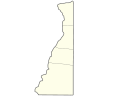
| County | Brooke |
| Government | |
| • Mayor | David Velegol |
| • City Manager | John DeStefano |
| Area[1] | |
| • Total | 2.09 sq mi (5.41 km2) |
| • Land | 1.84 sq mi (4.77 km2) |
| • Water | 0.25 sq mi (0.65 km2) |
| Elevation | 669 ft (204 m) |
| Population (2010)[2] | |
| • Total | 2,986 |
| • Estimate (2012[3]) | 2,956 |
| • Density | 1,622.8/sq mi (626.6/km2) |
| Time zone | Eastern (EST) (UTC-5) |
| • Summer (DST) | EDT (UTC-4) |
| ZIP code | 26037 |
| Area code | 304 |
| FIPS code | 54-28204[4] |
| GNIS feature ID | 1554480[5] |
| Website | http://www.cityoffollansbee.net |
Follansbee is a city in Brooke County, West Virginia, United States, located along the Ohio River. It is part of the Weirton-Steubenville, WV-OH Metropolitan Statistical Area. The population was 2,986 at the 2010 census.
The city was named after the Follansbee brothers, the proprietors of a local steel mill.[6]
Geography
Follansbee is located at 40°19′59″N 80°35′39″W / 40.33306°N 80.59417°W (40.332919, -80.594048).[7]
According to the United States Census Bureau, the city has a total area of 2.09 square miles (5.41 km2), of which, 1.84 square miles (4.77 km2) is land and 0.25 square miles (0.65 km2) is water.[1]
Demographics
| Historical population | |||
|---|---|---|---|
| Census | Pop. | %± | |
| 1910 | 2,031 | — | |
| 1920 | 3,135 | 54.4% | |
| 1930 | 4,841 | 54.4% | |
| 1940 | 4,834 | −0.1% | |
| 1950 | 4,435 | −8.3% | |
| 1960 | 4,052 | −8.6% | |
| 1970 | 3,883 | −4.2% | |
| 1980 | 3,994 | 2.9% | |
| 1990 | 3,339 | −16.4% | |
| 2000 | 3,115 | −6.7% | |
| 2010 | 2,986 | −4.1% | |
| Est. 2015 | 2,887 | [8] | −3.3% |
2010 census
As of the census[2] of 2010, there were 2,986 people, 1,302 households, and 842 families residing in the city. The population density was 1,622.8 inhabitants per square mile (626.6/km2). There were 1,432 housing units at an average density of 778.3 per square mile (300.5/km2). The racial makeup of the city was 97.6% White, 0.3% African American, 0.1% Native American, 0.2% Asian, 0.2% from other races, and 1.5% from two or more races. Hispanic or Latino of any race were 0.7% of the population.
There were 1,302 households of which 27.0% had children under the age of 18 living with them, 46.1% were married couples living together, 13.1% had a female householder with no husband present, 5.5% had a male householder with no wife present, and 35.3% were non-families. 30.6% of all households were made up of individuals and 14.1% had someone living alone who was 65 years of age or older. The average household size was 2.29 and the average family size was 2.85.
The median age in the city was 44.6 years. 20.7% of residents were under the age of 18; 7.7% were between the ages of 18 and 24; 22.1% were from 25 to 44; 30.9% were from 45 to 64; and 18.7% were 65 years of age or older. The gender makeup of the city was 47.4% male and 52.6% female.
2000 census
As of the census[4] of 2000, there were 3,115 people, 1,340 households, and 911 families residing in the city. The population density was 1,757.9 people per square mile (679.5/km²). There were 1,453 housing units at an average density of 820.0 per square mile (317.0/km²). The racial makeup of the city was 98.97% White, 0.06% African American, 0.06% Native American, 0.32% Asian, 0.03% from other races, and 0.55% from two or more races. Hispanic or Latino of any race were 0.26% of the population.
There were 1,340 households out of which 26.4% had children under the age of 18 living with them, 50.6% were married couples living together, 13.0% had a female householder with no husband present, and 32.0% were non-families. 29.2% of all households were made up of individuals and 16.3% had someone living alone who was 65 years of age or older. The average household size was 2.32 and the average family size was 2.86.
In the city the age distribution of the population shows 21.3% under the age of 18, 7.4% from 18 to 24, 24.8% from 25 to 44, 26.2% from 45 to 64, and 20.4% who were 65 years of age or older. The median age was 43 years. For every 100 females there were 90.1 males. For every 100 females age 18 and over, there were 88.0 males.
The median income for a household in the city was $30,818, and the median income for a family was $37,679. Males had a median income of $36,063 versus $19,554 for females. The per capita income for the city was $16,824. About 11.6% of families and 12.8% of the population were below the poverty line, including 21.4% of those under age 18 and 8.2% of those age 65 or over.
See also
Notable residents
- Lou Holtz, former NCAA and NFL football coach (born in Follansbee)
- Glenn Davis, Olympic hurdler and sprinter who won a total of three gold medals in the 1956 and 1960 Olympic Games (born in Follansbee)
- Anthony di Bonaventura, U.S. concert pianist and pedagogue
References
- 1 2 "US Gazetteer files 2010". United States Census Bureau. Retrieved 2013-01-24.
- 1 2 "American FactFinder". United States Census Bureau. Retrieved 2013-01-24.
- ↑ "Population Estimates". United States Census Bureau. Retrieved 2013-06-26.
- 1 2 "American FactFinder". United States Census Bureau. Retrieved 2008-01-31.
- ↑ "US Board on Geographic Names". United States Geological Survey. 2007-10-25. Retrieved 2008-01-31.
- ↑ Kenny, Hamill (1945). West Virginia Place Names: Their Origin and Meaning, Including the Nomenclature of the Streams and Mountains. Piedmont, WV: The Place Name Press. p. 245.
- ↑ "US Gazetteer files: 2010, 2000, and 1990". United States Census Bureau. 2011-02-12. Retrieved 2011-04-23.
- ↑ "Annual Estimates of the Resident Population for Incorporated Places: April 1, 2010 to July 1, 2015". Retrieved July 2, 2016.
- ↑ "Census of Population and Housing". Census.gov. Retrieved June 4, 2015.
External links
Municipalities and communities of Brooke County, West Virginia, United States | ||
|---|---|---|
| Cities | 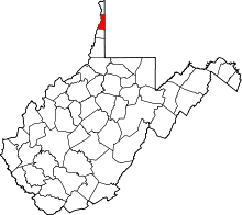 | |
| Town | ||
| Villages | ||
| CDP | ||
| Unincorporated communities | ||
| Footnotes | ‡This populated place also has portions in an adjacent county or counties | |