Lesage, West Virginia
| Lesage, West Virginia | |
|---|---|
| Census-designated place (CDP) | |
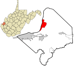 Location in Cabell County and the state of West Virginia. | |
| Coordinates: 38°30′23″N 82°17′55″W / 38.50639°N 82.29861°WCoordinates: 38°30′23″N 82°17′55″W / 38.50639°N 82.29861°W | |
| Country | United States |
| State | West Virginia |
| County | Cabell |
| Area[1] | |
| • Total | 7.234 sq mi (18.74 km2) |
| • Land | 6.095 sq mi (15.79 km2) |
| • Water | 1.139 sq mi (2.95 km2) |
| Population (2010)[2] | |
| • Total | 1,358 |
| • Density | 190/sq mi (72/km2) |
| Time zone | Eastern (EST) (UTC-5) |
| • Summer (DST) | EDT (UTC-4) |
Lesage is a census-designated place (CDP) on Ohio River Road in Cabell County, West Virginia, USA. As of the 2010 census, its population was 1,358.[2] It is the nearest community to Clover Site, a National Historic Landmark.
Lesage is a part of the Huntington-Ashland Metropolitan Statistical Area (MSA). As of the 2010 census, the MSA had a population of 287,702. New definitions from February 28, 2013 placed the population at 363,000.[3]
The community was named after Jules F. M. LeSage, an early settler.[4]
References
- ↑ "US Gazetteer files: 2010, 2000, and 1990". United States Census Bureau. 2011-02-12. Retrieved 2011-04-23.
- 1 2 "American FactFinder". United States Census Bureau. Archived from the original on September 11, 2013. Retrieved 2011-05-14.
- ↑ "Population statistics" (PDF).
- ↑ Kenny, Hamill (1945). West Virginia Place Names: Their Origin and Meaning, Including the Nomenclature of the Streams and Mountains. Piedmont, WV: The Place Name Press. p. 368-369.
Municipalities and communities of Cabell County, West Virginia, United States | ||
|---|---|---|
| City | 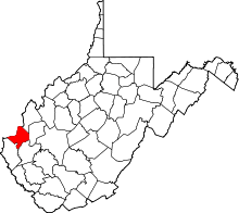 | |
| Town | ||
| Village | ||
| CDPs | ||
| Other communities | ||
| Footnotes | ‡This populated place also has portions in an adjacent county or counties | |
| Principal cities | 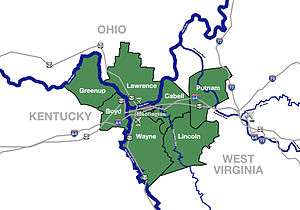 | |
|---|---|---|
| Municipalities with population over 5,000 | ||
| Municipalities with population 1,000–5,000 | ||
| Municipalities with population under 1,000 | ||
| West Virginia counties | ||
| Kentucky counties | ||
| Ohio counties | ||
This article is issued from Wikipedia - version of the 7/20/2016. The text is available under the Creative Commons Attribution/Share Alike but additional terms may apply for the media files.