Pineville, West Virginia
| Pineville, West Virginia | |
|---|---|
| Town | |
|
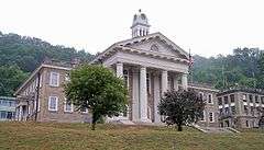
Main Street (West Virginia Route 97) in Pineville in 2007 | |
 Location of Pineville, West Virginia | |
| Coordinates: 37°34′59″N 81°32′7″W / 37.58306°N 81.53528°WCoordinates: 37°34′59″N 81°32′7″W / 37.58306°N 81.53528°W | |
| Country | United States |
| State | West Virginia |
| County | Wyoming |
| Area[1] | |
| • Total | 0.84 sq mi (2.18 km2) |
| • Land | 0.80 sq mi (2.07 km2) |
| • Water | 0.04 sq mi (0.10 km2) |
| Elevation | 1,299 ft (396 m) |
| Population (2010)[2] | |
| • Total | 668 |
| • Estimate (2012[3]) | 654 |
| • Density | 835.0/sq mi (322.4/km2) |
| Time zone | Eastern (EST) (UTC-5) |
| • Summer (DST) | EDT (UTC-4) |
| ZIP codes | 24859, 24874 |
| Area code(s) | 304 |
| FIPS code | 54-63940[4] |
| GNIS feature ID | 1544914[5] |

Pineville is a town in Wyoming County, West Virginia, USA, situated along the Guyandotte River. The population was 668 at the 2010 census. It is the county seat.[6]
History
Pineville was settled by William Short in 1853.
In 1863, Hiram Clay first settled near the site of present Pineville. The community was once called Castlerock, and the post office there was once named Rock Castle. The town was renamed Pineville for the local pine forest and incorporated as a town under that name in 1907.[7] It was named because it was built on the site of a black or pitch pine forest.[8]
Pineville became the county seat in 1907, replacing Oceana after a series of disputed elections. Castle Rock, the towering sandstone formation for which Rockcastle Creek is named, is located at Pineville and is the major local landmark. The Wyoming County Courthouse (1916) is on the National Register of Historic Places.[7]
Geography
Pineville is located at 37°34′59″N 81°32′7″W / 37.58306°N 81.53528°W (37.582925, −81.535302).[9] The Guyandotte River flows through Pineville, and collects its tributaries Rockcastle Creek and Pinnacle Creek within the town.[10]
According to the United States Census Bureau, the town has a total area of 0.84 square miles (2.18 km2), of which, 0.80 square miles (2.07 km2) is land and 0.04 square miles (0.10 km2) is water.[1]
Many subdivisions or outer areas are considered part of Pineville, including Key Rock, New Richmond, Skin Fork, Mullensville, Glover, Wolf Pen, Rock View, and others, but the town limits are much smaller than the area considered part of Pineville. Unique in the county school system, Pineville's secondary school had no feeder schools. Only after the county's population declined sharply in the 1990s did consolidation and closure of the Glen Rogers High School cause students who attended elementary school outside of Pineville to attend middle or high school in Pineville. Further consolidation ended the town's high school, which was consolidated with Mullens High School to form Wyoming East High School. Students from the catchement areas of the former Herndon, Glen Rogers, Mullens, and Pineville High Schools attend this high school.
Demographics
| Historical population | |||
|---|---|---|---|
| Census | Pop. | %± | |
| 1910 | 334 | — | |
| 1920 | 304 | −9.0% | |
| 1930 | 462 | 52.0% | |
| 1940 | 769 | 66.5% | |
| 1950 | 1,082 | 40.7% | |
| 1960 | 1,137 | 5.1% | |
| 1970 | 1,187 | 4.4% | |
| 1980 | 1,140 | −4.0% | |
| 1990 | 865 | −24.1% | |
| 2000 | 715 | −17.3% | |
| 2010 | 668 | −6.6% | |
| Est. 2015 | 628 | [11] | −6.0% |
2010 census
As of the census[2] of 2010, there were 668 people, 303 households, and 200 families residing in the town. The population density was 835.0 inhabitants per square mile (322.4/km2). There were 345 housing units at an average density of 431.3 per square mile (166.5/km2). The racial makeup of the town was 97.8% White, 0.4% African American, 0.4% Asian, and 1.3% from two or more races. Hispanic or Latino of any race were 0.3% of the population.
There were 303 households of which 24.1% had children under the age of 18 living with them, 50.8% were married couples living together, 10.2% had a female householder with no husband present, 5.0% had a male householder with no wife present, and 34.0% were non-families. 29.4% of all households were made up of individuals and 15.5% had someone living alone who was 65 years of age or older. The average household size was 2.20 and the average family size was 2.69.
The median age in the town was 49.4 years. 17.4% of residents were under the age of 18; 6.6% were between the ages of 18 and 24; 21% were from 25 to 44; 30.8% were from 45 to 64; and 24% were 65 years of age or older. The gender makeup of the town was 49.6% male and 50.4% female.
2000 census
As of the census[4] of 2000, there were 715 people, 334 households, and 219 families residing in the town. The population density was 908.7 inhabitants per square mile (349.4/km²). There were 377 housing units at an average density of 479.1 per square mile (184.3/km²). The racial makeup of the town was 98.74% White, 0.70% African American, 0.14% Native American, 0.28% Asian, and 0.14% from two or more races. Hispanic or Latino of any race were 0.14% of the population.
There were 334 households out of which 23.1% had children under the age of 18 living with them, 54.2% were married couples living together, 9.0% had a female householder with no husband present, and 34.4% were non-families. 32.0% of all households were made up of individuals and 16.8% had someone living alone who was 65 years of age or older. The average household size was 2.14 and the average family size was 2.64.
In the town the population was spread out with 17.9% under the age of 18, 7.1% from 18 to 24, 21.3% from 25 to 44, 29.8% from 45 to 64, and 23.9% who were 65 years of age or older. The median age was 47 years. For every 100 females there were 86.7 males. For every 100 females age 18 and over, there were 83.4 males.
The median income for a household in the town was $31,008, and the median income for a family was $45,000. Males had a median income of $39,688 versus $29,167 for females. The per capita income for the town was $25,184. About 5.2% of families and 10.0% of the population were below the poverty line, including 21.3% of those under age 18 and 7.1% of those age 65 or over.
Transportation
Highways
Notable people
- Judge Robert D. Bailey, Sr. (1883–1961) – was a Pineville resident
- Curt Warner – NFL running back in the 1980s for the Seattle Seahawks and then the Los Angeles Rams.
- Heath Miller – Professional wrestler competing in WWE as Heath Slater.
- Kenneth R. Shadrick, reported to be the first casualty of the Korean War.
References
- 1 2 "US Gazetteer files 2010". United States Census Bureau. Archived from the original on January 24, 2012. Retrieved 2013-01-24.
- 1 2 "American FactFinder". United States Census Bureau. Retrieved 2013-01-24.
- ↑ "Population Estimates". United States Census Bureau. Archived from the original on June 17, 2013. Retrieved 2013-06-26.
- 1 2 "American FactFinder". United States Census Bureau. Retrieved 2008-01-31.
- ↑ "US Board on Geographic Names". United States Geological Survey. 2007-10-25. Retrieved 2008-01-31.
- ↑ "Find a County". National Association of Counties. Archived from the original on May 31, 2011. Retrieved 2011-06-07.
- 1 2 unknown (October 22, 2010). "The West Virginia Encyclopedia: Pineville". West Virginia Humanities Council. Retrieved 2011-07-23.
- ↑ Kenny, Hamill (1945). West Virginia Place Names: Their Origin and Meaning, Including the Nomenclature of the Streams and Mountains. Piedmont, WV: The Place Name Press. p. 490.
- ↑ "US Gazetteer files: 2010, 2000, and 1990". United States Census Bureau. 2011-02-12. Retrieved 2011-04-23.
- ↑ West Virginia Atlas & Gazetteer. Yarmouth, Me.: DeLorme. 1997. p. 58. ISBN 0-89933-246-3.
- ↑ "Annual Estimates of the Resident Population for Incorporated Places: April 1, 2010 to July 1, 2015". Retrieved July 2, 2016.
- ↑ "Census of Population and Housing". Census.gov. Archived from the original on May 11, 2015. Retrieved June 4, 2015.
External links
Municipalities and communities of Wyoming County, West Virginia, United States | ||
|---|---|---|
| City | 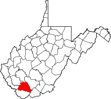 | |
| Towns | ||
| CDPs | ||
| Unincorporated communities |
| |
| Footnotes | ‡This populated place also has portions in an adjacent county or counties | |