Furnace Creek Inn and Ranch Resort
The Furnace Creek Inn and Ranch Resort is a privately owned luxury resort in Furnace Creek, on private land within the boundaries of California's Death Valley National Park. It is operated by Xanterra.
The Inn at Furnace Creek is a member of Historic Hotels of America, the official program of the National Trust for Historic Preservation.[1]
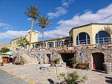
Furnace Creek Inn
The Furnace Creek Inn was originally constructed by the Pacific Coast Borax Company and opened on February 1, 1927, with twelve rooms. Richard C. Baker, then president of Pacific Coast Borax sought to open Death Valley to tourism in an effort to increase revenue on the Tonopah and Tidewater Railroad originally built by Francis Marion Smith for shipping borax, but in need of new sources of revenue. 20 additional rooms, as well as a swimming pool and tennis courts were added in the 1930s. The Fred Harvey Company operated the facilities for decades. The Desert Inn now has 66 rooms, located on the hillside, and is open from October through May.
Furnace Creek Ranch
The Furnace Creek Ranch (36°27′23″N 116°52′07″W / 36.45639°N 116.86861°W), a separate lodging facility from the Inn, is on the valley floor next to the Park's Visitor Center.
The ranch is known for being the location of the highest temperature recorded on Earth at 56.7 °C (134 °F) on July 10, 1913.[2]
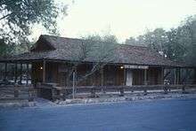
Borax Museum
The Borax Museum is located at the Furnace Creek Ranch. The museum features borax mining tools and equipment of the Pacific Coast Borax Company, models of Twenty-mule team wagon trains, pioneer artifacts and mineral specimens.
References
- ↑ "The Inn at Furnace Creek, a Historic Hotels of America member". Historic Hotels of America. Retrieved January 28, 2014.
- ↑ "World Weather/Climate Extremes Archive". Arizona State University. Retrieved 6 November 2012.
| Wikimedia Commons has media related to Furnace Creek Ranch. |
| Wikimedia Commons has media related to Borax Museum. |
External links
- Furnace Creek Resort
- Borax Museum
- "The Desert Queen: Death Valley National Park's Furnace Creek Inn", NationalParksTraveler.com
Coordinates: 36°27′02″N 116°51′08″W / 36.45056°N 116.85222°W