California State Route 127
| ||||
|---|---|---|---|---|
| Death Valley Road | ||||
|
Map of eastern California with SR 127 highlighted in red | ||||
| Route information | ||||
| Defined by Streets and Highways Code § 427 | ||||
| Maintained by Caltrans | ||||
| Length: | 91.033 mi[1] (146.503 km) | |||
| Major junctions | ||||
| South end: |
| |||
| North end: |
| |||
| Highway system | ||||
| ||||

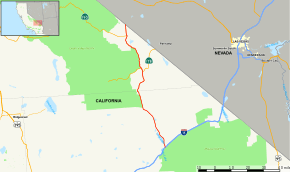
State Route 127 (SR 127) is a California state highway that connects Interstate 15 to Nevada State Route 373, passing near Death Valley National Park. The entire length of the highway closely follows the central portion of the former Tonopah and Tidewater Railroad and loosely follows the Amargosa River.
Route description
SR 127 is part of the California Freeway and Expressway System[2] and is eligible for the State Scenic Highway System.[3] However, it has not been designated by Caltrans as a scenic highway.[4]
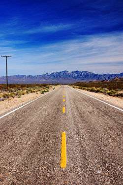
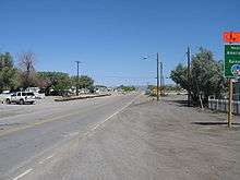
The highway begins at I-15 in the community of Baker, the last town travelers from the Greater Los Angeles area or the Las Vegas Valley see before making their trek across Death Valley. SR 127 travels through the town of Baker as Death Valley Road before turning slightly northwest and traveling along the edge of Silver Lake, a dry lake. The road parallels Salt Creek and Silurian Lake as it crosses the Valjean Valley. SR 127 soon runs along the southeastern edge of Death Valley National Park and cuts through the mountains as it is entering Inyo County.[5]
After passing by the turnoff for Tecopa Hot Springs, SR 127 runs concurrently with SR 178 through the community of Shoshone. SR 127 continues along the eastern edge of Death Valley National Park, passing by Eagle Mountain and the Amargosa River before intersecting SR 190 at Death Valley Junction. The road ends at the California-Nevada border, where Nevada State Route 373 begins.[6] It is the "Lost Highway" featured in David Lynch's film Lost Highway.
History
In 1933, Route 127 was added to the state highway system, and went from Baker to Death Valley Junction; Route 128 went from there to the Nevada state line.[7] In the 1964 state highway renumbering, SR 127 was defined from I-15 to the Nevada state line.[8] The route has remained the same since its definition.
Major intersections
Except where prefixed with a letter, postmiles were measured on the road as it was in 1964, based on the alignment that existed at the time, and do not necessarily reflect current mileage. R reflects a realignment in the route since then, M indicates a second realignment, L refers an overlap due to a correction or change, and T indicates postmiles classified as temporary (for a full list of prefixes, see the list of postmile definitions).[1] Segments that remain unconstructed or have been relinquished to local control may be omitted. The numbers reset at county lines; the start and end postmiles in each county are given in the county column.
| County | Location | Postmile [1][9][10] | Destinations | Notes | |
|---|---|---|---|---|---|
| San Bernardino SBD L0.00-41.47 | Baker | L0.00 | Kelbaker Road | Continuation beyond I-15 | |
| L0.00 | Interchange; south end of SR 127; I-15 exit 246 | ||||
| 0.00 | Baker Boulevard (I-15 Bus.) – Las Vegas, Barstow | Former US 91 / US 466 | |||
| Inyo INY 0.00-49.42 | | 6.51 | Old Spanish Trail Highway – Tecopa, Hot Springs | ||
| Shoshone | 14.75 | South end of SR 178 overlap | |||
| | 16.25 | North end of SR 178 overlap | |||
| Death Valley Junction | 42.15 | ||||
| | 49.42 | Continuation beyond the Nevada state line; north end of SR 127 | |||
1.000 mi = 1.609 km; 1.000 km = 0.621 mi
| |||||
References
- 1 2 3 California Department of Transportation. "State Truck Route List". Sacramento: California Department of Transportation. Archived from the original (XLS file) on June 30, 2015. Retrieved June 30, 2015.
- ↑ CA Codes (shc:250-257)
- ↑ CA Codes (shc:260-284)
- ↑ California Department of Transportation, Officially Designated Scenic Highways, accessed 2010-03-26
- ↑ San Bernardino County Road Atlas (Map). Thomas Brothers. 2008.
- ↑ California Road Atlas (Map). Thomas Brothers. 2009.
- ↑ California State Assembly. "An act to amend sections 2, 3 and 5 and to add two sections to be numbered 6 and 7 to an act entitled 'An act to provide for the acquisition of rights of way for and the construction, maintenance...". Fiftieth Session of the Legislature. Statutes of California. State of California. Ch. 767.
- ↑ California State Assembly. "An act to add Section 253 and Article 3 (commencing with Section 300) to Chapter 2 of Division 1 of, and to repeal Section 253 and Article 3 (commencing with Section 300) of Chapter 2 of Division 1 of, the...". 1963 Session of the Legislature. Statutes of California. State of California. Ch. 385.
- ↑ California Department of Transportation, Log of Bridges on State Highways, July 2007
- ↑ California Department of Transportation, All Traffic Volumes on CSHS, 2005 and 2006
External links
| Wikimedia Commons has media related to California State Route 127. |