Stringtown, Oklahoma
| Stringtown, Oklahoma | |
|---|---|
| Town | |
|
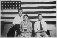
A view of the town in 1978 looking towards the old post office | |
 Location of Stringtown, Oklahoma | |
| Coordinates: 34°23′3″N 96°7′39″W / 34.38417°N 96.12750°WCoordinates: 34°23′3″N 96°7′39″W / 34.38417°N 96.12750°W | |
| Country | United States |
| State | Oklahoma |
| County | Atoka |
| Government | |
| • Chairman of the Board of Trustees | Toni Benson |
| Area | |
| • Total | 4.7 sq mi (12.2 km2) |
| • Land | 4.7 sq mi (12.1 km2) |
| • Water | 0.08 sq mi (0.2 km2) |
| Elevation | 627 ft (191 m) |
| Population (2010) | |
| • Total | 410 |
| • Density | 88/sq mi (33.9/km2) |
| Time zone | CST (UTC-6) |
| • Summer (DST) | CDT (UTC-5) |
| ZIP code | 74569 |
| Area code(s) | 580 |
| FIPS code | 40-70850[1] |
| GNIS feature ID | 1098585[2] |

Stringtown is a town in Atoka County, Oklahoma, United States. The population was 410 at the 2010 census,[3] an increase of 3.5 percent from 396 at the 2000 census. It is the second largest town in Atoka County.
The town is notable for the Mack H. Alford Correctional Center, a medium-security prison operated by the Oklahoma Department of Corrections, just outside Stringtown.
Geography
Stringtown is located at 34°28′6″N 96°3′10″W / 34.46833°N 96.05278°W (34.468448, -96.052860).[4]
According to the United States Census Bureau, the town has a total area of 4.7 square miles (12.2 km2), of which 4.7 square miles (12.1 km2) is land and 0.077 square miles (0.2 km2), or 1.24%, is water.[3]
Stringtown is located at the southern intersection of U.S. Highway 69 and State Highway 43.[5]
History

Originally named Springtown, for the natural springs that flow out of the hills the town is built upon, the current name is believed to be a corruption. Once home to a bank, theater and pub, the town has declined over the years, both economically and in population. In the past five years, small population growth and the addition of a new cafe have brought new life to the town. Annually in September, the Good Ole Days Festival celebrates the town's past with parade, cookout, and concert.
On August 5, 1932, while Bonnie Parker was visiting her mother, Clyde Barrow and two associates were drinking alcohol at a dance in Stringtown (illegal under Prohibition). When they were approached by Sheriff C. G. Maxwell and his deputy, Clyde opened fire, killing deputy Eugene C. Moore. That was the first killing of a lawman by what was later known as the Barrow Gang, a total which would eventually amount to nine slain officers.
In the 1940s during World War II, Fritz Johann Hansgirg, the Austrian inventor of magnesium and heavy water processes was interned at the U.S. alien internment camp located in Stringtown.
In the late 1960s, a tornado touched down in the town directly on top of the (then) recently built Community Center, now the Senior Citizens Center. The tornado was only on the ground for a few seconds, but during that time the building was almost completely destroyed. It was an unusual occurrence for a tornado to touch down in the town itself, given its being situated between two chains of steep hills.
The nearby Mack Alford State Penitentiary is a large source of employment in the county. It was an internment camp for Japanese Americans arrested as "enemy aliens" and later for German POWs during World War II.[6][7]
Despite its small size, Stringtown (2010 pop. 410) is the second-largest town in Atoka County, behind Atoka (pop. 3,107) and ahead of Tushka (pop. 312). On January 14, 2014, the Oklahoma Highway Patrol disbanded the Stringtown Police Department for generating too much of the city’s revenue off of writing traffic tickets, a violation of the state "speed trap" law.
Government and infrastructure

The United States Postal Service operates the Stringtown Post Office.[8]
The Oklahoma Department of Corrections operates the Mack Alford Correctional Center in an unincorporated area in Atoka County, near Stringtown.[9]
Demographics
| Historical population | |||
|---|---|---|---|
| Census | Pop. | %± | |
| 1920 | 360 | — | |
| 1930 | 558 | 55.0% | |
| 1940 | 718 | 28.7% | |
| 1950 | 499 | −30.5% | |
| 1960 | 414 | −17.0% | |
| 1970 | 397 | −4.1% | |
| 1980 | 1,047 | 163.7% | |
| 1990 | 366 | −65.0% | |
| 2000 | 1,474 | 302.7% | |
| 2010 | 410 | −72.2% | |
| Est. 2015 | 403 | [10] | −1.7% |
As of the census[1] of 2000, there were 396 people, 166 households, and 113 families residing in the town. The population density was 83.7 people per square mile (32.3/km²). There were 217 housing units at an average density of 45.9 per square mile (17.7/km²). The racial makeup of the town was 69.95% White, 11.36% African American, 10.35% Native American, 0.25% Asian, 0.25% Pacific Islander, and 7.83% from two or more races.
There were 166 households out of which 26.5% had children under the age of 18 living with them, 54.2% were married couples living together, 10.8% had a female householder with no husband present, and 31.9% were non-families. 28.9% of all households were made up of individuals and 14.5% had someone living alone who was 65 years of age or older. The average household size was 2.39 and the average family size was 2.89.
In the town the population was spread out with 24.0% under the age of 18, 9.6% from 18 to 24, 21.2% from 25 to 44, 27.5% from 45 to 64, and 17.7% who were 65 years of age or older. The median age was 42 years. For every 100 females there were 103.1 males. For every 100 females age 18 and over, there were 89.3 males.
The median income for a household in the town was $20,536, and the median income for a family was $22,614. Males had a median income of $19,643 versus $14,861 for females. The per capita income for the town was $9,612. About 15.1% of families and 25.1% of the population were below the poverty line, including 45.0% of those under age 18 and 30.9% of those age 65 or over.
Notable natives
- Reba McEntire, American country singer
- U L Washington, American former professional baseball player
References
- 1 2 "American FactFinder". United States Census Bureau. Retrieved 2008-01-31.
- ↑ "US Board on Geographic Names". United States Geological Survey. 2007-10-25. Retrieved 2008-01-31.
- 1 2 "Geographic Identifiers: 2010 Demographic Profile Data (G001): Stringtown town, Oklahoma". U.S. Census Bureau, American Factfinder. Retrieved July 16, 2013.
- ↑ "US Gazetteer files: 2010, 2000, and 1990". United States Census Bureau. 2011-02-12. Retrieved 2011-04-23.
- ↑ Official State Map (Map) (2008 ed.). Oklahoma Department of Transportation.
- ↑ "Stringtown (detention facility)" Densho Encyclopedia. Retrieved 2014-06-20.
- ↑ J. Burton, M. Farrell, F. Lord & R. Lord. Confinement and Ethnicity: An Overview of World War II Japanese American Relocation Sites, "U.S. Army Facilities: Stringtown, Oklahoma", (National Park Service, 2001); retrieved 2014-06-20.
- ↑ "Post Office Location - STRINGTOWN", United States Postal Service; retrieved November 22, 2010.
- ↑ "Mack Alford Correctional Center", Oklahoma Department of Corrections; retrieved November 22, 2010.
- ↑ "Annual Estimates of the Resident Population for Incorporated Places: April 1, 2010 to July 1, 2015". Retrieved July 2, 2016.
- ↑ "Census of Population and Housing". Census.gov. Retrieved June 4, 2015.
Municipalities and communities of Atoka County, Oklahoma, United States | ||
|---|---|---|
| City | 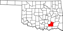 | |
| Towns | ||
| CDP | ||
| Other unincorporated communities | ||
| Ghost towns | ||