Kenedy, Texas
| Kenedy, Texas | |
|---|---|
| City | |
 Location of Kenedy, Texas | |
 | |
| Coordinates: 28°49′N 97°51′W / 28.817°N 97.850°WCoordinates: 28°49′N 97°51′W / 28.817°N 97.850°W | |
| Country | United States |
| State | Texas |
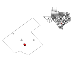
| County | Karnes |
| Government | |
| • Mayor | Randy Garza |
| Area | |
| • Total | 3.3 sq mi (8.6 km2) |
| • Land | 3.3 sq mi (8.6 km2) |
| • Water | 0.0 sq mi (0.0 km2) |
| Elevation | 266 ft (81 m) |
| Population (2000) | |
| • Total | 3,487 |
| • Density | 1,049.2/sq mi (405.1/km2) |
| Time zone | Central (CST) (UTC-6) |
| • Summer (DST) | CDT (UTC-5) |
| ZIP code | 78119 |
| Area code(s) | 830 |
| FIPS code | 48-38860[1] |
| GNIS feature ID | 1360572[2] |
Kenedy is a city in Karnes County, Texas, United States, named for Mifflin Kenedy,[3] who bought 400,000 acres (1,600 km2) and wanted to develop a new town that would carry his name. The population was 3,296 at the 2010 census.
History
In the early 1900s many of Kenedy's gunfighter shootings caused the town to be nicknamed "Six Shooter Junction".[4]
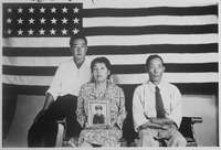
During World War 2, the Kenedy Alien Detention Camp was located near the outskirts of the town, on a former Civilian Conservation Corps site. Though it later served as a prisoner of war camp, it started as an internment camp for people of German, Italian and Japanese ancestry deported from Latin America, as well as some who were long-term residents of the U.S.[4][5] The camp opened in April 1942, when the first group of Latin American deportees arrived: 456 Germans, 156 Japanese and 14 Italians.[5] Despite State Department prisoner exchanges, in which German and Japanese Latin Americans were "repatriated" and traded for U.S. citizens in Axis custody, Kenedy's population swelled to 2,007 by October 1943: 1,168 Germans, 705 Japanese, 72 Italians, and 62 "miscellaneous."[5] The 705 of Japanese descent included U.S. civilians.[6] In 1944, the remaining internees were transferred to other facilities, and by September it had been converted to a German POW camp; beginning in July 1945, the camp was also used to house Japanese POWs.[6] The camp was closed at the end of the war, in September 1945.[5]
Kenedy is also the site of the John Connally Unit, a state prison. On December 13, 2000, a group called the Texas Seven escaped from that prison. They would go on a deadly crime spree before being caught.
Geography
Kenedy is located at 28°49′N 97°51′W / 28.817°N 97.850°W (28.8143, -97.8496).[7]
According to the United States Census Bureau, the city has a total area of 3.3 square miles (8.5 km2), all land.
Demographics
| Historical population | |||
|---|---|---|---|
| Census | Pop. | %± | |
| 1910 | 1,147 | — | |
| 1920 | 2,015 | 75.7% | |
| 1930 | 2,610 | 29.5% | |
| 1940 | 2,891 | 10.8% | |
| 1950 | 4,234 | 46.5% | |
| 1960 | 4,301 | 1.6% | |
| 1970 | 4,156 | −3.4% | |
| 1980 | 4,356 | 4.8% | |
| 1990 | 3,763 | −13.6% | |
| 2000 | 3,487 | −7.3% | |
| 2010 | 3,296 | −5.5% | |
| Est. 2015 | 3,421 | [8] | 3.8% |
As of the census[1] of 2000, there were 3,487 people, 1,266 households, and 907 families residing in the city. The population density was 1,049.2 people per square mile (405.5/km²). There were 1,550 housing units at an average density of 466.4/sq mi (180.3/km²). The racial makeup of the city was 72.44% White, 3.18% African American, 0.72% Native American, 0.72% Asian, 0.17% Pacific Islander, 20.68% from other races, and 2.09% from two or more races. Hispanic or Latino of any race were 64.90% of the population.
There were 1,266 households out of which 36.8% had children under the age of 18 living with them, 48.4% were married couples living together, 17.1% had a female householder with no husband present, and 28.3% were non-families. 25.8% of all households were made up of individuals and 13.2% had someone living alone who was 65 years of age or older. The average household size was 2.67 and the average family size was 3.20.
In the city the population was spread out with 29.0% under the age of 18, 9.4% from 18 to 24, 24.3% from 25 to 44, 19.8% from 45 to 64, and 17.5% who were 65 years of age or older. The median age was 36 years. For every 100 females there were 86.8 males. For every 100 females age 18 and over, there were 83.5 males.
The median income for a household in the city was $24,647, and the median income for a family was $25,152. Males had a median income of $25,779 versus $17,895 for females. The per capita income for the city was $13,929. About 23.4% of families and 25.8% of the population were below the poverty line, including 33.1% of those under age 18 and 11.9% of those age 65 or over.
Education
The City of Kenedy is served by the Kenedy Independent School District.
Notable people
- Blas Elias, musician.
- Carl Baugh, television show host.
- Cliff Gustafson, former college baseball coach who was, for twenty-nine seasons, the head coach of the The University of Texas at Austin baseball team.
- Mike Whitwell, NFL player
Climate
The climate in this area is characterized by hot, humid summers and generally mild to cool winters. According to the Köppen Climate Classification system, Kenedy has a humid subtropical climate, abbreviated "Cfa" on climate maps.[10]
References
- 1 2 "American FactFinder". United States Census Bureau. Retrieved 2008-01-31.
- ↑ "US Board on Geographic Names". United States Geological Survey. 2007-10-25. Retrieved 2008-01-31.
- ↑ Mifflin Kenedy from the Handbook of Texas Online
- 1 2 Handbook of Texas Online.
- 1 2 3 4 Mak, Stephen. "Kenedy (detention facility)" Densho Encyclopedia (accessed 17 Jun 2014).
- 1 2 J. Burton, M. Farrell, F. Lord, R. Lord. Confinement and Ethnicity: An Overview of World War II Japanese American Relocation Sites: "Department of Justice Internment Camps: Kenedy, Texas" National Park Service (accessed 17 Jun 2014).
- ↑ "US Gazetteer files: 2010, 2000, and 1990". United States Census Bureau. 2011-02-12. Retrieved 2011-04-23.
- ↑ "Annual Estimates of the Resident Population for Incorporated Places: April 1, 2010 to July 1, 2015". Retrieved July 2, 2016.
- ↑ "Census of Population and Housing". Census.gov. Retrieved June 4, 2015.
- ↑ Climate Summary for Kenedy, Texas
Municipalities and communities of Karnes County, Texas, United States | ||
|---|---|---|
| Cities | 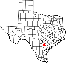 | |
| Town | ||
| Unincorporated communities | ||
| Ghost towns | ||