Turlock, California
| Turlock, California | |
|---|---|
| General law city[1] | |
| City of Turlock | |
|
Main Street in Turlock | |
 Location in Stanislaus County and the state of California | |
 Turlock, California Location in the United States | |
| Coordinates: 37°30′21″N 120°50′56″W / 37.50583°N 120.84889°WCoordinates: 37°30′21″N 120°50′56″W / 37.50583°N 120.84889°W | |
| Country |
|
| State |
|
| County | Stanislaus |
| Incorporated | February 15, 1908[2] |
| Government | |
| • Type | Council–manager[1] |
| • Mayor | Gary Soiseth[3] |
| • City Council |
Matthew Jacob[3] Amy Bublak[3] Bill DeHart, Jr.[3] Steven Nascimento[3] |
| • City Manager | Gary Hampton[4] |
| • City Attorney | Phaedra Norton[5] |
| Area[6] | |
| • Total | 16.928 sq mi (43.844 km2) |
| • Land | 16.928 sq mi (43.844 km2) |
| • Water | 0 sq mi (0 km2) 0% |
| Elevation[7] | 102 ft (31 m) |
| Population (2010)[8] | |
| • Total | 68,549 |
| • Estimate (July 1, 2015)[8] | 72,292 |
| • Density | 4,000/sq mi (1,600/km2) |
| Time zone | Pacific (UTC−8) |
| • Summer (DST) | PDT (UTC−7) |
| ZIP codes | 95380–95382 |
| Area code | 209 |
| FIPS code | 06-80812 |
| GNIS feature IDs | 277622, 2412114 |
| Website |
www |


Turlock is a city in Stanislaus County, California, United States. Its estimated 2015 population of 72,292[8] made it the second-largest city in Stanislaus County after Modesto.
Geography
Turlock lies in Stanislaus County, at 37°30′21″N 120°50′56″W / 37.50583°N 120.84889°W (37.505725, -120.849019),[9] between Modesto, California and Merced, California, at the intersection of State Route 99 and State Route 165. Its elevation is about 31 m (101 ft) above MSL. According to the United States Census Bureau, the town has a total area of 16.9 square miles (44 km2), all land.
Climate
Turlock has hot, mostly dry summers and cool, wet winters. Average January temperatures are a maximum of 53.7 °F (12.1 °C) and a minimum of 38.1 °F (3.4 °C). Average July temperatures are a maximum of 104.4 °F (40.2 °C) and a minimum of 62.6 °F (17.0 °C). There are an average of 78.0 days with highs of 90 °F (32 °C) or higher and an average of 19.8 days with lows of 32 °F (0 °C) or lower. The record high temperature was 114 °F (46 °C) on July 9, 1896. The record low temperature was 18 °F (−8 °C) on January 21, 1922, and December 19, 1924.
The average annual precipitation is 11.88 inches (302 mm). There are an average of 48 days with measurable precipitation. The wettest year was 1983 with 27.03 inches (687 mm) and the dryest year was 1953 with 5.32 inches (135 mm). The most precipitation in one month was 8.47 inches (215 mm) in February 1998. The most precipitation in 24 hours was 2.70 inches (69 mm) pm December 11, 1906. Although snow is very rare in Turlock, 3.0 inches (76 mm) fell in January 1922 and 2.0 inches (51 mm) fell in February 1976.[10]
History
Turlock was founded on December 22, 1871. Construction of the Central Pacific Railroad at that time had reached a station named after Turlough in County Mayo, Ireland. Thus, the new railroad town was named Turlock.
While it grew to be a relatively prosperous and busy hub of activity throughout the end of the 19th century, it was not incorporated as a city until February 15, 1908.[11] By that time intensive agricultural development surrounded most of the city (agriculture remains a major economic force in the region in current times). Many of the initial migrants to the region were Swedish. As an early San Francisco Chronicle article stated of the region and this community's lacteal productivity, "you have to hand it to the Scandinavians for knowing how to run a dairy farm."[12] Turlock went on to become known as the "Heart of the Valley" because of its agricultural production. With the boom came racial and labor strife. In July 1921, a mob of 150 white men evicted 60 Japanese cantaloupe pickers from rooming houses and ranches near Turlock, taking them and their belongings on trucks out of town.[13] The white men claimed the Japanese were undercutting white workers by taking lower wages per crate of fruit picked.[14] In protest, fruit growers briefly threatened not to hire the white workers behind the eviction, preferring to let melons rot on vines than hire such characters.[15] As a result of this stance, the eviction had the opposite effect of what the mob had intended. By August, Japanese workers had returned, and, moreover, they were nearly the only people employed to pick melons.[16] The affair gained national attention, and California's Governor William Stephens vowed that justice would be served.[17] Six men were quickly arrested, though they were apparently untroubled by the charges, stating that leaders of Turlock's American Legion and Chamber of Commerce had told them no trouble would come of their actions.[18] Although a former Turlock night watchman testified that one of the accused had disclosed a plan "to clean up Turlock of the Japs," all those arrested were later acquitted of charges.[19][20] The San Francisco Chronicle's editorial line was opposition to both the evictions and Japanese labor, with one column stating "we in California are determined that Oriental workers shall be kept out of the state. But that does not mean that the decent citizens of California will tolerate for one moment such proceedings as the attack of a mob on the Japanese cantaloupe workers in the Turlock district."[21]
As of 1930, Turlock's population was 20% Assyrian. They were such a significant part of the population that the southern part of town even became referred to as Little Urmia, referring to the region of northwestern Iran from which they largely came.[22] In the 1930s Turlock was cited by Ripley's Believe It or Not as having the most churches per capita in the U.S.; this had partly to do with the variety of ethnic churches, which were established for the relatively small settler population. Various religious centers reflecting a diverse population, such as Sikh Gurdwaras, various Assyrian Christian churches, and many mainline Protestant, Mormon and Roman Catholic churches have been built.
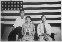
| Wikimedia Commons has media related to Turlock Assembly Center. |
During World War II, after the attack on Pearl Harbor, the U.S. government placed Japanese Americans into internment camps all over the country. The Stanislaus County Fairgrounds was the site of one of fifteen temporary "assembly centers" and held 3,669 Japanese Americans, a majority of them U.S. citizens.[23]
In 1960, California State University, Stanislaus, opened to students, helping to spur growth in the city as the university expanded in its early years. In the 1970s, State Route 99 (formerly U.S. Route 99) was completed through the area, largely bypassing the then-incorporated areas of Turlock in a route to the west of the city through mostly undeveloped land. Since that time, the city has grown westward considerably to meet the freeway's north-south path, although urban development west of the freeway has only recently begun to take hold. In an attempt to allow for orderly growth of the city, comprehensive growth master plans have established urban growth boundaries since the 1960s.
Turlock experienced extensive growth of both residential and commercial areas in the 1980s, following a statewide boom in housing demand and construction. The housing boom of the 1980s diminished in the early 1990s but increased again in the second half of the decade, partly as a result of San Francisco Bay Area growth, which placed a higher demand for more affordable housing in outlying areas. Following the dot-com bust, housing demand intensified, producing higher house prices in an area formerly known for affordable housing. A recent boom in the retail sector has produced considerable growth along Highway 99's corridor. The city's northern urban growth boundary, Taylor Road, was reached in the late 1990s. Growth beyond Taylor Road is restricted by the city's Master Plan.
Demographics
| Historical population | |||
|---|---|---|---|
| Census | Pop. | %± | |
| 1880 | 175 | — | |
| 1890 | 203 | 16.0% | |
| 1910 | 1,573 | — | |
| 1920 | 3,394 | 115.8% | |
| 1930 | 4,276 | 26.0% | |
| 1940 | 4,839 | 13.2% | |
| 1950 | 6,235 | 28.8% | |
| 1960 | 9,116 | 46.2% | |
| 1970 | 13,992 | 53.5% | |
| 1980 | 26,287 | 87.9% | |
| 1990 | 42,198 | 60.5% | |
| 2000 | 55,810 | 32.3% | |
| 2010 | 68,549 | 22.8% | |
| Est. 2015 | 72,292 | [24] | 5.5% |
2010
The 2010 United States Census[26] reported that Turlock had a population of 69,733. The population density was 4,049.4 people per square mile (1,563.5/km²). The racial makeup of Turlock was 47,864 (69.8%) White, 1,160 (1.7%) African American, 601 (0.9%) Native American, 3,865 (5.6%) Asian, 313 (0.5%) Pacific Islander, 11,328 (16.5%) from other races, and 3,418 (5.0%) from two or more races. Hispanic or Latino of any race were 24,957 persons (36.4%). The Census reported that 67,342 people (98.2% of the population) lived in households, 687 (1.0%) lived in non-institutionalized group quarters, and 520 (0.8%) were institutionalized.
There were 22,772 households, out of which 9,339 (41.0%) had children under the age of 18 living in them, 12,055 (52.9%) were opposite-sex married couples living together, 3,161 (13.9%) had a female householder with no husband present, 1,453 (6.4%) had a male householder with no wife present. There were 1,387 (6.1%) unmarried opposite-sex partnerships, and 153 (0.7%) same-sex married couples or partnerships. 4,755 households (20.9%) were made up of individuals and 2,058 (9.0%) had someone living alone who was 65 years of age or older. The average household size was 2.96. There were 16,669 families (73.2% of all households); the average family size was 3.45. The population was spread out with 18,820 people (27.5%) under the age of 18, 8,087 people (11.8%) aged 18 to 24, 18,313 people (26.7%) aged 25 to 44, 15,317 people (22.3%) aged 45 to 64, and 8,012 people (11.7%) who were 65 years of age or older. The median age was 32.5 years. For every 100 females there were 94.8 males. For every 100 females age 18 and over, there were 90.9 males.
There were 24,627 housing units at an average density of 1,454.8 per square mile (561.7/km²), of which 12,622 (55.4%) were owner-occupied, and 10,150 (44.6%) were occupied by renters. The homeowner vacancy rate was 2.6%; the rental vacancy rate was 9.0%. 37,867 people (55.2% of the population) lived in owner-occupied housing units and 29,475 people (43.0%) lived in rental housing units.
2000
As of the United States 2000 Census,[27] there are 55,810 people, 18,408 households, and 13,434 families residing in the city. The population density is 4,194.7 people per square mile (1,620.2/km²). There are 19,095 housing units at an average density of 1,435.2 per square mile (554.3/km²). The racial makeup of the city is 72.33% White, 1.43% African American, 0.94% Native American, 4.51% Asian, 0.27% Pacific Islander, 15.16% from other races, and 5.35% from two or more races. 29.42% of the population are Hispanic or Latino of any race.
4.9% of Turlock's population reported ancestry in the category Assyrian. This was the fourth highest percentage in the United States for this category, the highest for a community outside of Oakland County, Michigan and the only one of the top seven places in this category that was not one of Detroit's northern suburbs.[28]
There are 18,408 households out of which 40.3% have children under the age of 18 living with them, 54.8% are married couples living together, 13.1% have a female householder with no husband present, and 27.0% are non-families. 21.2% of all households are made up of individuals and 9.1% have someone living alone who is 65 years of age or older. The average household size is 2.92 and the average family size is 3.42. In the city the population is spread out with 29.8% under the age of 18, 11.4% from 18 to 24, 28.9% from 25 to 44, 18.1% from 45 to 64, and 11.8% who are 65 years of age or older. The median age is 31 years. For every 100 females there are 92.8 males. For every 100 females age 18 and over, there are 89.1 males. The median income for a household in the city is $39,050, and the median income for a family is $44,501. Males have a median income of $35,801 versus $27,181 for females. The per capita income for the city is $16,844. 16.2% of the population and 12.4% of families are below the poverty line. Out of the total population, 18.8% of those under the age of 18 and 9.8% of those 65 and older are living below the poverty line.
Culturally, the area is home to large concentrations of Americans of South Asian descent (particularly Sikhs), Mexican-Americans, and people of varied European descent. Swedes and Portuguese were early settlers to the area. Continued immigration from the Azores Islands (Portugal) in recent decades has established a large Portuguese-speaking community within the city. Turlock is a major center for the Assyrian community in the United States,[29] who began to arrive in the 1910s seeking opportunities in farming. By 1924 the Assyrian Evangelical Church was established and by the 1950s, 8% of the population of Turlock was Assyrian.[30] There was an increased influx into Turlock in the 1970s following political strife in Iraq and in the 1980s following the 1979 Islamic Revolution in Iran.
Government
Turlock uses a Council–Manager form of government. It is led by a five-member City Council consisting of a Mayor, a Vice-Mayor, and three Councilmembers. The Mayor is elected at-large, while each Councilmember is elected to one of four electoral districts.[31] All five Councilmembers are elected to four-year terms. A directly-elected City Treasurer also serves a four-year term.[32]
In the California State Legislature, Turlock is in the 8th Senate District, represented by Republican Tom Berryhill, and in the 12th Assembly District, represented by Republican Heath Flora.[33]
In the United States House of Representatives, Turlock is in California's 10th congressional district, represented by Republican Jeff Denham.[34]
Education
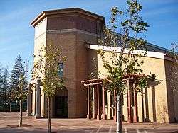
Turlock is the home of California State University, Stanislaus, a liberal arts university, and part of the 23-campus California State University system. As of 2013, CSU Stanislaus reported a student population of 7,754 undergraduate students. The number rises to 8,917 when considering all students, including graduate students.[35]
Turlock is home to two public high schools: Turlock High School and John H. Pitman High School as well as a continuation high schools, Roselawn High School,[36] which are part of the Turlock Unified School District. Turlock High School, the first in the city, opened in 1907, while Pitman opened in a major growth zone of northern Turlock in 2002. Pitman was awarded the California Distinguished School award in 2007, one of only two high schools in the county to receive the award for that year. Turlock Christian High School is a third, private high school within the city. Classes for Turlock Christian High School are held at Monte Vista Chapel, a church in Turlock. The city of Turlock has one junior high school, one middle school and nine elementary schools.[37]
Media
The Turlock Journal, a local newspaper, has been in continuous operation since 1904. Valley Entertainment Monthly, an entertainment newspaper covering the Central Valley, was published in Turlock in the early 1990s. Published in a review/interview format, VEM included interviews with Marvel Comics' Stan Lee, guitarist Ronnie Montrose, Green Lantern creator Mart Nodell and singer Kevin DuBrow, among others. Former writer's include Dave Meltzer, professional wrestling journalist and publisher/editor of the Wrestling Observer Newsletter.
Sports
The soccer Turlock Express team of the Major Arena Soccer League (MASL) an indoor soccer league plays in the Turlock Indoor Soccer Complex.[38] Turlock is home to the California State University, Stanislaus Warriors in the National Collegiate Athletic Association (NCAA).
Cultural references
Turlock and Turlock High School are briefly mentioned in the 1973 film American Graffiti.[39]
Notable residents
- Richard L. Bare, television director (Green Acres, The Twilight Zone)
- Tom Brandstater, NFL player (Denver, Indianapolis, Miami, St. Louis, Dallas Cowboys)
- Tony Corbin, football player
- Alison Cox, Olympic silver medalist, women's rowing, Athens 2004
- Lester Hayes, NFL athlete (Oakland Raiders)
- Dot Jones, athlete and actress
- Colin Kaepernick, NFL quarterback (San Francisco 49ers)
- Paul Larson, football player (Cal, Chicago Cardinals, Oakland Raiders)
- Brad Lesley, actor, MLB athlete (Cincinnati Reds, Milwaukee Brewers)
- Tommy Mendonca, MLB athlete (Philadelphia Phillies)
- James Mitchell, actor
- Oliver O'Grady, Irish defrocked Catholic priest
- Jonathan Quinn, football player (Jacksonville Jaguars, Kansas City, Chicago Bears)
- Cory Williams, actor and YouTube personality
See also
- MedicAlert, a non-profit, charitable, and membership-based organization for 24/7 medical response information, based in Turlock since its founding in 1956
- Lock-N-Stitch International, Turlock company repairing stress-induced cracks in metal objects
References
- 1 2 "About Turlock". City of Turlock. Retrieved February 6, 2015.
- ↑ "California Cities by Incorporation Date" (Word). California Association of Local Agency Formation Commissions. Retrieved August 25, 2014.
- 1 2 3 4 5 "Council Members". City of Turlock. Retrieved June 24, 2016.
- ↑ "City Manager's Office". City of Turlock. Retrieved June 24, 2016.
- ↑ "City Attorney". City of Turlock. Retrieved June 24, 2016.
- ↑ "2010 Census U.S. Gazetteer Files – Places – California". United States Census Bureau.
- ↑ "Turlock". Geographic Names Information System. United States Geological Survey. Retrieved October 19, 2014.
- 1 2 3 "Turlock (city) QuickFacts". United States Census Bureau. Retrieved August 18, 2016.
- ↑ "US Gazetteer files: 2010, 2000, and 1990". United States Census Bureau. 2011-02-12. Retrieved 2011-04-23.
- ↑ "TURLOCK #2, CALIFORNIA - Climate Summary". Wrcc.dri.edu. Retrieved 2012-06-18.
- ↑
- ↑ Bowles, EE (12 May 1914). "Turlock's Advance Indicative of Magic Wand". San Francisco Chronicle.
- ↑ "Deportation Made Quietly by 150 Men". San Francisco Chronicle. 21 July 1921.
- ↑ Meloy, Michael (2004). The Long Road to Manzanar. Ph.D. Diss., UC Davis. pp. 180–181.
- ↑ "White Workers Barred by Fruit Growers at Turlock". San Francisco Chronicle. 22 July 1921.
- ↑ "Turlock Left to Japanese Pickers". The Christian Science Monitor. 8 August 1921.
- ↑ "Turlock Japanese Assured Governor will Uphold Rights". San Francisco Chronicle. 22 July 1921.
- ↑ "Six Men Admit Aiding Turlock Deportations". San Francisco Chronicle. 24 July 1921.
- ↑ "Surprise at Deportation Trial Occurs". San Francisco Chronicle. 28 April 1922.
- ↑ "Turlock Men Acquitted of Riot Charges". San Francisco Chronicle. 6 May 1922.
- ↑ "Mobbing the Japanese". San Francisco Chronicle. 22 July 1921.
- ↑ Aprim, Fred. "The Assyrians of the San Joaquin Valley".
- ↑ Canelo, Kayla. "Turlock (detention facility)". Densho Encyclopedia. Retrieved 2014-08-13.
- ↑ "Annual Estimates of the Resident Population for Incorporated Places: April 1, 2010 to July 1, 2015". Retrieved July 2, 2016.
- ↑ "Census of Population and Housing". Census.gov. Archived from the original on May 11, 2015. Retrieved June 4, 2015.
- ↑ "2010 Census Interactive Population Search: CA - Turlock city". U.S. Census Bureau. Retrieved July 12, 2014.
- ↑ "American FactFinder". United States Census Bureau. Archived from the original on September 11, 2013. Retrieved 2008-01-31.
- ↑ "Assyrian-Chaldean-Syriac". Epodunk.com. Retrieved 2012-06-18.
- ↑ "The Assyrians of the San Joaquin Valley, California: From Early Settlements to the Present". Nineveh.com. Retrieved 2012-06-18.
- ↑ "Assyrian-Americans". Nineveh.com. 2001-09-02. Retrieved 2012-07-07.
- ↑ "District Boundary Map". City of Turlock. Retrieved June 24, 2016.
- ↑ "City Departments : Administrative Services". City of Turlock. Retrieved February 6, 2015.
- ↑ "Statewide Database". UC Regents. Retrieved December 3, 2014.
- ↑ "California's 10th Congressional District - Representatives & District Map". Civic Impulse, LLC. Retrieved September 28, 2014.
- ↑ "Fast Facts." California State University Stanislaus. Web. 30 Apr. 2016. <https://www.csustan.edu/about/fast-facts>.
- ↑ "Roselawn High School". Turlock.k12.ca.us. Retrieved 2012-07-07.
- ↑ https://turlockusd-ca.schoolloop.com/ourschools
- ↑ "Turlock Express - Professional Arena Soccer League (PASL) Indoor Soccer on OurSports Central". Oursportscentral.com. Retrieved 2012-06-18.
- ↑ "American Graffiti script". Subzin.com. Retrieved 2016-04-01.
External links
| Wikimedia Commons has media related to Turlock, California. |
- Official website
- Factual Information from www.city-data.com
- CNN Money Best Places to Live 2010 Turlock Comparison
Municipalities and communities of Stanislaus County, California, United States | ||
|---|---|---|
| Cities | 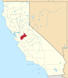 | |
| CDPs | ||
| Unincorporated communities | ||
| Ghost towns | ||