Split Mountain (California)
| Split Mountain | |
|---|---|
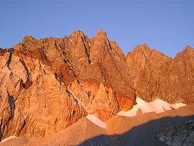 Sunrise on Split Mountain's east face, September 2004. | |
| Highest point | |
| Elevation | 14,064 ft (4,287 m) NAVD 88[1] |
| Prominence | 1,525 ft (465 m) [2] |
| Parent peak | North Palisade[3] |
| Listing |
|
| Coordinates | 37°01′15″N 118°25′21″W / 37.020941494°N 118.422410153°WCoordinates: 37°01′15″N 118°25′21″W / 37.020941494°N 118.422410153°W [1] |
| Geography | |
 Split Mountain
| |
| Location | Fresno / Inyo counties, California, United States |
| Parent range | Sierra Nevada |
| Topo map | USGS Split Mountain |
| Geology | |
| Mountain type | granite |
| Climbing | |
| First ascent | 1887, Frank Saulque and party[7] |
| Easiest route | North slope, scramble (class 2)[7] |
Split Mountain is a fourteener in the Sierra Nevada of the U.S. state of California, near the southeast end of the Palisades group of peaks. Its North Palisade, the tallest peak in the group and rises to 14,064 ft (4,287 m),[1] and is the eighth-highest peak in the state.[4]
Geography and Geology
Split Mountain's twin summits lie on a north-south running section of the Sierra crest. This same line of ridges divides Fresno County and Kings Canyon National Park to the west, from Inyo County and the Inyo National Forest to the east. The water divide of its ridges drain to the Kings River to the west, and the Owens River to the east.[2]
The two toned appearance of the mountain's eastern face is created by a roof pendant of darker colored granodiorite atop a lighter colored body of leucogranite.[8]
History
The name Split Mountain, inspired by the shape of its double summit, was first coined by mountaineer Bolton Brown in 1895. Alternately, it has been called Southeast Palisade or South Palisade.[9][10]
Climbing
Split Mountain is one of the easier California fourteeners to climb. The least technical route is the class 2 north slope, which can be approached from the west or east. Joseph LeConte, Helen LeConte and Curtis Lindley took the simple western approach from Upper Basin when they climbed Split Mountain on July 23, 1902. A more common route to the north face is from the east, by way of Red Lake. Starting at the Red Lake trailhead, this trail covers 6 miles (10 km) with 4,000 feet (1,220 m) of elevation gain one way to the lake. From here, another 3,500 ft (1,070 m) of cross-country climbing, including a short class 3 ridge traverse, leads to the summit.[7]
There are many more technical routes up both the north and south peaks of Split Mountain.[7]
See also
- List of mountain peaks of California
- List of California fourteeners
- The Palisades of the Sierra Nevada
References
- 1 2 3 "Split Mtn". NGS data sheet. U.S. National Geodetic Survey. Retrieved 2016-03-23.
- 1 2 "Split Mountain, California". Peakbagger.com. Retrieved 2009-02-28.
- ↑ "Southfork Pass". Peakbagger.com. Retrieved 2009-02-28.
- 1 2 "California 14,000-foot Peaks". Peakbagger.com. Retrieved 2012-11-07.
- ↑ "Sierra Peaks Section List" (PDF). Angeles Chapter, Sierra Club. Retrieved 2008-09-08.
- ↑ "Western States Climbers List". Climber.org. Retrieved 2016-03-24.
- 1 2 3 4 Secor, R.J. (2009). The High Sierra Peaks, Passes, and Trails (3rd ed.). Seattle: The Mountaineers. p. 222. ISBN 9780898869712.
- ↑ "GSA Field Forum - Rethinking the Assembly and Evolution of Plutons". Geological Society of America website. Retrieved 2008-09-08.
- ↑ "Split Mountain". Geographic Names Information System. United States Geological Survey. Retrieved 2009-06-30.
- ↑ Farquhar, Francis P. (1926). Place Names of the High Sierra. San Francisco: Sierra Club. Retrieved 2007-08-09.
External links
- "Split Mountain". SummitPost.org.
