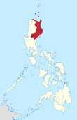
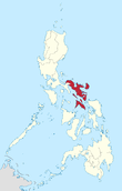
Luzon
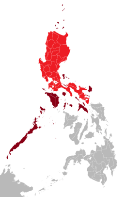 Luzon mainland in red; its associated islands in maroon | |
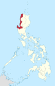
.svg.png) Luzon Location within the Philippines | |
| Geography | |
|---|---|
| Location | Southeast Asia |
| Coordinates | 16°00′N 121°00′E / 16.000°N 121.000°ECoordinates: 16°00′N 121°00′E / 16.000°N 121.000°E |
| Archipelago | Philippines |
| Adjacent bodies of water | |
| Major islands | |
| Area | 109,965 km2 (42,458 sq mi)[1] |
| Area rank | 15th |
| Highest elevation | 2,922 m (9,587 ft) |
| Highest point | Pulag |
| Administration | |
|
Philippines | |
| Regions | |
| Provinces |
List
|
| Largest settlement | Quezon City (pop. 2,761,720[2]) |
| Demographics | |
| Population | 52,990,000 (2015) |
| Pop. density | 441 /km2 (1,142 /sq mi) |
| Ethnic groups |
List
|
Luzon (![]() i/luːˈzɒn/; Tagalog pronunciation: [luˈson]) is the largest and most populous island in the Philippines and the 15th largest in the world. Located in the northern region of the archipelago, it is the economic and political center of the nation, being home to the country's capital city, Manila, as well as Quezon City, the country's most populous. With a population of 52.99 million as of 2015,[2] it is the fourth most populous island in the world (after Java, Honshu, and Great Britain), containing about 53% of the country's total population.
i/luːˈzɒn/; Tagalog pronunciation: [luˈson]) is the largest and most populous island in the Philippines and the 15th largest in the world. Located in the northern region of the archipelago, it is the economic and political center of the nation, being home to the country's capital city, Manila, as well as Quezon City, the country's most populous. With a population of 52.99 million as of 2015,[2] it is the fourth most populous island in the world (after Java, Honshu, and Great Britain), containing about 53% of the country's total population.
Luzon may also refer to one of the three primary island groups in the country. As such, it includes the Luzon mainland, the Batanes and Babuyan groups of islands to the north, Polillo Islands to the east, and the outlying islands of Catanduanes, Marinduque, Masbate, Romblon, Mindoro, and Palawan, among others, to the south.[3]
Etymology
The name Luzon is thought to derive from the Tagalog word lusong, which is a large wooden mortar used in dehusking rice.[4][5]
History
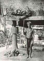
Luzon was once split among Hindu-Buddhist kingdoms, Muslim principalities, and ethnoreligious tribes, who had trading connections with Borneo, Malaya, Java, Indochina, India, Okinawa, Korea, Japan and China before the Spanish established their rule. From just before the first millennium, the Tagalog and Kapampangan peoples of south and central Luzon had established several Indianized kingdoms, notably among them those of Tundok and Namayan. The Laguna Copperplate Inscription, the first Philippine document written in 900AD, names places in and around Manila Bay as well as Medan in Indonesia.[6] These kingdoms were based on leases between village rulers (Datu) and landlords (Lakan) or Rajahs, to whom tributes and taxes were levied. These kingdoms were coastal thalassocracies based on trade with neighboring Asian political entities at that time. Some parts of Luzon were Islamized when the Sultanate of Brunei expanded its realms from Borneo to the Philippines and set up the Kingdom of Maynila as its puppet-state.[7] In addition, other kingdoms like the Huangdom of Ma-i and the Huangdom of Pangasinan had become tributary states to China and were largely Sinified kingdoms.[8]
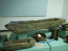
According to sources at the time, the trade in large native Ruson-tsukuri (literally Luzon made in Japanese:呂宋製 or 呂宋つくり) clay jars used for storing green tea and rice wine with Japan flourished in the 12th century, and local Tagalog, Kapampangan and Pangasinense potters had marked each jar with Baybayin letters denoting the particular urn used and the kiln the jars were manufactured in. Certain kilns were renowned over others and prices depended on the reputation of the kiln.[9][10] Of this flourishing trade, the Burnay jars of Ilocos are the only large clay jar manufactured in Luzon today with origins from this time.
The Yongle Emperor instituted a Chinese Governor on Luzon during Zheng He's voyages and appointed Ko Ch'a-lao to that position in 1405.[11][12] China also had vassals among the leaders in the archipelago.[13][14] China attained ascendancy in trade with the area in Yongle's reign.[15]
In the 1500s, people from Luzon were called Lucoes and were actively employed in trading, seafaring and military campaigns across Southeast Asia.
The Portuguese were the first European explorers who recorded it in their charts as Luçonia or Luçon and inhabitants were called Luçoes.[16] Edmund Roberts, who visited Luzon in the early 19th century, wrote that Luzon was "discovered" in 1521.[5] Many people from Luzon had active-employment in Portuguese Malacca. Lucoes such as the Luzon spice trader Regimo de Raja, based in Malacca, was highly influential and the Portuguese appointed him as Temenggong (Sea Lord) or a governor and police-chief general responsible for overseeing of maritime trade, at Malacca. His father and wife carried on his maritime trading business after his death. Another important Malacca trader was Curia de Raja who also hailed from Luzon. The "surname" of "de Raja" or "diraja" could indicate that Regimo and Curia, and their families, were of noble or royal descent as the term is an abbreviation of Sanskrit adiraja.[17]
Pinto noted that there were a number of Lucoes in the Islamic fleets that went to battle with the Portuguese in the Philippines during the 16th century. The Sultan of Aceh gave one of them (Sapetu Diraja) the task of holding Aru (northeast Sumatra) in 1540. Pinto also says one was named leader of the Malays remaining in the Moluccas Islands after the Portuguese conquest in 1511.[18] Pigafetta notes that one of them was in command of the Brunei fleet in 1521.[19]
However, the Luções did not only fight on the side of the Muslims. Pinto says they were also apparently among the natives of the Philippines who fought the Muslims in 1538.[18]
On Mainland Southeast Asia, Lusung/Lucoes warriors aided the Burmese king in his invasion of Siam in 1547 AD. At the same time, Lusung warriors fought alongside the Siamese king and faced the same elephant army of the Burmese king in the defence of the Siamese capital at Ayuthaya.[20]
Scholars have thus suggested that they could be mercenaries valued by all sides.[21][22][23]
The Spanish arrival in the 16th century saw the incorporation of the Lucoes people and the breaking up of their kingdoms and the establishment of the Las Islas Filipinas with its capital Cebu, which was moved to Manila following the defeat of the local Rajah Sulayman in 1570. Under Spain, Luzon also came to be known as the Nueva Castilla or the New Castile.
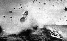
In World War II, the Philippines were considered to be of great strategic importance because their capture by Japan would pose a significant threat to the U.S. As a result, 135,000 troops and 227 aircraft were stationed in the Philippines by October 1941. Luzon was captured by Imperial Japanese forces in 1942 during their campaign to capture the Philippines. General Douglas MacArthur—who was in charge of the defense of the Philippines at the time—was ordered to Australia, and the remaining U.S. forces retreated to the Bataan Peninsula.[24]
A few months after this, MacArthur expressed his belief that an attempt to recapture the Philippines was necessary. The U.S. Pacific Commander Admiral Chester Nimitz and Chief of Naval Operations Admiral Ernest King both opposed this idea, arguing that it must wait until victory was certain. MacArthur had to wait two years for his wish; it was 1944 before a campaign to recapture the Philippines was launched. The island of Leyte was the first objective of the campaign, which was captured by the end of December 1944. This was followed by the attack on Mindoro and later, Luzon.[24]
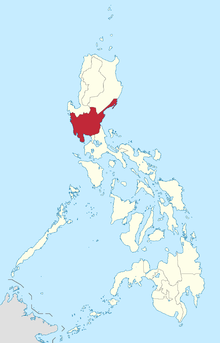
Geography
.jpg)
Luzon island alone has an area of 109,964.9 square kilometres (42,457.7 sq mi),[1] making it the world's 15th largest island. It is bordered on the west by the South China Sea (Luzon Sea in Philippine territorial waters), on the east by the Philippine Sea, and on the north by the Luzon Strait containing the Babuyan Channel and Balintang Channel. The mainland is roughly rectangular in shape and has the long Bicol Peninsula protruding to the southeast.
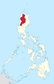
Luzon is roughly divided into four sections; Northern, Central and Southern Luzon, and the National Capital Region.
| Regions | Six divisions | Four divisions | Three divisions | Two divisions |
|---|---|---|---|---|
| Ilocos Region | Ilocandia | Northern Luzon | North and Central Luzon | North and Central Luzon |
| Cagayan Valley | ||||
| Cordillera Administrative Region | Cordilleras | |||
| Central Luzon | Central Luzon | |||
| National Capital Region | Metro Manila | Southern Luzon | ||
| Calabarzon | Southern Tagalog | Southern Luzon | Southern Luzon | |
| Mimaropa | ||||
| Bicol Region | Bicolandia | |||
Physical
Northern Luzon
The northwestern portion of the island, which encompasses most of the Ilocos Region, is characterized by a flat terrain extending east from the coastline toward the Cordillera Central mountains.
The Cordillera mountain range, which feature the island's north-central section, is covered in a mixture of tropical pine forests and montane rainforests, and is the site of the island's highest mountain, Mount Pulag, rising at 2,922 metres. The range provides the upland headwaters of the Agno River, which stretches from the slopes of Mount Data, and meanders along the southern Cordillera mountains before reaching the plains of Pangasinan.
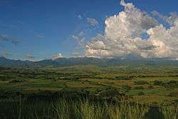
The northeastern section of Luzon is generally mountainous, with the Sierra Madre, the longest mountain range in the country, abruptly rising a few miles from the coastline. Located in between the Sierra Madre and the Cordillera Central mountain ranges is the large Cagayan Valley. This region, which is known for being the second largest producer of rice and the country's top corn-producer, serves as the basin for the Cagayan River, the longest in the Philippines.
Along the southern limits of the Cordillera Central lies the lesser-known Caraballo Mountains. These mountains form a link between the Cordillera Central and the Sierra Madre mountain ranges, separating the Cagayan Valley from the Central Luzon plains.[25]
Central Luzon
The central section of Luzon is characterized by a flat terrain, known as the Central Luzon plain, the largest in the island in terms of land area. The plain, approximately 11,000 square kilometres (4,200 sq mi) in size, is the country's largest producer of rice, and is irrigated by two major rivers; the Cagayan to the north, and the Pampanga to the south. In the middle of the plain rises the solitary Mount Arayat.
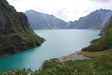
The western coasts of Central Luzon are typically flat extending east from the coastline to the Zambales Mountains, the site of Mount Pinatubo, made famous because of its enormous 1991 eruption. These mountains extend to the sea in the north, forming the Lingayen Gulf, and to the south, forming the Bataan Peninsula. The peninsula encloses the Manila Bay, a natural harbor considered to be one of the best natural ports in East Asia, due to its size and strategic geographical location.
The Sierra Madre mountain range continues to stretch across the western section of Central Luzon, snaking southwards into the Bicol Peninsula.
Southern Luzon
 1 2 3 4 5 6 7 8 9 | ||||||||||||||||||||
| ||||||||||||||||||||
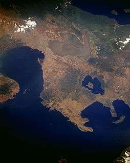
The northern section of Southern Luzon is dominated by the Laguna de Bay (Old Spanish, "Lake of Bay town"), the largest lake in the country. The 949-square-kilometre (366 sq mi) lake is drained into Manila Bay by the Pasig River, one of the most important rivers in the country due to its historical significance and because it runs through the center of Metro Manila.
Located 20 kilometres (12 mi) southwest of Laguna de Bay is Taal Lake, a crater lake containing the Taal Volcano, the smallest in the country. The environs of the lake form the upland Tagaytay Ridge, which was once part of a massive prehistoric volcano that covered the southern portion of the province of Cavite, Tagaytay City and the whole of Batangas province.
South of Laguna Lake are two solitary mountains, Mount Makiling in Laguna province, and Mount Banahaw, the highest in the region of Calabarzon.
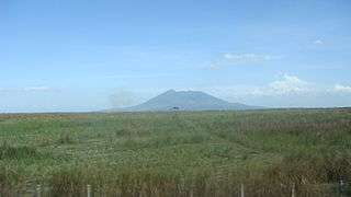
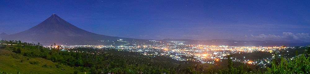
The southeastern portion of Luzon is dominated by the Bicol Peninsula, a mountainous and narrow region extending approximately 150 kilometres (93 mi) southeast from the Tayabas Isthmus in Quezon province to the San Bernardino Strait along the coasts of Sorsogon. The area is home to several volcanoes, the most famous of which is the 2,460-metre (8,070 ft) high symmetrically shaped Mayon Volcano in Albay province. The Sierra Madre range has its southern limits at Quezon province. Ultra-prominent mountains dot the landscape, which include Mount Isarog and Mount Iriga in Camarines Sur, and Mount Bulusan in Sorsogon.
The peninsula's coastline features several smaller peninsulas, gulfs and bays, which include Lamon Bay, San Miguel Bay, Lagonoy Gulf, Ragay Gulf, and Sorsogon Bay.
Outlying islands
Several outlying islands near mainland Luzon are considered part of the Luzon island group. The largest include Palawan, Mindoro, Masbate, Catanduanes, Marinduque, Romblon and Polillo.
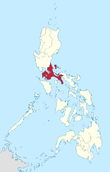
Administrative divisions
The island is covered by 7 administrative regions, 30 provinces and, as of 2014, 68 cities (8 regions, 38 provinces and 71 cities if associated islands are included).
| Location | Region (designation) |
Population (2010)[2] |
Area[lower-roman 1][26][27] | Density | Regional center |
|
|---|---|---|---|---|---|---|
 |
Ilocos Region (Region I) |
4,748,372 (5.1%) |
13,012.60 km2 (5,024.19 sq mi) |
360/km2 (930/sq mi) |
San Fernando (La Union) |
|
 |
Cagayan Valley (Region II) |
3,229,163 (3.5%) |
28,228.83 km2 (10,899.21 sq mi) |
110/km2 (280/sq mi) |
Tuguegarao | |
 |
Central Luzon (Region III) |
10,137,737 (11.0%) |
22,014.63 km2 (8,499.90 sq mi) |
460/km2 (1,200/sq mi) |
San Fernando (Pampanga) |
|
 |
Calabarzon (Region IV-A) |
12,609,803 (13.7%) |
16,873.31 km2 (6,514.82 sq mi) |
750/km2 (1,900/sq mi) |
Calamba | |
 |
Mimaropa[lower-roman 2] (Region IV-B) |
2,744,671 (3.0%) |
29,620.90 km2 (11,436.69 sq mi) |
93/km2 (240/sq mi) |
Calapan | |
 |
Bicol Region (Region V) |
5,420,411 (5.9%) |
18,155.82 km2 (7,010.00 sq mi) |
300/km2 (780/sq mi) |
Legazpi | |
 |
Cordillera Administrative Region (CAR) |
1,616,867 (1.8%) |
19,422.03 km2 (7,498.89 sq mi) |
83/km2 (210/sq mi) |
Baguio | |
 |
National Capital Region (NCR) |
11,855,975 (12.8%) |
611.39 km2 (236.06 sq mi) |
19,000/km2 (49,000/sq mi) |
Manila | |
| Region | 2010 census | Area | Density | Regional center | Component LGUs | |
| ||||||
Tectonics
Luzon is part of the Philippine Mobile Belt, a fast deforming plate boundary zone (Gervasio, 1967) hemmed in between two opposing subduction zones, the west-dipping Philippine Trench-East Luzon Trench subduction zone, and the east-dipping north-south trending Manila Trench-Negros Trench-Cotabato Trench.[28] The Philippine Sea Plate subducts under eastern Luzon along the East Luzon Trench and the Philippine Trench, while the South China Sea basin, part of the Eurasian plate, subducts under western Luzon along the Manila Trench.
The North-Southeastern trending braided left-lateral strike-slip Philippine Fault System traverses Luzon, from Quezon province and Bicol to the northwestern part of the island. This fault system takes up part of the motion due to the subducting plates and produces large earthquakes. Southwest of Luzon is a collision zone where the Palawan micro-block collides with SW Luzon, producing a highly seismic zone near Mindoro island. Southwest Luzon is characterized by a highly volcanic zone, called the Macolod Corridor, a region of crustal thinning and spreading.
Using geologic and structural data, seven principal blocks were identified in Luzon in 1989: the Sierra Madre Oriental, Angat, Zambales, Central Cordillera of Luzon, Bicol, and Catanduanes Island blocks.[29] Using seismic and geodetic data, Luzon was modeled by Galgana et al. (2007) as a series of six micro blocks or micro plates (separated by subduction zones and intra-arc faults), all translating and rotating in different directions, with maximum velocities ~100 mm/yr NW with respect to Sundaland/Eurasia.
Demographics
| Population census of Luzon | ||
|---|---|---|
| Year | Pop. | ±% p.a. |
| 1990 | 30,782,432 | — |
| 2000 | 39,584,158 | +2.55% |
| 2010 | 48,520,774 | +2.06% |
| Source: National Statistics Office[2] | ||
As of the 2010 census, the population of Luzon Island is 48,520,774 people,[2][30] making it the 4th most populated island in the world.
Ethnic groups
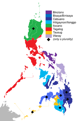
Six major Philippine ethnolinguistic groups predominate Luzon. Ilocanos dominate northern Luzon, while Kapampangans and Pangasinenses, as well as Tagalogs and Sambals, populate Central Luzon. Tagalogs dominate the National Capital Region, CALABARZON and the island provinces of Marinduque and Mindoro, while Bicolanos populate the southern Bicol peninsula. Visayans mainly predominate in the island provinces of Masbate, Palawan and Romblon.
Other ethnic groups lesser in population include the Aetas of Zambales and Bataan, the Ibanags of Cagayan and Isabela and the Igorot/Cordillerans of the Cordilleras.
Due to recent migrations populations of Hindus, Moros and Chinese have also been present in urban areas. Populations of Spanish, Americans, Japanese, Koreans, Indians, Arabs and Filipino mestizos are also visible. Most Americans have settled in the highly urbanized cities of Angeles and Olongapo due to the former presence of the U.S. air and naval bases in Central Luzon.
Languages
Almost all of the languages of Luzon belong to the Borneo–Philippines group of the Malayo-Polynesian language branch of the Austronesian language family. Major regional languages include: Tagalog, Ilocano, Bicolano, Kapampangan and Pangasinense.
English is spoken by many inhabitants. The use of Spanish as an official language declined following the American occupation of the Philippines. Almost inexistent among the general populace, Spanish is still used by the elderly of some families of great tradition (Rizal, Liboro...).
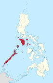
Religion
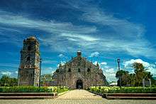
Like most of the Philippines, the major religion in Luzon is Christianity, with Roman Catholicism being the major denomination. Other major sects includes Jehovah's Witnesses, Protestantism, the Philippine Independent Church, and the Iglesia ni Cristo.[31] Indigenous traditions and rituals, though rare, are also present.
There are also sizable communities of Hindus, Buddhists and Muslims in Metro Manila and in other, especially, urban areas due to the immigration of Moros and Chinese to the island.
.JPG)
Economy
The economy of the island is centered in Metro Manila with Makati serving as the main economic and financial hub. Major companies such as Ayala, Jollibee Foods Corporation, SM Group, and Metrobank are based in the business districts of Makati, Ortigas Center, and Bonifacio Global City. Industry is concentrated in and around the urban areas of Metro Manila while agriculture predominates in the other regions of the island producing crops such as rice, bananas, mangoes, coconuts, pineapple, and coffee.[32] Other sectors include livestock raising, tourism, mining, and fishing.
See also
References
- 1 2 "Islands by Land Area". Island Directory Tables. United Nations Environment Programme. Retrieved 4 March 2013.
- 1 2 3 4 5 "Population and Annual Growth Rates for The Philippines and Its Regions, Provinces, and Highly Urbanized Cities; Based on 1990, 2000, and 2010 Censuses" (PDF). 2010 Census and Housing Population. National Statistics Office. Retrieved 13 February 2013.
- ↑ Zaide, Sonia M. The Philippines, a Unique Nation. p. 50.
- ↑ Keat Gin Ooi (2004). Southeast Asia: A Historical Encyclopedia, from Angkor Wat to East Timor. ABC-CLIO. p. 798. ISBN 978-1-57607-770-2.
- 1 2 Roberts, Edmund (1837). Embassy to the Eastern Courts of Cochin-China, Siam, and Muscat. New York: Harper & Brothers. p. 59.
- ↑ Laguna Copperplate Inscription – Article in English. Mts.net (2006-07-14). Retrieved on 2010-12-19.
- ↑ Frans Welman (1 August 2013). Borneo Trilogy Brunei: Vol 1. Booksmango. pp. 8–. ISBN 978-616-222-235-1.
- ↑ William Henry Scott (1983). "The fact that Chief Kamayin's name is transliterated by the Chinese characters for "excellent," "horse," and' "silver" led Berthold Laufer in his 1907 "The relations of the Chinese to the Philippines" to list horses and silver among the Pangasinan gifts (Historical Bulletin 1967 reprint, Vol. 11, p. 10); this error was carelessly copied by Wu Ching-hong in his 1962 "The rise and decline of Chuanchou's international trade" (Proceedings of the Second Conference of the International Association of Historians of Asia, p. 477), whence it passed into more than one Philippine text, but was not repeated by Wu himself in his later works.Laufer also refers to a Philippine embassy led by a "high official called Ko-ch'a-lao" whom no other scholar has been able to locate and whom Beyer identifies as a "Chinese governor appointed for the island of Luzon" (op. cit., loc. cit.)." (PDF). Guttenburg Free Online E-books. 1: 8.
- ↑ Kekai, Paul. (2006-09-05) Quests of the Dragon and Bird Clan: Luzon Jars (Glossary). Sambali.blogspot.com. Retrieved on 2010-12-19.
- ↑ South East Asia Pottery – Philippines. Seapots.com. Retrieved on 2010-12-19. Archived October 19, 2014, at the Wayback Machine.
- ↑ Ho 2009, p. 33.
- ↑ "In Our Image". google.com. Retrieved 24 August 2015.
- ↑ Yust 1949, p. 75.
- ↑ Yust 1954, p. 75.
- ↑ "Philippine Almanac & Handbook of Facts" 1977, p. 59.
- ↑ Pires, Tomé, A suma oriental de Tomé Pires e o livro de Francisco Rodriguez: Leitura e notas de Armando Cortesão [1512–1515], translated and edited by Armando Cortesao, Cambridge: Hakluyt Society, 1944.
- ↑ Junker, 400. http://sambali.blogspot.com/2014/12/the-borneo-route.html
- 1 2 Pinto, Fernao Mendes (1989) [1578]. "The travels of Mendes Pinto.". Translated by Rebecca Catz. Chicago: University of Chicago Press.
- ↑ Pigafetta, Antonio (1969) [1524]. "First voyage round the world". Translated by J.A. Robertson. Manila: Filipiniana Book Guild.
- ↑ Pigafetta 1524, p. 195.
- ↑ Pires, Tomé (1944). Armando Cortesao (translator), ed. A suma oriental de Tomé Pires e o livro de Francisco Rodriguez: Leitura e notas de Armando Cortesão [1512 - 1515] (in Portuguese). Cambridge: Hakluyt Society.
- ↑ Lach, Donald Frederick (1994). "Chapter 8: The Philippine Islands". Asia in the Making of Europe. Chicago: University of Chicago Press. ISBN 0-226-46732-5.
- ↑ Reid, Anthony (1995). "Continuity and Change in the Austronesian Transition to Islam and Christianity". In Peter Bellwood; James J. Fox; Darrell Tryon. The Austronesians: Historical and comparative perspectives. Canberra: Department of Anthropology, The Australian National University.
- 1 2 "The Philippines". Retrieved 6 December 2008.
- ↑ Smith, Robert Ross (1993). Triumph in the Philippines (Transcribed and formatted by Jerry Holden for the HyperWar Foundation). Honolulu, HI: University Press of the Pacific. p. 450. ISBN 1410224953. Retrieved 25 December 2014.
- ↑ "PSGC Interactive; List of Provinces". Philippine Statistics Authority. Retrieved 3 April 2016.
- ↑ "PSGC Interactive; List of Cities". Philippine Statistics Authority. Retrieved 7 April 2016.
- ↑ Hashimoto, M, ed., Accretion Tectonics in the Circum-Pacific Regions, ISBN 90-277-1561-0 p299
- ↑ Rangin and Pubellier in Tectonics of Circum-Pacific Continental Margins ISBN 90-6764-132-4 p148 fig 4
- ↑ Figure composed of the 8 administrative regions excluding the island provinces of Batanes, Catanduanes, and Masbate and the region MIMAROPA
- ↑ PHILIPPINES: ADDITIONAL THREE PERSONS PER MINUTE, National Statistics Office. Last revised: July 18, 2003. Retrieved November 27, 2006.
- ↑ Index of Agriculture and Fishery Statistics. Census.gov.ph. Retrieved on 2010-12-19. Archived February 21, 2012, at the Wayback Machine.
Further reading
- Agoncillo, Teodoro A.; Guerrero, Milagros (1975). History of the Filipino People (4 ed.). R. P. Garcia. ISBN 9712345386. Retrieved 24 April 2014.
- Agoncillo, Teodoro A. (1962). Philippine History. Inang Wika Publishing Company. ISBN 9712345386. Retrieved 24 April 2014.
- Alip, Eufronio Melo (1954). Political and Cultural History of the Philippines, Volumes 1-2 (revised ed.). Alip & Sons. Retrieved 24 April 2014.
- Antonio, Eleanor D.; Dallo, Evangeline M.; Imperial, Consuelo M.; Samson, Maria Carmelita B.; Soriano, Celia D. (2007). Turning Points I' 2007 Ed. (unabridged ed.). Rex Bookstore, Inc. ISBN 9712345386. Retrieved 24 April 2014.
- Bishop, Carl Whiting (1942). War Background Studies, Issues 1-7. Contributor: Smithsonian Institution. Smithsonian Institution. Retrieved 24 April 2014.
- Bishop, Carl Whiting (1942). Origin of Far Eastern Civilizations: A Brief Handbook, Issues 1-7. Contributor: Smithsonian Institution. Smithsonian Institution. Retrieved 24 April 2014.
- Corpuz, Onofre D. (1957). The bureaucracy in the Philippines. Institute of Public Administration, University of the Philippines. Retrieved 24 April 2014.
- Demetrio, Francisco R. (1981). Myths and Symbols: Philippines (2 ed.). National Book Store. Retrieved 24 April 2014.
- Del Castillo y Tuazon, Antonio (1988). Princess Urduja, Queen of the Orient Seas: Before and After Her Time in the Political Orbit of the Shri-vi-ja-ya and Madjapahit Maritime Empire : a Pre-Hispanic History of the Philippines. A. del. Castillo y Tuazon. Retrieved 24 April 2014.
- Farwell, George (1967). Mask of Asia: The Philippines Today. Praeger. Retrieved 24 April 2014.
- Fitzgerald, Charles Patrick (1966). A concise history of East Asia. Praeger. Retrieved 24 April 2014.
- Ho, Khai Leong, ed. (2009). Connecting and Distancing: Southeast Asia and China (illustrated ed.). Institute of Southeast Asian Studies. ISBN 9812308563. Retrieved 24 April 2014.
- Karnow, Stanley (2010). In Our Image: America's Empire in the Philippines (unabridged ed.). Random House LLC. ISBN 0307775437. Retrieved 24 April 2014.
- Krieger, Herbert William (1942). Peoples of the Philippines, Issue 4. Volume 3694 of Publication (Smithsonian Institution). Smithsonian Institution. Retrieved 24 April 2014.
- Lucman, Norodin Alonto (2000). Moro Archives: A History of Armed Conflicts in Mindanao and East Asia. FLC Press. Retrieved 24 April 2014.
- Liao, Shubert S. C., ed. (1964). Chinese participation in Philippine culture and economy. Bookman. Archived from the original on Nov 9, 2006. Retrieved 24 April 2014.
- Manuel, Esperidion Arsenio (1948). Chinese Elements in the Tagalog Language: With Some Indication of Chinese Influence on Other Philippine Languages and Cultures, and an Excursion Into Austronesian Linguistics. Contributor: Henry Otley Beyer. Filipiniana Publications. Retrieved 24 April 2014.
- Ostelius, Hans Arvid (1963). Islands of Pleasure: A Guide to the Philippines. G. Allen & Unwin. Retrieved 24 April 2014.
- Panganiban, José Villa; Panganiban, Consuelo Torres (1965). The literature of the Pilipinos: a survey (5 ed.). Limbagang Pilipino. Retrieved 24 April 2014.
- Panganiban, José Villa; Panganiban, Consuelo Torres- (1962). A Survey of the Literature of the Filipinos (4 ed.). Limbagang Pilipino. Retrieved 24 April 2014.
- Quirino, Carlos (1963). Philippine Cartography, 1320-1899 (2 ed.). N. Israel. Retrieved 24 April 2014.
- Ravenholt, Albert (1962). The Philippines: A Young Republic on the Move. Van Nostrand. Retrieved 24 April 2014.
- Sevilla, Fred; Balagtas, Francisco (1997). Francisco Balagtas and the roots of Filipino nationalism: life and times of the great Filipino poet and his legacy of literary excellence and political activism. Trademark Pub. Corp. Retrieved 24 April 2014.
- Spencer, Cornelia (1951). Seven Thousand Islands: The Story of the Philippines. Aladdin Books. Retrieved 24 April 2014.
- Tan, Antonio S. (1972). The Chinese in the Philippines, 1898-1935: A Study of Their National Awakening. R. P. Garcia Publishing Company. Retrieved 24 April 2014.
- Yust, Walter, ed. (1949). Encyclopaedia britannica: a new survey of universal knowledge, Volume 9. Encyclopaedia Britannica. Retrieved 24 April 2014.
- Encyclopædia Britannica, Volume 9. Volume 9 of EncyclopÆdia Britannica: A New Survey of Universal Knowledge. Contributor: Walter Yust. EncyclopÆdia Britannica. 1954. Retrieved 24 April 2014.
- Zaide, Gregorio F. (1957). The Philippines since pre-Spanish times.-v. 2. The Philippines since the British invasion. Volume 1 of Philippine Political and Cultural History (revised ed.). Philippine Education Company. Retrieved 24 April 2014.
- Zaide, Gregorio F. (1979). The Pageant of Philippine History: Political, Economic, and Socio-cultural, Volume 1. Philippine Education Company. Retrieved 24 April 2014.
- Philippines (Republic). Office of Cultural Affairs (1965). The Philippines: a Handbook of Information. Contributor: National Economic Council (Philippines) (revised ed.). Republic of the Philippines, Department of Foreign Affairs. Retrieved 24 April 2014.
- Philippine Chinese Historical Association (1975). The Annals of Philippine Chinese Historical Association, Volumes 5-8 (revised ed.). Retrieved 24 April 2014.
- IAHA Conference (1962). Biennial Conference Proceedings, Issue 1. Philippine Historical Association. Retrieved 24 April 2014.
- The Philippines: A Handbook of Information. Contributor: Philippine Information Agency. Philippine Information Agency. 1955. Retrieved 24 April 2014.
- University of Manila Journal Of East Asiatic Studies, Volume 7. Contributors: Manila (Philippines) University, University of Manila (revised ed.). University of Manila. 1959. Retrieved 24 April 2014.
- Unitas, Volume 30, Issues 1-2. Contributor: University of Santo Tomás. University of Santo Tomás. 1957. Retrieved 24 April 2014.
- The Researcher, Volume 2, Issue 2. Contributors: University of Pangasinan, Dagupan Colleges. Dagupan Colleges. 1970. Retrieved 24 April 2014.
- Philippine Social Sciences and Humanities Review, Volumes 24-25. Contributor: University of the Philippines. College of Liberal Arts. 1959. Retrieved 24 April 2014.
- Philippine Social Sciences and Humanities Reviews, Volume 24, Issues 1-2. Contributors: Philippine Academy of Social Sciences, Manila, University of the Philippines. College of Liberal Arts. College of Liberal Arts, University of the Philippines. 1959. Retrieved 24 April 2014.
- Studies in Public Administration, Issue 4. Contributor: University of the Philippines. Institute of Public Administration. Institute of Public Administration, University of the Philippines. 1957. Retrieved 24 April 2014.
- Proceedings [of The] Second Biennial Conference, Held at Taiwan Provincial Museum, Taipei, Taiwan. Republic of China, October 6-9, 1962. Tʻai-pei. 1963. Retrieved 24 April 2014.
- Yearbook. 1965. Retrieved 24 April 2014.
- Philippine Almanac & Handbook of Facts. 1977. Retrieved 24 April 2014.
External links
| Wikinews has news related to: |
-
 Media related to Luzon at Wikimedia Commons
 -
 The dictionary definition of Luzon at Wiktionary
 -
 Luzon travel guide from Wikivoyage
 -
 Geographic data related to Luzon at OpenStreetMap
 -
 "Luzon". The American Cyclopædia. 1879.

