Alabat Island
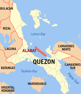 Location within Quezon province | |
.svg.png) Alabat Island Location within the Philippines | |
| Geography | |
|---|---|
| Location | Lamon Bay |
| Coordinates | 14°7′4″N 122°3′6″E / 14.11778°N 122.05167°ECoordinates: 14°7′4″N 122°3′6″E / 14.11778°N 122.05167°E |
| Adjacent bodies of water | Philippine Sea |
| Area | 192 km2 (74 sq mi) |
| Administration | |
| Region | CALABARZON |
| Province | Quezon |
| Municipalities | |
| Largest settlement | Alabat (pop. 16,120) |
| Demographics | |
| Population | 41822 |
Alabat Island is an island of the Philippine archipelago, in the Quezon Province of the CALABARZON region, situated just off the east coast of Southern Luzon. The island has an area of 192 square kilometres (74 sq mi) and a population of 41,822.
Alabat Island comprises 3 municipalities, Perez in the northern tip, Alabat town proper in the center and Quezon in the south.
The island is located in the Lamon Bay and (33 km long) has an extensive mangrove fringe along its southwest shore, with several hundred hectares of intertidal mudflats exposed at low tide. Large portions of the original mangrove forest have been degraded or completely destroyed for the construction of fish and shrimp ponds.
Alabat enjoys a humid tropical climate with no dry season, but a very pronounced period of maximum rainfall from November to January.
External links
-
 Geographic data related to Alabat Island at OpenStreetMap