Eastern Samar
| Eastern Samar | |||
|---|---|---|---|
| Province | |||
| Province of Eastern Samar | |||
| |||
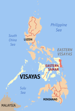 Location in the Philippines | |||
| Coordinates: 11°40′N 125°30′E / 11.67°N 125.5°ECoordinates: 11°40′N 125°30′E / 11.67°N 125.5°E | |||
| Country | Philippines | ||
| Region | Eastern Visayas (Region VIII) | ||
| Founded | June 19, 1965 | ||
| Capital | Borongan | ||
| Government | |||
| • Type | Sangguniang Panlalawigan | ||
| • Governor | Conrado B. Nicart, Jr. (Liberal) | ||
| • Vice Governor | Marcelo Picardal (LDP) | ||
| Area[1] | |||
| • Total | 4,660.47 km2 (1,799.42 sq mi) | ||
| Area rank | 24th out of 81 | ||
| Population (2015 census)[2] | |||
| • Total | 467,160 | ||
| • Rank | 58th out of 81 | ||
| • Density | 100/km2 (260/sq mi) | ||
| • Density rank | 69th out of 81 | ||
| Divisions | |||
| • Independent cities | 0 | ||
| • Component cities |
1
| ||
| • Municipalities | |||
| • Barangays | 597 | ||
| • Districts | Lone district of Eastern Samar | ||
| Time zone | PHT (UTC+8) | ||
| ZIP code | 6800–6822 | ||
| IDD : area code | +63 (0)55 | ||
| ISO 3166 code | PH-EAS | ||
| Spoken languages | |||
| Website |
www | ||


Eastern Samar (Waray-Waray: Sidlangan nga Samar; Tagalog: Silangang Samar) is a province in the Philippines located in the Eastern Visayas region. Its capital is the city of Borongan. Eastern Samar occupies the eastern portion of the island of Samar. Bordering the province to the north is the province of Northern Samar and to the west is Samar province. To the east lies the Philippine Sea, part of the vast Pacific Ocean, while to the south lies the Leyte Gulf.
History
Colonial period
During his circumnavigation of the globe, Ferdinand Magellan had set foot on the tiny island of Homonhon in the southern part of the province. On March 16, 1521, the area of what is now Eastern Samar is said to be the first Philippine landmass spotted by Magellan and his crew.[3][4][5]
On September 28, 1901 during the Philippine-American War, Filipino guerrillas in Balangiga ambushed American troops, killing 48 members of the US 9th Infantry. The incident triggered the infamous American retaliation against the Samar populace and guerrillas.[5]
During the Second World War in 1944, Americans involved in the liberation of the Philippines from Japan built in the town of Guiuan the largest military base in the Pacific. In the same town in 1949, approximately 5,000 Russian refugees escaping from communist China temporarily settled on Tubabao Island until 1951, when they were transferred to Australia and the United States.[4]
Independent province
Eastern Samar, as a province, was created from Samar province through Republic Act No. 4221 on June 19, 1965.[6] Congressmen Eladio T. Balite (1st Dist. Samar), Fernando R. Veloso (2nd Dist. Samar), and Felipe J. Abrigo (3rd Dist. Samar), authored Republic Act 4221 which was approved by Congress in 1963. The law, ratified in a plebiscite on June 19, 1965, divided Samar into three: Northern Samar, Eastern Samar and (Western) Samar.
Typhoon Haiyan (Yolanda), one of the strongest typhoons ever recorded, made its first landfall in the coastal town of Guiuan on November 2013.[7]
Geography
Eastern Samar covers a total area of 4,660.47 square kilometres (1,799.42 sq mi)[8] occupying the eastern section of Samar island in the Eastern Visayas region. The province is bordered to the north by Northern Samar and to the west by Samar. To the east lies the Philippine Sea, part of the vast Pacific Ocean, while to the south lies the Leyte Gulf.
Because it faces the Philippine Sea of the Pacific Ocean, Eastern Samar suffers heavily from powerful typhoons.[3]
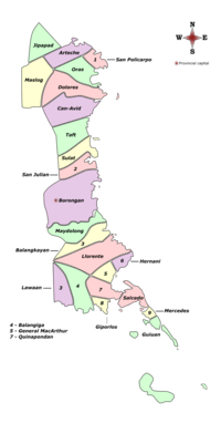
Administrative divisions
Eastern Samar comprises 22 municipalities and one city, all encompassed by a single legislative district.
|
 | |||||||||||||||||||||||||||||||||||||||||||||||||||||||||||||||||||||||||||||||||||||||||||||||||||||||||||||||||||||||||||||||||||||||||||||||||||||||||||||||||||||||||||||||||||||||||||||||||||||||||||||||||||||||||||||||||||||||||||||||||||||||||||||||||||||||||||||||||||||||||||||||||||||||||||||||||||||||||||||||||||||||||||||||||
Demographics
| Population census of Eastern Samar | ||
|---|---|---|
| Year | Pop. | ±% p.a. |
| 1990 | 329,335 | — |
| 1995 | 362,324 | +1.80% |
| 2000 | 375,822 | +0.79% |
| 2007 | 405,114 | +1.04% |
| 2010 | 428,877 | +2.10% |
| 2015 | 467,160 | +1.64% |
| Source: National Statistics Office[2][9][9] | ||
The population of Eastern Samar in the 2015 census was 467,160 people,[2] with a density of 100 inhabitants per square kilometre or 260 inhabitants per square mile. The predominant language is Waray.[5]
In the 2000 Census, Warays comprised 97.78% (366,787) of the total provincial population of 375,124 at that time. Kapampangan came second at 0.55% (2,067), Bisaya/Binisaya 0.43% (1,613), Cebuano at 0.18% (680), and Tagalog at 0.17% (621).[10]
Religion
The people of the province are devoted Christians where a majority adhere to Roman Catholicism.[5] The dominant Catholic faith influences the events of the provincial education, politics and social functions of the people. Other Christians usually form the remaining groups of believers such as the Born-again Christians, Protestants, Jehovah's Witnesses, Iglesia Ni Cristo, Baptists, Methodists, The Church of Jesus Christ of Latter-day Saints, and Seventh-day Adventists. Non Christians (mostly Muslims) are also found.
Transportation
The province has one operational airport; Borongan Airport located in the capital city. Currently, only SkyJet Airlines operates out of Borongan Airport with flights weekly to serve locals and tourists to and from Manila.
By land, mini buses and vans ply from the regional center in Tacloban City to some towns in Eastern Samar. From Borongan City, buses ply to Manila. Motorized boats plies through the Leyte Gulf ferrying passengers going to Tacloban City seaport.
Economy
Commercial activities in the province are centered on the provincial capital of Borongan City while tourism activities are centered in Guiuan town where Calicoan Island and the historical Homonhon Island are located.[5] Generally, the province's major economic resource is fishery and agriculture which include production of coconut, copra, corn, rice, sugar, and vegetables.[5] Tourism potential is untapped on the northern part of the province.
References
- ↑ "List of Provinces". PSGC Interactive. Makati City, Philippines: National Statistical Coordination Board. Retrieved 13 April 2013.
- 1 2 3 4 "Region VIII (EASTERN VISAYAS)". Census of Population (2015): Total Population by Province, City, Municipality and Barangay (Report). PSA. Retrieved 20 June 2016.
- 1 2 Lancion, Jr., Conrado M.; cartography by de Guzman, Rey (1995). "The Provinces; Eastern Samar". Fast Facts about Philippine Provinces (The 2000 Millenium ed.). Makati, Metro Manila, Philippines: Tahanan Books. p. 72. ISBN 971-630-037-9. Retrieved 4 December 2015.
- 1 2 Labro, Vicente S. (11 June 2011). "Guiuan's treasure chest of history, natural wonders". Philippine Daily Inquirer. Retrieved 24 April 2016.
- 1 2 3 4 5 6 "The Province of Eastern Samar". National Statistical Coordination Board. Retrieved 24 April 2016.
- ↑ "Republic Act No. 4221 - An Act Creating the Provinces of Northern Samar, Eastern Samar and Western Samar". Chan Robles Virtual Law Library. Retrieved 19 December 2015.
- ↑ Baylis, Paul; Te-Ping Chen (22 November 2013). "How One Philippine Town Avoided Calamity". The Wall Street Journal. Retrieved 20 December 2015.
- 1 2 "Province: Eastern Samar". PSA. Philippines: National Statistical Coordination Board. Retrieved 8 January 2016.
- 1 2 3 "Region VIII (EASTERN VISAYAS)". Census of Population and Housing (2010): Total Population by Province, City, Municipality and Barangay (Report). NSO. Retrieved 29 June 2016.
- 1 2 "Eastern Samar: Home of the Warays; Table 4. Household Population by Ethnicity and Sex: Eastern Samar, 2000". National Statistics Office. 7 June 2002. Archived from the original on 16 November 2013. Retrieved 25 July 2016.
External links
-
 Eastern Samar travel guide from Wikivoyage
 -
 Media related to Eastern Samar at Wikimedia Commons
 -
 Geographic data related to Eastern Samar at OpenStreetMap
 - Philippine Standard Geographic Code
- Local Governance Performance Management System
 |
Northern Samar | | ||
| Samar | |
Philippine Sea | ||
| ||||
| | ||||
| Leyte Gulf Dinagat Islands |
Borongan (capital) | |
| Municipalities | |
| Component city | |


