Cagayan
| Cagayan | |||
|---|---|---|---|
| Province | |||
| Province of Cagayan | |||
| |||
 Location in the Philippines | |||
| Coordinates: 18°00′N 121°48′E / 18°N 121.8°ECoordinates: 18°00′N 121°48′E / 18°N 121.8°E | |||
| Country | Philippines | ||
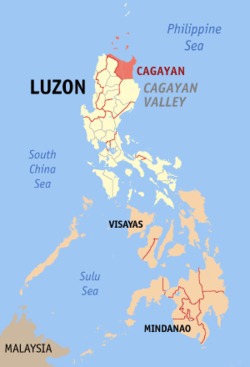
| Region | Cagayan Valley (Region II) | ||
| Founded | 1581 | ||
| Capital | Tuguegarao | ||
| Government | |||
| • Governor | Manuel Mamba (LP) | ||
| • Vice Governor | Boy Vargas (UNA) | ||
| Area[1] | |||
| • Total | 9,295.75 km2 (3,589.11 sq mi) | ||
| Area rank | 5th out of 81 | ||
| Population (2015 census)[2] | |||
| • Total | 1,199,320 | ||
| • Rank | 22nd out of 81 | ||
| • Density | 130/km2 (330/sq mi) | ||
| • Density rank | 63rd out of 81 | ||
| Divisions | |||
| • Independent cities | 0 | ||
| • Component cities | |||
| • Municipalities | |||
| • Barangays | 820 | ||
| • Districts | 1st to 3rd districts of Cagayan | ||
| Time zone | PHT (UTC+8) | ||
| ZIP code | 3500–3528 | ||
| IDD : area code | +63 (0)78 | ||
| ISO 3166 code | PH-CAG | ||
| Spoken languages | |||
| Website |
www | ||

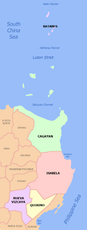
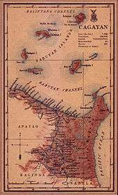
Cagayan (/kɑːɡəˈjɑːn/ kah-gə-YAHN) is a province of the Philippines in the Cagayan Valley region in the northeast of Luzon Island, and includes the Babuyan Islands to the north. The province borders Ilocos Norte and Apayao to the west, and Kalinga and Isabela to the south. Its capital is Tuguegarao.
Cagayan was one of the early provincias that existed during the Spanish Colonial Period. Called La Provincia de Cagayan, its borders essentially covered the entire Cagayan Valley, which included the present provinces of Isabela, Quirino, Nueva Vizcaya, Batanes and portions of Kalinga and Apayao. The former capital was Nueva Segovia, which also served as the seat of the Diocese of Nueva Segovia.[3] Today, only 9,295.75 square kilometres (3,589.11 sq mi)[4] remain of the former vastness of the province. The entire region, however, is still referred to as Cagayan Valley. In 2013, Cagayan was host to the 27th (Survivor: Blood vs. Water) and 28th (Survivor: Cagayan) seasons of the reality television series Survivor (U.S. TV series).
Etymology
Present-day chroniclers hold that the name was originally derived from the tagay, a plant that grows abundantly in the northern part of the province. The term Catagayan, "the place where the tagay grows" was shortened to Cagayan.[3] Perhaps more conventionally, etymological scholars hold that cagayan comes from an ancient word that means "river". Variations of this word—karayan, kayayan, and kalayan—all mean river.[3][5]
History
Pre-colonial period
Cagayan has a prehistoric civilization with rich and diverse culture. According to archaeologists, the earliest man in the Philippines probably lived in Cagayan thousands of years ago. Evidences to this effect are now convincing beyond scientific doubt to consider it as an incontestable fact.
From available evidences, the Atta or Negrito - a short dark-skinned nomad - was the first man in Cagayan. They were later moved to the uplands by the Malays who eventually became the Ibanags, Itawes, Yogads, Gaddangs, Irayas and Malawegs - the natives of Cagayan - who actually came from one ethnicity. These are the people found by the Spaniards in the different villages along the rivers all over Cagayan. The Spaniards rightly judged that these various villagers came from a single racial stock and decided to make the Ibanag language the lingua franca, both civilly and ecclesiastically for the entire people of Cagayan which they called collectively as the Cagayanes which later was transliterated to become Cagayanos.
Even before the Spaniards came to Cagayan, the Cagayanos have already made contact with various civilizations like the Chinese, Japanese and even Indians, as evidenced by various artifacts and even the presence of minor to moderate foreign linguistic elements in the languages of the natives.
Various other racial strains, mainly the Ilocanos, Pangasinenses, Kapampangans and Tagalogs, as well as Visayans, Moros and even foreigners like the Chinese, Japanese, Indians, Arabs, Spaniards and others were further infused to the native Cagayanes to become the modern Cagayano that we know today.
Spanish colonial period
In 1581, Captain Ivan Sabala arrived in Cagayan with a hundred fully equipped soldiers and their families by order of Gonzalo Ronquillo de Peñaloza, the fourth Spanish Governor-General of the Philippines. The expeditionary force was sent to explore the Cagayan Valley, to forcibly convert the natives to Catholicism, and to establish ecclesiastical missions and towns throughout the valley.
On 29 June 1583, Spanish conquistador Juan de Salcedo traced the northern coastline of Luzon and set foot on the Massi (Pamplona), Tular, and Aparri areas.
La Provincia de Cagayan
In 1583, through a Spanish Royal Decree, the entire northeastern portion of Luzon (specifically, all territories east of the Cordillera mountains and those north of the Caraballo mountains) including the islands in the Balintang Channel were organized into one large political unit called the La Provincia de Cagayan. The provincia's territorial delineation encompassed the present provinces of Batanes, Isabela, Quirino, Nueva Vizcaya, including portions of Kalinga and Apayao. Its capital was Nueva Segovia (the present municipality of Lal-lo).[3]
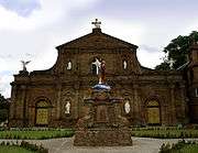
The Spanish friars soon established mission posts in Camalaniugan and Lal-lo (Nueva Segovia), which became the seat of the Diocese established by Pope Clement VIII on August 14, 1595. The see was moved in 1758 to Vigan because of its relative distance. The Spanish influence can still be seen in the massive churches and other buildings that the Spaniards built for the spiritual and social welfare of the people.
In 1839, Nueva Vizcaya was established as a politico-military province and was separated from Cagayan. Later, Isabela was founded as a separate province on May 1, 1856, its areas carved from southern Cagayan and eastern Nueva Vizcaya territories.[3]
During the late 18th century, the New Spain government encouraged the expansion of trade and development of commodity crops. Among these was tobacco, and lands in Cagayan became the center of a vertical integrated monopoly: tobacco was grown there and shipped to Manila, where it was processed and made into cigarettes and cigars. The development of the related bureaucracy and accounting systems was done under the leadership of José de Gálvez, who as visitor-general to Mexico from 1765 to 1772 developed the monopoly there and increased revenues to the Crown. He worked in the Philippines as Minister of the Indies from 1776 to 1787, constructing a similar monopoly there under Governor-General Basco y Vargas (1778–1787).[6] The Spanish development of this industry affected all their economic gains in the Philippines.[6]
The establishment of the civil government of Cagayan through the 1583 Spanish Royal Decree is commemorated in the annual Aggao Nac Cagayan celebrations of the Provincial Government of Cagayan and its people.
American period
When the Treaty of Paris was signed in 1898, ending the Spanish–American War, the United States took over the Philippines. It influenced the culture, most notably in agriculture and education, as well as in public works and communications. A naval base at increased interaction between local Filipinos and American sailors and administrators. At the close of the 18th century, there were 29 municipalities in the province of Cagayan. After the Philippines came under American sovereignty in 1902, more municipalities were founded. Since then, due to centralization and shifting of populations, the number of municipalities is back to 29.
World War II
During the Second World War, with air raids by Japanese fighters and bombers, the province of Cagayan suffered much destruction by bombing and later invasion. Japanese Imperial forces entered Cagayan in 1942. While under the Japanese Occupation, several pre-war infantry divisions and regular units of the Philippine Commonwealth Army were re-established during the period on January 03, 1942 to June 30, 1946. They established general headquarters, camps and garrisoned troops in the province of Cagayan, and began operations against the Japanese Occupation forces in the Cagayan Valley. This included sending troops to the provinces of Cagayan and Isabela, and helping the local soldiers of the 11th and 14th Infantry Regiment of the USAFIP-NL, the local guerrilla fighters and the U.S. liberation forces. They fought against the Japanese Imperial forces from 1942 to 1945.
The Battle of Cape Engaño on October 26, 1944, was held off Cape Engaño. At that time American carrier forces attacked the Japanese Northern Force. This became the concluding action of the Battle of Leyte Gulf. The Japanese lost 4 carriers, 3 light cruisers and 9 destroyers.
In 1945, the combined United States and Philippine Commonwealth ground troops, together with the recognized guerrillas, took Cagayan. Part of the action were the Filipino soldiers of the 1st, 2nd, 11th, 12th, 13th, 15th and 16th Infantry Division of the Philippine Commonwealth Army, 1st Infantry Regiment of the Philippine Constabulary and the 11th and 14th Infantry Regiment of the United States Armed Forces in the Philippines – Northern Luzon or USAFIP-NL from the Battle of Cagayan Valley during the Second World War.
Post-war era
The Hotel Delfino siege was a bloody coup attempt that took place on March 4, 1990, when suspended Cagayan governor Rodolfo Aguinaldo and his armed men of 200 seized Hotel Delfino in Tuguegarao. They held as hostage Brigadier General Oscar Florendo, his driver and four members of the civilian staff, and several other people for several hours. The government launched a gunfight to kill Aguinaldo and his men. Killed in the action was one of Aguinaldo's men, Brig. Gen. Florendo and 12 others, with 10 persons wounded. Aguinaldo was slightly wounded but eventually escaped and hid in the mountains.
Geography
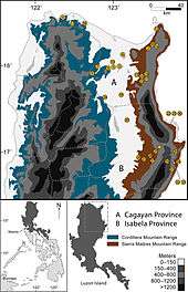
Situated within the Cagayan Valley region, the province is bounded by the Philippine Sea on the east; on the south by Isabela province; on the west by the Cordillera Mountains; and on the north by the Balintang Channel and the Babuyan Group of Islands. About 2 kilometres (1.2 mi) from the northeastern tip of the province is the island of Palaui; a few kilometers to the west is Fuga Island. The Babuyan Group of Islands, which includes Calayan, Dalupiri, Camiguin, and Babuyan Claro, is about 60 nautical miles (110 km) north of Luzon mainland.
The eastern coast forms the northern portion of the Sierra Madre mountain range, while the western limits are generally hilly to low in elevation. The central area, dominated by a large valley, forms the lower basin of the country's longest river, the Cagayan.[3] The mouth is located at the northern town of Aparri.
The province comprises an aggregate land area of 9,295.75 square kilometres (3,589.11 sq mi)[4] which constitutes approximately three percent of the total land area of the country, making it the second largest province in the region.
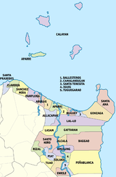
Administrative divisions
Cagayan comprises 28 municipalities and one city divided into three congressional districts. It has 820 barangays. Tuguegarao City (as of December 18, 1999) is the provincial capital, regional seat, and center of business, trade, and education.
- † Provincial capital and component city
- Municipality
| ||||||||||||||||||||||||||||||||||||||||||||||||||||||||||||||||||||||||||||||||||||||||||||||||||||||||||||||||||||||||||||||||||||||||||||||||||||||||||||||||||||||||||||||||||||||||||||||||||||||||||||||||||||||||||||||||||||||||||||||||||||||||||||||||||||||||||||||||||||||||||||||||||||||||||||||||||||||||||||||||||||||||||||||||||||||||||||||||||||||||||||||||||||||||||||||||||||||||||||||||||||||||||||||||||||||
Barangays
The 28 municipalities and 1 city of the province comprise a total of 820 barangays, with Ugac Sur in Tuguegarao City as the most populous in 2010, and Centro 15 (Poblacion) in Aparri as the least. If cities are excluded, Maura in Aparri has the highest population.[7]
Climate
| Climate data for Cagayan | |||||||||||||
|---|---|---|---|---|---|---|---|---|---|---|---|---|---|
| Month | Jan | Feb | Mar | Apr | May | Jun | Jul | Aug | Sep | Oct | Nov | Dec | Year |
| Average high °C (°F) | 27.9 (82.2) |
29.1 (84.4) |
30.9 (87.6) |
32.7 (90.9) |
33.2 (91.8) |
33.8 (92.8) |
33.5 (92.3) |
33.1 (91.6) |
32.6 (90.7) |
31.8 (89.2) |
30.4 (86.7) |
28.3 (82.9) |
31.44 (88.59) |
| Average low °C (°F) | 20.6 (69.1) |
21.8 (71.2) |
22.3 (72.1) |
23.8 (74.8) |
24.7 (76.5) |
24.8 (76.6) |
24.9 (76.8) |
24.6 (76.3) |
24.2 (75.6) |
23.9 (75) |
22.8 (73) |
21.5 (70.7) |
23.33 (73.97) |
| Average rainy days | 8 | 4 | 3 | 2 | 6 | 6 | 7 | 8 | 10 | 9 | 11 | 11 | 85 |
| Source: Storm247[8] | |||||||||||||
Demographics
| Population census of Cagayan | ||
|---|---|---|
| Year | Pop. | ±% p.a. |
| 1990 | 829,867 | — |
| 1995 | 895,050 | +1.43% |
| 2000 | 993,580 | +2.26% |
| 2007 | 1,072,571 | +1.06% |
| 2010 | 1,124,773 | +1.74% |
| 2015 | 1,199,320 | +1.23% |
| Source: National Statistics Office[2][7][7] | ||
The population of Cagayan in the 2015 census was 1,199,320 people,[2] with a density of 130 inhabitants per square kilometre or 340 inhabitants per square mile.
The majority of people living in Cagayan are of Ilocano descent, mostly from migrants coming from the Ilocos Region. Originally, the more numerous group were the Ibanags, who were first sighted by the Spanish explorers and converted to Christianity by missionaries, the reason why the Ibanag language had spread throughout the valley region prior to the arrival of the migrating Ilocanos. Cagayan is predominantly Roman Catholic with 85% of the population affiliated and the Aglipayan Church has a very strong minority in the province.
Aside from Ilocanos and Ibanags, Malaw egs, Itawits, Gaddangs, groups of nomadic Aetas, as well as families of Ibatans who have assimilated into the Ibanag-Ilocano culture make Cagayan their home. More recently, a new group from the south, the Muslim Filipinos, have migrated to this province and have made a community for themselves. In addition to this, Tagalog-speaking peoples from east-Central Luzon (mainly in Aurora, Nueva Ecija and Bulacan) and Southern Luzon have also settled in the area, as well as a few Pangasinenses and Kapampangans from the central plains.
Economy
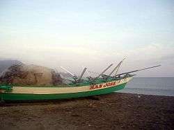
Agricultural products are rice, corn, peanut, beans, and fruits. Livestock products include cattle, hogs, carabaos, and poultry. Fishing various species of fish from the coastal towns is also undertaken. Woodcraft furniture made of hardwood, rattan, bamboo, and other indigenous materials are also available in the province.[3]
The Northern Cagayan International Airport is a planned airport in Lal-lo. The airport will be built to support the Cagayan Special Economic Zone in northern Cagayan, which also serves seaborne traffic through Port Irene. The airport project will involve the construction of a 2,200-meter runway, with a width of 45 meters, following the standards of the International Civil Aviation Organization. Once completed, the planned international airport can accommodate large aircraft such as the Airbus A319-100 and Boeing regional jets of comparable size.[10]
Tourism
Since Cagayan faces the Philippine Sea, an extensive shoreline sprawls along the northern coastal towns of Sanchez Mira, Santa Praxedes, Claveria, Buguey, Aparri, Ballesteros, Abulug, and the islands of Palaui, Fuga, and island municipality of Calayan. Sanchez Mira, Claveria, and Santa Praxedes have facilities for excursion stays while Fuga Island is being developed as a world-class recreation and tourism center. Activities include whale watching at the Calayan Islands, and scuba diving, snorkeling and fishing in Palaui Island of Santa Ana. The airstrip at Claveria could be used as a jump-off point to Fuga Island.
The Sambali Festival is celebrated throughout the province in commemoration of its founding. Hotels include the Governors Garden Hotel, Hotel Candice, Hotel Roma and Hotel Kimikarlai all in Tuguegarao City.
Claveria is host to several scenic attractions which include: the Lakay-Lakay Lagoon, the rocky formation along the Camalaggaon Caves, the Roadside Park overlooking the Claveria Bay, Macatel Falls with its clear waters that run in abundance throughout the year, the Pata Lighthouse, and the Claveria Beach Resort along the white sand coasts.[11]
Notable people from Cagayan
- Juan Ponce Enrile — he served as Justice Secretary and then Defense Secretary under the Marcos regime. He later became one of the leaders (along with General Fidel V. Ramos) of the 1986 People Power Movement that drove Marcos from power. Enrile has continued to be a prominent politician since then; he has been President of the Senate of the Philippines from November 2008 to June 2013.
- Diosdado P. Banatao — entrepreneur and engineer working in the high-tech industry.
- Maja Ross Andres Salvador — a popular actress of ABS-CBN, born and raised in Brgy. Canayun, Abulug, Cagayan.
- Samuel Bagasin — retired general of AFP, former undersecretary of the Dept. of National Defense, from Nagrangtayan, Sanchez Mira, Cagayan.
- Eulogio Baluitan Balao — former Secretary of the Dept. of National Defense and former Senator of the Republic of the Philippines, from Tuguegarao City.
See also
References
- ↑ "List of Provinces". PSGC Interactive. Makati City, Philippines: National Statistical Coordination Board. Archived from the original on 21 January 2013. Retrieved 20 January 2014.
- 1 2 3 4 "Region II (CAGAYAN VALLEY)". Census of Population (2015): Total Population by Province, City, Municipality and Barangay (Report). PSA. Retrieved 20 June 2016.
- 1 2 3 4 5 6 7 Lancion, Jr., Conrado M.; de Guzman, Rey (cartography) (1995). "The Provinces". Fast Facts about Philippine Provinces (The 2000 Millenium ed.). Makati, Metro Manila: Tahanan Books. pp. 48, 49, 84, 118. ISBN 971-630-037-9. Retrieved 16 January 2015.
- 1 2 3 4 "Province: Cagayan". PSA. Philippines: National Statistical Coordination Board. Retrieved 8 January 2016.
- ↑ http://cagayandeoro.elizaga.net/Appendix/meaning-of-cagayan.html Etymology discussion Dr. Lawrence A. Reid, Researcher Emeritus of the Department of Linguistics, University of Hawai'i.
- 1 2 Jane Baxter, Chris Poullaos, Practices, Profession and Pedagogy in Accounting: Essays in Honour of Bill Birkett, Sydney University Press, 2009, pp.152-161
- 1 2 3 4 "Region II (CAGAYAN VALLEY)". Census of Population and Housing (2010): Total Population by Province, City, Municipality and Barangay (Report). NSO. Retrieved 29 June 2016.
- ↑ "Weather forecast for Province of Cagayan, Philippines". Storm247. Retrieved 31 January 2016.
- ↑ Table 4. Household Population by Ethnicity and Sex: Cagayan, 2000
- ↑ Business Mirror: 1B Airport in Cagayan http://www.businessmirror.com.ph/home/regions/15728-p16b-airport-to-be-built-in-cagayan-.html Retrieved November 23, 2011.
- ↑ Paraiso Philippines: Cagayan, retrieved November 23, 2011.
External links
-
 Cagayan travel guide from Wikivoyage
 -
 Media related to Cagayan at Wikimedia Commons
 -
 Geographic data related to Cagayan at OpenStreetMap
 - Official Website of the Provincial Government of Cagayan
- Philippine Standard Geographic Code
 |
Ilocos Norte | Batanes / Balintang Channel (Luzon Strait) |
| |
| Apayao | |
Philippine Sea | ||
| ||||
| | ||||
| Kalinga | Isabela |
Tuguegarao (capital) | |
| Municipalities | |
| Component city | |
| Barangays | |