Sultan Kudarat
For the person, see Muhammad Kudarat.
| Sultan Kudarat | |||
|---|---|---|---|
| Province | |||
| Province of Sultan Kudarat | |||
|
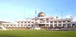
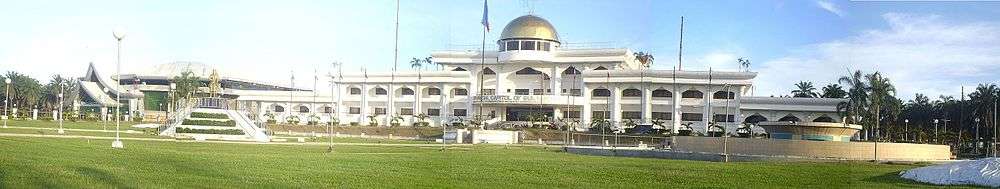
Sultan Kudarat Provincial Capitol | |||
| |||
 Location in the Philippines | |||
| Coordinates: 6°33′N 124°17′E / 6.55°N 124.28°ECoordinates: 6°33′N 124°17′E / 6.55°N 124.28°E | |||
| Country | Philippines | ||
| Region | Soccsksargen (Region XII) | ||
| Founded | November 22, 1973 | ||
| Capital | Isulan | ||
| Government | |||
| • Type | Sangguniang Panlalawigan | ||
| • Governor | Suharto Mangudadatu (Independent) | ||
| • Vice Governor | Ernesto Matias (UNA) | ||
| Area[1] | |||
| • Total | 5,298.34 km2 (2,045.70 sq mi) | ||
| Area rank | 18th out of 81 | ||
| Population (2015 census)[2] | |||
| • Total | 812,095 | ||
| • Rank | 34th out of 81 | ||
| • Density | 150/km2 (400/sq mi) | ||
| • Density rank | 56th out of 81 | ||
| Divisions | |||
| • Independent cities | 0 | ||
| • Component cities |
1
| ||
| • Municipalities | |||
| • Barangays | 249 | ||
| • Districts | 1st and 2nd districts of Sultan Kudarat | ||
| Time zone | PHT (UTC+8) | ||
| ZIP code | 9800–9811 | ||
| IDD : area code | +63 (0)64 | ||
| ISO 3166 code | PH-SUK | ||
| Spoken languages | |||
| Website |
sultankudaratprovince | ||

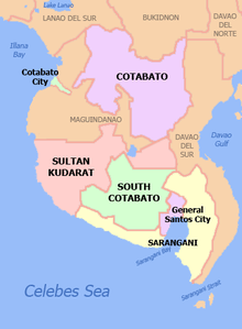
Sultan Kudarat (Hiligaynon: Kapuoran sang Sultan Kudarat; Karay-a: Probinsya kang Sultan Kudarat; Cebuano: Lalawigan sa Sultan Kudarat; Maguindanaoan: Dalapa sa Sultan Kudarat; Ilocano: Probinsiya ti Sultan Kudarat; Filipino: Lalawigan ng Sultan Kudarat) is a province in the Philippines located in the Soccsksargen region in Mindanao. Its capital is Isulan and the commercial center is Tacurong City.
History
Sultan Kudarat was part of the former empire province of Cotabato, until its creation as an independent province (along with Maguindanao and North Cotabato) on November 22, 1973, through Presidential Decree No. 341 signed by President Ferdinand E. Marcos.[3]
The name Sultan Kudarat given to the province was derived from the Muslim ruler, Sultan Muhammad Dipatuan Kudarat who begun to assert his leadership in the year 1619 and reigned in the Sultanate of Maguindanao from 1625 to 1671. He is considered a national hero, and in his honor the province was named after him.[4]
Geography
Sultan Kudarat is situated on the southwestern section of central Mindanao. It is bounded on the north by the provinces of Maguindanao and North Cotabato; on the south by South Cotabato and Sarangani; on the east by Davao del Sur; and on the west by the Moro Gulf and the Celebes Sea. The province's total land area is 5,298.34 square kilometres (2,045.70 sq mi).[5]

Two major mountain ranges encompass the province; the Alip Mountain Range in Columbio and the Daguma Mountain Range within the towns of Bagumbayan, Isulan and Esperanza.[6] The three coastal towns on the province's western side (Lebak, Kalamansig and Palimbang) are lined with mountain ranges that separate the central part of the province from the sea. There are also mountains on the eastern side, leaving flat land in between.[7]
The province has an irregular coastline of 132 kilometres (82 mi) in its three coastal towns, which face the Celebes Sea.[8] These coastal areas are prone to tsunamis coming from the Celebes Sea.[6] Approximately 2/3 of Lake Buluan's area is covered by the province in the towns of Lutayan and President Quirino. There are 7 major rivers within the province: Alip, Allah, Kapingkong, Tran, Salaman, Palimbang and Kabulnan. Additionally, there are 23 large creeks and 11 major springs within the province.[8]
Land use and soil types
Forestland constitutes majority of the province land use (50.32% ), followed by agricultural land (44.77%), fishing grounds (2.42%), non-agricultural land (1.16%), "other bodies of water" (1.02%), and fishponds (0.31%).[9]
Five major soil types are found within the province, majority of which is classified as Mountain Soil (71%), followed by Sandy Loam (12.036%), Silty Clay Loam (4.880%), Clay Loam (4.612%) and Loamy Sand (0.185).[10]
Climate
The climate of Sultan Kudarat falls under Type IV of Climate (characterized by rain showers or evenly distributed rainfall throughout the year). Heavy rainfall occurs from April to November. Unlike most other provinces in the country, Sultan Kudarat is generally free from typhoons as it is situated outside the "typhoon belt".[6]

The average temperature is 35 °C (95 °F), with 38 °C (100 °F) as the average maximum normally occurring in March. The lowest recorded was 18 °C (64 °F) in the Kulaman area in December to early January.[6]
Administrative divisions
Sultan Kudarat comprises 11 municipalities and 1 city. Three of the municipalities (Kalamansig, Lebak, and Palimbang) are coastal towns, while the rest of the province is located inland. The 11 municipalities and Tacurong City are further subdivided into 249 barangays.
Tacurong City is the smallest unit in the province by land area, but is the most urbanized, and is considered the province's commercial center. Other growth centers are Lebak and Isulan, the latter being the provincial capital.
| |||||||||||||||||||||||||||||||||||||||||||||||||||||||||||||||||||||||||||||||||||||||||||||||||||||||||||||||||||||||||||||||||||||||||||||||||||||||||||||||||||||||||||||||||||||||||||||||||||||||||
Demographics
| Population census of Sultan Kudarat | ||
|---|---|---|
| Year | Pop. | ±% p.a. |
| 1990 | 435,905 | — |
| 1995 | 522,187 | +3.44% |
| 2000 | 586,505 | +2.52% |
| 2007 | 675,644 | +1.97% |
| 2010 | 747,087 | +3.73% |
| 2015 | 812,095 | +1.60% |
| Source: National Statistics Office[2][11][11] | ||
The population of Sultan Kudarat in the 2015 census was 812,095 people,[2] with a density of 150 inhabitants per square kilometre or 390 inhabitants per square mile.
At the 2000 census, the province had a total population of 586,505, which grew to 747,087 people in the 2010 census. About 113 ethnic groups were identified in the province in the 2000 Census.[12] The Ilonggos constitute the majority of the Christian population;[12] their native languages are Hiligaynon and Kinaray-a, which are the province's dominant language.[13] Other major languages in the province are the Maguindanao, Ilocano and Cebuano[6]
Aside from the Ilonggos, the major ethnic groups are the Karay-a, Cebuano, Maguindanao, Ilocano, Manobo, Tiruray and the B'laan.[12] Ilocanos are relative newcomers to the province while Ilonggos and Cebuanos inhabited the province around 17th to 18th century.
Religion
According to the 2000 Census, the dominant religion is Christianity, particularly Roman Catholicism, which spread after the Second World War, outnumbering the previously majority Muslim population. The four major religious groups in Sultan Kudarat are Roman Catholicism (55.99%), Islam (22.88), Evangelical (7.20%), and Iglesia Ni Cristo (2.26%).[6] Roman Catholics in the province fall under the jurisdictions of the Roman Catholic Diocese of Kidapawan and Diocese of Marbel, suffragans of Archdiocese of Cotabato. Other Christian groups constitute most of the remainders such as the Seventh-day Adventists, United Church of Christ in the Philippines, Jehovah's Witnesses, United Methodist Church, Southern Baptists, as well as "tribal religions", among others.[14]
Economy

The economy of Sultan Kudarat is predominantly agricultural. The leading crops produced in the province are rice, corn, coconut, coffee, banana, mango, durian and African palm.[15] The province is self-sufficient in poultry, swine, and root crops, and is one of the few producers of Irish potatoes in the Philippines. The southern Philippines Grain Complex in Tacurong is the largest grains-processing complex in the country. There are more than 200 rice mills in the province.
Fishing is an industry in the three coastal towns of the province (Kalamansig, Lebak and Palimbang).[16] Tuna caught along the coasts along the Celebes Sea are exported to Japan and Europe.
Other economic activities include cottage industries, which include crafts made of rattan and other types of wood.
Metallic minerals, which include copper, gold and silver, are found within the mountainous areas of Isulan, Bagumbayan, Sen. Ninoy Aquino, Palimbang and Columbio. Non-metallic minerals which include sand, gravel and marbleized limestone are also found in the province.[17]
Education
For the school year 2009-2010, the province has 475 schools (401 public and 74 private), 368 of which were elementary schools, 90 were secondary, and 17 were tertiary. Sultan Kudarat State University is the only public tertiary school within the province, with its main campus at Tacurong City. Its other campuses are situated in Bagumbayan, Isulan, Kalamansig, Lutayan, Palimbang, and Senator Ninoy Aquino.[18]
Health facilities
In 2010, Sultan Kudarat had 27 hospitals (5 government-owned, 22 private and 1 mobile hospital), which are classified into 17 primary (6-25 beds capacity), 8 secondary (25-100 beds capacity) and 2 tertiary (over 100 beds capacity). Tacurong had the most number of hospitals in the province with 11, followed by Isulan with 5.[19]
Transportation
As of 2010, the provincial road network spanned a total length of 3,749.5813 kilometres (2,329.8818 mi) of which 49.26% were barangay roads, 27.97% provincial roads, 13.51% municipal/city roads and 9.25% national roads. Bagumbayan had the longest road network at 516.789 kilometres (321.118 mi), while Lutayan had the shortest at 107.38 kilometres (66.72 mi).[18]
Sultan Kudarat has two seaports: the Port of Lebak in Kalamansig and the San Roque Port in Palimbang, and four airports (2 government-owned: Lebak Municipal Airport and President Quirino Airport, and 2 privately-owned: Kalamansig Airport and Kenram Airport).[20]
Government
|
|
The former governors who have administered the province are:[21]
- Carlos B. Cajelo (Acting Governor) (November 23, 1973 — February 28, 1974)
- Gonzalo H. Siongco (Acting Governor) (March 1, 1974 — October 20, 1975)
- Conrado E. Buencamino (assumed as Governor) (October 21, 1975 — November 21, 1975)
- Benjamin C. Duque (Acting Governor) (November 22, 1975 — December 31, 1979); was elected Governor (January 1, 1980 — June 30, 1984)
- Aurelio C. Freires, Jr. (July 1, 1984 — March 19, 1986)
- Perfecto C. Bautista (assumed as Officer-In-Charge of the province) (March 20, 1986 — November 30, 1987)
- Fidel A. Fortez (designated as Officer-In-Charge) (December 1, 1987 — December 22, 1987)
- Exequiel S. Mayordomo (appointed as Officer-In-Charge) (December 23, 1987 — July 12, 1988)
- Nesthur R. Gumana (elected Provincial Governor) (July 13, 1988 — March 25, 1998)
- Rosila P. Jamison (March 26 — June 30, 1998)
- Pax S. Mangudadatu (July 1, 1998 — June 30, 2007)
- Suharto T. Mangudadatu (July 1, 2007 — present)
Festivals
Festivals celebrated within the province include:
- Kalimudan — celebrated in the province of Sultan Kudarat, a gathering of ethnic groups within the province[22]
- Bansadayaw — celebrated in Bagumbayan[23]
- Kastifun — celebrated in Columbio[24]
- Hinabyog — celebrated in Esperanza[25]
- Pasundayag — celebrated in Isulan[26]
- Salgaan — celebrated in Kalamansig[27]
- Timpuyog — celebrated in Lambayong[28]
- Hinugyaw — celebrated in Lebak[29]
- Kanduli — celebrated in Lutayan[30]
- Kalilang — celebrated in Palimbang[31]
- Sambuyawan — celebrated in President Quirino[32]
- Sulok — celebrated in Senator Ninoy Aquino[33]
- Talakudong — celebrated in Tacurong City[34]
Citations
- ↑ "List of Provinces". PSGC Interactive. Makati City, Philippines: National Statistical Coordination Board. Retrieved 27 May 2014.
- 1 2 3 4 "Region XII (SOCCSKSARGEN)". Census of Population (2015): Total Population by Province, City, Municipality and Barangay (Report). PSA. Retrieved 20 June 2016.
- ↑ "Presidential Decree No. 341: Creating the Provinces of North Cotabato, Maguindanao and Sultan Kudarat". Philippine Laws, Statutes & Codes. Chan Robles Virtual Law Library. 22 November 1973. Retrieved 27 May 2014.
- ↑ Socio-Economic Profile of Sultan-Kudarat 2010, p. 1.
- 1 2 3 "Province: Sultan Kudarat". PSA. Philippines: National Statistical Coordination Board. Retrieved 8 January 2016.
- 1 2 3 4 5 6 Socio-Economic Profile of Sultan-Kudarat 2010, p. 8.
- ↑ Socio-Economic Profile of Sultan-Kudarat 2010, p. 5.
- 1 2 Socio-Economic Profile of Sultan-Kudarat 2010, p. 6.
- ↑ Socio-Economic Profile of Sultan-Kudarat 2010, p. 34.
- ↑ Socio-Economic Profile of Sultan-Kudarat 2010, pp. 35-36.
- 1 2 3 "Region XII (SOCCSKSARGEN)". Census of Population and Housing (2010): Total Population by Province, City, Municipality and Barangay (Report). NSO. Retrieved 29 June 2016.
- 1 2 3 Socio-Economic Profile of Sultan-Kudarat 2010, p. 11.
- ↑ Socio-Economic Profile of Sultan-Kudarat 2010, p. 9.
- ↑ Socio-Economic Profile of Sultan-Kudarat 2010, pp. 10-11.
- ↑ Socio-Economic Profile of Sultan-Kudarat 2010, pp. 56-62.
- ↑ Socio-Economic Profile of Sultan-Kudarat 2010, p. 48.
- ↑ Socio-Economic Profile of Sultan-Kudarat 2010, p. 42.
- 1 2 Socio-Economic Profile of Sultan-Kudarat 2010, p. 74.
- ↑ Socio-Economic Profile of Sultan-Kudarat 2010, p. 86.
- ↑ Socio-Economic Profile of Sultan-Kudarat 2010, p. 129.
- ↑ Socio-Economic Profile of Sultan-Kudarat 2010, pp. 1-2.
- ↑ Socio-Economic Profile of Sultan-Kudarat 2010, p. 220.
- ↑ Socio-Economic Profile of Sultan-Kudarat 2010, p. 221.
- ↑ Socio-Economic Profile of Sultan-Kudarat 2010, p. 222.
- ↑ Socio-Economic Profile of Sultan-Kudarat 2010, p. 223.
- ↑ Socio-Economic Profile of Sultan-Kudarat 2010, p. 224.
- ↑ Socio-Economic Profile of Sultan-Kudarat 2010, p. 225.
- ↑ Socio-Economic Profile of Sultan-Kudarat 2010, p. 226.
- ↑ Socio-Economic Profile of Sultan-Kudarat 2010, p. 227.
- ↑ Socio-Economic Profile of Sultan-Kudarat 2010, p. 228.
- ↑ Socio-Economic Profile of Sultan-Kudarat 2010, p. 229.
- ↑ Socio-Economic Profile of Sultan-Kudarat 2010, p. 230.
- ↑ Socio-Economic Profile of Sultan-Kudarat 2010, p. 231.
- ↑ Socio-Economic Profile of Sultan-Kudarat 2010, p. 232.
References
- "2010 Socio-Economic Profile; Sultan Kudarat Province" (PDF). Province of Sultan Kudarat. PPDO Staff. 2010. Retrieved 24 April 2016.
External links
-
 Media related to Sultan Kudarat at Wikimedia Commons
 -
 Geographic data related to Sultan Kudarat at OpenStreetMap
 - Official website of the provincial government of Sultan Kudarat
- Local Governance Performance Management System
- Manila Statues: Sultan Kudarat Monument Information
 |
Maguindanao | Cotabato | | |
| Celebes Sea | |
Davao del Sur | ||
| ||||
| | ||||
| Sarangani / South Cotabato |
Isulan (capital) | |
| Municipalities | |
| Component city | |