Zamboanga del Sur
| Zamboanga del Sur | |||
|---|---|---|---|
| Province | |||
| Province of Zamboanga del Sur | |||
| |||
 Location in the Philippines | |||
| Coordinates: 7°50′N 123°15′E / 7.83°N 123.25°ECoordinates: 7°50′N 123°15′E / 7.83°N 123.25°E | |||
| Country | Philippines | ||
| Region | Zamboanga Peninsula (Region IX) | ||
| Founded | June 6, 1952 | ||
| Capital | Pagadian | ||
| Government | |||
| • Type | Sangguniang Panlalawigan | ||
| • Governor | Antonio Cerilles (NPC) | ||
| • Vice Governor | Juan Regala (NPC) | ||
| Area[1] | |||
| • Total | 4,499.46 km2 (1,737.25 sq mi) | ||
| Area rank | 25th out of 81 | ||
| (excluding Zamboanga City) | |||
| Population (2015 census)[2] | |||
| • Total | 1,010,674 | ||
| • Rank | 27th out of 81 | ||
| • Density | 220/km2 (580/sq mi) | ||
| • Density rank | 42nd out of 81 | ||
| (excluding Zamboanga City) | |||
| Divisions | |||
| • Independent cities | |||
| • Component cities |
1
| ||
| • Municipalities | |||
| • Barangays |
| ||
| • Districts | 1st and 2nd districts of Zamboanga del Sur | ||
| Time zone | PHT (UTC+8) | ||
| ZIP code | 7000–7043 | ||
| IDD : area code | +63 (0)62 | ||
| ISO 3166 code | PH-ZAS | ||
| Spoken languages | |||
| Website |
www | ||


Zamboanga del Sur (Cebuano: Habagatang Zamboanga; Zamboangueño:Provincia de Zamboanga del Sur; Subanen: S'helatan Sembwangan/Sembwangan dapit Shelatan) is a province in the Philippines located in the Zamboanga Peninsula region in Mindanao. Its capital is the city of Pagadian. Grouped with Zamboanga del Sur is the highly urbanized city of Zamboanga, which is governed independently from the province.
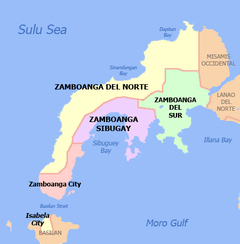
The province borders Zamboanga del Norte to the north, Zamboanga Sibugay to the west, Misamis Occidental to the northeast, and Lanao del Norte to the east. To the south is the Moro Gulf.
History
The name of Zamboanga is the Hispanicized spelling of the Sinama term for "mooring place" - samboangan (also spelled sambuangan; and in Subanen, sembwangan), from the root word samboang ("mooring pole"). "Samboangan" was the original name of Zamboanga City, from where the name of the peninsula is derived from.[3] "Samboangan" is well-attested in Spanish,[4] British,[5][6] French,[7][8] German,[9] and American[10] historical records from as far back as the 17th century.[4]
This is commonly contested by folk etymologies which instead attribute the name of Zamboanga to the Indonesian word jambangan (claimed to mean "place of flowers", but actually means "pot" or "bowl"), usually with claims that all ethnic groups in Zamboanga were "Malays". However, this name has never been attested in any historical records prior to the 1960s.[11]
The original inhabitants of the Zamboanga peninsula were the Subanen, who settled along the riverbanks in inland areas; and the various Sama-Bajau and Yakan ethnic groups who settled in coastal areas. Tausūg settlers from northeastern Mindanao also migrated to the region in the 13th century.[12][13][14]
The region was additionally settled by migrants (mostly from the Visayas islands) after World War II.[15] Together with the original settlers, these pioneers helped develop Zamboanga del Sur into the abundant and culturally diverse province that it is.
Historically, Zamboanga was the capital of the Moro Province in western Mindanao, which comprised five districts: Cotabato, Davao, Sulu, Lanao, and Zamboanga. In 1940, these districts became individual provinces. Zamboanga City became the capital of Zamboanga province. Soon after World War II, the provincial capital was transferred to Dipolog. Molave was created as the provincial capital in 1948.
On June 6, 1952, through Republic Act 711, Zamboanga del Sur was carved out from the former Zamboanga province that encompassed the entire peninsula in southwestern Mindanao.[16] As the 52nd province of the Philippines, it originally consisted of 11 towns, which were later expanded into 42 municipalities and one city, Pagadian, its capital.
Political developments in February 2001 saw another major change in the territorial jurisdiction of Zamboanga del Sur. Its inhabitants voted to create a new province out of the third congressional district, named Zamboanga Sibugay.[17]
Geography
Zamboanga del Sur covers a total area of 4,499.46 square kilometres (1,737.25 sq mi)[18] occupying the southern section of the Zamboanga peninsula in western Mindanao. It is located at longitude 122° 30"" and latitude 7° 15"" north. When Zamboanga City is included for statistical purposes, the province's land area is 591,416 hectares (5,914.16 km2).[18] The province is bordered on the north by Zamboanga del Norte, west by Zamboanga Sibugay, northeast by Misamis Occidental, east by Lanao del Norte, southeast by the Illana Bay, and south by the Moro Gulf.
Topography

Stretching northward from Sibugay in the southwest and running along the northern boundary to Salug Valley in the east is the province’s mountainous countryside. The coastal plains extend regularly from south to west then spread into wide flat lands when reaching the coastal plains of the Baganian peninsula in the southeast.
The longest river in Region IX, the Sibugay River gets its water from the mountains of Zamboanga del Sur most specifically in Bayog and Lakewood, from where it flows into Sibuguey Bay which is now part of Zamboanga Sibugay. Other notable rivers are the Kumalarang River, the Dinas River with its headwaters in the Mount Timolan Protected Landscape, and Salug River in Molave.
Climate
The province has a relatively high mean annual rainfall: 1,599 to 3,500 millimetres (63.0 to 137.8 in). Temperature is relatively warm and constant throughout the year: 22 to 35 °C (72 to 95 °F).
| Climate data for Zamboanga del Sur | |||||||||||||
|---|---|---|---|---|---|---|---|---|---|---|---|---|---|
| Month | Jan | Feb | Mar | Apr | May | Jun | Jul | Aug | Sep | Oct | Nov | Dec | Year |
| Average high °C (°F) | 30.4 (86.7) |
30.5 (86.9) |
31.6 (88.9) |
32.6 (90.7) |
32.3 (90.1) |
31.7 (89.1) |
31.6 (88.9) |
31.6 (88.9) |
31.8 (89.2) |
31.5 (88.7) |
31.4 (88.5) |
30.8 (87.4) |
31.48 (88.67) |
| Average low °C (°F) | 21.8 (71.2) |
21.9 (71.4) |
20.8 (69.4) |
22.2 (72) |
21.2 (70.2) |
21.0 (69.8) |
21.1 (70) |
21.0 (69.8) |
21.1 (70) |
21.3 (70.3) |
21.4 (70.5) |
21.3 (70.3) |
21.34 (70.41) |
| Average rainy days | 15 | 10 | 8 | 7 | 10 | 17 | 16 | 16 | 14 | 16 | 17 | 16 | 162 |
| Source: Storm247 [19] | |||||||||||||

Administrative divisions
Zamboanga del Sur comprises 26 municipalities and 1 component city, organized into two congressional districts and further subdivided into 681 barangays.
Traditionally grouped with Zamboanga del Sur is the highly urbanized city of Zamboanga, which is administratively independent from the province.
| |||||||||||||||||||||||||||||||||||||||||||||||||||||||||||||||||||||||||||||||||||||||||||||||||||||||||||||||||||||||||||||||||||||||||||||||||||||||||||||||||||||||||||||||||||||||||||||||||||||||||||||||||||||||||||||||||||||||||||||||||||||||||||||||||||||||||||||||||||||||||||||||||||||||||||||||||||||||||||||||||||||||||||||||||||||||||||||||||||||||||||||||||||||||||||||||||||||||||||||||||||||||||
Demographics
| Population census of Zamboanga del Sur | ||
|---|---|---|
| Year | Pop. | ±% p.a. |
| 1990 | 695,741 | — |
| 1995 | 766,918 | +1.84% |
| 2000 | 836,217 | +1.87% |
| 2007 | 914,278 | +1.24% |
| 2010 | 959,685 | +1.78% |
| 2015 | 1,010,674 | +0.99% |
| (excluding Zamboanga City) Source: National Statistics Office[2][20][20] | ||
The population of Zamboanga del Sur in the 2015 census was 1,010,674 people,[2] with a density of 220 inhabitants per square kilometre or 570 inhabitants per square mile. When Zamboanga City is included for geographical purposes, the province's population is 1,872,473 people, with a density of 317/km2 (820/sq mi).
Religion
Islam is the largest religion with about 45% percent of the population adherence while Roman Catholicism is an important minority religion. Christian minorities are represented by Baptists, Methodists, Aglipayans, Church of Christ of Latter Day Saints, Iglesia Ni Cristo, Jehovah's Witnesses, Seventh-day Adventist and other Evangelical Christians.
Languages
The most commonly spoken language is Cebuano. Also spoken, although in small percentage, are Zamboangueño, Subanen, Hiligaynon, Maguindanao, Iranun, and Ilocano.
Economy

The economy is predominantly agricultural. Products include coco oil, livestock feed milling, rice/corn milling, including the processing of fruits, gifts and housewares made from indigenous materials like handmade paper, roots, rattan, buri, and bamboo; wood-based manufacture of furniture and furniture components from wood, rattan, and bamboo; marine and aquaculture including support services; construction services and manufacture of marble, concrete, and wooden construction materials. There are also mining areas in the province, such as those found in the municipality of Bayog managed by TVI, a Canadian-based mining firm which concentrates on gold mining, and the Cebu Ore Mining which is handling the Ore-Copper-Steel mines. There are also small-scale mines in the municipality of Dumingag.
Governors
References
- ↑ "List of Provinces". PSGC Interactive. Makati City, Philippines: National Statistical Coordination Board. Archived from the original on January 21, 2013. Retrieved 16 July 2014.
- 1 2 3 4 "Region IX (ZAMBOANGA PENINSULA)". Census of Population (2015): Total Population by Province, City, Municipality and Barangay (Report). PSA. Retrieved 20 June 2016.
- ↑ Rodney C. Jubilado; Hanafi Hussin & Maria Khristina Manueli (2011). "The Sama-Bajaus of Sulu-Sulawesi Seas: perspectives from linguistics and culture" (PDF). Journal of Southeast Asian Studies. 15 (1): 83–95.
- 1 2 Francisco Combes (1667). Historia de las islas de Mindanao, Iolo y sus Adyacentes. Progresos de la Religion y Armas Catolicas. Pablo del Val.
- ↑ Challenger Expedition 1872-1876 (1895). Report on the Scientific Results of the Voyage of H.M.S. Challenger During the Years 1873-76 Under the Command of Captain George S. Nares ... and the Late Captain Frank Tourle Thomson, R.N. H.M. Stationery Office. p. 823–828.
- ↑ George Newenham Wright (1837). A New and Comprehensive Gazetteer, Volume 4. T. Kelly. p. 459.
- ↑ Antoine-François Prévost (1757). Histoire générale des voyages ou Nouvelle collection de toutes les relations de voyages par mer et par terre, qui ont été publiées jusqu'à présent dans les differentes langues de toutes les nations connues. De Hondt. p. 37.
- ↑ Pierre Joseph André Roubaud (1770). Histoire générale de l'Asie, de l'Afrique et de l'Amérique. Des Ventes de la Doué. p. 499–500.
- ↑ John Meares (1791). Des Kapitians John Meares und des Kapitains William Douglas Reisen nach der Nordwest-Küste von Amerika, in den Jahren 1786 bis 1789. Voß. p. 240.
- ↑ Charles Pickering (1848). "The Races of Man and their Geographical Distribution". United States Exploring Expedition. During the Years 1838, 1839, 1840, 1841, 1842. Under the Command of Charles Wilkes, USN. Volume IX (PDF). C. Sherman. p. 125.
- ↑ Enriquez, A.R. "Jambangan: the "Garden of Flowers" never was!". Antoniofermin's Name. Retrieved 13 September 2016.
- ↑ Alfred Kemp Pallasen (1985). Culture Contact and Language Convergence (PDF). LSP Special Monogaph Issue 24. Linguistic Society of the Philippines.
- ↑ Tom Gunnar Hoogervorst (2012). "Ethnicity and aquatic lifestyles: exploring Southeast Asia's past and present seascapes" (PDF). Water History. 4: 245–265. doi:10.1007/s12685-012-0060-0.
- ↑ Rodney C. Jubilado (2010). "On cultural fluidity: The Sama-Bajau of the Sulu-Sulawesi Seas". Kunapipi. 32 (1): 89–101.
- ↑ Wernstedt, Frederick L.; Simkins, Paul D. (1965). "Migrations and the Settlement of Mindanao". The Journal of Asian Studies. 25 (1): 83–103. doi:10.2307/2051042.
- ↑ "Republic Act No. 711 - An Act to Create the Provinces of Zamboanga del Norte and Zamboanga del Sur". Chan Robles Virtual Law Library. Retrieved 28 September 2013.
- ↑ "Republic Act No. 8973; An Act Creating the Province of Zamboanga Sibugay from the Province of Zamboanga del Sur and for Other Purposes" (PDF). House of Representatives of the Philippines. Retrieved 13 January 2016.
- 1 2 3 4 "Province: Zamboanga del Sur". PSGC Interactive. Quezon City, Philippines: Philippine Statistics Authority. Retrieved 8 January 2016.
- ↑ "Weather forecast for Zamboanga del Sur, Philippines". Storm247. Retrieved 20 April 2016.
- 1 2 3 "Region IX (ZAMBOANGA PENINSULA)". Census of Population and Housing (2010): Total Population by Province, City, Municipality and Barangay (Report). NSO. Retrieved 29 June 2016.
External links
-
 Media related to Zamboanga del Sur at Wikimedia Commons
 -
 Geographic data related to Zamboanga del Sur at OpenStreetMap
 - Official website of Zamboanga del Sur
- Daily Zamboanga Times
 |
Zamboanga del Norte | Misamis Occidental | | |
| Zamboanga Sibugay | |
Lanao del Norte | ||
| ||||
| | ||||
| Moro Gulf | Illana Bay |
Pagadian (capital) | |
| Municipalities | |
| Component city | |
| Highly urbanized city |
|