Lanao del Sur


Lanao del Sur (Maranao: Ranao Masarik, Cebuano: Habagatang Lanaw; Filipino: Timog Lanaw), officially the Province of Lanao del Sur, is a province in the Philippines located in the Autonomous Region in Muslim Mindanao (ARMM). The capital is the city of Marawi, and it borders Lanao del Norte to the north, Bukidnon to the east, and Maguindanao and Cotabato to the south. To the southwest lies Illana Bay, an arm of the Moro Gulf.
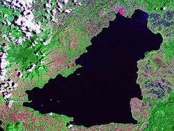
Situated in the interior of Lanao del Sur is Lanao Lake, the largest in Mindanao. The Darangen Epic Chants of the Maranao of Lanao del Sur is inscribed as a UNESCO Intangible Cultural Heritage since 2008.[3]
Etymology
"Lanao" means "lake", derived from ranao. The province, situated at basin of Lake Lanao, is known as the land of the "Maranaos" (which means "the "people of the lake").[4]
History
Sultanate of Lanao
Lanao was first explored by the Spaniards in 1689, upon which they discovered a well-settled community named Dansalan at the lake's northern end. Lanao was the seat of the Sultanate of Lanao.[4]
During the Pre-Spanish time, there are 4 important boundaries hold the power of appointing a new sultan namely: Bakayawan, Dalama, Madamba and Sawer. In appointing a new sultan the permission of these four boundaries are needed to validate the new sultan appointed to his position.
World War II
In 1942, it was occupied by the Japanese Imperial Forces who landed in Southern Lanao. On May 2, 1942, the former Chief Justice of the Supreme Court of the Philippines Jose Abad Santos was killed by the Japanese Imperial forces in a firing squad at Malabang, Lanao del Sur. In 1945, the first of the liberation forces landed in Southern Lanao and liberated the area with United States, Philippine Commonwealth troops together with the Maranao guerrilla units. They used infantry weapons, the Maranao Kris, Barong and Kampilan swords against the Japanese forces in the Battle of Lanao.
In 1956, Republic Act No. 1552 changed the name Dansalan to Marawi, taken from the word rawi, referring to the reclining lilies abundant in the Agus River.[5]

Division
In 1959, Lanao was divided into two provinces, Lanao del Norte and Lanao del Sur, under Republic Act No. 2228. Marawi was designated as the capital of Lanao del Sur.[6] The city was renamed the "Islamic City of Marawi" in 1980, and is currently the Philippines' only city having a predominantly Muslim population.[4]
Proposed Maranaw province
In 1971, Republic Act No. 6406, which sought to create a new province out of eastern Lanao del Sur (now corresponding to the province's first congressional district), was approved on October 4, 1971. The province was to consist of the municipalities of Bubong, Ditsaan-Ramain (including what is now Buadiposo-Buntong), Kapai, Lumba-Bayabao (including what is now Maguing), Marantao, Masiu, Mulondo, Saguiaran, Piagapo, Poona Bayabao, Tamparan, Taraka and Wao (including what is now Bumbaran), with the chartered city of Marawi serving as the new provincial capital.[7] The division never took place due to the declaration of Martial law in the Philippines on September 21, 1972, which disrupted the elections for 1973.
Joining the ARMM
In a 1989 plebiscite, Lanao del Sur voted to join the Autonomous Region of Muslim Mindanao (ARMM), but Marawi City elected to remain outside ARMM.[4] It later joined ARMM in 2001 following the plebiscite that sought to expand the autonomous region.
Geography
Lanao del Sur forms the western portion of Northern Mindanao. It is bounded on the north by Lanao del Norte, on the east by Bukidnon, on the west by Illana Bay, and on the south by Maguindanao and Cotabato. The landscape is dominated by rolling hills and valleys, placid lakes and rivers.
Located within the province is Lanao Lake, the second largest in the country, its waters drained by the Agus River which eventually empties into the Iligan Bay.[4]
The climate in the province is characterized by even distribution of rainfall throughout the year, without a distinct summer season. The province is located outside the typhoon belt.[4]
Administrative divisions
Lanao del Sur comprises 39 municipalities and 1 city.
- † Provincial capital and component city
- Municipality
| |||||||||||||||||||||||||||||||||||||||||||||||||||||||||||||||||||||||||||||||||||||||||||||||||||||||||||||||||||||||||||||||||||||||||||||||||||||||||||||||||||||||||||||||||||||||||||||||||||||||||||||||||||||||||||||||||||||||||||||||||||||||||||||||||||||||||||||||||||||||||||||||||||||||||||||||||||||||||||||||||||||||||||||||||||||||||||||||||||||||||||||||||||||||||||||||||||||||||||||||||||||||||||||||||||||||||||||||||||||||||||||||||||||||||||||||||||||||||||||||||||||||||||||||||||||||||||||||||||||||||||||||||||||||||||||||||||||||||||||||||||||
Politics
The politics in the province was dominated by few and prestigious families. But only two (2) families have brought big influence in the province the Dimaporo and Alonto families. Both families have produced Governors, Congressmen, Board Members and Mayors, they were considered the most unforgettable political family in the province. The Dimaporos came from a small yet progressive town of Binidayan, Governor Sultan Ali Dimaporo became Governor of the province nominating by late Governor General Mamarinta B. Lao AFP, with the help of his siblings and cousin, Congressman Datu Macacuna Dimaporo, Mayor Sultan Naga Dimaporo of SND and Mayor Sultan Muliloda Datumulok of Binidayan. They once dominated the politics of Lanao. The Family was very known to be an ally of Former President Ferdinand Marcos, they've produced some influential leaders in Lanao del Norte and Lanao del Sur some of them were Congerssman Abdullah Dimaporo of Lanao del Norte, Governor Khalid Dimaporo, Congresswoman Imelda Dimaporo, Former Mayor Motalib Dimaporo of SND, Mayor Eleanor Dimaporo-Lantud, Former Mayor Raida Dimaporo-Papandayan of Tubaran, Former Mayor Abdul Rashid Dimaporo of Magsaysay, Former Board Member Danny Dimaporo, Former Assemblyman Ismael Camid, Former Mayor Punudarano Datumulok of Binidayan, Former Mayor Anwar Datumulok of Pagayawan, Secretary Dimnatang Radia of CDA-ARMM, Former Mayor Halim Datumulok, Former Mayor Sarip Datumulok, Former Mayor Misbak Datumulok and Colaw Datumulok.
On the other hand, the Alonto-Adiong, came from Ramain was headed by Senator Alauya Alonto Adiong with help of his family members, like Mayor Birua Alonto of Marawi had produced Senator, Governors and Congressmen. Upon the Death of Senator Sultan Alauya Alonto, His son, Senator Ahmad Domocao Alonto lead his family with Governor Abdul Ghaffur Alonto they successfully controlled the politics in Lanao del Sur and also produced influential leaders in the province: Governor Princess Tarhata Alonto-Lucman, Congressman Rashid Lucman Governor Mamintal Adiong, Former ARMM-RLA Speaker Abul Khayr Alonto, Former Vice Governor Normala Alonto Lucman, Governor Mamintal Alonto Adiong Jr., Late Mayor Lacsasa Adiong of Ditsaan-Ramain, Congressman Pangalian M.Balindong, Mayor Jamal Alonto of Bubong, Congressman Ansaruddin Alonto Adiong, Former Mayor Ricky Alonto Mamainte of Bayang, Assemblyman Zia Alonto Adiong, Assemblyman Yasser Alonto Balindong, Mayor Ali Adiong of Ditsaan-Ramain, Board Member Alexander G. Alonto, Jr.,Board Member Abdulrashid Alonto Balindong and ARMM Regional Vice-Governor Haroun Al-Rashid Alonto Lucman.
Demographics
| Population census of Lanao del Sur | ||
|---|---|---|
| Year | Pop. | ±% p.a. |
| 1990 | 599,982 | — |
| 1995 | 686,193 | +2.55% |
| 2000 | 800,162 | +3.35% |
| 2007 | 1,138,544 | +4.98% |
| 2010 | 933,260 | −6.98% |
| 2015 | 1,045,429 | +2.18% |
| Source: Philippine Statistics Authority[2][9][10] | ||
The population of Lanao del Sur in the 2015 census was 1,045,429 people,[2] with a density of 270 inhabitants per square kilometre or 700 inhabitants per square mile.
The majority of people in the province are Maranaos,[4] with some and Cebuanos, Chabacanos, Tausugs, Yakan, and Sama-Bajau.
Maranao is the most commonly spoken language in the province.[4] Also spoken are Filipino, Cebuano and Chavacano, followed by English and Arabic.
Religion
The people of Lanao del Sur are predominantly practitioners of Islam,[4] majority of them are Sunnites, with a minority of Christians (mostly Roman Catholics and most of them are Cebuanos and Chabacanos). Roman Catholics of Lanao del Sur fall under the jurisdiction of Territorial Prelature of Marawi, a suffragan of Archdiocese of Ozamiz.
Schools/universities
- Dansalan College
- Gandamatu Private Hospital, located in Macadar (Patka Apo)
- Lanao Agricultural College (LAC), located in Lumbatan
- Mindanao State University (Main Campus)
Hospitals
- Amai Pakpak Medical Center
- Former Libyan Hospital
References
- ↑ Autonomous Region in Muslim Mindanao, Department of Agriculture: Lanao del Sur (There are major discrepancies among authoritative sources: 4121.3 km² (NAMRIA); 1,349,437 ha (NSCB, this value seems unreasonable and must be assumed as erroneous, see Talk:Lanao del Sur#Area))
- 1 2 3 4 Census of Population (2015): Highlights of the Philippine Population 2015 Census of Population (Report). PSA. Retrieved 20 June 2016.
- ↑ "Darangen Epic of the Maranao People of Lake Lanao". United Nations Educational, Scientific and Cultural Organization (UNESCO). 2005. Retrieved 25 December 2015.
- 1 2 3 4 5 6 7 8 9 Lancion, Jr., Conrado M.; cartography by de Guzman, Rey (1995). "The Provinces; Lanao del Sur". Fast Facts about Philippine Provinces (The 2000 Millenium ed.). Makati, Metro Manila, Philippines: Tahanan Books. pp. 94–95. ISBN 971-630-037-9. Retrieved 25 December 2015.
- ↑ "Republic Act No. 1552 - An Act to Amend the Charter of the City of Dansalan So as to Change Its Name to Marawi and Make Elective Its Mayor, Vice-mayor and Councilors, and for Other Purposes". Chan Robles Virtual Law Library. Retrieved 25 December 2015.
- ↑ "Republic Act No. 2228 - An Act to Create the Provinces of Lanao del Norte and Lanao del Sur". Chan Robles Virtual Law Library. Retrieved 25 December 2015.
- ↑ "Republic Act No. 6406 - An Act Dividing the Province of Lanao del Sur into the Province of Maranaw and Lanao del Sur". Chan Robles Virtual Law Library. Retrieved 25 December 2015.
- 1 2 "Province: Lanao del Sur". PSGC Interactive. Quezon City, Philippines: Philippine Statistics Authority. Retrieved 8 January 2016.
- 1 2 Census of Population and Housing (2010): Population and Annual Growth Rates for The Philippines and Its Regions, Provinces, and Highly Urbanized Cities (PDF) (Report). NSO. Retrieved 29 June 2016.
- ↑ "ARMM - Autonomous Region in Muslim Mindanao". Census of Population and Housing (2010): Total Population by Province, City, Municipality and Barangay (Report). NSO. Retrieved 29 June 2016.
External links
-
 Media related to Lanao del Sur at Wikimedia Commons
 -
 Geographic data related to Lanao del Sur at OpenStreetMap
 - Philippine Census Information
- Local Governance Performance Management System
 |
Lanao del Norte | | ||
| Lanao del Norte | |
Bukidnon | ||
| ||||
| | ||||
| Illana Bay (Moro Gulf) | Maguindanao | Cotabato |
Marawi (capital) | |
| Municipalities |
|
| Component city | |
| |||||||||||||||||||||||||||||||||||||||||||||||||||||||||||||||||||||||||||||||||||||||||||||||||||||||||||||||||||||||||||||||||||||||||||||||||||||||||


