Surigao del Sur
| Surigao del Sur | |||
|---|---|---|---|
| Province | |||
| Province of Surigao del Sur | |||
|
Surigao del Sur Provincial Capitol in Tandag | |||
| |||
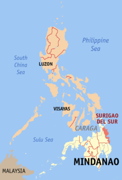 Location in the Philippines | |||
| Coordinates: 8°40′N 126°00′E / 8.67°N 126°ECoordinates: 8°40′N 126°00′E / 8.67°N 126°E | |||
| Country | Philippines | ||
| Region | Caraga (Region XIII) | ||
| Founded | June 19, 1960 | ||
| Capital | Tandag | ||
| Government | |||
| • Type | Sangguniang Panlalawigan | ||
| • Governor | Vicente T. Pimentel, Jr. (Liberal Party) | ||
| • Vice Governor | Manuel O. Alameda, Sr. (Liberal Party) | ||
| • Congressman 1st District | Prospero Pichay, Jr. (Lakas–CMD) | ||
| • Congressman 2nd District | Johnny T. Pimentel (Liberal Party) | ||
| Area[1] | |||
| • Total | 4,932.7 km2 (1,904.5 sq mi) | ||
| Area rank | 21st out of 81 | ||
| Population (2015 census)[2] | |||
| • Total | 592,250 | ||
| • Rank | 49th out of 81 | ||
| • Density | 120/km2 (310/sq mi) | ||
| • Density rank | 66th out of 81 | ||
| Divisions | |||
| • Independent cities | 0 | ||
| • Component cities | |||
| • Municipalities | |||
| • Barangays | 309 | ||
| • Districts | 1st and 2nd districts of Surigao del Sur | ||
| Time zone | PHT (UTC+8) | ||
| ZIP code | 8300–8318 | ||
| IDD : area code | +63 (0)86 | ||
| ISO 3166 code | PH-SUR | ||
| Spoken languages | |||
| Website |
www | ||


Surigao del Sur (Surigaonon/Tandaganon: Probinsya nan Surigao del Sur; Cebuano: Habagatang Surigao; Filipino: Timog Surigao) is a province in the Philippines located in the Caraga region in Mindanao. Its capital is Tandag City. Surigao del Sur is situated at the eastern coast of Mindanao and faces the Philippine Sea to the east.
History
Before the arrival of the Spanish in the 16th century, the aborigines of the province were the Mamanua and Manobo. Austronesian people from the Visayas came to settle with the natives.[3] It was with the arrival of the immigrants that the province acquired its name from one of the natives, Saliagao who are now known as Surigaonon, who lived near the mouth of the river. The name Saliagao was later pronounced Surigao by the inhabitants.
Another version of the origin of the name "Surigao" is that, Visayan fishermen forced by the strong current of the Surigao Strait, sought refuge in one of the huts somewhere in the province. The Mamanua who thought that these fishermen wanted to occupy the hut by force said "Agaw", the term which was later given a prefix "Suri".[3]
Surigao extended from what is known as Agusan, including the islands east of it and the northern regions of Davao and the capital of the province that time was Caraga and so the Spaniards called the people Caragas.
The aborigines of Surigao del Sur were a mixture of different races which include the Mandaya, Mamanua, Mansaka and Manobo. These groups were of Malayan-Indonesian ancestry who immigrated thousands of years ago. In the course of their migration, these primitive nomads were believed to have separated their ways in some portions of the archipelago in search for food (i.e., during the pleistocene of the glacial ages). It was believed further that they first settled in the northern island of the country who later took their bancas and reach the shores of Mindanao particularly in the Provinces of Surigao and Davao. They scattered among themselves in spots either in pairs or by family clans, retaining their own customs, dialects and ways of life.
There was no trace of exact dates and places of arrival. But it was known that this group of people were very nomadic and were the remnants of the present Mamanua and Manobo found in the wilderness of the northern part of Davao bordering the Province of Surigao. Their migratory movement was said to have come from the hinterlands of Agusan and along the foothills of western and southern part of Surigao del Sur. It was pointed out that the cause of migration was due to famine and occurrence of death from diseases believed caused by evil spirits.
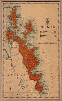
During the Spanish Occupation in 1860, six military districts were created in Mindanao, with Surigao and Agusan forming the "East District". In 1870, the district was renamed to "Distrito de Surigao". Agusan became an independent province in 1911 during the American era, when it was separated from Surigao.[3]
Independent province
Surigao del Sur was created as the 56th Philippine province on June 19, 1960 through Republic Act 2786, separated from its mother province, Surigao, on September 18, 1960.[4]
At the time of its inception, it was classified as 4th Class province with an annual income of over ₱300,000.00. Seven years later, because of rapid increase of revenue collection particularly from the logging ventures, it has been reclassified as Ist Class B and in 1980 as Ist Class A with an estimated annual income of around ₱13,000,000. It has been reclassified as 2nd Class with a revenue adding up to ₱315,888,300.63.
Recaredo B. Castillo was the appointed the first governor and subsequently elected governor and Vicente L. Pimentel as the first elected congressman. Johnny T. Pimentel is the ninth and incumbent provincial executive.
The province was formed with 13 municipalities. Six more were added, raising the number to 19 with Tandag as the capital. Two of its municipalities have been elevated to cities; the first was Bislig City. In 2007, Tandag was granted cityhood but it was nullified via a controversial decision by the Supreme Court a year later. In 2009, Tandag got back its city status after the court reversed its own ruling on December 22, 2009.
Geography
Surigao del Sur is located along the northeastern coast of Mindanao facing the Philippine Sea between 125°40' to 126°20' east longitudes and 7°55' and 9°20' north latitudes. It is bounded on the northwest by the province of Surigao del Norte, on the southeast by Davao Oriental, on the west and southwest by Agusan del Norte and Agusan del Sur.
Situated west is the Diwata Mountain Range, isolating the province from the rest of Mindanao. To the east lies the Philippine Sea. The Mindanao Deep, one of the deepest trenches in the world, is situated a few kilometers east of the coastline.[5][3]
Land area

The land area of the province is 4,932.7 square kilometres (1,904.5 sq mi)[6] representing 27.75 percent of the total land area of Caraga Administrative Region and about 5.14 percent and 1.74 percent of the total land area of Mindanao and Philippines, respectively. The province is elongated in shape, extending from the northeastern portion at Carrascal to the southernmost municipality of Lingig. It is approximately 300 kilometres (190 mi) in length and 50 kilometres (31 mi) at its widest point which runs from Cagwait to San Miguel.
Municipal-wise, San Miguel has the biggest land area accounting for 11.31% (558 square kilometers) of the total provincial land area while Bayabas has the smallest constituting only about 2.39% (117.84 square kilometers).[6]
Of the 5,230.50 square kilometres (2,019.51 sq mi) land, only 1,703.72 square kilometres (657.81 sq mi) or 32.22 percent are classified as alienable and disposable (A and D) while 3,583.523 square kilometres (1,383.606 sq mi) or 67.78 percent are forest land. Tagbina has the biggest share of alienable and disposable land with 234.21 square kilometres (90.43 sq mi) or about 56.51 percent of its land area followed by Hinatuan with 202.52 square kilometres (78.19 sq mi) or 63.56 percent of its land area.

Of the 3,583.523 square kilometres (1,383.606 sq mi) of forest land, 636.076 square kilometres (245.590 sq mi) are protection forest, 2,582.43 square kilometres (997.08 sq mi) production forest, 12.68 square kilometres (4.90 sq mi) are non-forest agriculture and 352.337 square kilometres (136.038 sq mi) are for non-forest mining. As of today, the province still has vast area of remaining old growth and mossy forest.
Climate
The province falls under Type II climate of the Philippines, characterized by rainfall distributed throughout the year, although there is a distinct rainy season which begins from the month of November and ends in March. However, the climatic behavior of the province for the past few years has shown variations wherein the onset of the rainy seasons no longer occurs on the usual time. Months with low rainfall are from July to October with September as the driest month. Wet months are from November to June with January as the wettest month.
| Climate data for Surigao del Sur | |||||||||||||
|---|---|---|---|---|---|---|---|---|---|---|---|---|---|
| Month | Jan | Feb | Mar | Apr | May | Jun | Jul | Aug | Sep | Oct | Nov | Dec | Year |
| Average high °C (°F) | 29.6 (85.3) |
30.0 (86) |
30.8 (87.4) |
31.6 (88.9) |
32.0 (89.6) |
32.2 (90) |
32.3 (90.1) |
32.5 (90.5) |
32.5 (90.5) |
32.2 (90) |
31.2 (88.2) |
30.6 (87.1) |
31.46 (88.63) |
| Average low °C (°F) | 23.4 (74.1) |
23.2 (73.8) |
23.6 (74.5) |
24.2 (75.6) |
24.4 (75.9) |
24.3 (75.7) |
24.1 (75.4) |
24.3 (75.7) |
24.1 (75.4) |
24.0 (75.2) |
23.9 (75) |
23.7 (74.7) |
23.93 (75.08) |
| Average rainy days | 24 | 21 | 20 | 19 | 16 | 16 | 14 | 14 | 13 | 17 | 17 | 21 | 212 |
| Source: Storm247 [7] | |||||||||||||
Administrative divisions
Surigao del Sur comprises 17 municipalities and two cities, further subdivided into 309 barangays. There are two congressional districts encompassing all cities and towns.
- † Provincial capital and component city
- ∗ Component city
- Municipality
| ||||||||||||||||||||||||||||||||||||||||||||||||||||||||||||||||||||||||||||||||||||||||||||||||||||||||||||||||||||||||||||||||||||||||||||||||||||||||||||||||||||||||||||||||||||||||||||||||||||||||||||||||||||||||||||||||||||||||||||||||||||||||||||||||||||||||||||||||||||||||||||||||||||
Demographics
| Population census of Surigao del Sur | ||
|---|---|---|
| Year | Pop. | ±% p.a. |
| 1990 | 452,098 | — |
| 1995 | 471,263 | +0.78% |
| 2000 | 501,808 | +1.36% |
| 2007 | 541,347 | +1.05% |
| 2010 | 561,219 | +1.32% |
| 2015 | 592,250 | +1.03% |
| Source: National Statistics Office[2][8][9] | ||
The population of Surigao del Sur in the 2015 census was 592,250 people,[2] with a density of 120 inhabitants per square kilometre or 310 inhabitants per square mile.
The province is home to the Mamanwa and Manobo tribes. Their dances are showcased in the local festival, "Sirong Festival", held especially during the town fiesta of Cantilan. The Sirong Festival depicts the early Christianization of the early Cantilan inhabitants (the Mamanwas and Manobos) wherein the natives tried to defend their land against Visayan invaders.
The Mamanwas and Manobo, the ethnic tribe of Surigao, have been Christianized during the early times of the Spanish conquest.
Languages
Tandaganon (a southern variation of Surigaonon but considered a different language) is spoken in most parts of Surigao del Sur (except in Bislig City and the towns of Barobo, Hinatuan, Lingig and Tagbina wherein most of the inhabitants are descendants of Cebuano and Boholano migrants from the Visayas who speak Cebuano or its Boholano dialect, and the natives themselves who speak Kamayo, a different language but distantly related to Surigaonon).

Cantilangnon ( a northern variation of Surigaonon which is very much similar to the dialect in Surigao City/Surigao del Norte) labelled as Surigaonon: Cantilanon (Speech variety #16956): is spoken mostly the five northern municipalities of the province, Carrascal, Cantilan, Madrid, Carmen and Lanuza. Or the municipal clusters called CARCANMADCARLAN AREA, wherein these municipalities are once under a single Municipality of Cantilan before December 10, 1918.
Filipino and English are also widely spoken throughout the province.
Economy
Surigao del Sur is one of the suppliers of rice, bananas and other tropical fruits. Copper, chromite and silver are also found here. Marine and aquaculture is abundant in the province, being a primary livelihood of the inhabitants as the province is well known for producing seafood and sea by-products.
Mineral resources
Surigao del Sur is endowed with metallic minerals such as copper, gold, chromite, cobalt, nickel and lead zinc, as well as non-metallic (limestone, coal and feldspar, clay diatomite/bentomite and coarse/fine aggregates). There are small and large scale mining activities in the province. Corporations operating in a large scale are the Marc Ventures Mining Development Corporation at Carrascal and Cantilan, operating in an area of 4,799 hectares (47.99 km2) within the Diwata Mountain Range.[10][11] The CTP Construction and Mining Corporation, also in Carrascal, focuses on gold and nickel mining in an area of 35.64 square kilometres (13.76 sq mi) and 48.6916 square kilometres (18.80 sq mi), respectively. The Carac-an Development Corporation, also in Carrascal, has an area of 506.3764 square kilometres (195.51 sq mi). Small scale mining activities are found in the municipalities of Barobo, Carmen and San Miguel.
Tourism
Bislig's main tourist attraction is the Tinuy-an Falls,[12] known as the little "Niagara Falls of the Philippines". It is a white water curtain that flows in three levels about 55 metres (180 ft) high and 95 metres (312 ft) wide.[13] Its unique natural formation once appeared in the International Travel Magazine. It is also known as the widest waterfall in the Philippines.
Surfing in Surigao del Sur is widely known and has been one of the local tourist attractions. This extreme sport is often practiced in Cantilan and Lanuza.[14] Skimboarding is also played in several municipalities, attracting tourists.
 Deep-blue waters of the renowned "Hinatuan Enchanted River", an underground river in Brgy. Talisay, Hinatuan
 The Tinuy-an Falls in Burboanan, Bislig
 Surfing in Lanuza
See also
References
- ↑ "List of Provinces". PSGC Interactive. Makati City, Philippines: National Statistical Coordination Board. Retrieved 1 April 2014.
- 1 2 3 4 Census of Population (2015): Highlights of the Philippine Population 2015 Census of Population (Report). PSA. Retrieved 20 June 2016.
- 1 2 3 4 Lancion, Jr., Conrado M.; cartography by de Guzman, Rey (1995). "The Provinces; Surigao del Sur". Fast Facts about Philippine Provinces (The 2000 Millenium ed.). Makati, Metro Manila, Philippines: Tahanan Books. p. 156. ISBN 971-630-037-9. Retrieved 28 April 2016.
- ↑ "Republic Act No. 2786 - An Act to Create the Provinces of Surigao del Norte and Surigao del Sur". Chan Robles Virtual Law Library. 19 June 1960. Retrieved 11 January 2016.
- ↑ "Philippine Provincial Profile; Surigao del Sur". OoCities.org. Retrieved 28 April 2016.
- 1 2 3 4 "Province: Surigao del Sur". PSGC Interactive. Quezon City, Philippines: Philippine Statistics Authority. Retrieved 8 January 2016.
- ↑ "Weather forecast for Surigao del Sur, Philippines". Storm247.com. StormGeo AS, Nordre Nøstekaien 1, N-5011 Bergen, Norway: StormGeo AS. Retrieved 29 April 2016.
- 1 2 Census of Population and Housing (2010): Population and Annual Growth Rates for The Philippines and Its Regions, Provinces, and Highly Urbanized Cities (PDF) (Report). NSO. Retrieved 29 June 2016.
- ↑ "CARAGA". Census of Population and Housing (2010): Total Population by Province, City, Municipality and Barangay (Report). NSO. Retrieved 29 June 2016.
- ↑ "Marcventure's mining operations in Cantilan, Surigao del Sur, Philippines". Environmental Justice Atlas. Retrieved 18 April 2016.
On July 1, 1993, Marcventure Mining and Development Corporation (MMDC) received a mining permit covering 4,799ha, located in the Diwata Mountain Range, Cantilan, Surigao del Sur.
- ↑ Galvez, James Konstantin (24 April 2014). "DENR shuts down Surigao del Sur mining firm". The Manila Times. Retrieved 18 April 2016.
MMDC, a subsidiary of publicly listed Marcventures Holdings Inc., is engaged in nickel production in Surigao del Sur. The company holds a mineral production sharing agreement (MPSA) for a 4,799- hectare tenement located in Cantilan, Surigao del Sur.
- ↑ Crismundo, Mike (22 September 2015). "Caraga tourist arrivals to reach 2M by end of 2015". Manila Bulletin. Retrieved 18 April 2016.
Frequently visited by this huge volume of tourists are the famous “Cloud 9” and amazing beach resorts and islets in Siargao Island, the Sohoton Cove in Bucas Grande Island in Socorro town, the game fishing hub in Pilar, all in Siargao Island in Surigao del Norte, the Enchanted River in Hinatuan, Surigao del Sur, the Tinuy-an Falls in Bislig City and Balanghai in Butuan City.
- ↑ Alcantara, Jojie (11 February 2005). "Tinuy-an Falls: Our little Niagara". Sun.Star Davao. Archived from the original on 28 April 2005. Retrieved 18 April 2016.
Tinuy-an is a three-tiered falls (there is a fourth but cannot be seen from view) about 55 meters high and a breathtaking width of 95 meters, supposedly the widest in the country.
- ↑ Mascariñas, Erwin (11 November 2012). "LGU wants to make Cantilan a surfing destination". MindaNews. Mindanao News and Information Cooperative Center. Retrieved 28 April 2016.
External links
-
 Media related to Surigao del Sur at Wikimedia Commons
 -
 Geographic data related to Surigao del Sur at OpenStreetMap
 - Local Governance Performance Management System
- Surigao del Sur provincial profile at Philippine Provincial Profiles
 |
Agusan del Norte | Surigao del Norte | | |
| Agusan del Sur | |
Philippine Sea | ||
| ||||
| | ||||
| Davao Oriental |
Tandag (capital) | |
| Municipalities | |
| Component cities | |


