Quezon


Quezon (Tagalog pronunciation: [ˈkɛson]) is a province of the Philippines in the Calabarzon region of Luzon island. The province was named after Manuel L. Quezon, the second President of the Philippines, and its capital is Lucena City.
Quezon is southeast of Metro Manila and is bordered by the provinces of Aurora to the north, Bulacan, Rizal, Laguna and Batangas to the west and the provinces of Camarines Norte and Camarines Sur to the east. Part of Quezon lies on an isthmus connecting the Bicol Peninsula to the main part of Luzon. The province also includes the Polillo Islands in the Philippine Sea.
A major tourism draw to the province is Mount Banahaw. The mountain is surrounded by spiritual mysticism with many cults and religious organizations staying on the mountain. Numerous pilgrims visit the mountain especially during Holy Week.
History
Precolonial and Spanish eras
Originally, what now forms Quezon was divided among the provinces of Batangas, Laguna, and Nueva Ecija. The first European to explore the area was Juan de Salcedo in 1571-1572, during his expedition from Laguna to Camarines provinces.[3][4]
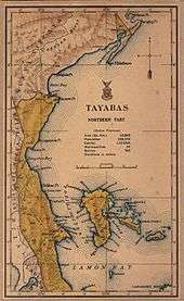
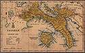
In 1591, the province was created and called Kaliraya or Kalilayan, after the capital town which later became Unisan. In 1749, the capital was transferred to the town of Tayabas, from which the province got its new name.[3]
Depredation and plunder by the Moros were rampant during the Spanish regime, because they opposed the colonizers, especially in their efforts to spread Christianity. The destruction of Kalilayan in 1604 by a big fleet of Moro pirates caused the inhabitants to transfer to Palsabangon (Pagbilao).
However, even the colonized people grew discontented with the Spaniards over the centuries. The most important event in the history of the province was the Confradia Revolt in 1841, which was led by the famous Lucbano, Apolinario de la Cruz, popularly known as Hermano Pule. The province, under General Miguel Malvar, was also among the earliest to join the Philippine Revolution. The Revolutionary Government took control over the province on August 15, 1898.
American period and World War II
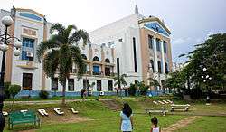
The Americans then came and annexed the Philippines. A civil government was established in the province on March 12, 1901, and Lucena was made the provincial capital.
Japanese occupation of the province during World War II began on December 23, 1941, when the Japanese Imperial Army landed in Atimonan. The General Headquarters of the Philippine Commonwealth Army and Philippine Constabulary was stationed in Tayabas from January 3, 1942 to June 30, 1946 are military operates against the Japanese Occupation. The occupation witnessed the brutal murders of prominent sons of Tayabas. April 4, 1945 was the day the province was liberated as the combined Filipino and American army forces reached Lucena.
After the war, on September 7, 1946, Republic Act No. 14 changed the name Tayabas to Quezon, in honor of Manuel L. Quezon, the Commonwealth president who hailed from Baler, which was one of the province's towns.[5]
Separation of Aurora sub-province
In June 1951, the northern part of Quezon (specifically, the towns of Baler, Casiguran, Dipaculao and Maria Aurora ) was made into the sub-province of Aurora.[6] Aurora was the name of the president's wife, Aurora Quezon. Aurora was finally separated from Quezon as an independent province in 1979.[7]
Attempted splitting of Quezon
In 2007, Republic Act No. 9495 was proposed to further divide Quezon into Quezon del Norte and Quezon del Sur. Quezon del Norte was to be composed of the first and second congressional districts of the province (Burdeos, General Nakar, Infanta, Jomalig, Lucban, Mauban, Pagbilao, Panukulan, Patnanungan, Polilio, Real, Sampaloc, Tayabas, Candelaria, Dolores, San Antonio, Sariaya, Tiaong and Lucena), with Lucena as its capital. Quezon del Sur, with its capital at Gumaca, would have been composed of the third and fourth congressional districts (Agdangan, Buenavista, Catanauan, General Luna, Macalelon, Mulanay, Padre Burgos, Pitogo, San Andres, San Francisco, San Narciso, Unisan, Alabat, Atimonan, Calauag, Guinayangan, Gumaca, Lopez, Perez, Plaridel, Quezon and Tagkawayan). The act lapsed into law without the signature of President Gloria Macapagal-Arroyo on September 7, 2007.[8]
As required by law, the COMELEC held a plebiscite on December 13, 2008, 60 days after Republic Act No. 9495 took effect. The majority of the votes cast rejected the division, therefore the split did not push through.
Geography


Quezon, east of Metro Manila, is the 8th largest province in the Philippines having an area of 8,989.39 square kilometres (3,470.82 sq mi).[9] The northern part of the province is sandwiched between the Sierra Madre mountain range and the Philippine Sea. The southern part consists of the Tayabas Isthmus, which separates the Bicol Peninsula from the main part of Luzon Island, and the Bondoc Peninsula which lies between Tayabas Bay and Ragay Gulf.
The major islands of Quezon are Alabat Island and Polillo Islands. Mount Banahaw, an active volcano, is the highest peak at 2,169 metres (7,116 ft).[10] It supplies geothermal power to the Mak-Ban Geothermal Power Plant.[11]
Administrative divisions
Quezon comprises 39 municipalities and one component city named Tayabas City, which are organized into four legislative districts and further subdivided into 1,209 barangays.
The capital, Lucena City, is independent from the administrative and fiscal supervision of the province, but is eligible to vote for provincial officials.
There is an active movement to declare the Polilo Islands as a separate province from Quezon due to much geographic constraint and cultural differences.
| ||||||||||||||||||||||||||||||||||||||||||||||||||||||||||||||||||||||||||||||||||||||||||||||||||||||||||||||||||||||||||||||||||||||||||||||||||||||||||||||||||||||||||||||||||||||||||||||||||||||||||||||||||||||||||||||||||||||||||||||||||||||||||||||||||||||||||||||||||||||||||||||||||||||||||||||||||||||||||||||||||||||||||||||||||||||||||||||||||||||||||||||||||||||||||||||||||||||||||||||||||||||||||||||||||||||||||||||||||||||||||||||||||||||||||||||||||||||||||||||||||||||||||||||||||||||||||||||||||||||||||||||||||||||||||||||||||||||||||||||||||||||||||||||||||
Demographics
| Population census of Quezon | ||
|---|---|---|
| Year | Pop. | ±% p.a. |
| 1990 | 1,221,831 | — |
| 1995 | 1,359,992 | +2.03% |
| 2000 | 1,482,955 | +1.87% |
| 2007 | 1,646,510 | +1.45% |
| 2010 | 1,740,638 | +2.04% |
| 2015 | 1,856,582 | +1.24% |
| (excluding Lucena City) Source: Philippine Statistics Authority[2][12][13] | ||
The population of Quezon in the 2015 census was 1,856,582 people,[2] with a density of 210 inhabitants per square kilometre or 540 inhabitants per square mile. When Lucena City is included for geographical purposes, the province's population is 2,122,830 people, with a density of 234/km2 (606/sq mi).
The inhabitants are mostly Tagalogs. The population is concentrated in the flat south-central portion which includes Lucena City, Sariaya, and Candelaria. After World War II, the Infanta area received migrants from Manila, Laguna and Batangas. People from Marinduque moved to the southern part of the Tayabas Isthmus and the Bondoc Peninsula. And people from Bicol Region migrated to Southern Towns of Calauag and Tagkawayan.
Economy
Quezon is the country's leading producer of coconut products such as coconut oil[4] and copra. A large part of the province is covered in coconut plantations. Other major crops are rice, corn, banana, and coffee. Fishing is also a large part of the province's economy.
Notable people
- Manuel L. Quezon, the second President of the Philippines — Baler (now a part of Aurora)
- Tomas Morato, last municipal President and first Mayor of Calauag and Quezon City, First Representative of the 2nd District of Tayabas, Manuel L. Quezon's best friend — Calauag
- Vitaliano Aguirre, current Secretary of Justice — Mulanay
- Manoling Morato, former Chairman of the Philippine Charity Sweepstakes Office — Calauag
- Claro M. Recto, former Minority leader of the Senate of the Philippines, former Associate Justice of the Philippine Supreme Court — Tiaong
- Rey Danseco, Sports Editor and WBC boxing judge — Calauag, Lopez, and Gumaca
- Aiza Seguerra, Filipino actress and singer — Calauag
- Raymundo Punongbayan, former director, PHIVOLCS — Calauag
- Mark Magsumbol, first Filipino player in 31-team American Basketball Association (ABA) — Calauag
- Agnes Devanadera, former Solicitor-General and Secretary of the Department of Justice — Sampaloc
- Lorenzo Tañada, former Senator — Gumaca
- Wigberto Tañada, former Liberal Party President and former senator — Gumaca
- Lorenzo Tañada III, Congressman, Liberal Party Spokesman — Gumaca
- Proceso Alcala, Secretary, Department of Agriculture — Lucena City
- Tommy Abuel, actor — Lucban
- Ana Capri, actress — Infanta
- Raimund Marasigan, musician (Eraserheads, Sandwich, Pedicab, Cambio) — Candelaria
- Romeo Vasquez, actor — Tayabas City
- Edgar Mortiz, actor/director — Infanta
- Orlando Nadres, writer/screenwriter/director — Tayabas City
- Angel Lagdameo, Archbishop of the Archdiocese of Jaro and former President of the Catholic Bishops' Conference of the Philippines — Lucban
- Kris Psyche Resus, Miss Philippines Earth 2010 — Infanta
- Lily Monteverde, movie producer — Sariaya
- Alice Dixson, actress - Philippine Cinema — Guinayangan
- Chris Tsuper, Radio DJ of Love Radio — Lucena City
- Gil M. Portes, a Filipino film director, film producer and screenwriter — Pagbilao
- Mau Marcelo, winner, Philippine Idol TV5 — Lucena
- Leo Oracion, First Filipino Mountaineer to successfully reach the Mt. Everest Summit — Lucban, Quezon
- Mac Baracael, a professional Filipino basketball player — Pagbilao, Quezon
Metro Lucena
Metro Lucena has an estimated population of 700,000 which is mostly concentrated in the flat south-central portion of Quezon, which includes the cities of Lucena City and Tayabas City, Sariaya, Candelaria, Lucban & Pagbilao. The people are often characterized as friendly and hardworking. It is the center of commerce and tourism in Quezon Province.
References
- ↑ "List of Provinces". PSGC Interactive. Makati City, Philippines: National Statistical Coordination Board. Archived from the original on January 21, 2013. Retrieved 22 November 2013.
- 1 2 3 4 Census of Population (2015): Highlights of the Philippine Population 2015 Census of Population (Report). PSA. Retrieved 20 June 2016.
- 1 2 "History of Quezon Province". Provincial Government of Quezon. Retrieved 4 April 2016.
- 1 2 Ramos, Lily O. (18 July 2012). "Quezon province's impressive historical and cultural heritage". Balita.ph. Retrieved 4 April 2016.
- ↑ "Republic Act No. 14; An Act to Change the Name of the Province of Tayabas to Quezon". Chan Robles Virtual Law Library. Retrieved 6 January 2016.
- ↑ "Republic Act No. 648 - An Act Creating the Subprovince of Aurora, Which Shall Comprise the Municipalities of Baler, Casiguran, Dipaculao and Maria Aurora, Province of Quezon". Chan Robles Virtual Law Library. 14 June 1951. Retrieved 4 April 2016.
- ↑ "Batas Pambansa Blg. 7 - An Act Separating the Sub-Province of Aurora from the Province of Quezon and Establishing It as an Independent Province". Chan Robles Virtual Law Library. Retrieved 4 April 2016.
- ↑ "Republic Act No. 9495: An Act Creating the Province of Quezon del Sur". The LAWPHiL Project. September 7, 2007. Retrieved 22 November 2013.
- 1 2 3 "Province: Quezon". PSGC Interactive. Quezon City, Philippines: Philippine Statistics Authority. Retrieved 8 January 2016.
- ↑ "Active Volcanoes". Philippine Institute of Volcanology and Seismology. 30 July 2008. Retrieved 6 January 2016.
- ↑ "Makiling-Banahaw". National Geothermal Association of the Philippines, Inc. (NGAP). Retrieved 26 June 2016.
- 1 2 Census of Population and Housing (2010): Population and Annual Growth Rates for The Philippines and Its Regions, Provinces, and Highly Urbanized Cities (PDF) (Report). NSO. Retrieved 29 June 2016.
- ↑ "Region IV-A (CALABARZON)". Census of Population and Housing (2010): Total Population by Province, City, Municipality and Barangay (Report). NSO. Retrieved 29 June 2016.
External links
-
 Media related to Quezon at Wikimedia Commons
 -
 Geographic data related to Quezon at OpenStreetMap
 - Official website of Quezon province
- Local Governance Performance Management System
 |
Bulacan | Aurora | Lamon Bay, Philippine Sea | |
| Rizal Laguna Batangas |
|
Camarines Norte Camarines Sur | ||
| ||||
| | ||||
| Tayabas Bay Marinduque |
Sibuyan Sea, Ragay Gulf Masbate |
Lucena (capital) | |
| Municipalities |
|
| Component city | |
| Highly urbanized city |
|
| ||||||||||||||||||||||||||||||||||||||||||||||||||||||||||||||||||||||||||||||||||||||||||||||||||||||||||||||||||||||||||||||||||||||||||||||||||||||||||||||||||||||||||


