Aurora (province)
| Aurora | |||
|---|---|---|---|
| Province | |||
| Province of Aurora | |||
|
Aurora Provincial Capitol | |||
| |||
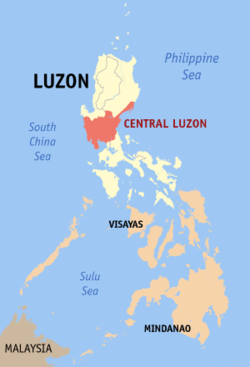
 Location in the Philippines | |||
| Coordinates: 15°53′N 121°33′E / 15.88°N 121.55°ECoordinates: 15°53′N 121°33′E / 15.88°N 121.55°E | |||
| Country | Philippines | ||
| Region | Central Luzon (Region III) | ||
| Founded | 1951 (as sub-province of Quezon) | ||
| Province | 13 August 1979 | ||
| Capital | Baler | ||
| Government | |||
| • Type | Sangguniang Panlalawigan | ||
| • Governor | Gerardo A. Noveras (NPC) | ||
| • Vice-Governor | Rommel Rico T. Angara (LDP) | ||
| Area[1] | |||
| • Total | 3,147.32 km2 (1,215.19 sq mi) | ||
| Area rank | 42nd out of 81 | ||
| Population (2015 census)[2] | |||
| • Total | 214,336 | ||
| • Rank | 70th out of 81 | ||
| • Density | 68/km2 (180/sq mi) | ||
| • Density rank | 77th out of 81 | ||
| Divisions | |||
| • Independent cities | 0 | ||
| • Component cities | 0 | ||
| • Municipalities |
8
| ||
| • Barangays | 151 | ||
| • Districts | Lone district of Aurora | ||
| Demographics | |||
| • Ethnic groups |
| ||
| • Languages | |||
| Time zone | PST (UTC+8) | ||
| ZIP code | 3200–3207 | ||
| IDD : area code | +63 (0)42 | ||
| ISO 3166 code | PH-AUR | ||
| Website |
www | ||


Aurora is a province in the Philippines located in the eastern part of Central Luzon region, facing the Philippine Sea. Its capital is Baler and borders, clockwise from the south, the provinces of Quezon, Bulacan, Nueva Ecija, Nueva Vizcaya, Quirino, and Isabela.
Before 1979, Aurora was part of the province of Quezon. Aurora was, in fact, named after Aurora Aragon, the wife of Pres. Manuel L. Quezon, the president of the Philippine Commonwealth, after whom the mother province was named.
History
Spanish era
In 1572, the Spanish explorer Juan de Salcedo became the first European to visit the region that would be known as Aurora while he was exploring the northern coast of Luzon. Salcedo reportedly visited the towns of Casiguran, Baler and Infanta.
In the early days of the Spanish colonial period, Aurora was ecclesiastically linked to Infanta, which today rests further south, in northern Quezon. The earliest missionaries in the province were the Franciscans, who had established missions in Baler and Casiguran in 1609.[3] Due to lack of available personnel, the region was given to the jurisdiction of the Augustinians and Recollects in 1658, but was returned to the Friars Minor in 1703. Other early missions included Dipaculao, established in 1719, and Casiguran, in 1753.
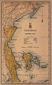
District of El Principe
The early history of Aurora is linked to Quezon province, of which it formed a part, and Nueva Ecija, under which the area was governed as the District of El Príncipe. In 1902, the district was separated from Nueva Ecija and transferred to the province of Tayabas (now Quezon).[3][4]
Independence
Aurora became a sub-province of Quezon in 1951 through Republic Act No. 648,[5] and finally became an independent province during the presidency of Ferdinand E. Marcos, through Batas Pambansa Blg. 7 enacted on August 13, 1979.[3][6]
Geography
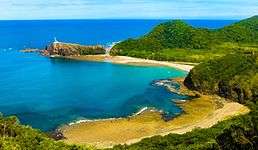
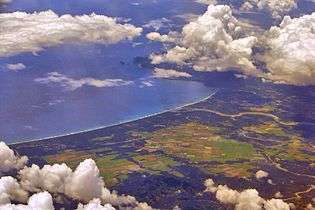
Aurora is a coastal province covering an area of 3,147.32 square kilometres (1,215.19 sq mi)[7] in east-central Luzon. To the north, it is bordered by the Northern Sierra Madre Natural Park of Isabela, to the west by the central range of the Sierra Madre which contains the Casecnan Protected Landscape and Aurora Memorial National Park, to the south by the Umiray River, and to the east by the Philippine Sea which opens to the Philippine Sea. The San Ildefonso Peninsula lies in the province's northern portion between the Philippine Sea and the Casiguran Sound.
Topography
The province covers a portion of the Sierra Madre mountain range. As such, the elevation is generally steep to very steep and only about 14% of the province's total area is flat.[3]
Climate
Aurora's climate is classified as Tropical rainforest climate.[8] It experiences significant rainfall throughout the year.[8] Because the coastal province faces the Pacific Ocean, it is frequently visited by typhoons.[3][9]
Administrative divisions
Aurora is politically subdivided into 8 municipalities, all encompassed by a lone legislative district.
|
 | |||||||||||||||||||||||||||||||||||||||||||||||||||||||||||||||||||||||||||||||||||||||||||||||||||||||||||||||||||||||||||||||||||||||||||||||||||||||||||||
Barangays
The 8 municipalities of the province comprise a total of 151 barangays, with Suclayin in Baler as the most populous in 2010, and Dibalo in San Luis as the least.[10]
Demographics
| Population census of Aurora | ||
|---|---|---|
| Year | Pop. | ±% p.a. |
| 1990 | 139,573 | — |
| 1995 | 159,621 | +2.55% |
| 2000 | 173,797 | +1.84% |
| 2007 | 187,802 | +1.07% |
| 2010 | 201,233 | +2.55% |
| 2015 | 214,336 | +1.21% |
| Source: National Statistics Office[2][10][10] | ||
The population of Aurora in the 2015 census was 214,336 people,[2] with a density of 68 inhabitants per square kilometre or 180 inhabitants per square mile.
Based on the 2000 census survey, Tagalogs comprised 52.85% (91,745) of the total provincial population of 173,589, and about less than 1/3 of the population were Ilocano at 31.43% (54,557). Other ethnic groups in the province were Kasiguranin at 5.1% (8,853), Bicolano at 4.08% (7,079), Kankanaey at 1.36% (2,355), Bisaya at 0.88% (1,529), Dumagat (Umiray) at 0.6% (1,047), and Cebuano at 0.48% (832).[11]
There are also pockets of Negritos, called Dumagats. Most Dumagats are living in the hillsides or mountains. They are believed to have result from a fusion of Austronesian and Melanesian ancestries, and survive from fishing and hunting. There are three kinds of Dumagats in Aurora province, the Umiray Dumagat, Casiguran Dumagat, and the Palanan Dumagat.

Religion
The people of Aurora are heavily Christianized (large majority being Roman Catholic by 87%) as a result of hundreds of years of Spanish colonization. Some other Christian believers are also present which includes Aglipayan Church, Baptists, Born Again Christians, Jehovah's Witnesses, Iglesia Ni Cristo and Seventh-day Adventist while Muslims are also found which presence is traced to migration by some people from some parts of Mindanao.
Economy
Corn crops, rice and other major agricultural crops are grown in Aurora. It has a total of 38, 928 or 13% of provincial Land Area of Agricultural land. It also has 8,945 hectares (22,100 acres) of rice plantation that averages 24,000 ton every years.
Aurora Pacific Economic Zone
Casiguran is home to the Aurora Pacific Economic Zone and Freeport Authority or APECO a special economic zone located in this coastal town. Created in 2007 by virtue of Republic Act No. 9490 through the efforts of Sen. Edgardo Angara and Rep. Juan Edgardo Angara, it is expected be a major transshipment hub going to the pacific region. It aims to boost social, economic and industrial developments in Aurora and nearby provinces by generating jobs for the people, improving the quality of their living conditions, advocating an eco-friendly approach to industrialization and enhancing the potential of the community in productivity.
Gallery
-
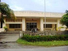
Bulwagan ng Katarungan
(RTC), Suklayin, Baler -

Aurora Police Provincial Office, NPC, PNP, Baler
-
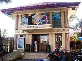
Aurora Provincial Tourism Office (Suklayin)
-
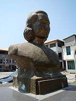
Bust of Maria Aurora
See also
References
- ↑ "List of Provinces". PSGC Interactive. Makati City, Philippines: National Statistical Coordination Board. Archived from the original on 21 January 2013. Retrieved 22 October 2013.
- 1 2 3 4 "Region III (CENTRAL LUZON)". Census of Population (2015): Total Population by Province, City, Municipality and Barangay (Report). PSA. Retrieved 20 June 2016.
- 1 2 3 4 5 Lancion, Jr., Conrado M.; cartography by de Guzman, Rey (1995). "The Provinces; Aurora". Fast Facts about Philippine Provinces (The 2000 Millenium ed.). Makati, Metro Manila, Philippines: Tahanan Books. p. 28. ISBN 971-630-037-9. Retrieved 4 December 2015.
- ↑ National Historical Commission of the Philippines. "History of Baler". National Historical Commission of the Philippines. Retrieved 2012-03-09.
When military district of El Príncipe was created in 1856, Baler became its capital...On June 12, 1902 a civil government was established, moving the district of El Príncipe away from the administrative jurisdiction of Nueva Ecija...and placing it under the jurisdiction of Tayabas Province.
- ↑ "Republic Act No. 648 - An Act Creating the Subprovince of Aurora, Which Shall Comprise the Municipalities of Baler, Casiguran, Dipaculao and Maria Aurora, Province of Quezon". Chan Robles Virtual Law Library. Retrieved 8 December 2015.
- ↑ "Batas Pambansa Blg. 7 - An Act Separating the Sub-province of Aurora from the Province of Quezon and Establishing It as an Independent Province". Chan Robles Virtual Law Library. Retrieved 8 December 2015.
- 1 2 "Province: Aurora (province)". PSA. Philippines: National Statistical Coordination Board. Retrieved 8 January 2016.
- 1 2 "Climate: Aurora". Climate-data.org. Retrieved 8 December 2015.
- ↑ Iglesias, Iza; Vargas, Anthony; Cueto, Francis Earl A. (17 October 2015). "3 days of heavy rain". The Manila Times. Retrieved 8 December 2015.
- 1 2 3 4 "Region III (CENTRAL LUZON)". Census of Population and Housing (2010): Total Population by Province, City, Municipality and Barangay (Report). NSO. Retrieved 29 June 2016.
- 1 2 "Aurora: Housing Unit Occupancy Rate Almost 100 Percent; Table 4. Household Population by Ethnicity and Sex: Aurora, 2000". National Statistics Office. 11 June 2002. Archived from the original on 5 March 2015. Retrieved 26 July 2016.
External links
-
 Media related to Aurora at Wikimedia Commons
 -
 Geographic data related to Aurora (province) at OpenStreetMap
 |
Nueva Vizcaya | Quirino, Isabela | | |
| Nueva Ecija | |
Philippine Sea | ||
| ||||
| | ||||
| Bulacan | Quezon |
Baler (capital) | |
| Municipalities | |
| Barangays | |