Southern Leyte
| Southern Leyte | |||
|---|---|---|---|
| Province | |||
| Province of Southern Leyte | |||
| |||
 Location in the Philippines | |||
| Coordinates: 10°20′N 125°05′E / 10.33°N 125.08°ECoordinates: 10°20′N 125°05′E / 10.33°N 125.08°E | |||
| Country | Philippines | ||
| Region | Eastern Visayas, Tacloban | ||
| Founded | May 22, 1959 | ||
| Capital | Maasin | ||
| Government | |||
| • Type | Sangguniang Panlalawigan | ||
| • Governor | Roger Mercado (NUP) | ||
| • Vice Governor | Shefferd Lino Tan (Liberal) | ||
| Area[1] | |||
| • Total | 1,798.61 km2 (694.45 sq mi) | ||
| Area rank | 65th out of 81 | ||
| Population (2015 census)[2] | |||
| • Total | 421,750 | ||
| • Rank | 62nd out of 81 | ||
| • Density | 230/km2 (610/sq mi) | ||
| • Density rank | 40th out of 81 | ||
| Divisions | |||
| • Independent cities | 0 | ||
| • Component cities |
1
| ||
| • Municipalities | |||
| • Barangays | 500 | ||
| • Districts | Lone District of Southern Leyte | ||
| Time zone | PHT (UTC+8) | ||
| ZIP code | 6600–6618 | ||
| IDD : area code | +63 (0)53 | ||
| ISO 3166 code | PH-SLE | ||
| Spoken languages | |||
| Website |
www | ||

Southern Leyte (Cebuano: Habagatang Leyte, Filipino: Timog Leyte) is a province in the Philippines located in the Eastern Visayas region. Its capital is the city of Maasin. Southern Leyte was a sub-province of Leyte until it was made into an independent province. Southern Leyte includes Limasawa, an island to the south where the first Roman Catholic Mass was held and considered to be the birthplace of Roman Catholicism in the Philippines.[3]
The province ranks as the second least populated in the region. According to the 2015 census, the province has a population of 421,750.[2]
Southern Leyte's geological features created several issues in the province after the flooding of the Subangdaku River and the 2006 mudslide in Guinsaugon. Organizations warned the province it was susceptible to natural occurrences like landslides and floods.[4]
Southern Leyte forms an important part of the inter-island transportation system of the country, with ferries transporting people and goods between Liloan and Surigao del Norte in Mindanao. The province is well known for its quality abaca products and is the country's major producer of abaca fiber.
History
Precolonial history
The province, being part of Leyte island, is believed to be influenced by Datu Ete, ruler of the historic community of Mairete, meaning Land of Ete. The area which is to be Southern Leyte is believed to have been occupied by animist Visayan ethnic groups from Bohol. There is no proof that the indigenous animist Warays of Samar, who at the time occupied northeast Leyte, ever occupied Southern Leyte.
Early settlement
As early as 1898 during the Spanish and American periods, there had already existed a "sub-province" consisting of the municipalities from Palompon to Hinunangan, with Maasin as the center. Some government offices had already been established in Maasin on the southwestern part of Leyte to govern the area.[5]
Historically, the governing city was the depository of cedula tax collections from Palompon to Hinunangan. This was administered by the office of the Administrado de Hacienda, equivalent to the Provincial Treasurer, a position under the Secretario de Hacienda.
There was also established in Maasin a Court of First Instance, then known as the Promoter Fiscal, where all minor administrative and other cases from Palompon to Hinunangan were heard.[6]

During the Spanish colonization, the province was sparsely populated. The continued raiding of Moro slaves discouraged the province from growing and developing. However, in the 19th century immigrants from adjacent provinces like Bohol and Cebu populated the area.
In 1942, Ruperto Kangleon held a conference in the town of Sogod, when the first meeting attempt in Malitbog, a town to the east, failed due to many leaders staying away. He was trying to unify all guerrillas helping the Philippine Commonwealth troops during World War II.[7]
From 1944 to 1945, the Allied Philippine Commonwealth Army soldiers and Filipino guerrillas attacked the Japanese Imperial forces in an effort to liberate Southern Leyte, and American troops landed on Leyte on October 20, 1944.
Independent province
Due to a change of sovereign powers, all the offices in Maasin except the Fiscal’s Office were abolished and reverted to Tacloban, the capital of Leyte. This created a major problem because of the dearth of transportation, the difficulty in managing the affairs of government in Tacloban and the language barrier between the Cebuano-speaking South-westerners and the Waray Easterners. The difficulty of managing the entire island from the main city suggested a need to separate the island into two provinces.
At first there was a general movement for a Western Leyte and soon after, many prominent men and leaders rallied behind the movement. Six attempts to pass a law for the division of Leyte were made. On the sixth attempt, then Congressman Nicanor Yñiguez introduced into the House a division law similar in substance to that of the Kangleon Bill, but recognizing the impossibility of creating an East-West Division, he instead opted to make his own district a province.
Abandoning the first bill, Congressman Nicanor Yñiguez presented House Bill No. 1318 proposing a new province of Southern Leyte comprising Third Congressional District of Leyte to include sixteen municipalities, from Maasin to Silago in the mainland, and in the Panaon Island.
The bill became Republic Act 2227 otherwise known as an "Act Creating the Province of Southern Leyte" and was signed into Law by President Carlos P. Garcia on May 22, 1959.[8] On July 1, 1960, Southern Leyte was inaugurated as a province with sixteen municipalities and Maasin as the capital town. Thus, the third District of Leyte became the Province of Southern Leyte and the Lone District of Southern Leyte.[5][6]
Mudslides
In December 2003, a landslide in San Francisco, Southern Leyte destroyed most of the town, killing 200 people.[9][10]
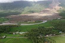
On February 17, 2006, several mudslides caused by heavy rains, amounting over 200 cm (79 in), and a minor earthquake destroyed at least one town and many commercial and residential infrastructures, leaving hundreds dead. The municipality of Saint Bernard was one of the worst hit areas with 23 confirmed deaths, up to 200 estimated deaths and another 1,500 missing. Barangay Guinsaugon, a mountain village on the said municipality with 2,500 people, was almost completely destroyed, killing 1,800 of its 1,857 residents. Many rescuers from national and international responded to the incident. However, rescue efforts were greatly hampered by poor road conditions and lack of heavy equipment. Survivors reported also lack of coordination of rescue efforts. The Philippine Government again stated their inability to cope with disasters. The few handful of Guinsaugon citizens which escaped the mudslide were put up in emergency shelters without adequate nutrition and care despite the National Government collecting millions of dollars worth of donations.
Geography
Southern Leyte occupies the southern quarter of the island of Leyte. It is bounded by the province of Leyte to the north, by Surigao Strait to the east, Bohol Sea to the south, and Canigao Channel, across from Bohol, to the west. Its total land area is 1,798.61 square kilometres (694.45 sq mi).[11] The central portion of the province is dominated by the Sogod Bay, a long bay that cuts deep into the island.
Topography

Southern Leyte is characterized by relatively flat lands along the coastal areas where population centers lie, but rugged mountains towards the interior.
The province has inland water features. Based on national data, the province has altogether 93 rivers including 18 major ones, namely the Amparo River in Macrohon, the Canturing River in Maasin City, the Das-ay and Pondol Rivers in Hinunangan, the Divisoria River in Bontoc, the Hitungao and Lawigan Rivers in San Juan, the Maag River in Silago, and the Subangdaku River in Sogod which is the biggest of all.[12] The province has an inland lake called Lake Danao located in the mountains of San Juan and Anahawan, towns in the eastern region.

Subangdaku, the province's largest river, created an issue over the area. It can be considered a braided river composed of several channels from near areas that divide and reunite forming an alluvial fan with a very wide floodplain. As such, the river usually became hazardous during typhoons after heavy rains.[13] The river has overflowed, spilling its waters on the low-lying towns of Liloan and San Vicente and destroyed an ongoing flood control project worth millions of pesos.[14] The river meanders along its course, ever changing its way over time.[15] During the time it floods, it destroys every side of its course. In 2001, portions of the road and banks in Barangay San Miguel along the river were destroyed,[13] including part of the Philippine National Road. Local officials blamed the rechannelization and uncontrolled quarrying of gravel and sand at the side of river as the cause of the flood.[16] At a meeting on March 18, 2002, one of the representatives of a government agency alleged that the reason of the incidents of flood and other environmental problems in the river was due to the "Philippine Fault" which caused rocks to rumble down. However, the reason was contended because the fault is a geological feature and environmental problems in the province just occurred that time.[13]
Along with other mountain forms in the province, Mount Nacolod in Hinunangan town has the highest peak with an elevation of 948 metres (3,110 ft) above sea level. Young volcanic rocks are discovered in the terrain areas, which cover the top of the southern mountain ranges of Mount Cabalian in the Pacific Area and Mount Nelangcapan in Panaon Area.[6]
The province lies within the Philippine Fault System. The major fault lines traverse the municipalities of Sogod, Libagon, Saint Bernard and San Juan to Panaon Island. Based on Mines and Geosciences Bureau Region 8 data, these areas had experienced strong earthquakes in 1907 and 1948 with a magnitude of 6.9 and on July 5, 1984 with a 6.4 scale.[6] The Mines and Geosciences Bureau warned that Southern Leyte's natural and geological features make it susceptible to landslides and floodings.[17] The affiliated group stated that there are four contributory reasons: unusually heavy rains; numerous faults and badly broken rocks; steep slopes; and absence of effective vegetative cover.[4]
The province has numerous types of soil. Soil types within the Maasin Clay, Guimbalaon Clay, Himay-angan Clay, Bolinao Clay, Quingua Clay and Malitbog Clay series serve as raw materials for ceramics and pottery made by local residents.
Climate
Southern Leyte has two types of climate according to the Coronas Classification. These are Type II and Type IV.
Type II is characterized by the absence of dry season with a very pronounced maximum rain period occurring from November to January. This type prevails in the eastern half of the province that includes the municipality of Sogod, Libagon, Liloan, San Francisco, Pintuyan, San Ricardo, Saint Bernard, San Juan, Anahawan, Hinundayan, Hinunangan and Silago. On the other hand, Type IV has a rainfall that is more or less evenly distributed throughout the year. This type prevails in the western part of the province that includes the City of Maasin and the municipalities of Macrohon, Padre Burgos, Limasawa, Malitbog, Tomas Oppus, Bontoc and little part of Sogod.
The province is located within the area of less frequent tropical cyclones.
In 2004, the province has recorded a maximum temperature of 30.95 °C (87.71 °F) and a minimum temperature of 24.09 °C (75.36 °F). In addition, mean minimum temperature was 25.24 °C (77.43 °F). The province has 163 rainy days per year and total rainfall of 1,729.20 millimetres (68.079 in).
Vegetation and biodiversity

Inhabitants of the province plant rice, white corn, bananas, root crops, sugar cane, coconut and abacá.[18] They also plant various types of vegetables.[19]
A three-year project was established in Sogod Bay conducted by the Southern Leyte Coral Reef Conservation Project (SLCRCP) to surveyed coral reefs in the area. The undertaking was to provide local residents educational opportunities to have knowledge on protecting the province's biodiversity as well as to have a long-term sustainability.[20]
Administrative divisions
Southern Leyte is subdivided into 18 municipalities and 1 city, all encompassed by a single legislative district and further subdivided into 500 barangays.[11]
The province originally comprised 16 municipalities and 349 barangays, with four islands: Panaon Island, Limasawa Island, San Pedro Island and San Pablo Island.[6] After the inauguration of the province, three more municipalities were subsequently created: San Ricardo from Pintuyan, Tomas Oppus from Malitbog and Limasawa from Padre Burgos.
On 2000, Maasin was converted into a city as capital of Southern Leyte.[21] The remaining component municipality classes ranges from 2nd to 5th level in the province. From 2nd class belongs Sogod municipality which is the center of trade, commerce and industry among municipalities within the Sogod Bay. Hinunangan, which holds the distinction as the "Rice Granary of the Province" for its vast plain land that is entirely planted with rice, Liloan, Malitbog, Saint Bernard, and Macrohon, are in the 4th level. The remaining municipalities—Anahawan, Hinundayan, Libagon, Padre Burgos, Pintuyan, San Francisco, San Juan (formerly Cabalian), San Ricardo, Silago, Tomas Oppus and Limasawa, a component island to the south—are under 5th level.
| City or municipality [lower-roman 1][lower-roman 2] | Population | ±% p.a. | Area[11] | Density (2015) | Brgy. | |||||||
|---|---|---|---|---|---|---|---|---|---|---|---|---|
| (2015)[2] | (2010)[22] | km2 | sq mi | /km2 | /sq mi | |||||||
| 10°16′26″N 125°15′28″E / 10.2740°N 125.2578°E | Anahawan | 1.9% | 8,211 | 7,942 | +0.64% | 58.09 | 22.43 | 140 | 360 | 14 | ||
| 10°21′21″N 124°58′09″E / 10.3559°N 124.9693°E | Bontoc | 6.9% | 28,905 | 28,079 | +0.55% | 102.10 | 39.42 | 280 | 730 | 40 | ||
| 10°23′41″N 125°11′55″E / 10.3946°N 125.1985°E | Hinunangan | 7.1% | 29,976 | 28,415 | +1.02% | 170.58 | 65.86 | 180 | 470 | 40 | ||
| 10°21′04″N 125°15′04″E / 10.3511°N 125.2510°E | Hinundayan | 2.9% | 12,285 | 11,890 | +0.62% | 59.90 | 23.13 | 210 | 540 | 17 | ||
| 10°17′48″N 125°03′02″E / 10.2968°N 125.0505°E | Libagon | 3.6% | 15,169 | 14,352 | +1.06% | 98.62 | 38.08 | 150 | 390 | 14 | ||
| 10°09′29″N 125°07′31″E / 10.1581°N 125.1253°E | Liloan | 5.7% | 23,981 | 22,817 | +0.95% | 50.30 | 19.42 | 480 | 1,200 | 24 | ||
| 9°55′27″N 125°04′28″E / 9.9243°N 125.0744°E | Limasawa | 1.4% | 6,061 | 5,835 | +0.73% | 6.98 | 2.69 | 870 | 2,300 | 6 | ||
| 10°08′01″N 124°50′46″E / 10.1335°N 124.8460°E | Maasin | † | 20.3% | 85,560 | 81,250 | +0.99% | 211.71 | 81.74 | 400 | 1,000 | 70 | |
| 10°04′36″N 124°56′24″E / 10.0766°N 124.9401°E | Macrohon | 6.2% | 26,244 | 25,386 | +0.63% | 126.39 | 48.80 | 210 | 540 | 30 | ||
| 10°09′29″N 125°00′04″E / 10.1581°N 125.0012°E | Malitbog | 5.4% | 22,923 | 22,009 | +0.78% | 74.97 | 28.95 | 310 | 800 | 37 | ||
| 10°01′47″N 125°01′01″E / 10.0296°N 125.0170°E | Padre Burgos | 2.6% | 11,091 | 10,525 | +1.00% | 25.65 | 9.90 | 430 | 1,100 | 11 | ||
| 9°56′41″N 125°14′57″E / 9.9446°N 125.2492°E | Pintuyan | 2.3% | 9,826 | 9,261 | +1.13% | 36.98 | 14.28 | 270 | 700 | 23 | ||
| 10°16′48″N 125°08′18″E / 10.2801°N 125.1383°E | Saint Bernard | 6.7% | 28,395 | 25,169 | +2.32% | 100.20 | 38.69 | 280 | 730 | 30 | ||
| 10°03′27″N 125°09′27″E / 10.0575°N 125.1576°E | San Francisco | 3.2% | 13,402 | 12,528 | +1.29% | 68.60 | 26.49 | 200 | 520 | 22 | ||
| 10°15′51″N 125°10′25″E / 10.2641°N 125.1735°E | San Juan (Cabalian) | 3.5% | 14,858 | 14,073 | +1.04% | 96.12 | 37.11 | 150 | 390 | 18 | ||
| 9°54′47″N 125°16′35″E / 9.9130°N 125.2763°E | San Ricardo | 2.5% | 10,494 | 10,078 | +0.77% | 47.56 | 18.36 | 220 | 570 | 15 | ||
| 10°31′42″N 125°09′46″E / 10.5284°N 125.1627°E | Silago | 3.0% | 12,775 | 12,310 | +0.71% | 215.05 | 83.03 | 59 | 150 | 15 | ||
| 10°23′08″N 124°58′50″E / 10.3856°N 124.9806°E | Sogod | 10.7% | 44,986 | 41,411 | +1.59% | 192.70 | 74.40 | 230 | 600 | 45 | ||
| 10°15′17″N 124°59′08″E / 10.2548°N 124.9856°E | Tomas Oppus | 3.9% | 16,608 | 15,807 | +0.95% | 56.11 | 21.66 | 300 | 780 | 29 | ||
| Total | 421,750 | 399,137 | +1.05% | 1,798.61 | 694.45 | 230 | 600 | 500 | ||||
| † Provincial capital and component city | Municipality | |||||||||||
| ||||||||||||
Demographics

| Population census of Southern Leyte | ||
|---|---|---|
| Year | Pop. | ±% p.a. |
| 1990 | 321,940 | — |
| 1995 | 317,565 | −0.26% |
| 2000 | 360,160 | +2.73% |
| 2007 | 390,847 | +1.13% |
| 2010 | 399,137 | +0.77% |
| 2015 | 421,750 | +1.05% |
| Source: National Statistics Office[2][22][22] | ||
The population of Southern Leyte in the 2015 census was 421,750 people,[2] with a density of 230 inhabitants per square kilometre or 600 inhabitants per square mile.
The 1980 national census recorded the province of Southern Leyte with a population of 296,294 from the historic record in 1903 of 72,369. On 1990, the population of the province increased to 321,940 which was caused by in-migration and increasing rate of birth over death. In 2000, population increased to 360,160 with a rate of 2.73 from the negative growth rate recorded on 1995 period with 317,565.[23] The sudden decrease of the 1995 records was due to the late census in the province. While regular censuses were done in May where most of the students were at their respective places of residence, in 1995 the census on population was done in September where the students were out for schooling in nearby provinces. The decrease in population was also, theoretically, attributed to out-migration of the rural population to cities to seek better employment and livelihood opportunities. A corresponding increase on the number of households was also recorded at 72,894 households higher by 7,327 households over the 1995 figure. Southern Leyte ranked fifth in terms of population among the six provinces in Eastern Visayas with 9.98 percent of the 3.6 million persons of the region. On the contrary, it was the fastest growing province in the region. At the national level, the province contributed 0.47 percent to the total population of the Philippines with 76.5 million.[23]
Ethnicity
According to the 2000 census survey, Bisaya comprised 80.74% (290,460) of the total provincial population of 359,738. 12.64% (45,458) were Boholano, 5.15% (18,543) Cebuano, 0.2% (711) Tagalogs, and 0.15% (536) Waray.[23]
In Panaon, an island situated in the southernmost part of the province, a certain aboriginal folk are found locally known as kongking or variously called mamanwa which means "mountain people".[24] They were believed to be migrants from Mindanao, inhabiting the portions of Agusan, after their migration from the island to evade militarization and the logging/mining corporations’ intrusion to their ancestral domains in the early 1980s.[25][26] They have a dark complexion and curly hair, and they are short in stature. Hunting and gathering, mat weaving and rattan craft are among the main economic activities of the Mamanwas, so they prefer to inhabit the forested areas in the newfound Southern Leyte mountain. However, they were again displaced by the recent landslides in the province.[25]
Language
The native language is a Boholano dialect variant of Cebuano. Natives also speak English and, to a much lesser extent, Spanish followed by Filipino (Tagalog).
Religion

Limasawa, an island municipality to the south, is believed to be the site of the first Christian mass and the birthplace of Christianity in the Philippines, when Ferdinand Magellan, a Portuguese navigator and explorer landed on March 28, 1521. The first Holy Sacrifice of the Mass was held on March 31, 1521 led by Friar Pedro de Valderrama, the chaplain of Ferdinand Magellan during the expedition. The mass marked the start of Christian propagation.[27]
People in the province are generally Roman Catholics. Generally, 89 percent of them adhere to the Roman Catholic Church but traditions still influence the people in the province. Aglipayan ranks second with 4.51 percent affiliates and Evangelicals with 2.03. Other religious affiliations include Iglesia ni Cristo, Jehovah's Witnesses, and the Seventh-day Adventist Church among others.
Culture
Beliefs
Although most people are Christians, a very few who live in remote villages of the province hold on to pre-Hispanic influences and make offerings and sacrifices before planting their crops. Farmers ritually sacrifice chickens and pigs to ensure that the spirits or elementals which they believe to be the cause of good harvest will grant them one.[18]
Religious events
Fiesta, a Spanish term meaning "festivity", is celebrated in the province with prayer, food, drinking, dance and music. Every barangay of every town in the province has its own celebration date. For instance, Hinunangan celebrates a town fiesta on the 29 June with the Saint Peter and Saint Paul Fluvial boat parade the day before.[28] The kuratsa — a courtship dance-drama — highlights every occasion.[29]
The province also holds its own festivals. "Sinulog sa malitbog" is an annual religious street pageant in Malitbog to pay homage to the Holy Child Jesus (Santo Niño), the town's patron saint. Its reception has grown steadily, with devotees from other places flocking to the town. Similarly, the historic and religious coming of the Spaniards is commemorated every 31 March in Limasawa with a cultural presentation and anniversary program dubbed "Sinugdan", meaning "beginning."[30] Other festivals held in the province to highlight events are the Pagkamugna Festival and Pabulhon Festival in Maasin City, Karomata Festival in Beunavista, Pintuyan, Tangka-tangka Festival in Tangkaan, Padre Burgos and Manha‑on Festival in Macrohon.
Economy
Farming
Most of the people in Southern Leyte go into coconut planting, a widely distributed industry, especially in mountainous and even plain regions. The GIZ of the German Development Cooperation has embarked on a value chain study on one of the most important products in Region 8 — the coconut, particularly in Leyte and Southern Leyte.[31]
In the year 2004, a beetle pest threatened the Philippine coconut industry including Visayas. Brontispa longissima causes great damage to seedlings and mature coconut trees and ornamental palms, killing the young spears and eventually the entire trees.[32]
People in Southern Leyte also go into abaca planting. The province is one of the major producer of abaca fiber in the country along with Catanduanes, Leyte, Davao Oriental, Northern Samar, Sorsogon, Sulu, Davao del Sur, and Surigao del Sur. The fibers from Leyte and the province are recognized as having the best quality.[33] On the year 1990 to 1999, Southern Leyte produced abaca with a rate of 17 percent.[34]
A project, Study on the Abaca Industry Profile of Southern Leyte, was funded by DOST 8 GIA and implemented by the Southern Leyte State University (SLSU), one of the college universities in the province, and the Provincial Government of Southern Leyte. It was aimed to conduct a thorough assessment on the status of the abaca industry of the province being its major crop.
In 2003, Abaca bunchy top virus threatened the abaca industry in the province. Almost all of the abaca-producing municipalities in the area namely Maasin City, Padre Burgos, Malitbog, Tomas Oppus, Bontoc, Sogod, St. Bernard, San Juan, Hinunangan and Silago were greatly affected by the deadly virus except from the municipalities at Panaon Island. Eighty percent of the province's abaca, particularly in Sogod town, was greatly affected while Maasin City was estimated to suffer about 30 percent in damages.[35]
Tourism
Some 200,000 tourists visit Southern Leyte each year.
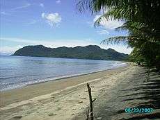
Domestic tourism is mostly those wishing to enjoy the sandy beaches, hotels and resorts along the coastline. Significant numbers also visit for religious festivals such as Sinulog and Limasawa
Most international travellers visit Southern Leyte for the pristine reef diving and snorkeling, from just outside Maasin City, all the way around Sogod Bay via Padre Burgos. There are also an increasing number of non-divers who come to see the Whale Sharks between October and April.
In recent years there has been a drive to promote tourism in the region. There is a new Zoo and Wildlife Park in Brgy. Danao in Maasin City. Not far from Sogod is a zip line over the tallest bridge in the Philippines.
With this increase in numbers, there are a selection of new hotels along the coast.[36]
Industries
Abaca fiber helps livelihood in the province. Women in the selected areas go into abaca-based handicrafts, which is widely known in the area as tagak or spooled abaca fiber. Natives usually called it as tinagak or continuous spooled abaca fiber. The half-finished product is then made into sinamay or hand woven clothe out of tinagak ready to be made into other sinamay‑based products.[37] Products are being exported by Leyte to Japan. Because of a wide distribution of an industry called tagak, provincial sectors taught farmers on how to cultivate a suitable variety locally called laylay.
In Bontoc, a project was successfully established with a mudcrab hatchery with eleven hatchery tanks at the RKKMAFTI Compound. Initially, 25 spawners are being worked-on by the project.[38]
Aside from abaca-based products, ceramics and handicraft items made from coconut and bamboo are also the province's industry. Among the province’s economic activity includes fishing, livestock and poultry raising.[39]
Generally, rice is the staple food of the province and also includes corn. Mountain‑living folks, however, prefer root crops which are abundant. Native delicacies of the province includes tres marias, bocarillo, 'salvaro, bibingka, and starhoy. They also have their own kinilaw.
Communication
Postal communication is the main mode of communication in the province. There are five telephone exchange companies operating in the province and two radio stations. These two radio stations (Radio Natin and DYSL) are located in Sogod. Other types of communication include SSB radios for government offices, VHF transceiver used by an amateur radio group with main HQ also located in Sogod, Southern Leyte and cellular phones for government and private entities.
Transportation
The existing road network crisscrossing Southern Leyte consists of major arterial highways that link the province to Leyte, passing through two major outlets. On the western part is the Maasin-Mahaplag-Baybay and the central part by the Mahaplag‑Sogod road via the Maharlika Highway. On the eastern part of the province, the opening of the new Abuyog‑Silago Roads provides fast and convenient travel to the eastern towns of Southern Leyte. Maharlika road contributes to the development of the province.
There are six designated bus terminals in Southern Leyte: Maasin, Liloan, Sogod, San Juan, Hinunangan and Silago. However, these terminals are open spaces used by buses as parking areas and are therefore not equipped with buildings and other facilities.
The province has only one existing airport that is located in Panan‑awan in Maasin. This airport is considered a feeder airport with a total runway length of 1,200 metres (3,900 ft) and width of 30 metres (98 ft).
Southern Leyte has a total of 11 seaports, two of which are declared as national ports, the Maasin and Liloan ports, and the 10 are municipal ports. Of these 10 ports, five are operational: Maasin, Liloan, Saint Bernard, San Juan and Sogod. By sea, travel to Cebu from Maasin port takes an average of six hours and a maximum of two hours. A ferryboat from Liloan to Surigao takes three hours.[12]
Southern Leyte has one existing airport, Panan-awan Airport located in Maasin City. At present, however, the airport does not service any commercial flight. It has no terminal and can only accommodate aircraft for general aviation weighing 12,000 pounds (5,400 kg) and below at daytime.
Colleges and universities
|
|
References
- ↑ "List of Provinces". PSGC Interactive. Makati City, Philippines: National Statistical Coordination Board. Archived from the original on 21 January 2013. Retrieved 2 July 2013.
- 1 2 3 4 5 "Region VIII (EASTERN VISAYAS)". Census of Population (2015): Total Population by Province, City, Municipality and Barangay (Report). PSA. Retrieved 20 June 2016.
- ↑ "Travel; Southern Leyte". GlobalPinoy. Archived from the original on 10 April 2005. Retrieved 28 July 2016.
- 1 2 Policy and Advocacy | Haribon
- 1 2 Southern Leyte: Attractions
- 1 2 3 4 5 "The Province of Southern Leyte". National Statistical Coordination Board - Regional Division VIII (Eastern Visayas). Archived from the original on 27 Jan 2008. Retrieved 10 July 2016.
- ↑ Villamor, Col. Jesus A. (1982). They Never Surrender. Quezon City, Philippines: Vera-Reyes Inc. p. 127.
- ↑ "Republic Act No. 2227; An Act Creating the Province of Southern Leyte". The LawPhil Project. 22 May 1959. Retrieved 10 January 2016.
- ↑ "Landslide tragedy stuns Philippines". BBC News. 21 December 2003. Retrieved 18 April 2016.
Up to 200 people may have died in landslides triggered by heavy rains in the central Philippines, officials say.
- ↑ "200 feared dead in Philippine landslides". The Guardian. 22 December 2003. Retrieved 18 April 2016.
Rescuers worked with their bare hands and crowbars to dig out victims after the mudslides began on Friday night. Officials fear at least 200 people are dead and many more are homeless.
- 1 2 3 "Province: Southern Leyte". PSGC Interactive. Quezon City, Philippines: Philippine Statistics Authority. Retrieved 8 January 2016.
- 1 2 "Province of Southern Leyte". Department of Agriculture - Regional Field Unit VIII. 2002. Archived from the original on 5 July 2004. Retrieved 28 July 2016.
- 1 2 3 Regis, Emelina G. (21 March 2002). "Stop Quarrying and Rechanneling Subang Daku of Sogod, Southern Leyte". Sogod Bay (Geocities). Archived from the original on 26 October 2009. Retrieved 28 July 2016.
- ↑ "Tornado destroys village 50 die in Southern Leyte". Samar News. Philippine News Service. 21 December 2003. Archived from the original on 4 March 2016. Retrieved 28 July 2016.
- ↑ PIA Information Services - Philippine Information Agency Archived February 10, 2008, at the Wayback Machine.
- ↑ Veridiano, Ben M. (21 December 2003). "Landslides kill 200 in SLeyte". Manila Standard Today. AP, Reuters. Archived from the original on 9 February 2008. Retrieved 28 July 2016.
- ↑ "Geologists had warned on Leyte mudslide danger". Taipei Times. 19 February 2006. Archived from the original on 12 September 2006. Retrieved 28 July 2016.
- 1 2 "The Provincial Profile of Southern Leyte". Philippine Provincial Profile (Geocities). Archived from the original on 25 September 2004. Retrieved 28 July 2016.
- ↑ Quilantang, Chichi K. "The potential of Southern Leyte's Vegetable Industry". Deutscher Entwicklungsdienst. Archived from the original on 21 August 2006. Retrieved 28 July 2016.
- ↑ "Southern Leyte Coral Reef Conservation Project: July 2006 update". Coral Cay Conservation. 11 August 2006. Archived from the original on 16 May 2008. Retrieved 28 July 2016.
- ↑ "Republic Act No. 8796 - An Act Converting the Municipality of Maasin into a Component City of the Province of Southern Leyte to be Known as the City of Maasin" (PDF). House of Representatives of the Philippines. 11 July 2000. Archived from the original (PDF) on 3 March 2016. Retrieved 17 April 2016.
- 1 2 3 "Region VIII (EASTERN VISAYAS)". Census of Population and Housing (2010): Total Population by Province, City, Municipality and Barangay (Report). NSO. Retrieved 29 June 2016.
- 1 2 3 4 "Southern Leyte: from Negative to a Positive Growth Rate in the Late 90'S". National Statistics Office. 3 September 2002. Archived from the original on 7 February 2012. Retrieved 28 July 2016.
- ↑ "Mamanwa". National Commission for Culture and the Arts. Archived from the original on 21 March 2008. Retrieved 28 July 2016.
- 1 2 Arpon, Johann Hein B. "Victims of the Killer Landslide". Bulatlat. Archived from the original on 10 February 2008. Retrieved 28 July 2016.
- ↑ "Places of Interest". MaasinCity.com. Archived from the original on 24 April 2010. Retrieved 28 July 2016.
- ↑ "A short Philippine History before the 1898 Revolution". Society of St. Pius X in Asia. 2001. Archived from the original on 5 July 2016. Retrieved 28 July 2016.
- ↑ "Southern Leyte Philippines". Select Philippines. Archived from the original on 5 October 2006. Retrieved 28 July 2016.
- ↑ Dorado-Alegre, Joycie. "The Islands of Leyte and Samar". National Commission for Culture and the Arts. Archived from the original on 10 February 2008. Retrieved 28 July 2016.
- ↑ "Southern Leyte Is Famous For...". WOW Philippines. Archived from the original on 12 February 2008. Retrieved 28 July 2016.
- ↑ Martin, Bob (20 November 2006). "German council embarks on Region 8 value chain study on coconut". Nov 20, 2006. Retrieved 28 July 2016.
- ↑ Martin, Bob (17 August 2007). "Beetle threatens survival of RP's coconut industry". Archived from the original on 16 February 2008. Retrieved 28 July 2016.
- ↑ Felix, Rocel C. (7 April 2006). "Genetic Engineering Eyed to Solve Problems of Abaca Industry". NewsFlash.org. STAR. Archived from the original on 3 March 2016. Retrieved 28 July 2016.
- ↑ "Abaca Industry Situationer Report". Department of Agriculture - Agribusiness and Marketing Assistant Service. Archived from the original on 16 December 2009. Retrieved 28 July 2016.
- ↑ Erna S. Gorne (30 October 2006). "Bunchy top virus in Southern Leyte scales down abaca production". PIA Information Services - Philippine Information Agency. Archived from the original on 5 May 2007.
- ↑ "Tourism In Southern Leyte". SouthernLeyte.com.
- ↑ Subang, Jane (27 July 2005). "Poverty-free zones in Southern Leyte". Philippine Ventures & Destinations (Blogspot). Archived from the original on 8 July 2011. Retrieved 28 July 2016.
- ↑ "2002 Annual Report; Highlights of Accomplishments". Department of Science and Technology- Regional Office No. 8. Archived from the original on 10 February 2008. Retrieved 28 July 2016.
- ↑ "Region VIII; Leyte--Northern Samar". Living in the Philippines. Archived from the original on 4 May 2003. Retrieved 28 July 2016.
External links
-
 Southern Leyte travel guide from Wikivoyage
 -
 Media related to Southern Leyte at Wikimedia Commons
 -
 Geographic data related to Southern Leyte at OpenStreetMap
 - Local Governance Performance Management System
 |
Leyte | Leyte Gulf | | |
| Bohol / Canigao Channel | |
Surigao Strait / Dinagat Islands | ||
| ||||
| | ||||
| Bohol Sea | Surigao Strait / Surigao del Norte |


